Mega-Temples, Malta
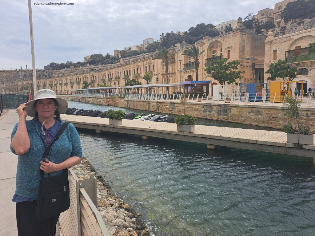
Becky (my wife) and I explored some of the Megalithic Temples of Malta during a Mediterranian-Cruise in June of 2023. We docked at the port in La Valletta, (pictured below).
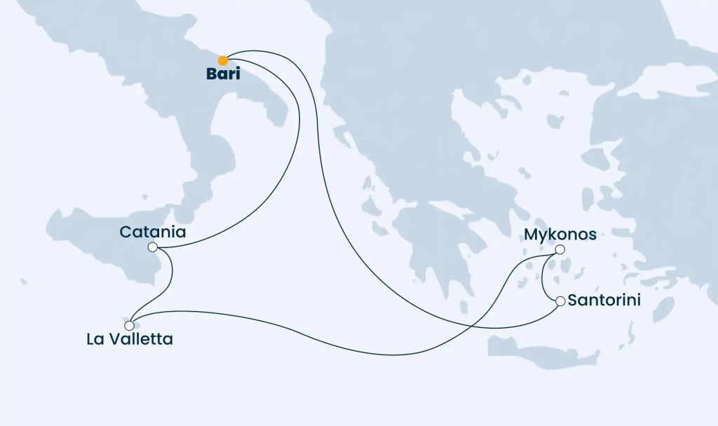
The Maltese Islands, located in the center of the Mediterranean, lie 90km south of Sicily and some 300km east of the Tunisian coastline. The archipelago is 45km long and is made up of Malta, Goza, Kemmuna and a number of smaller islands and islets, (we only trekked Malta).
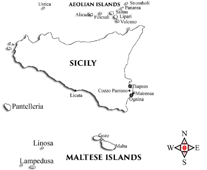
The Maltese archipelago rises up to 253m above sea level along the Pantelleria Rift on the submarine shelf that extends from Sicily to Tunisia. The fault patterns of the Maltese islands are the result of tectonic movements by the European and African plates. However, the Malta island is characterized by two main fault systems that represent the effect of two separate rifting episodes taking place in the vicinity. The older of the two fault systems is the “Great Fault” running south-west to north-east, while the younger Maghlaq Fault system runs approximately north-west to southeast. This fault is also responsible for the downthrow of the island of Filfla to sea level, (mentioned later).
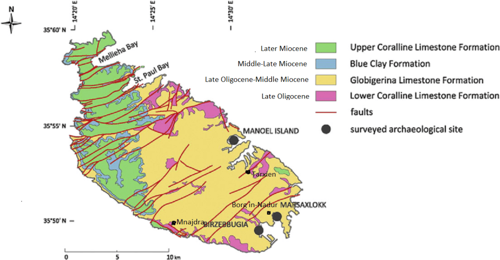
Image above, the geological history of the Maltese Island falls mainly in the lower and middle beds of the Tertiary system, know as the Oligo-Miocene. The stratigraphic deposition is composed of five main layers:
- The Lower Coralline Limestone, (fossilized with coral & is 140m thick).
- The Globigerina Limestone, (yellow-pale grey limestone that covers most of the central and southern portion of the island. Used for building material).
- The Blue Clay, (easily weathered blue to grey clay that is 20-70m thick).
- The Upper Coralline Limestone, (occurs mainly in the western part of Malta and is softer & more porous limestone that is 30-162m thick. The crust seems to exhibit a toughened skin).
- The Quaternary deposits, (forming 5 million years ago after the island emerged from the sea. Climate changes from glacial to temperate to warm).
Our goal on Malta was to visit and explore the temples of Hagar Qim, Mnajdra and Tarxien, which are unique architectural masterpieces, (given the limited resources available to their builders).
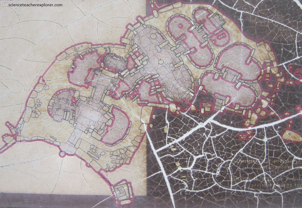
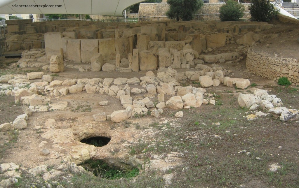
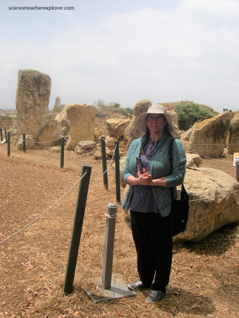
Pictured above, our first visit to a Megalithic Temple was the Tarxian Temples. The Tarxien Temples are an archaeological complex in Tarxien, Malta. The date to approximately 3200 BC, (but probably older). The site was accepted as a UNESCO World Heritage Site in 1992 along with the other Megalithic temples on the island of Malta.
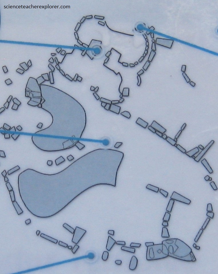
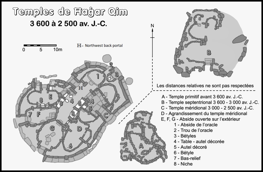
Pictured below, In the Late Neolithic, four Temples were built at Tarxien over a span of over 1000 years, (3600-2500 BC), starting with the modest structure to the East and ending with the large 6-room Central Temple which connects the 3 large structures into one large complex.
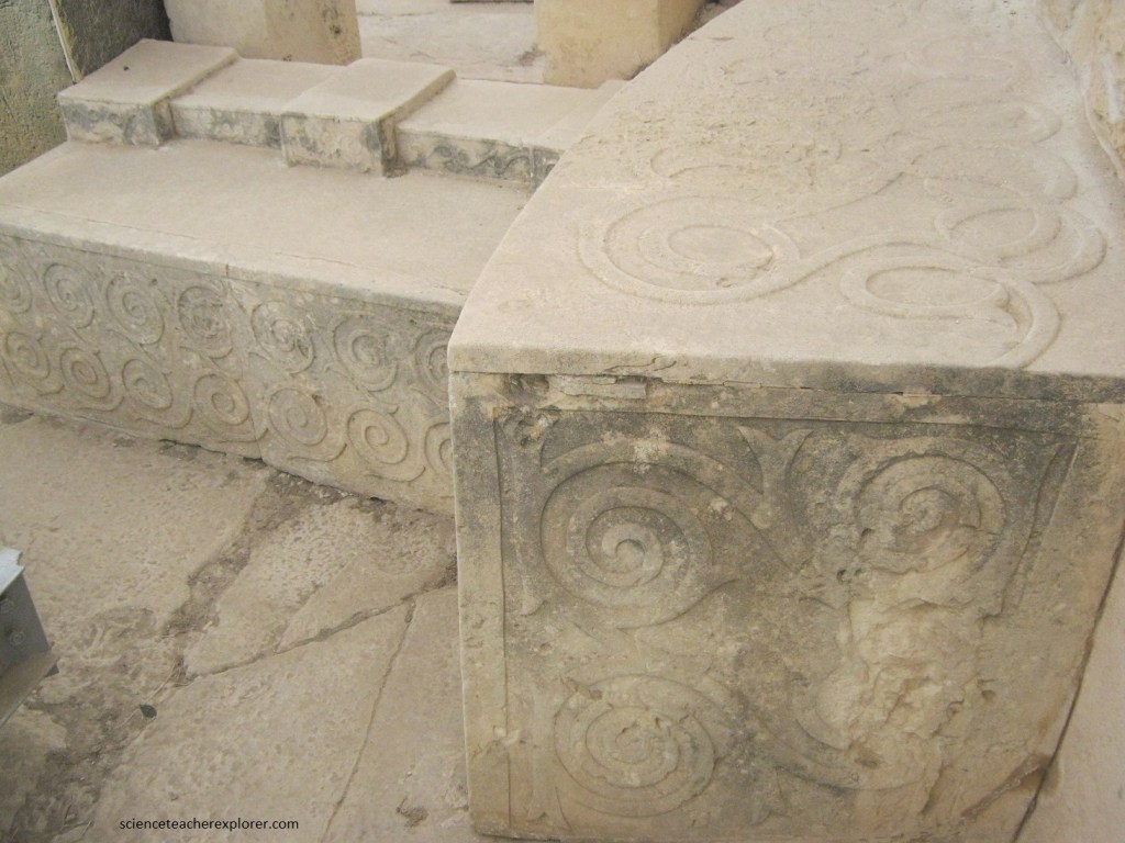
Pictured above, the large main apses have megalithic walls and paving. A stone hearth in the center still has the pink hue which indicates burning. The smaller central apses are unpaved. On each side of the central passage are two screens decorated with four spirals and in the rooms behind them stands a small feature with a shelf. Of the innermost apses, only one retains original walls and torba floor as a wall from the Roman period cut across the Eastern apse. Between the apses, a niche contains a trapezoidal stone which face the Temple’s doorways.
Pictured above, although built in the same period as the “South Temple”, the “East Temple” is a much smaller and simpler structure. Its 4-apses have torba floors and its surviving megalithic walls show a high level of skill. One wall, altered or lost when the last temple was built, was reconstructed in the 1920s. Several small rooms immediately outside the walls may have been linked to this Temple by holes or spaces left in the wall although later alterations make this hard to read.
Pictured above, the Tarxien Cemetery consists of an ashy deposit in which the remains of human burials were found. These contained pottery, copper tools and personal ornaments made of fish vertebrae, faience, ostrich egg shells, sea shells and pebbles. Discoid figurines were also found within the deposit. These figurines are highly schematic, but show seated figures with a flat circular body and a small head. They are decorated with deep incisions and shark’s tooth marks.
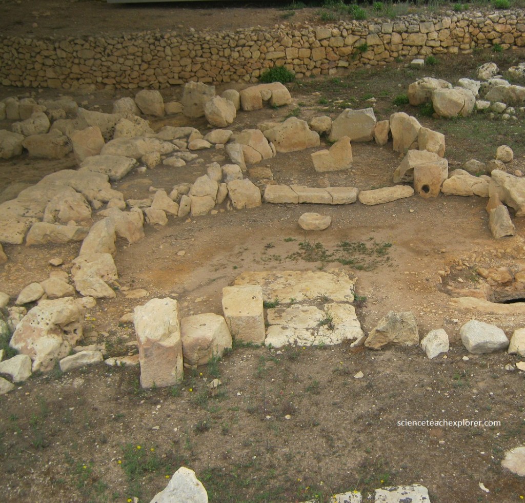
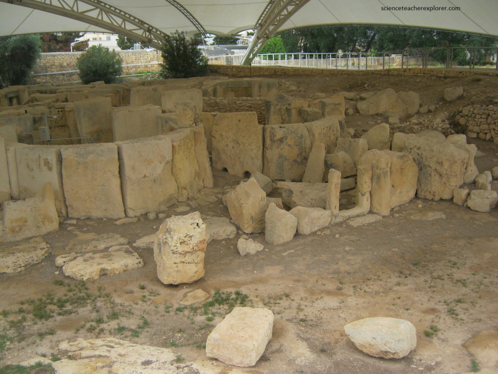
Pictured above are the remains of the earliest of the Tarxien buildings, built between 3600 & 3000 B.C.; Built of smaller stones on the highest point of the site, this Temple suffered greatly during the years when this was a field being ploughed for farming. From where the photo was taken in 2023, we could still make out the typical concave facade, the main doorway with its raised threshold, central passage leading to 5 apses and , on the back, the remains of its external wall.
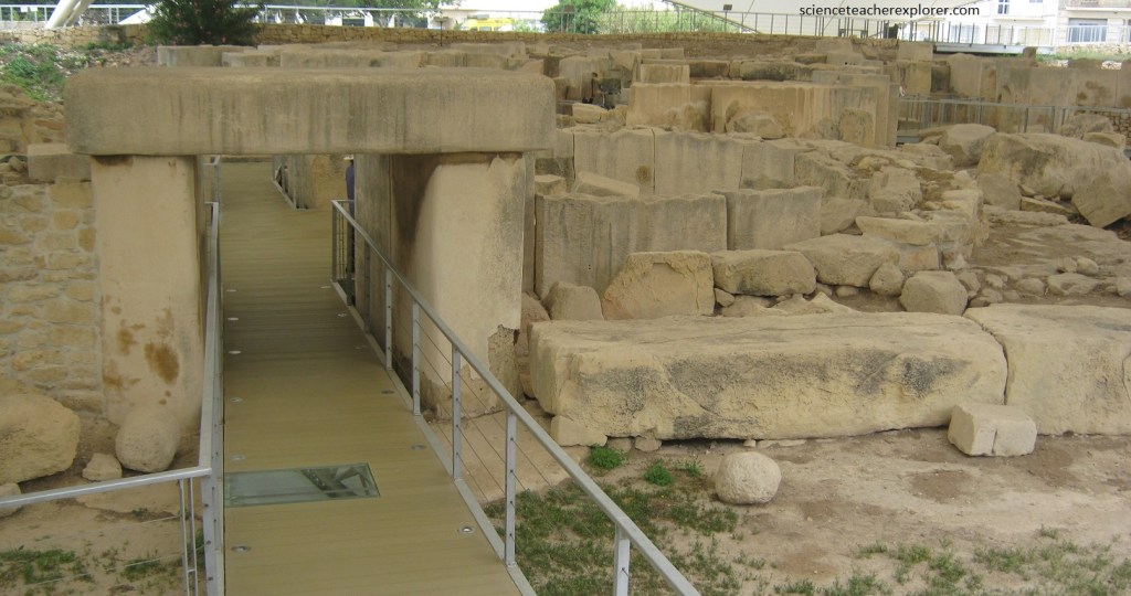
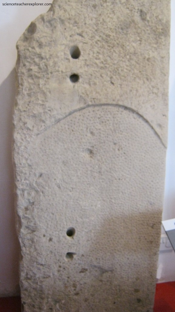
Of the typical megalithic facade of the South Temple only the lower part survives. At either end are large stone slabs, one of which has a raised ledge and five holes. It is unknown whether these were used to pour offerings into the ground or for some other purpose. Pictured above, the current doorway is a reconstruction built in the 1950s inspired by the typical trilithon doorway of most temples and on fragments of a stone model of the facade discovered in this temple. The appearance of the original doorway is unknown.
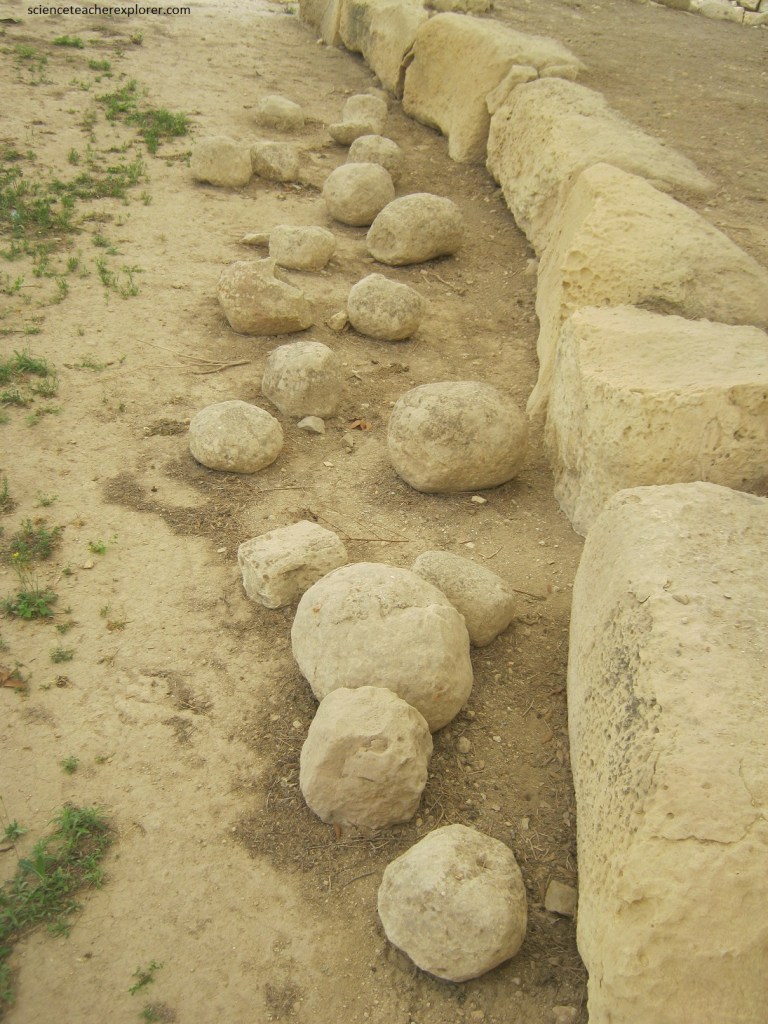
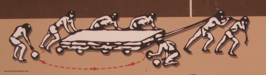
Some of these stones weigh as much as an elephant. Many people think that the temple builders moved them with the help of these stone spheres and a lot of teamwork!
In the Tarxien Temples we find the largest collection of stone sculpture to be discovered in any of Malta’s Megalithic Temples, to date. The apse in the photos above and below holds abstract, spiral designs and a colossal statue of a skirted human figure, similar to the smaller statuettes of corpulent figures discovered at other temple sites. All these designs were made using only stone and bone tools.
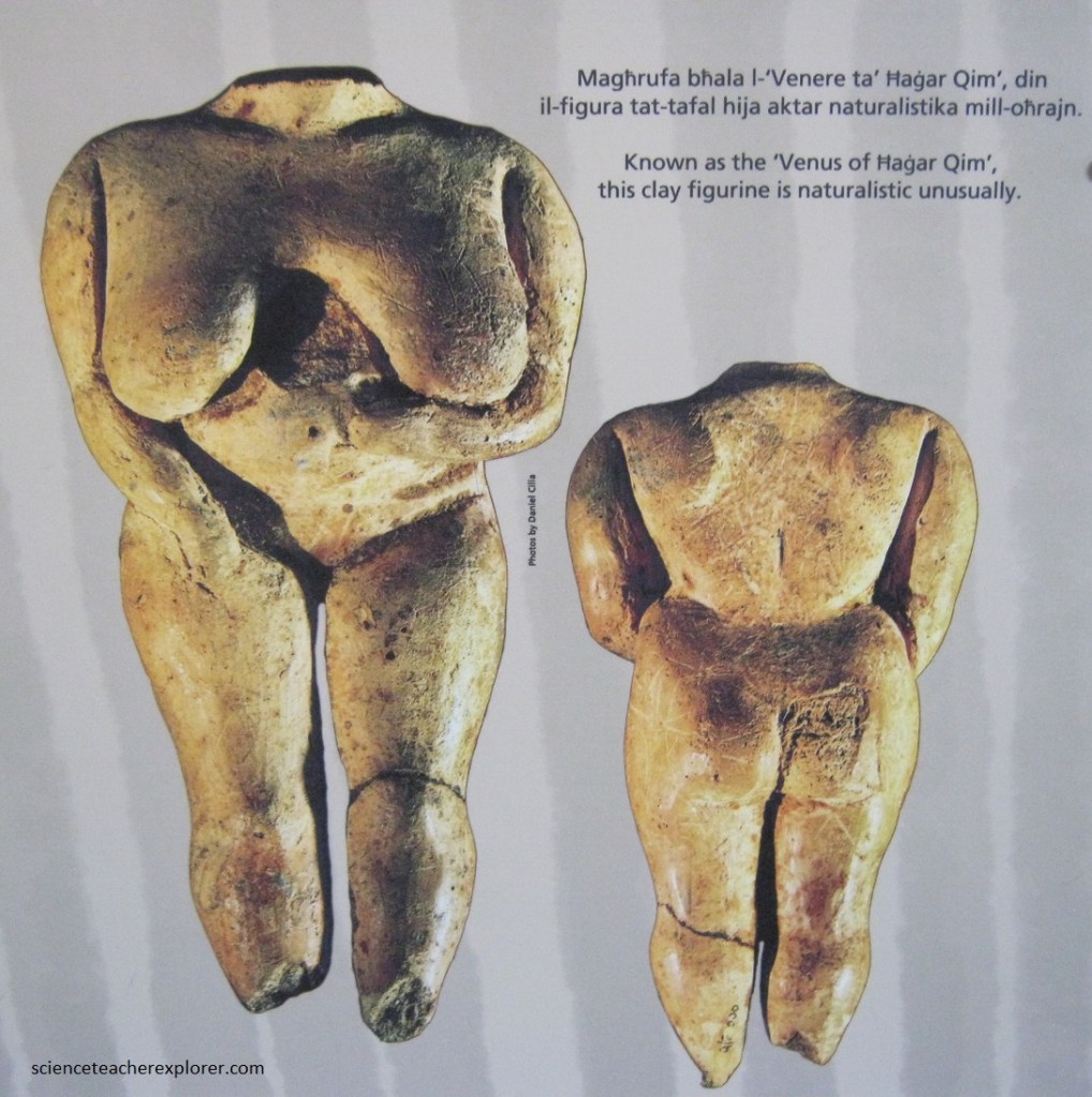
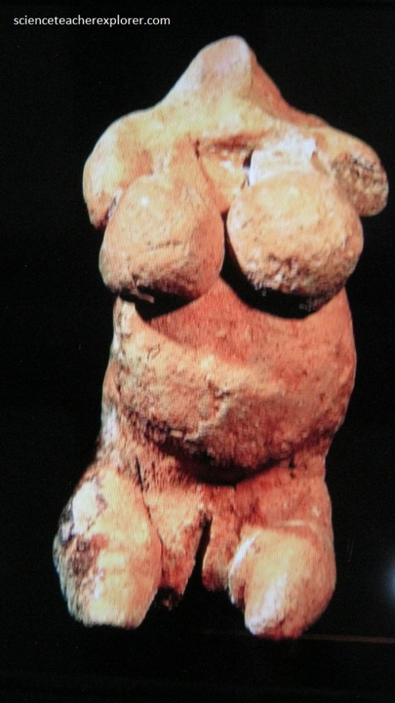
During the Temple Period, the human figure is represented in stone or clay. Pictured above, figures are modelled or carved in varying sizes, from varying sizes, from very small to colossal, such as the statue found at Tarxien above. Pictured below, the figures are obese, and are often depicted in standing or seated positions. The heads of most of them are missing, but a few of the figures have sockets where separate heads could be attached. The figures have often been referred to as ‘goddesses’, but most examples do not have any clear male or female attributes. Two exception is the standing figurine models in clay, which is a natural representation of a woman’s body.
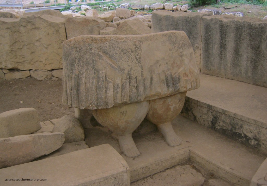
Pictured below, this feature seems to have constituted a focal point in the “South Temple”. The lower half of the original was carved out of a single block of stone. The plugged cavity hewn within its decorated surface, served as a cubbyhole in which a number of flint knives and burnt animal bones were found. The upper half of the altar was constructed with smaller slabs, creating a small space which contained burnt animal remains.
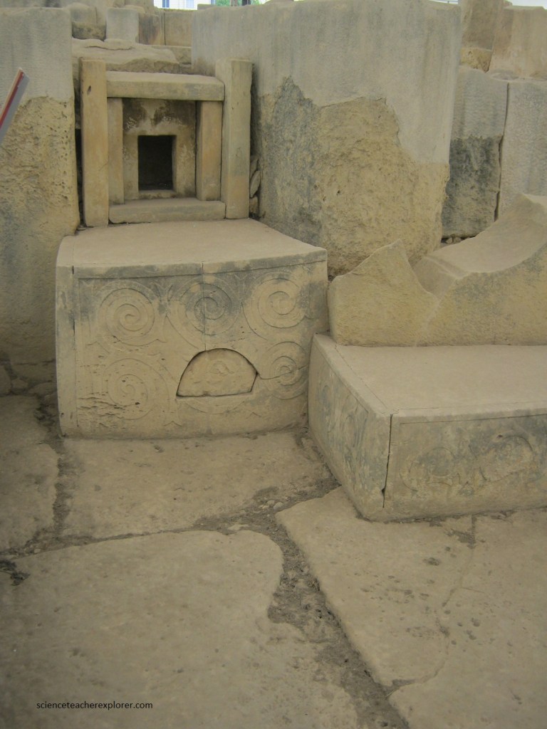
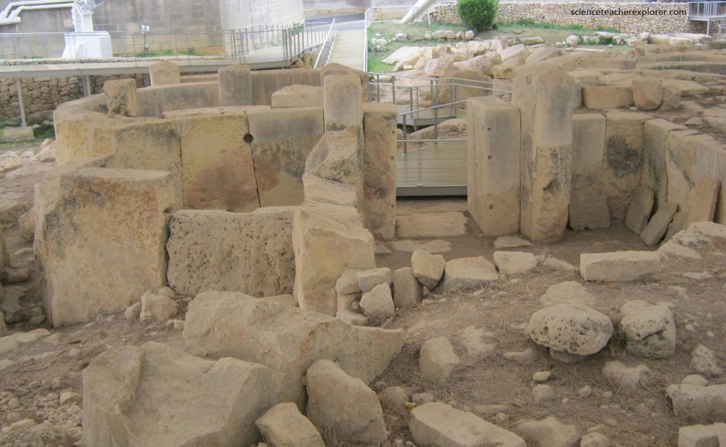
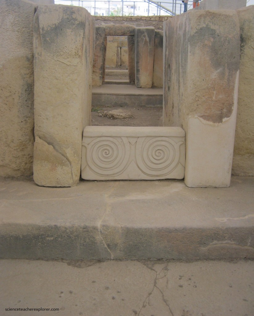
Pictured below, a stone block with two carved spirals, blocks the entrance into the main pathway to the apse of the Central Temple.
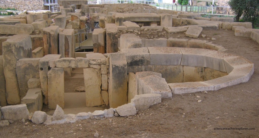
Pictured above, some areas within this temple complex were paved with megalithic slabs. This could have been a means of obtaining the desired floor level on uneven terrain. Here in the Central Temple, the flagstones are particularly large and thick. The South Temple was paved with smaller and thinner slabs while the rest had a simple torba (crushed limestone) floor.
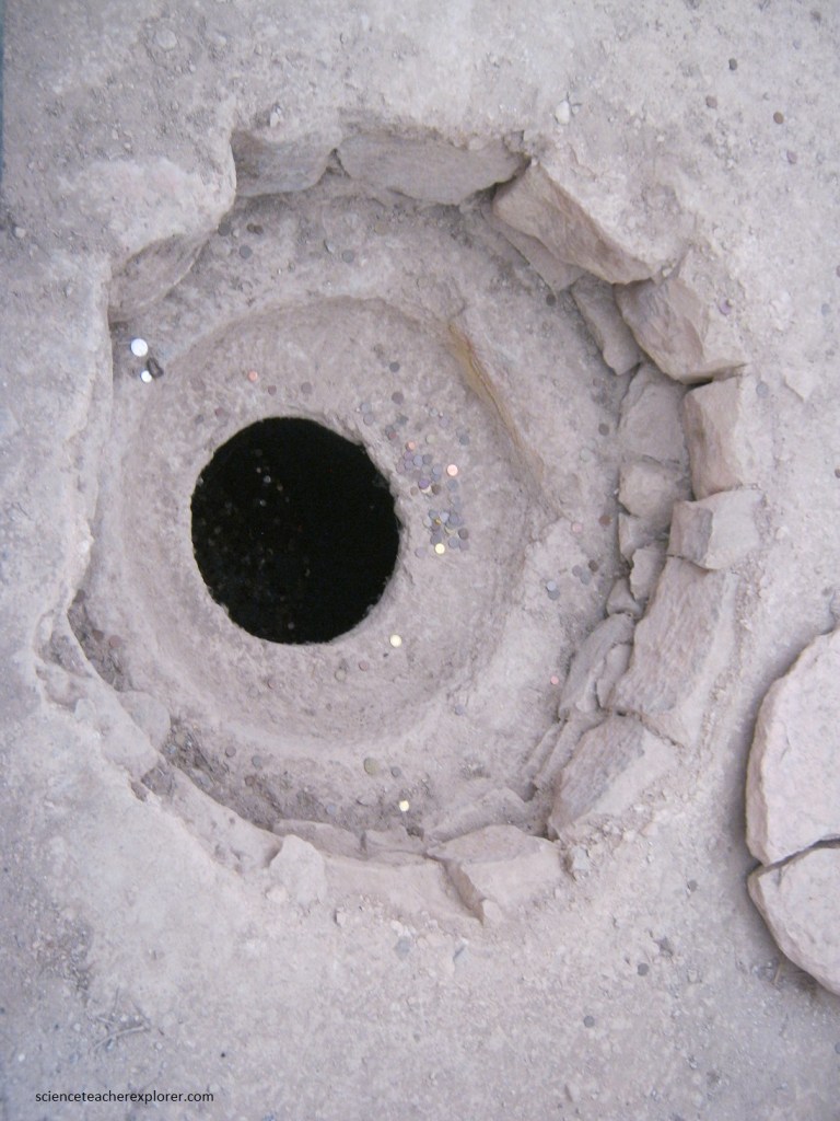
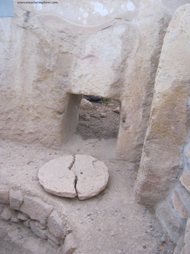
Pictured above, the 1.5m deep pit in front of the carve wall, (bulls and pigs), was discovered empty and sealed with a stone lid under the torba floor of this small chamber.
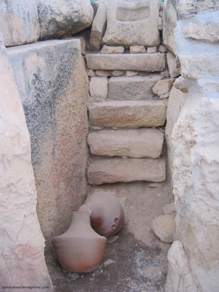
The temples today are like a house emptied of its furniture. But in prehistory the rooms were probably filled with stone pedestals, pottery, figurines and perhaps even colorful textiles or wood objects with did of survive the passage of time. Pictured above, in this small space, two complete jars and fragments of four more were discovered in 1915. As you can see from these replicas, they were large but had small handles in the shape of a tunnel, perhaps to pass a rope through. We still do not know what they contained or what they were used for.
Early in the history of Maltese archaeology, several researchers noted possible astronomical symbolism and alignments in the temples. Especially at Tarxien, a series of stone holes and the orientation towards sunlight were considered intentional attempts to include cosmological bodies within the temple design.
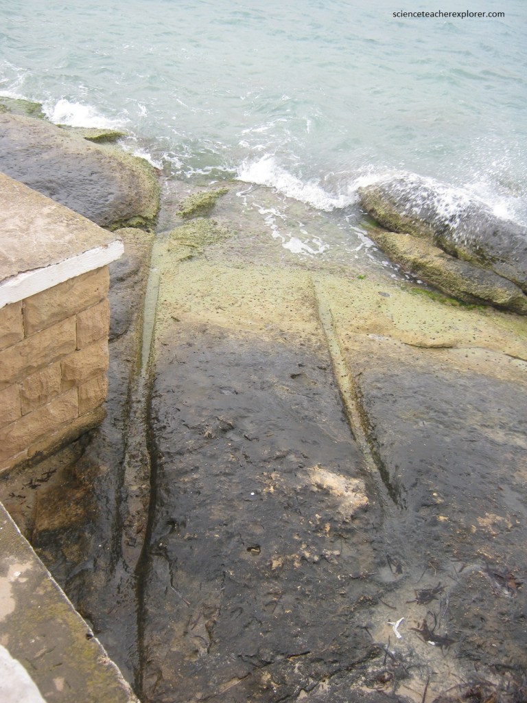
Misrah Ghar il-Kbir is the name given to these prehistoric pairs of parallel grooves, that resemble ‘cart ruts”, (thousands are found all over Malta). The two-tracks run through solid rock (not soft clay, which adds to the mystery) and are thought to be very old, though we don’t know whether they’re natural or manmade, nor their purpose. Because some run into the sea, (the ones pictured above), their uncertain origins have led researchers to speculate that they led to now-long-lost structures, when this part of the sea floor was above water during the ice-age over 12,000 years ago.
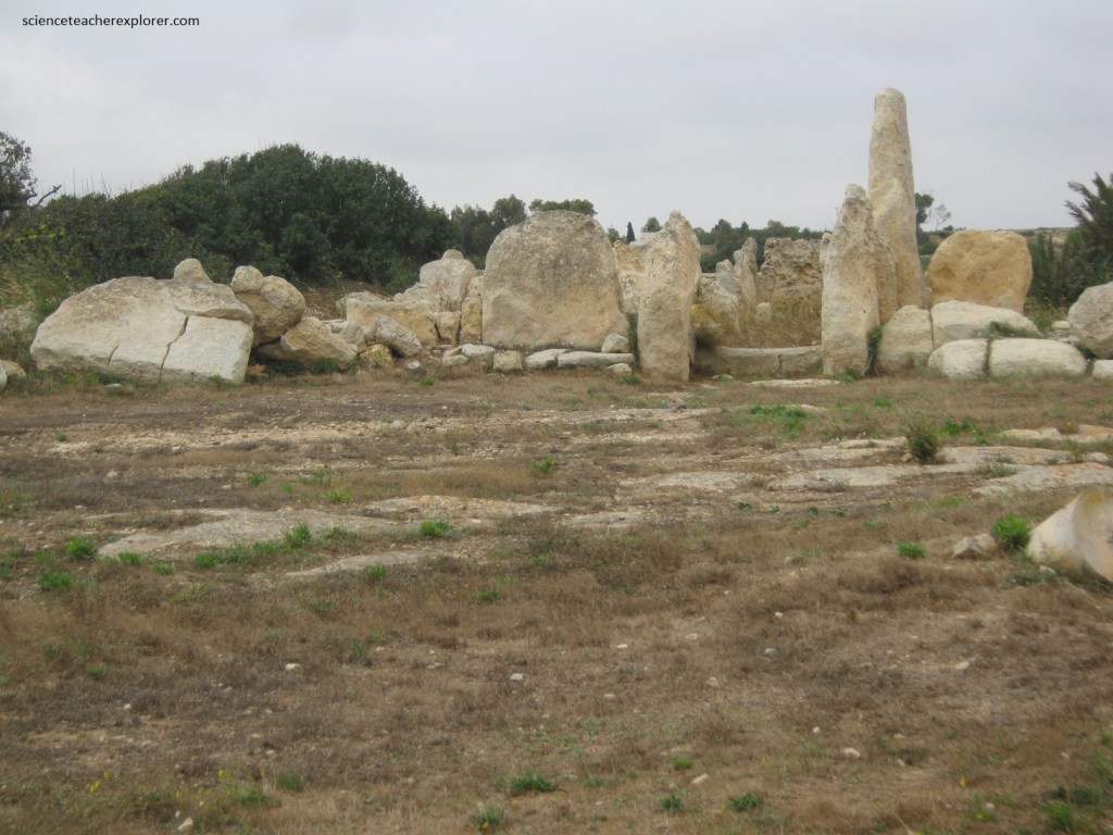
Pictured above, our next Megalithic site was found near the ‘cart ruts’ and called Borg in-Nadur. Borg in-Nadur is an archaeological site located in open fields overlooking St George’s Bay, near Birzebbuga, Malta. It is occupied by a Tarxien phase megalithic temple as well as the remains of a later Bronze Age village which includes the earliest fortification in Malta. Most probably its rooms became part of the Bronze Age village.
A temple was constructed in the area in around 2500 BC, during the Tarxien phase of Maltese prehistory and the last phase of the Temple period.
The architecture shows a typical four-apse plan, although the wall made up of megaliths is quite low. The temple’s entrance has two upright megaliths which can still be seen. A large covered niche stands close to the entrance but its capstone is now broken into three pieces.
Pictured above, the village, with its unique impressive wall was well-defended by the oldest fortification on the Maltese islands. While being in an easily defensible position, it still retained access to the sheltered harbor. Since the protective wall is facing inland, it suggests that the villagers were more troubled by inland attacks than sea assaults. Tools made of stones, flints and artefacts were discovered here.
Pictured above, the 4-apsed megalithic structure within, has typical features of such late Neolithic monuments, including an innermost recess and a concave facade.
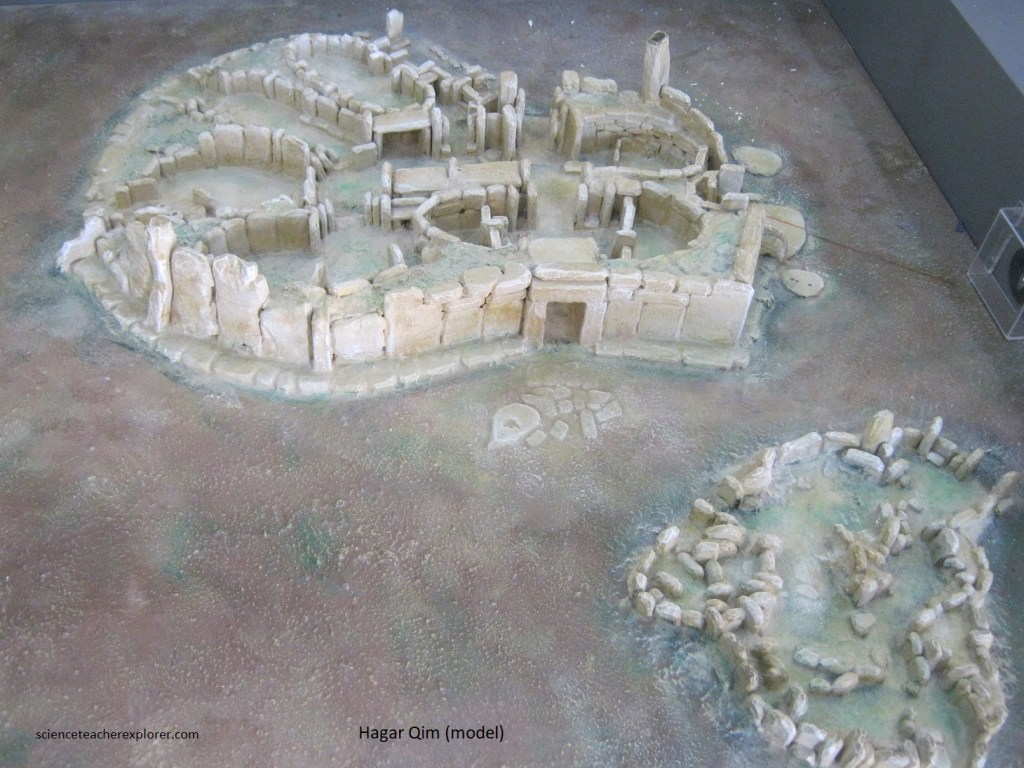
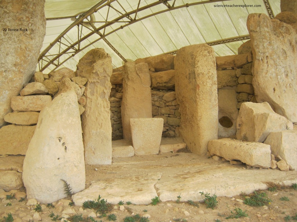
Becky and I visited the next Megalithic Temple site called Hagar Qim/ Mnajdra. Hagar Qim and Mnajdra are found in the garigue landscape along the south-western coast of Malta, 2km from the village of Qrendi. Standing at the top of a ridge, with the ground sloping away on all sides, Hagar Qim has commanding views over the surrounding landscape. There are also two smaller outlying sites and the remains of a wall with the main Hagar Qim building at the center of the complex. Mnajdra Temples, visible from Hagar Qim, are found 500m downhill, above the southern cliffs. Both megalithic complexes were speculated to be built between the 4th and 3rd millennia BC, placing them amongst the earliest monumental buildings of such sophistication on earth.
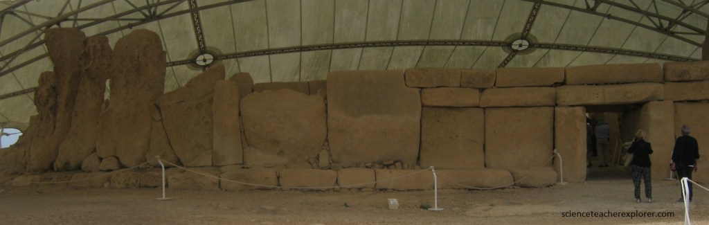
Pictured above, the monumental concave facade has become an icon of the Maltese islands. It faces south-east (900 from north) and is approached across an oval forecourt, (partially paved with stone slabs). Particularly noteworthy in the facade are the larger megaliths which are notched in the corner to old the second course of horizontal blocks. The entrance, is of the typical trilithon construction, consisting of two uprights standing on either side of a threshold and supporting a horizontal lintel.
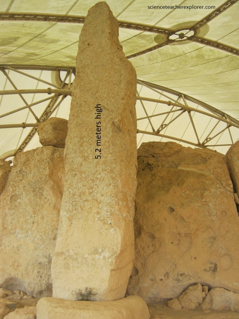
Pictured above, the Hagar Qim facade contains the largest stone used in Maltese megalithic architecture weighing 57 tons. The upright menhir stands 5.2 m.
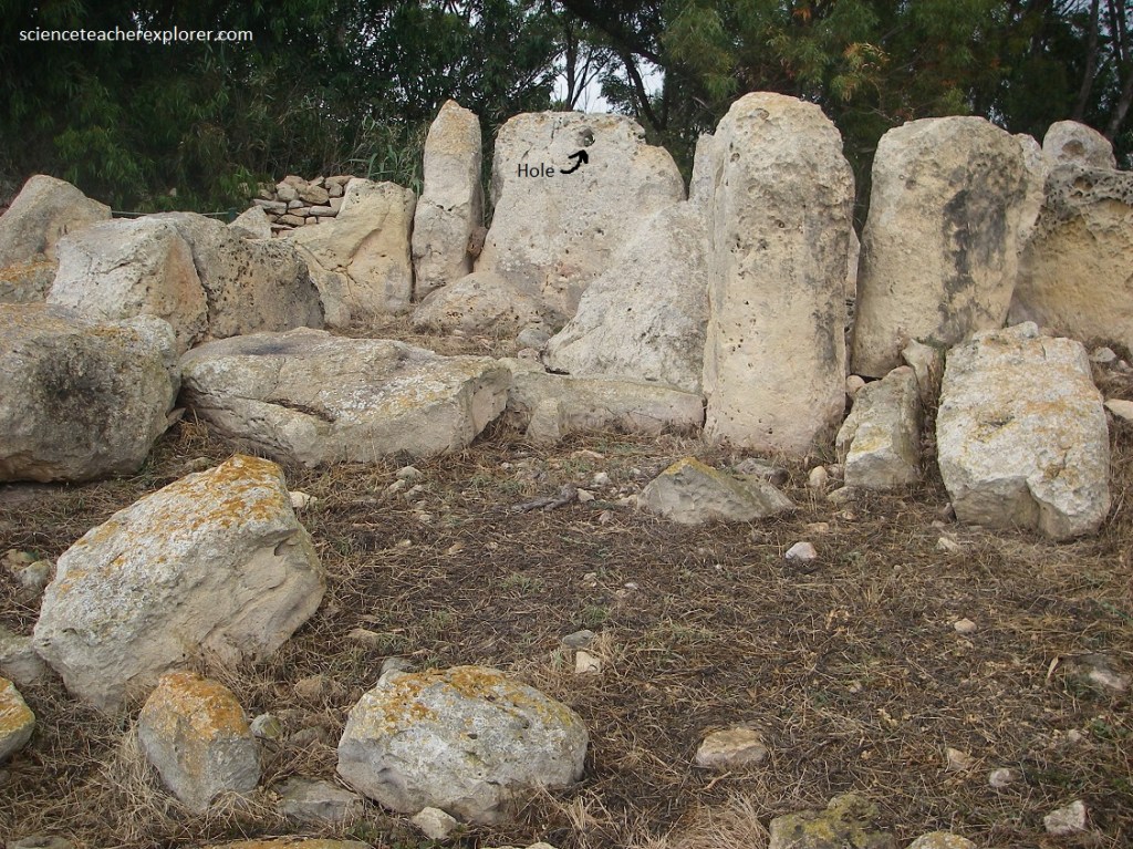
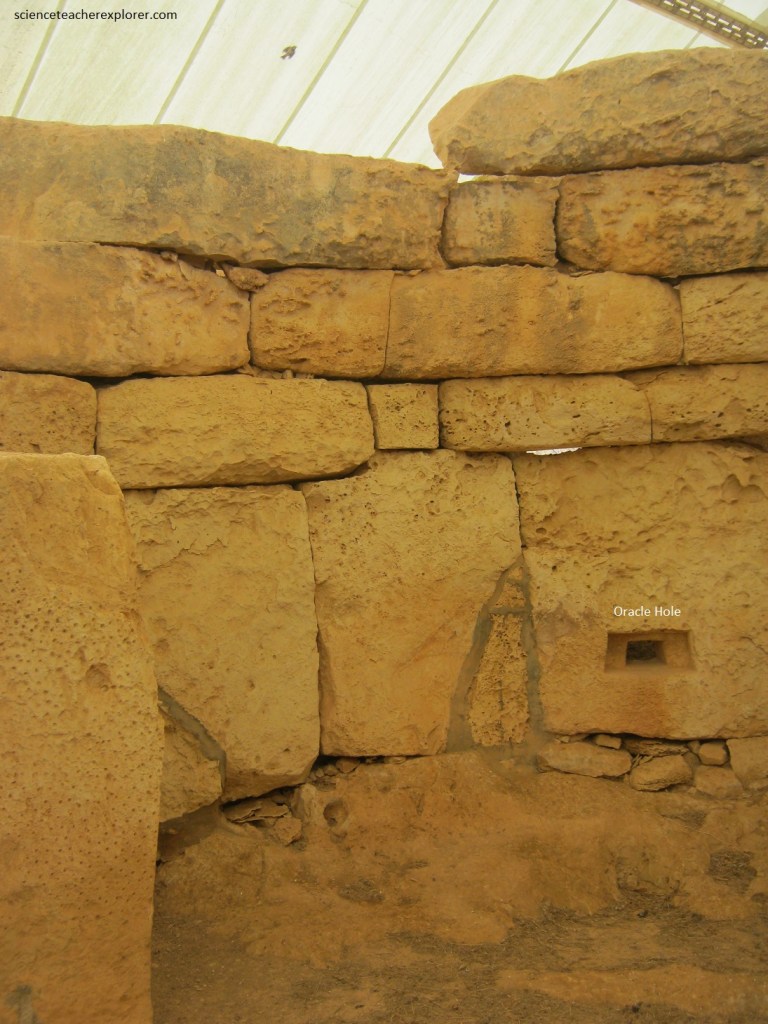
Pictured above, a feature unique to Hagar Qim Temples is this external niche with a 2m high pillar. Beside this niche is the so called ‘oracle hole’ connecting it to the internal chambers. This connects to a room identified as the northern oracular apsis. There is very clearly some type of altar or maybe a type of bench just to the left of the Oracle Hole. One explanation for this is that the person claiming to speak for the oracle would be inside the temple and whisper the answers to someone sitting on the outside, most likely a priest. Sound passed from the main chamber into the recess, and vice versa.
On the other hand, it is claimed that when the sun rises on the Summer Solstice its rays directly penetrate the Oracle Hole which would make it more of an astronomical function than a religious one. In fact at sunrise on the Summer Solstice, a ray of light enters through this elliptical hole in the wall of this northern apse. The light is then projected as a crescent on a stone slab at the entrance to the apse and as the sun rises higher in the sky, the crescent of light travels down the slab onto the floor and slowly turns into a disk.
Imaged above, the front entrance seems to be an outer pair of apses of a transition type with solstice markers about an inner doorway. This front entrance, ‘C’, seems rotated clockwise from an equinox sunrise position by an amount nearly the same as the ‘Middle Temple’ of Mnafdra, (mentioned later). What is curious here, (on the image above) is that sections ‘C’ and ‘H’ appear to be a back to back structure, one set on the sunrise the other on the sunset, during the equinox of the year they were built, (this matches the latitude of Malta’s 38 degrees of North).
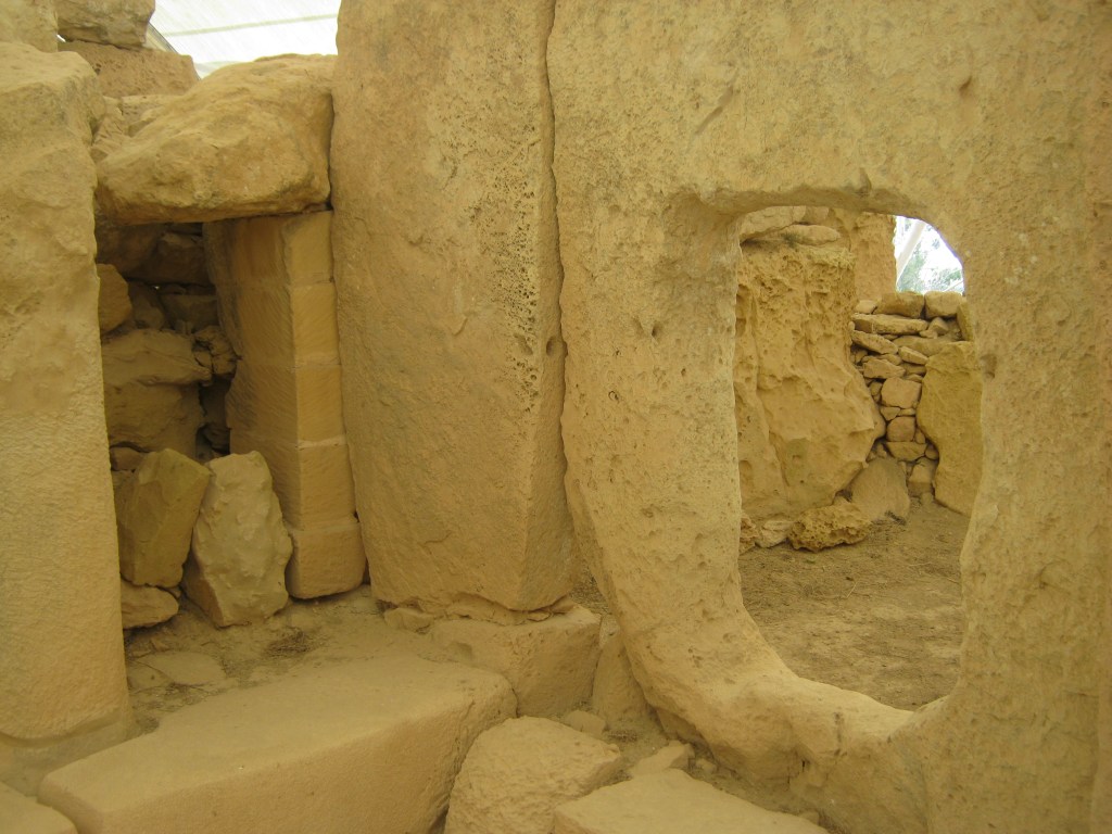
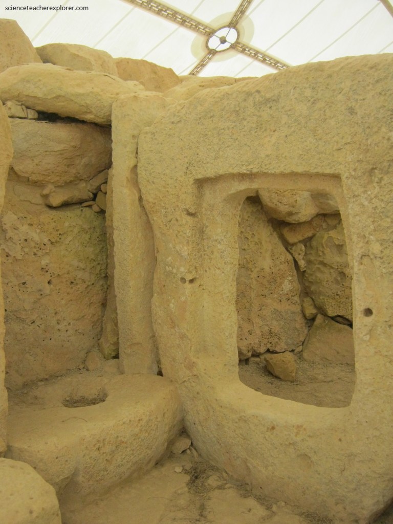
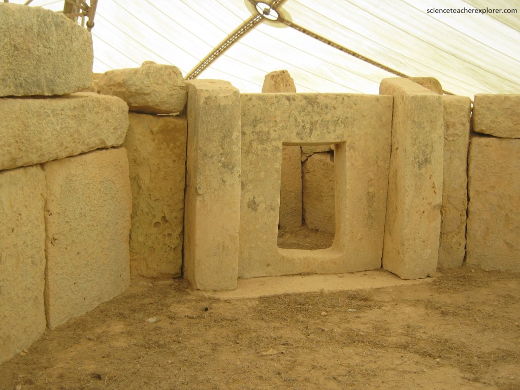
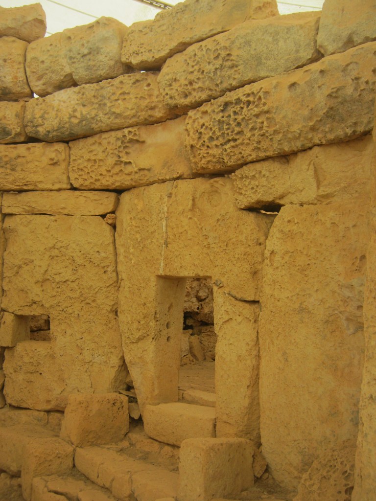
Pictured above the internal chambers, (also known as apses), are screened off from the paved central court by thin slabs. Access is limited to ‘porthole entrances’, stone slabs that have been pierced with rectangular apertures forming small doorways.
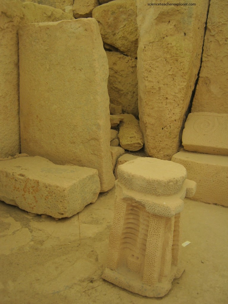
Pictured above, two examples of prehistoric sculpture were found in the first chambers; a stone slab with a pair of opposed spirals, (similar to the Tarxien one), and a free-standing altar decorated on all four sides with what appears to be a potted plant or tree-carved in relief.
The Northern Temple’s first recess contains a round stone pillar and a rectangular slab held vertically ahead of the pillar. Resting on the slab are spherical hollows which may have served as holders in which to stand small libation jars. Jars excavated from the site are characterized by a specifically oval base, designed to stand upright when placed in the slab.
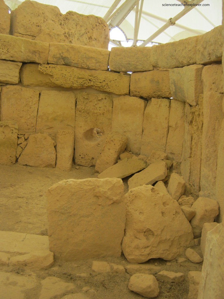
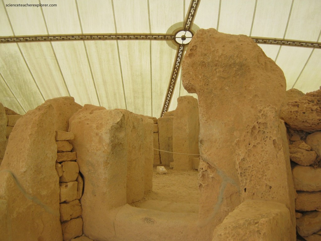
The northern temple is the oldest part of Hagar Qim, containing an oval chamber with a semi-circular apse on each side. Following the second doorway is another chamber with similar apses. Pictured above, the remains of a roof can be found inside the chambers like this one. The horizontal courses above the upright slabs protrude over the one beneath. these courses are the remains of the base of a corbelled roof, the type of construction that may have originally been used to roof over parts of the temples.
Pictured above, the ‘West Temple’ are the remains of a five-apsed building. The left-hand and central apses are still visible, while those on the right-hand side were destroyed before excavation. Being the oldest of the Hagar Qim Temples, it once overlooked the sea in a direction slightly west of south, with an azimuth of 186 degrees. According to the date deduced from the precession of the earth and Malta’s view on the Sirius star, researchers believe it was built in around 9,150 BC. It should be noted, the axis of the Earth is tilted in relation to the plane of the ecliptic. Moreover, the axis is not stable. It moves around in a circular motion which can be compared to the wobble of a spinning top. This movement is so slow that it takes about 26,000 years to complete one round, and it can hardly be noticed in a lifetime, making a shift of only one degree in 70 years.

Researchers claim that, around 9,400 BC, a viewer who stood on the south coast of Malta and looked in a southerly direction would behold an unusual sight. A star appeared in the sky of a brilliance never seen before in the winter time. It was the Sirius star. For viewers at Malta’s latitude, Sirius had been invisible for five thousand years before that date. Now it came into view again in all its splendour, and over the years the time of its visibility in the night sky grew gradually longer. At 9,400 BC, the Sirius Star once overlooked the sea in a direction slightly west of south, with an azimuth of 186 degrees, (a perfect alignment of the Hagar Qim’s ‘West Temple’.
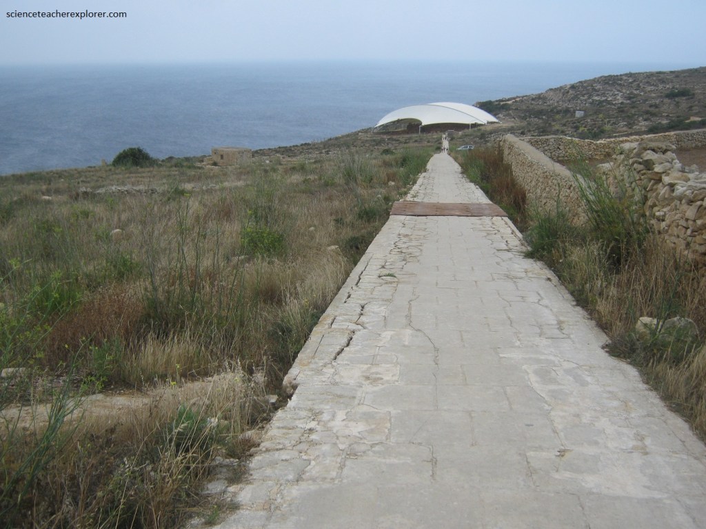
From Hagar Qim, Becky and I walked down to the Mnajdra Megalithic Temples. Pictured above, the Hagar Qim temple complex lies on top of the Globigerina formation while the Mnajdra temple complex situated 500m lower down the hill, sits on the outcropping Lower Coralline Limestone. It seems that Mnajdra sits in a natural hollow, blending in as part of it. It is interesting to note that the main stone used in the construction of the two temple groups reflect the dominant rock formation on which they stand.
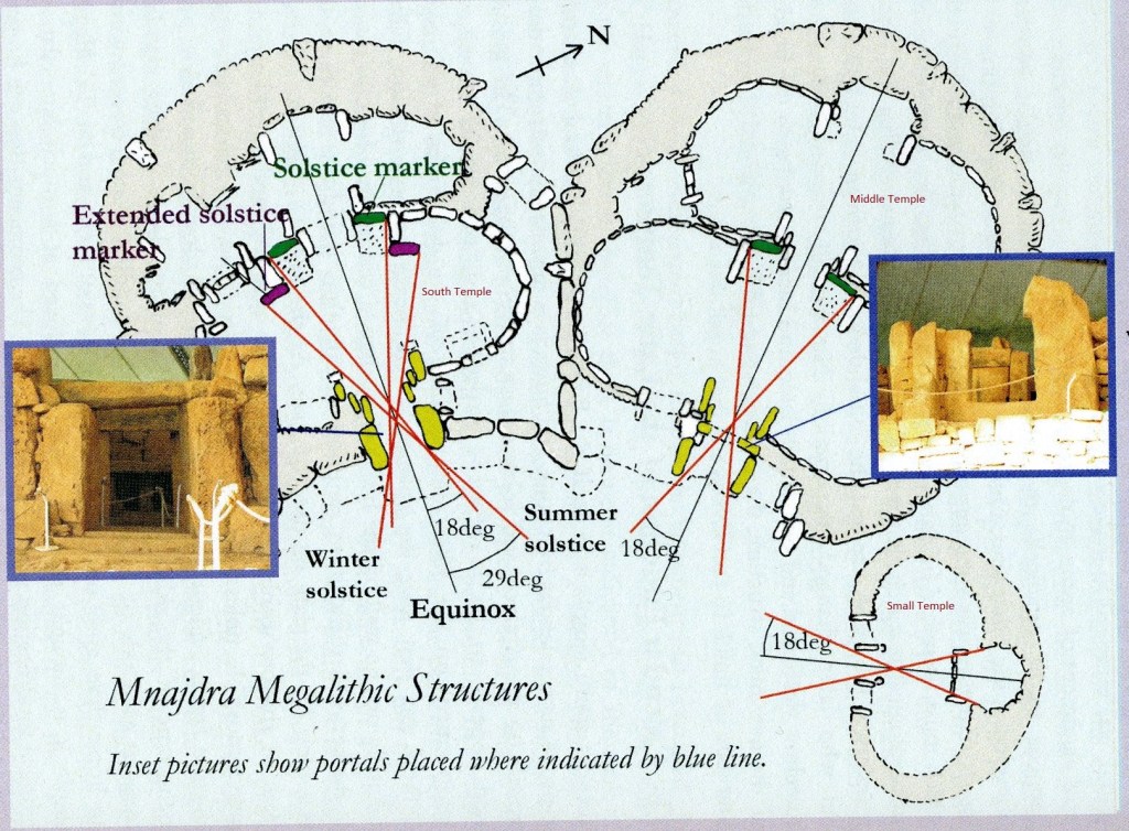
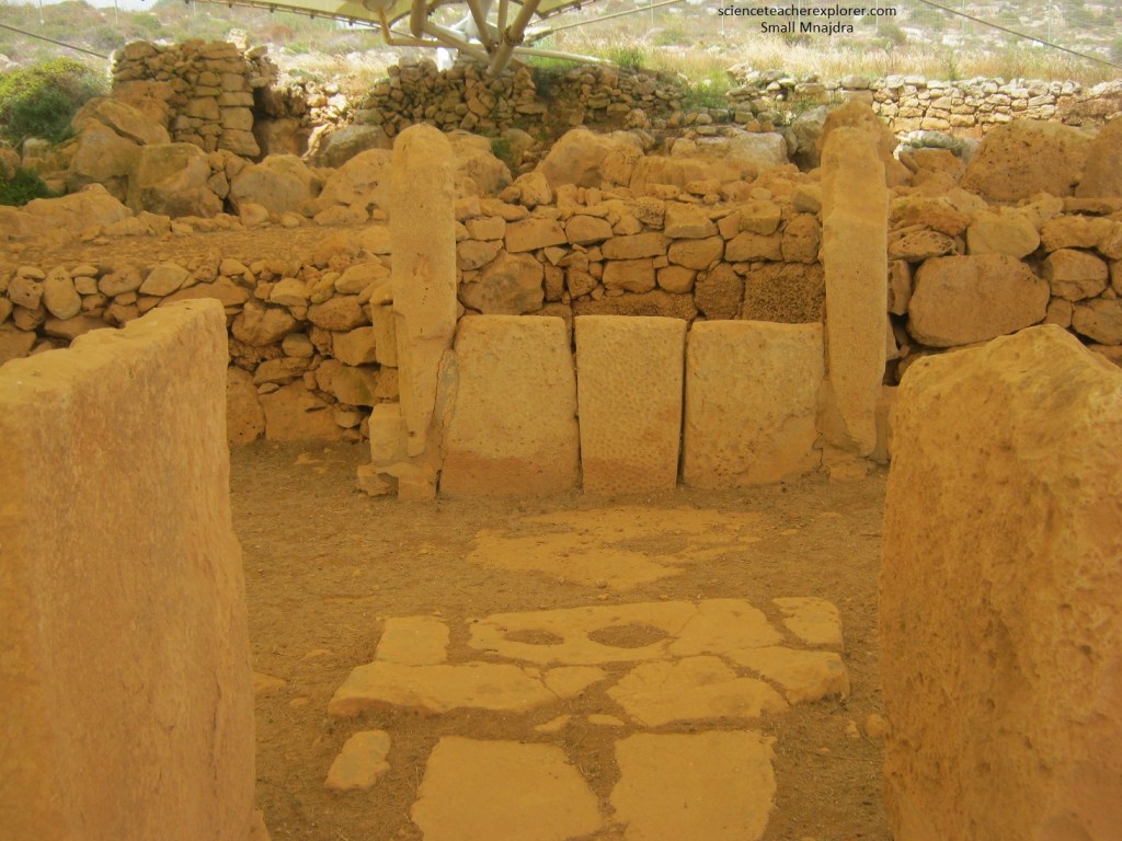
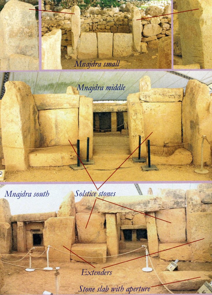
Imaged above, Mnajdra Temples consists of three separate buildings, (Small, Middle & South) accessed across a common forecourt. The forecourt is paved and has a set of interconnected holes in front of the entrance to the South Temple. However, my first approach to the temples was to the ‘Small Temple’ , (with a trefoil plan), on the right. The Small Temple’s entrance is to the south-west and may have consisted of three doorways or openings.
{Side note: It is not hard to notice that the plan-view of the above “middle temple” has the profile of a human female-torso. It is my speculation that the Maltese megalithic temples could be earthly images of the body of the Goddess found in statues around this area, destined to be fertilized by once a year by the solstitial sun. I thought these temples had a strange coincidental shape}.
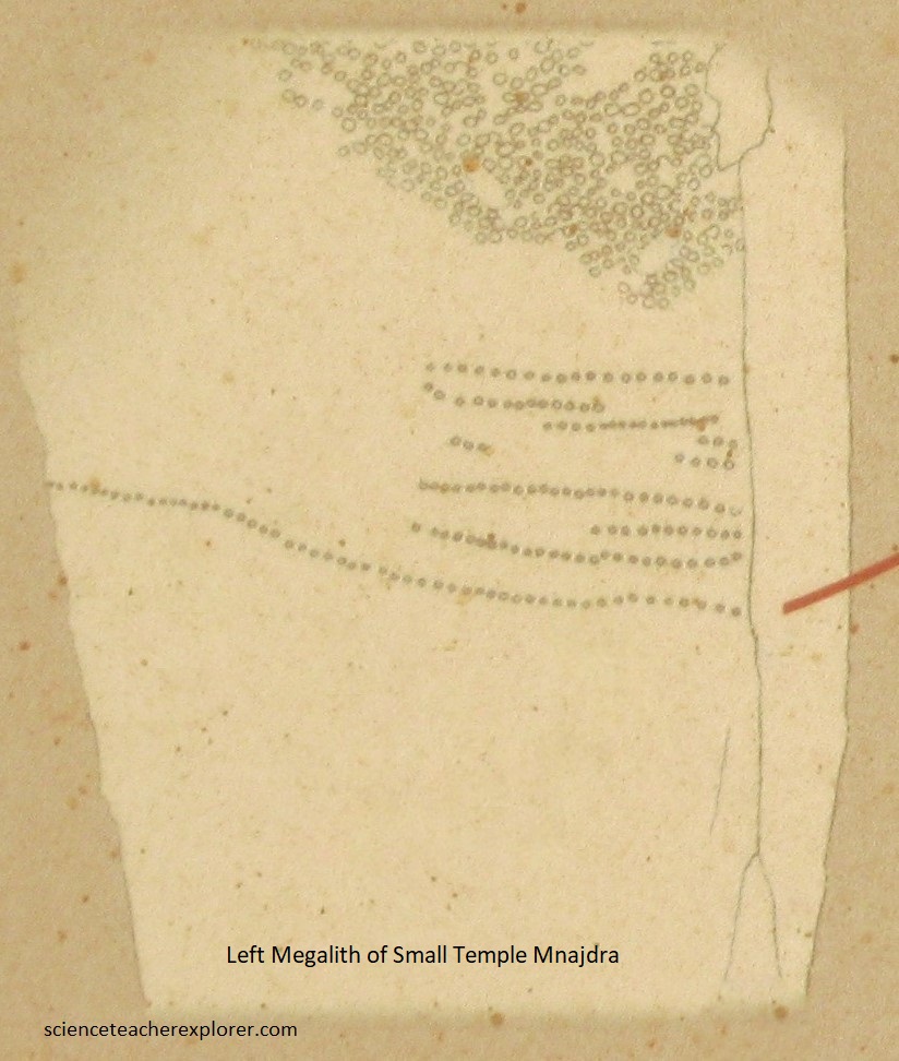
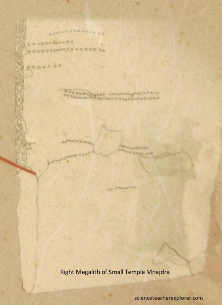
Pictured above, through the front doorways are two wide apses, (big & small). The smaller apse is opposite to the entrance and is closed off by 3 low stone slabs bearing pitted decoration. Flanking these are two higher megaliths which exhibit particular lines of drilled holes, imaged below. These holes have been linked to the rising and setting of particular stars and constellations. Researchers suggests that these holes were a tally of the days between the appearance of one star and another. A star of 6 holes at the very bottom closely resembles the 6 brightest stars of the Pleiades cluster.
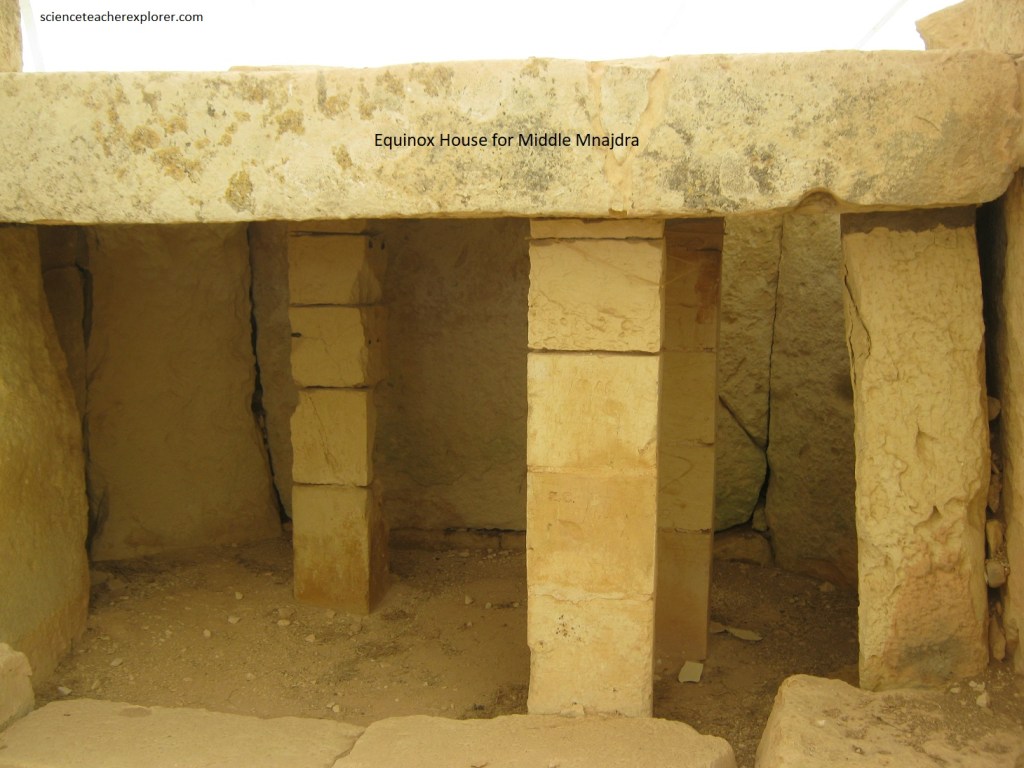
Pictured below, the ‘Middle Temple” is set on a terrace, at a higher level than the ‘South Temple’. This is the newest temple… if one can say “newest” to a structure which was built in the time period between 3000 and 2500 BC. Excavations revealed that this building was constructed on an artificial platform, formed by piling up stones against the wall of the ‘South Temple’ to level off the area over which the ‘Middle Temple was built. The ‘South Temple’ seems to consist of 2 pairs of apses, (outer and inner).
Pictured above, the main access to the ‘Middle Temple’ is through a large porthole slab, fronted by two upright slabs which form a passage in front of it.
Beyond the porthole slabs are two other pairs of uprights continuing the passage into the outer apse. To the left of this entrance, (while going in), there seems to have been another doorway. The pair of outer apses beyond these entrances are relatively bare, having two horizontal courses supported by upright slabs. These uprights in the outer apses have a very smooth finish that contrasts sharply with the rough external walls.
Pictured above, the taller orthostat to the left of the passage, ( illuminated during the summer solstice sunrise), and leading to the inner apses, carries and engraving of a temple facade.
Pictured above, this second passage is pave and opens into two inner apses, (one pair). Pictured below, opposite the passage is a covered niche, while in the left apse, is an entrance to a small chamber which was built into the thickness of the temple’s wall.
Pictured below, the opening to this small chamber is similar to the ones in the ‘South Temple’ consisting of a porthole set within a trilithon arrangement.
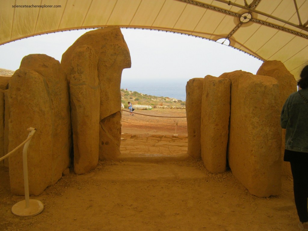
Pictured below, the concave facade of the ‘South Temple’ is oriented towards the east and is constructed in a series of vertical megaliths at the foot of which are horizontal stone blocks forming a bench and providing support for the uprights.
Pictured above, the entrance leads to a paved corridor contstructed in four pairs of vertical slabs. The passageway widens toward the interior and holes in the last pair of uprights were probably meant to hold some form of screen or door.
Imaged above, the entrance passage opens onto a large space, with an outer-apse on either side. In the apse on the left is a niche covered by a vertical slab, and an elaborate entrance to an inner-left-apse, (pictured below).
Pictured above, this entrance consists of a porthole entrance set within a trilithon and flanked by two tapered vertical slabs, all of which bear pitted decoration. Considering the elaborate entrance of this inner-left-apse, it appears to have held particular significance. The small inner-left-apse beyond this entrance holds two double-tiered altars. [Note: I was unable to get this picture because it was currently roped off].
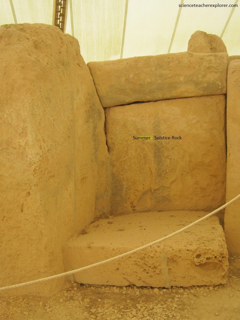
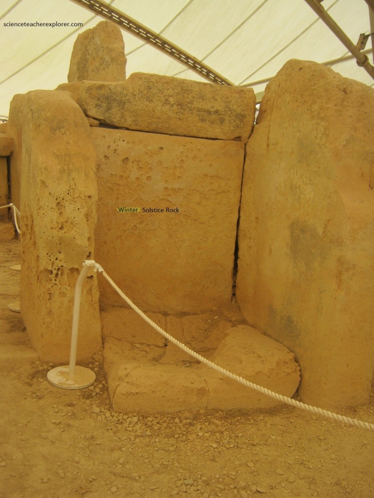
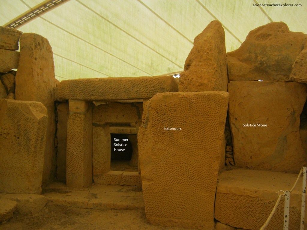
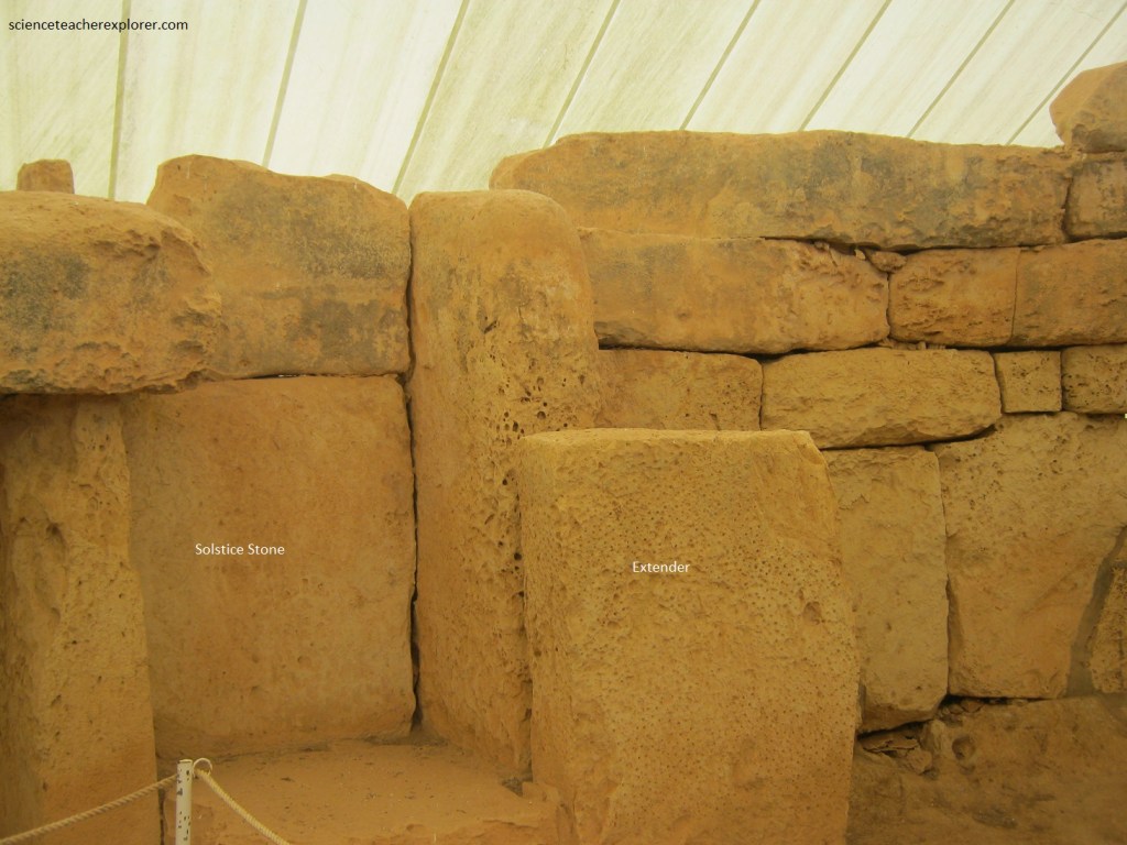
Pictured above, opposite the main entrance to the temple is a passage leading from the outer apses to the inner ones (left and right). This passage is flanked on either side by tapered slabs which are also covered with pitted decoration. These slabs are of particular significance since they were and are used to mark the summer and winter solstice sunrise. The passage is roofed with stone slabs and a threshold is found between the second pair of uprights.
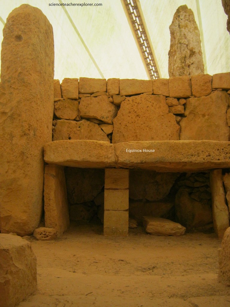
Pictured above, the niche opposite the passage contains a table slab supported on two pillars.
Pictured above, in the outer chamber apse, the northern-right apse wall and upper horizontal courses slope inwards to narrow the opening which was originally spanned by a roof. In this wall there are two small openings, one which is only accessible from the rear of the temple, (called the oracle hole), and the other opens onto a hidden chamber.
Pictured below, researchers of the Megalithic Temples of Mnajdra suggest that the people who built them had an interest in astronomy; the movements of the stars, sun and moon.
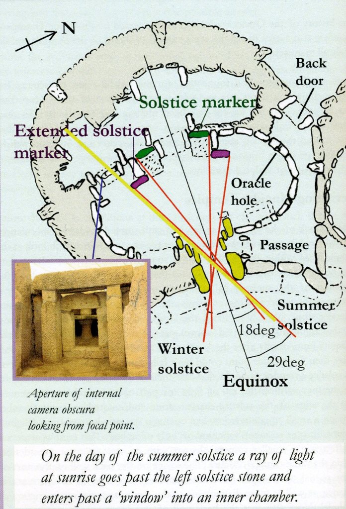
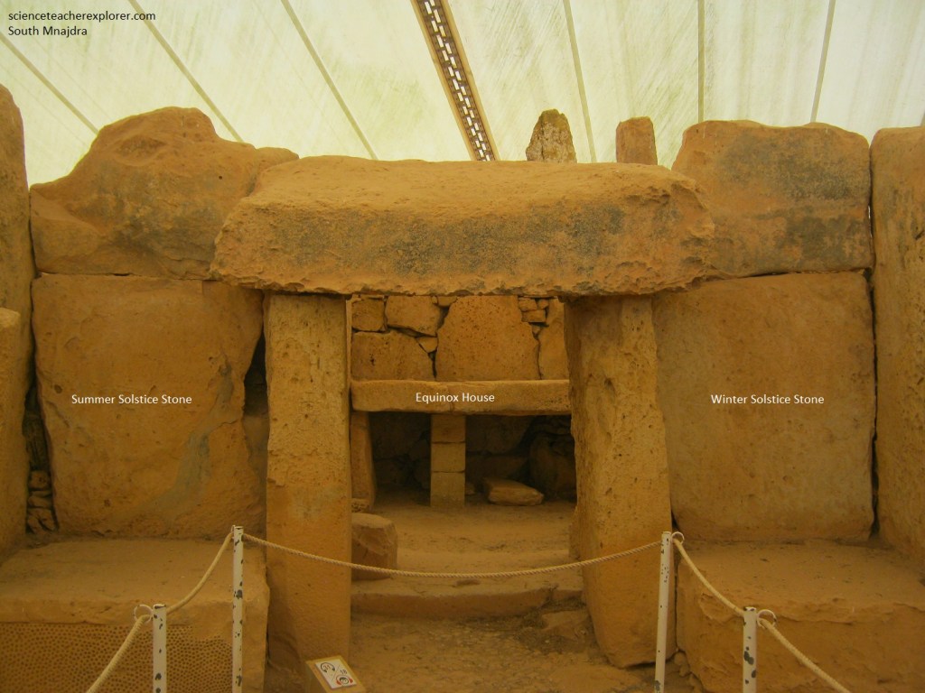
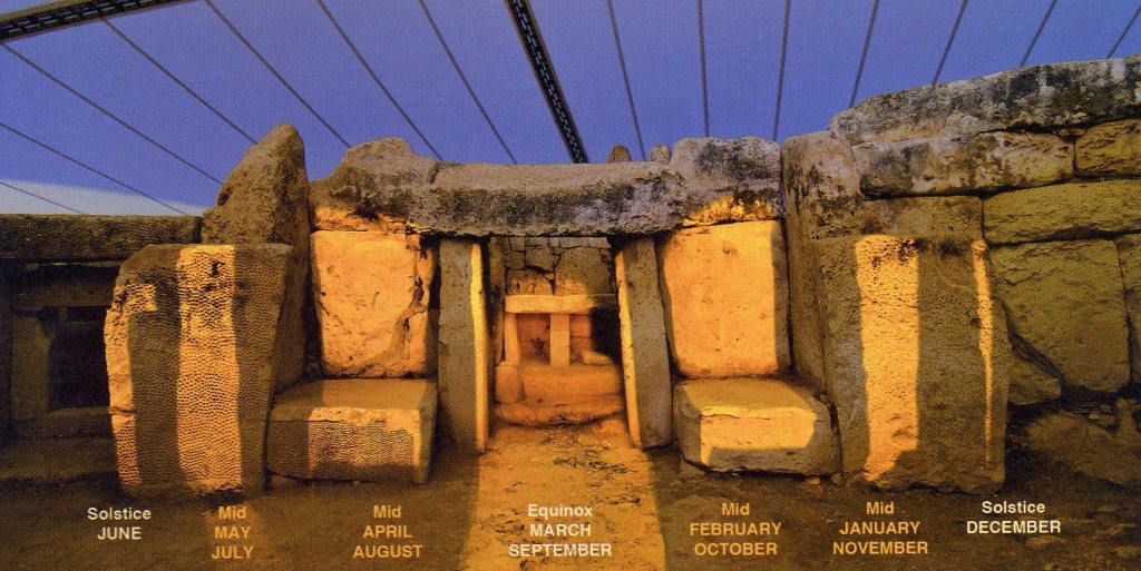
The strongest evidence for this come from Mnajdra ‘South Temple’ where the whole building seems to have been built to mark the sunrise on the Equinoxes and Solstices.
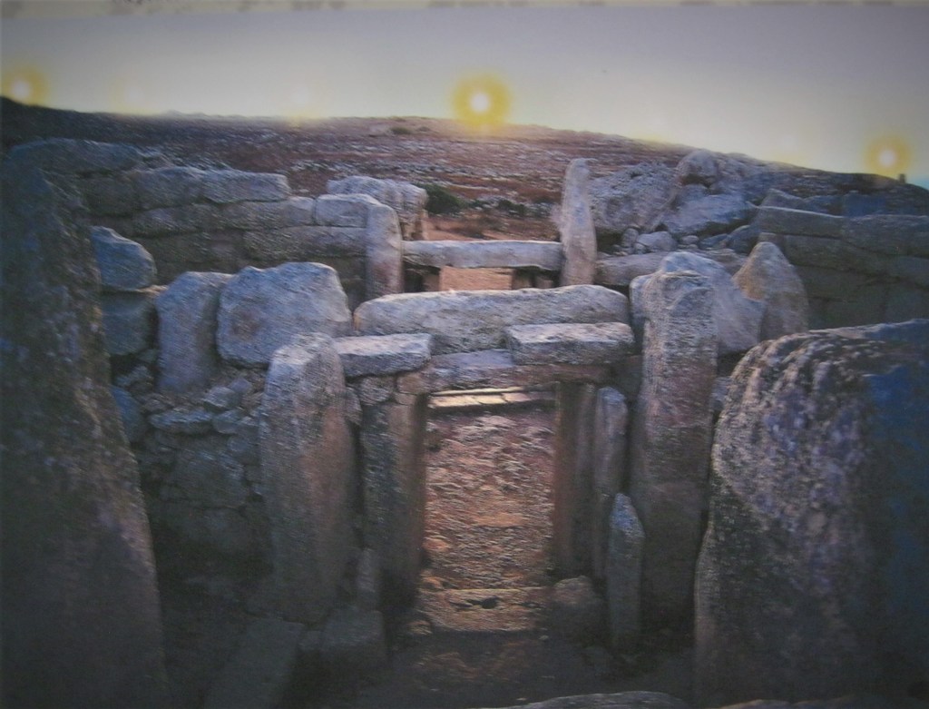
Imaged above and below, at sunrise on the Spring Equinox, (March 21st or 22nd), and the Autumn Equinox, (September 21st or 22nd), the two day in the year wen the length of day and night are equal, the sun is observed rising in line with the very middles of the doorway of ‘South Temple’ of Mnajdra. At sunrise on the Winter Solstice, (December 21st), the shortest day of the year, the sun’s rays light the edge of a large decorated slab to the right of the entrance to the inner apse, whilst on the Summer Solstice, (June 22nd), the longest day of the year, the sun’s rays light up the edge of a similar slab to the left of the same entrance.
Pottery found in the ‘South Temple’ indicate that it was used in the Zebbug time period, (4100 BC). Due to the procession of the earth in that time, solar alignments wouldn’t work. However, researchers claim that it is possible that the ‘South Temple’ of Mnajdra was build to face the Pleiades rather than the Equinox sunrise. At that time, the Pleiades appeared in the same position on the horizon as today’s sunrise. However, the position where a star appears on the horizon changes ever few centuries because of the movement of the earth’s axis due to precession, (if the alignment existed, it is no longer visible).
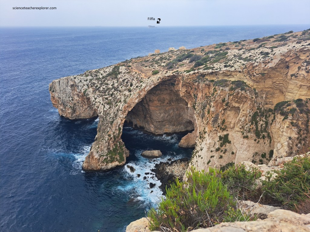
The Maghlaq Fault runs along the southwest coast of Malta and is visible at the foot of the cliff right beneath Mnajdra, (picture above). As a result of this major subsidence, the two rock strata that normally occur at the extreme ends of the ‘layer-cake’ here lie at the same level, with Lower Coralline Limestone on one side (the outer side) and Upper Coralline Limestone on the other. Sitting offshore and lonely on a carpet of blue Mediterranean Sea is Filfla. This tiny island once formed part of the mainland, but a geological fault brought it to its present insularity. Filfla has an area of 2.5 ha, and a circumference of nearly 800m. The 60m cliffs end abruptly in a plateau. The islet is composed almost entirely of Upper Coralline Limestone. Isolated from the mainland, Filfla holds a unique ecosystem with a number of endemic species of flora and fauna thrive there.
