Parowan Gap, UT 2007
In 2007, I was asked by a NASA representative-friend of mine to investigate the Parowan Gap. Apparently, NASA was about to grant money to Archaeologists studying the site. Since I was born and raised there, I was a likely person to report on my findings. There were two Archaeologists studying the site separately: V. Garth Norman (Author of, “The Parowan Gap: Nature’s Perfect Observatory”) and Nowell L. Morris (a renown Archaeoastronomer for Solarnetics, Inc.).
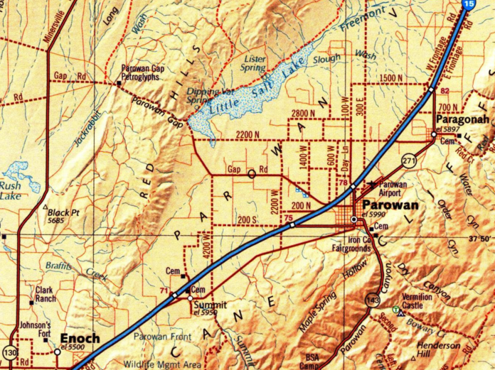
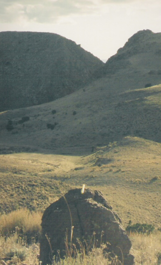
The Parowan Gap is located in southwestern Utah on I-15. While on I-15 going southwest, take Exit 78 (Parowan) and turn toward the town of Parowan into downtown Parowan. While heading south on Main Street, turn west (right) onto 400 North. Drive under the interstate, and continue west for about 17 km until you see a public parking lot, before you drive through the Parowan Gap. Park and walk through the canyon on the road, west of the parking lot (imaged below).
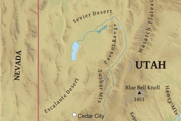
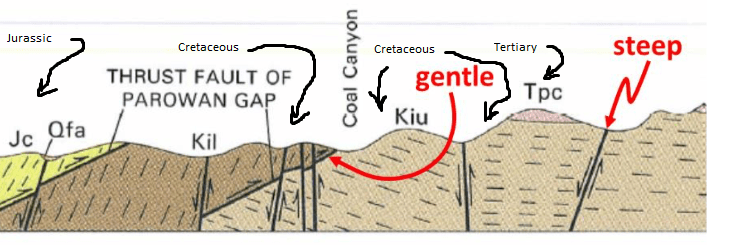
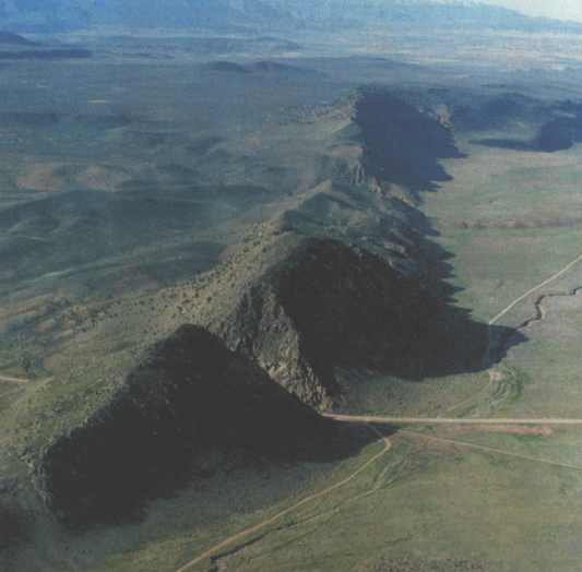
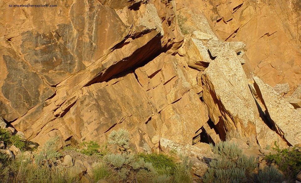
The Parowan Gap is a five-kilometer-long pass transecting the Red Hills between Parowan Valley on the east and northern Cedar Valley on the west. The rock strata exposed within Parowan Gap underwent low-angle thrust faulting and folding between 45 and 100 million years ago during the Sevier orogeny, a mountain-building period caused by dense oceanic crust in the Pacific Ocean colliding with and moving beneath the lighter continental crust of North America.
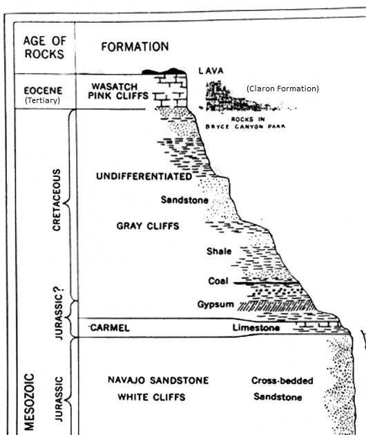
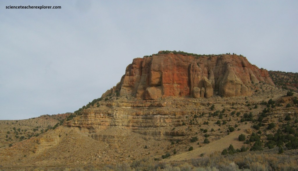
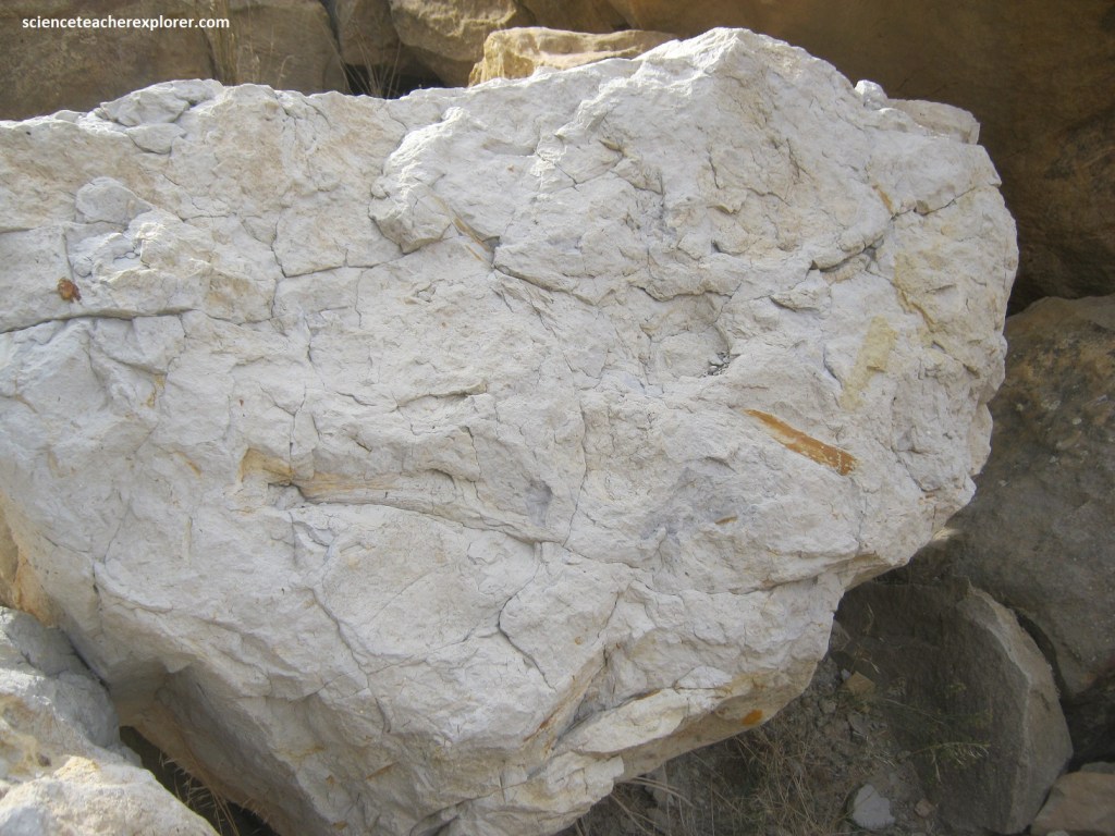
These rock formations include the Jurassic-age Navajo Sandstone and Carmel Formation (on the west side of the Gap), the Late Cretaceous-age Formations, and the early Tertiary-age (Eocene) pink member of the Claron Formation (imaged below).
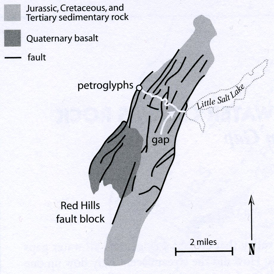
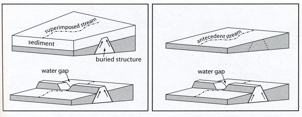
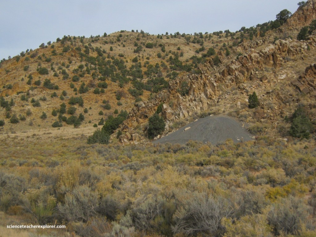
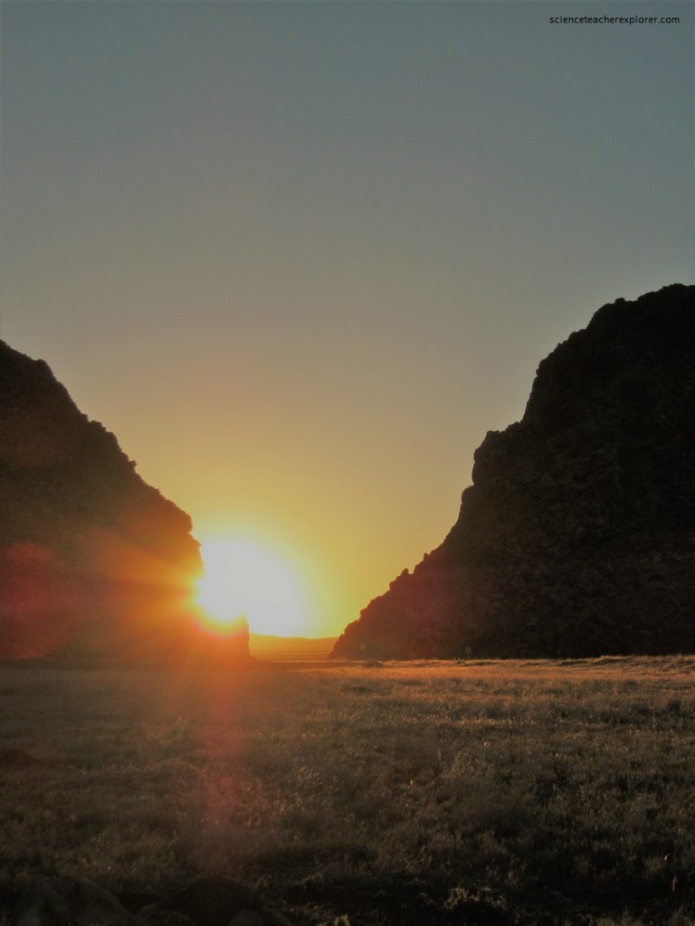
Approximately 15 million years ago, a long slender section of sedimentary rock sheared from the earth’s crust along parallel fault lines (imaged below). This up-thrown block, later named the Red Hills, began to move its way above the surrounding valley floor. At the same time the block was rising, a stream was cutting a path perpendicularly across the ridge. For millions of years the uplifting of the ridge and the down-cutting of the stream remained in equilibrium.
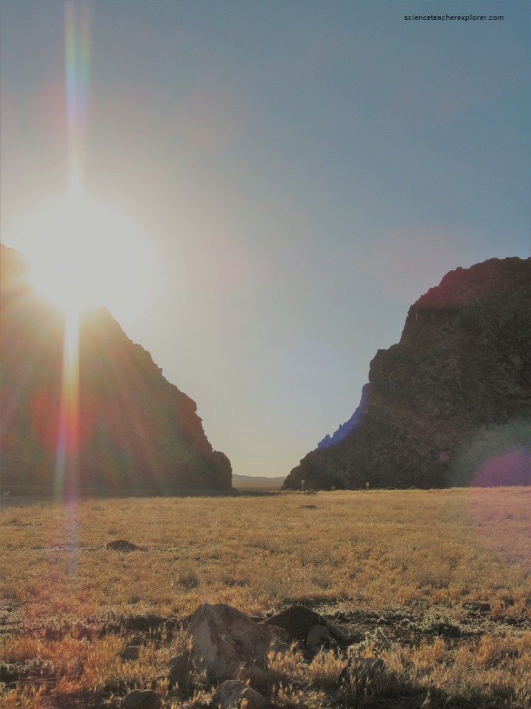
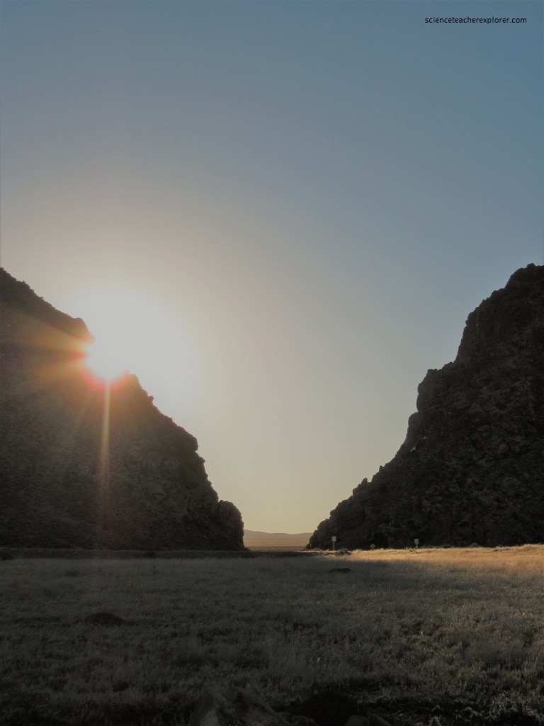
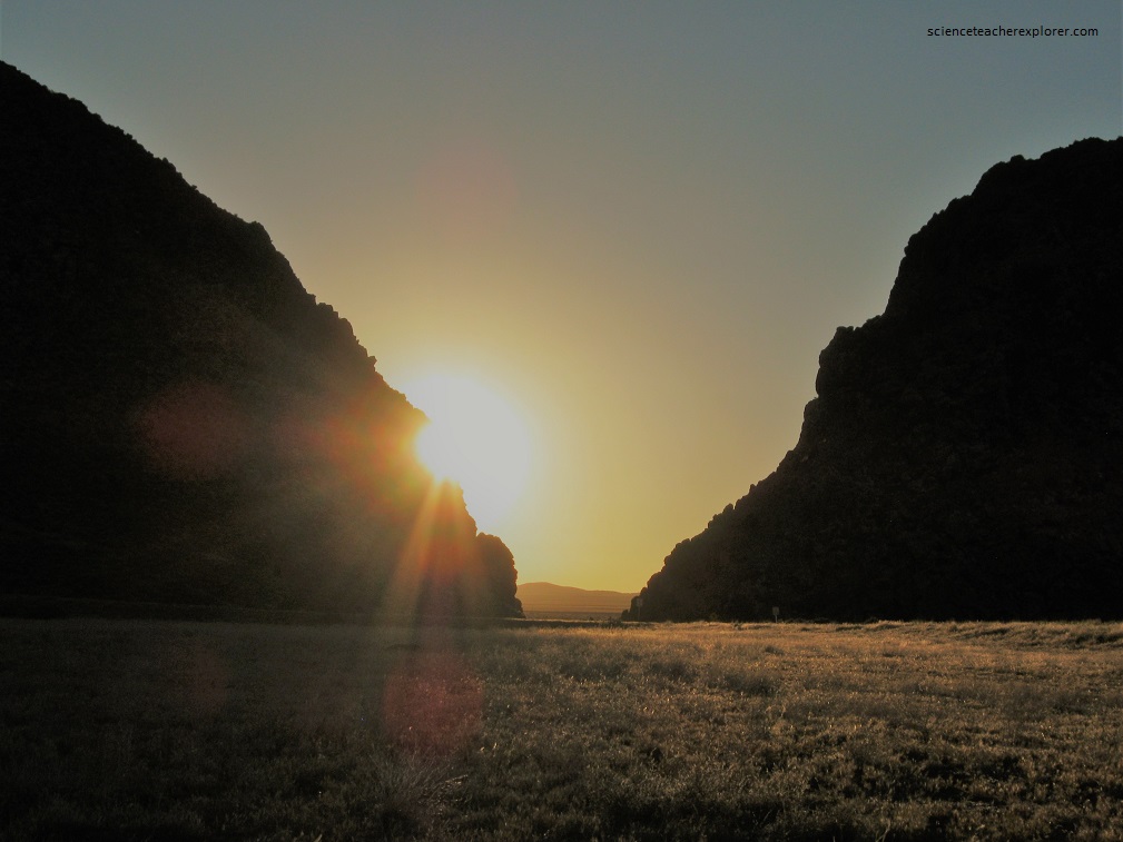
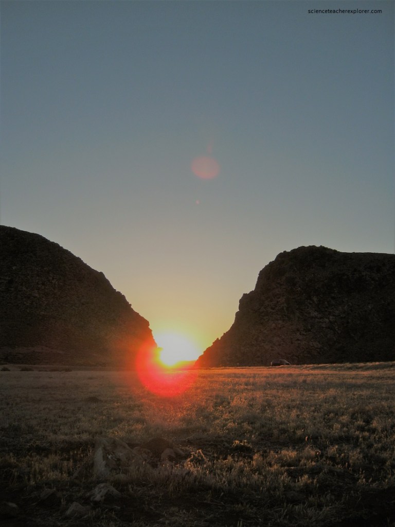
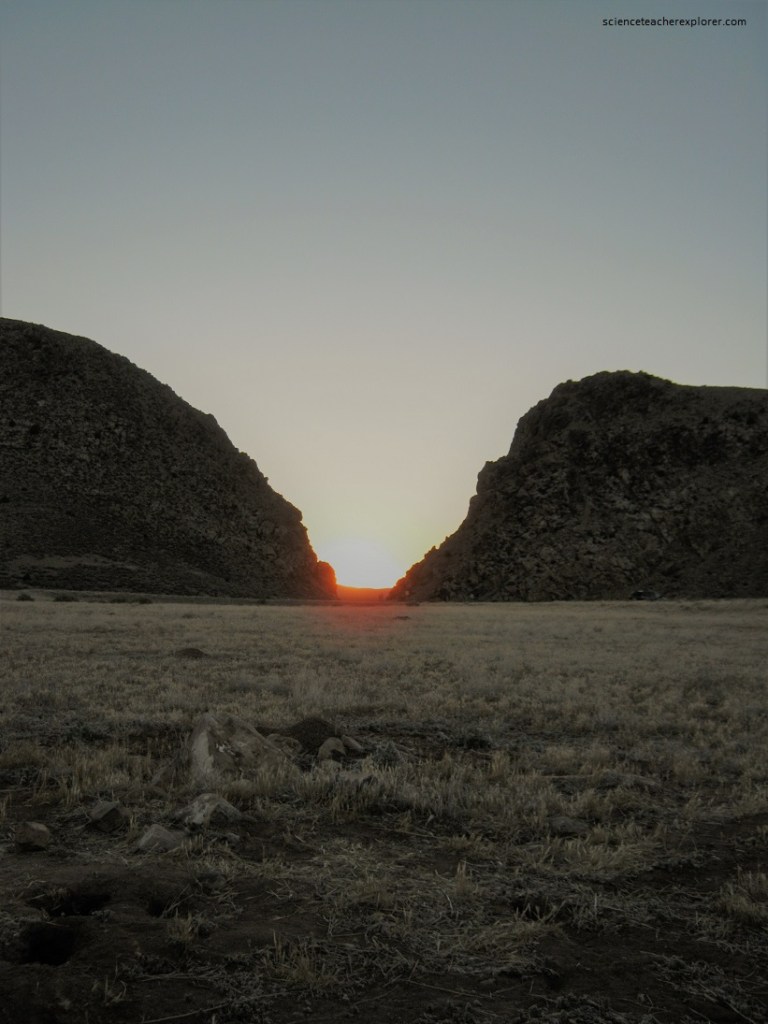
Eventually however, the relentless rise of the ridge and the drying of the region’s climate combined forces to defeat the stream. The stream disappeared and the valley became a waterless wind gap. Continued erosion by wind and rain have shaped the gap, (200m deep) into the pass seen today (pictured below).
Many of the rocks in the gap are a conglomerate, primarily round river rock and volcanic ash. This unique geological history exposed ancient dinosaur tracks and created a canvas for thousands of year of Native American petroglyphs.
As mentioned, hidden among the boulders and rocks in Parowan Gap are fragile footprints in the mud, (65-75 million yrs. ago). Most of the footprints have three toes and resemble giant bird feet. These dinosaurs, known as hadrosaurs, have been nick-named “duck-billed” dinosaurs because of their horny, toothless beaks. In reality they lived very similar lives to the modern cow or buffalo, grazing the plentiful plants and shrubs of the Cretaceous Period.
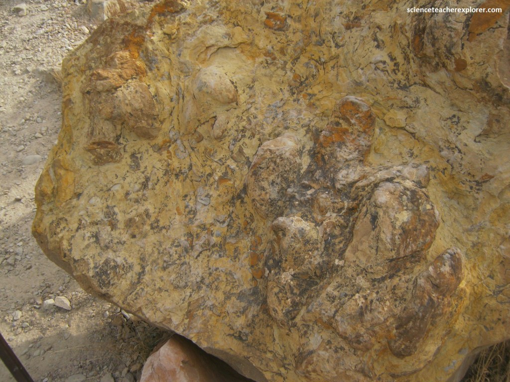
Hadrosaurs were the most plentiful dinosaur species in North America of their time, spending most of their days eating and grazing. Most weighed a few tons and were 3-14m long. They had a thousand small teeth for grinding plant life and a long tail to help them balance. Like other plant-eaters, hadrosaurs were hunted by the meat-eaters and many have been easy targets because they moved slowly. Although they typically grazed on for legs, Paleontologists believe they were capable of clumsily running away from predators on two feet.

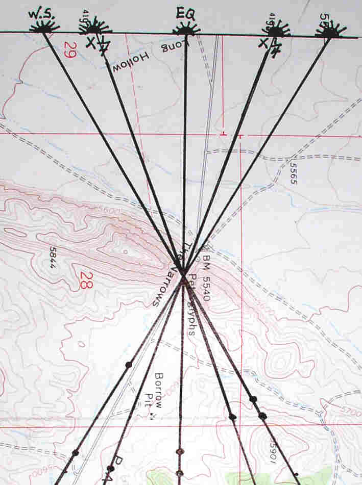
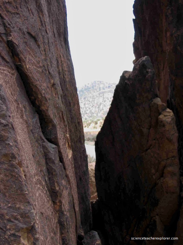
This is called the Narrows of Parowan Gap, the site of many Native-American petroglyphic writings. The valley floor of the large open area just east of the narrows is at an elevation of 5600 feet.
The Parowan Gap Petroglyphs site, managed by the Bureau of Land Management (BLM), is listed on the National Register of Historic Places for its importance as a cultural treasure and is widely recognized for the number and quality of its petroglyphs, with over 90 panels showcasing over 1,500 glyphs.
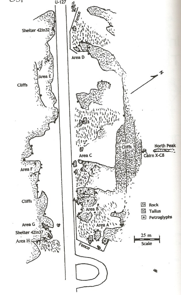
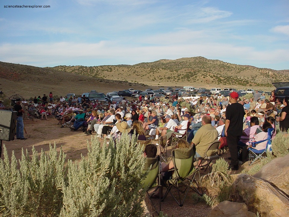
The petroglyphs, pounded into Navajo Sandstone at the narrows, are thought to be the creations of multiple cultural groups over a lengthy period of time, (some glyphs are possibly almost 5,000 years old). To the modern-day Paiute and Hopi Tribes, this is an important historical, cultural, and spiritual site. Therefore, I had the Garrison, Utah Paiute Chief and Nowell L. Morris give a public speech and showing on the Summer Solstice of 2007, (Pictured below on June 21st). I also organized a star party, (20 telescopes), after viewing the sun-down event on the eastern side of the narrows.
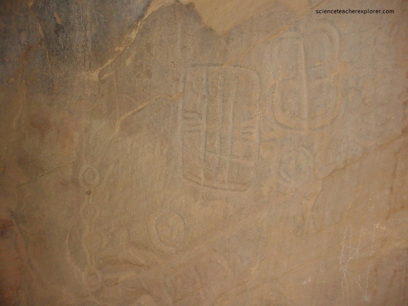
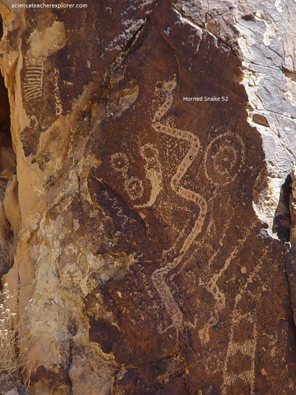
Pictured below, the most interesting feature of this site is a very large and deeply inscribed petroglyph known as the “Zipper”. The archaeologists mentioned above, believed the “Zipper” is a composite map (space) and numerical calendar (time). This rather strange shaped figure looks like a very large “V” with a lobe at the vertex. Along both branches of the “V” are many tick marks giving its’ lines a zipper like appearance.
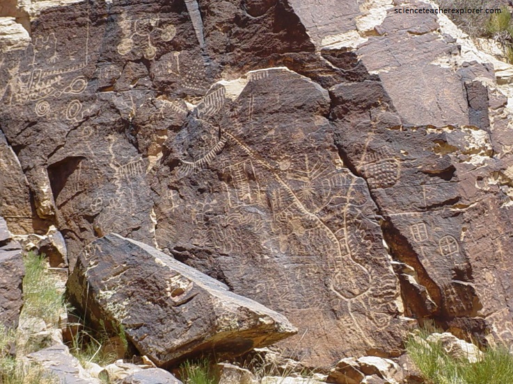
There are 44 tick marks on the right starting at the bottom of the lobe and counting up both sides of the line to the end of the line. There are 90 tick marks on the left side of the “V” starting low on the lobe and counting up both sides to the point of bifurcation. There are 23 ticks along the appended bough and 23 more above the bough as the left branch of the “V” continues up and across a large crack in the rock surface. The total comes out fairly close to 180 and is very close to 1/2 year or the number of days required for the sun to traverse the horizon from solstice to solstice, (pictured below).
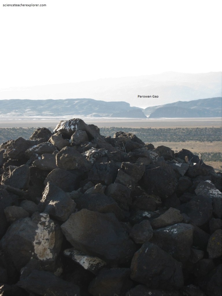
After studying the Zipper Glyph since the late 1990s, Nowell L. Morris determined that the narrow neck of the Zipper Glyph represents the narrows of the Gap. With the help of Garth Norman, they determined that the lobe of the Zipper Glyph represents the valley just east of the narrows. As Garth Norman studied the lobe of the Zipper Glyph, he noticed that it was a map for markers found within the eastern valley. He discovered Cairns (rock piles) were set in positions in the valleys on the east and west side of the Gap Narrows by the Fremont about a thousand years ago to watch sunrises and sunsets on specific calendar cycle dates. These topographical correspondences made a strong case for the map-calendar interpretation, (imaged below).
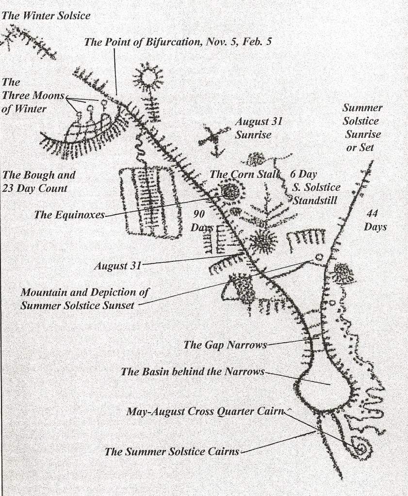
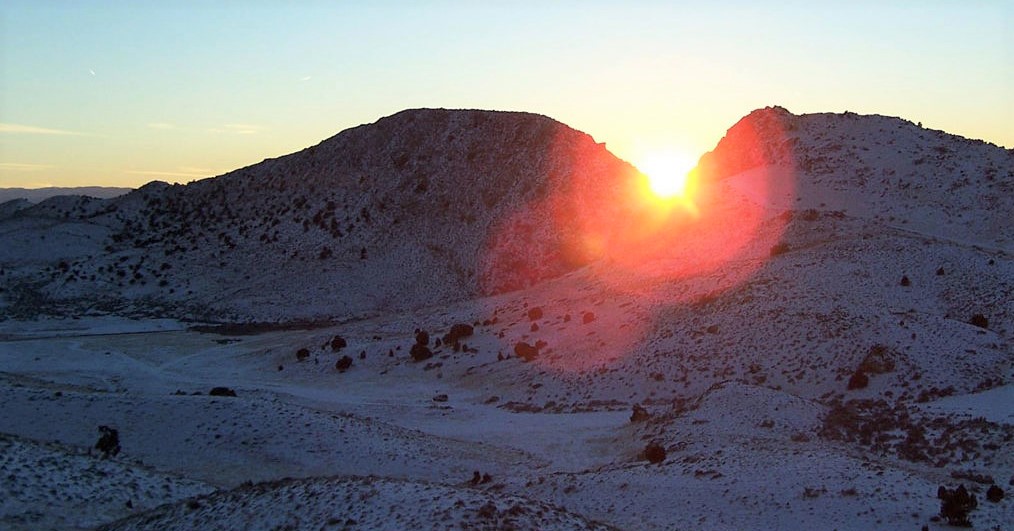
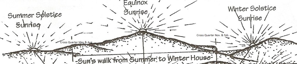
Imaged below, five primary sun dates begin the year in the north at summer solstice sunset and move south in six months to winter solstice sunset. Because of the earth’s tilt, the sun appears to reverse its path moving back north to summer solstice. According to V. Garth Norman, “this annual Sun transit is observed through the Gap from cairn observatory stations east of the Gap Narrows to the west”. “These sunset movement patterns follow the list below—winter to summer solstice sunset observations move south (1-2-3-4-5), then back north form summer to winter solstice (5-4-3-2-1).
- Summer Solstice {June 21st = 182.5 days (1/2 year)}
- Summer Cross-Quarter {Aug. 5 & May 5 = 45 days (1/8 year)}
- Equinox {September 20 & March 21 = 91 days (1/4 year)}
- Winter Cross-Quarter {Nov. 5 & Feb. 5 =45 days (1/8 year)}
- Winter Solstice {December 21st = 182.5 days (1/2 year)}
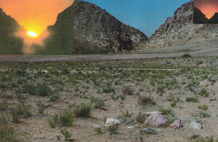
Pictured below, was a string of photos taken from behind the Summer Solstice Cairn in the valley during sunset of the day after the Summer Solstice of June 22nd, 2007. (I did this to avoid the crowd and the sun was a little off toward the south mark)
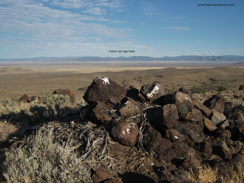
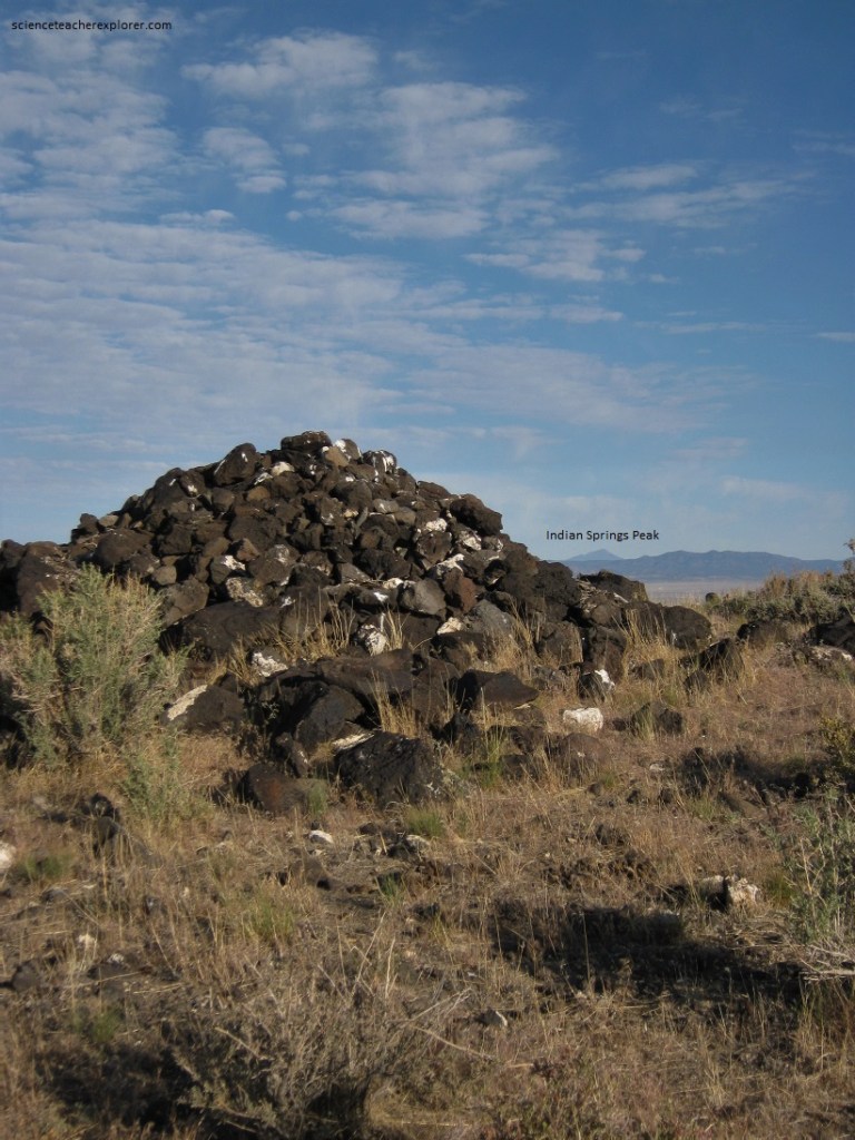
The next day, (June 23rd) I decided to extend the line on the map towards the east and west to see what it would hit. Interestingly, the east-line crossed through the Center of Parowan City, (location of the old Paiute Village before the arrival of the Mormon Pioneers). And the west-line crossed over Indian Spring Peak near the Utah-Nevada border. I decided to follow the west-line on foot to see if I could discover additional Cairns. I discovered three Cairns in the desert. Later, I climbed Indian Springs Peak to find no Cairns. I was greatly disappointed.
Of course, other Cairn alignments should be mentioned at the Parowan Gap. Pictured below is the Equinox Cairn alignment for sunset.
Then the Winter Solstice Boulder at sunset.
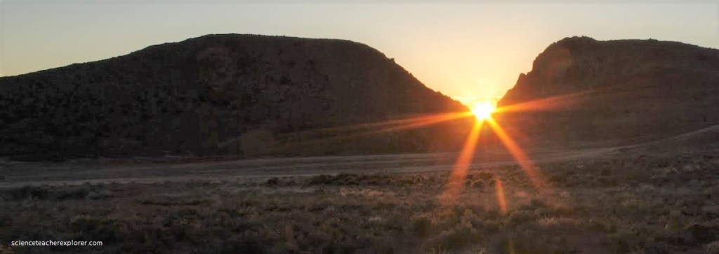
Then in 2024; a time lapse photo of this location was posted by John Lundwall:
To the Pre-Columbian peoples, the sun was a basketball sized sphere of fire. It flew just over head and always out of reach. And while the sun was one of the most powerful of cosmic entities, he was not beyond being influenced and controlled. The sun, the moon and the earth were in constant interaction where their personalities could be in conflict and competition. Therefore it was important that the ancients watch over these entities. Pictured below, Nowell L. Morris provided a drawing of the eastern horizon as seen from the Zipper Glyph. He had designated the traverse of the sunrises between the cross quarters. This is the sun’s walk between his two houses. Where the day count leaves and enters the two houses, become the two major points of division on the glyph.
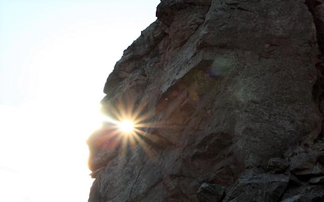
As viewed from inside the Gap Narrows, there is the profile of a stone face, (pictured below). Nowell Morris explained to me that this is the Paiute God symbol called “Tobats”. Pictured below in profile, Tobats is the Stone Face that lives in the Gap. In order to see Tobats, we entered the Narrows and then positioned ourselves 1/3 of the way through the Narrows from the east end. From that point, Mr. Morris had me look up on the south side of a large protruding rock, with me facing east. There was a deep crack in the rock above the larger cave. This was Tobat’s mouth. He also had lips, jaw, chin, nose and eye (pictured below).
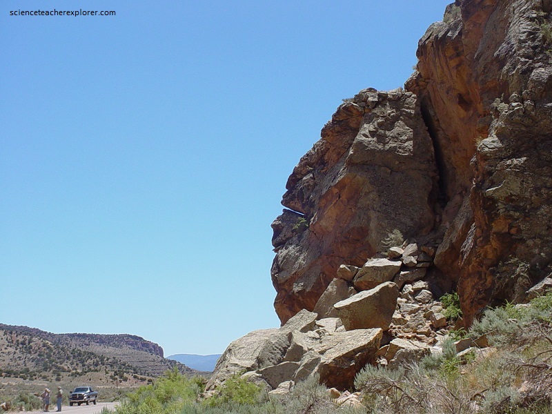
On the first day of the Fremont Winter, (November 5th), the sun rises at 7:49 A.M. in the cross quarter notch and proceeds to pass through Tobats mouth at 9:00 A.M. (pictured below). (It should be noted that at the Summer Solstice sunset cairn places the course of the sun over Tobats’ head and the actual set is in his face).
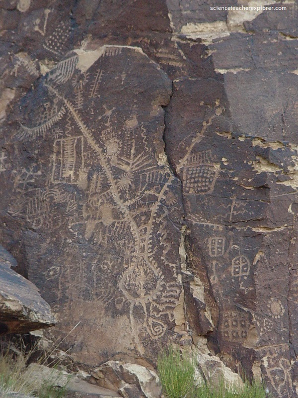
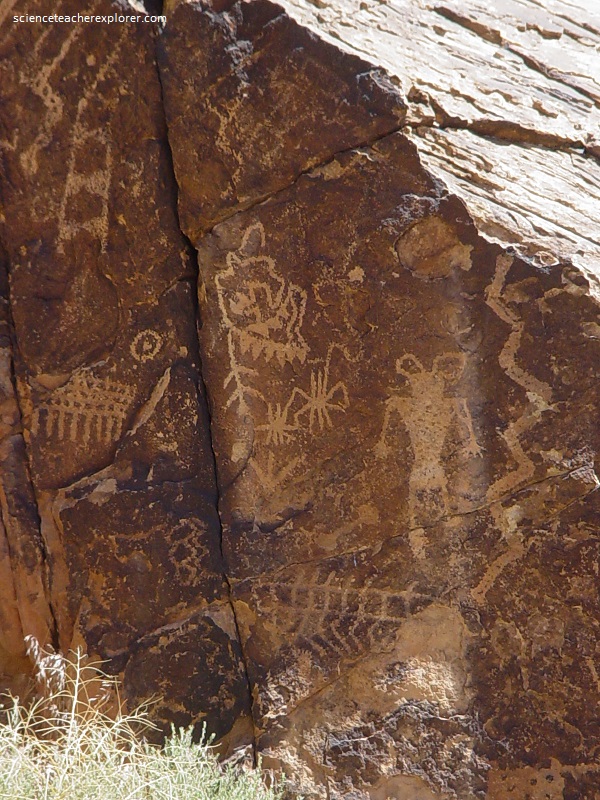
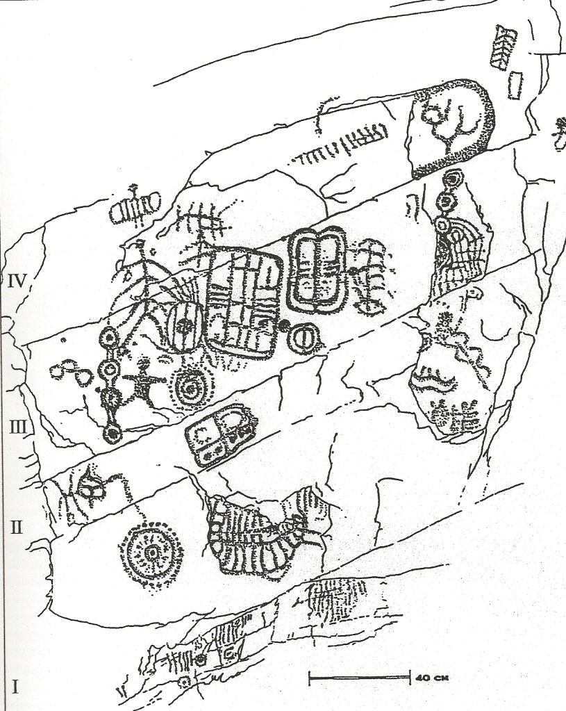
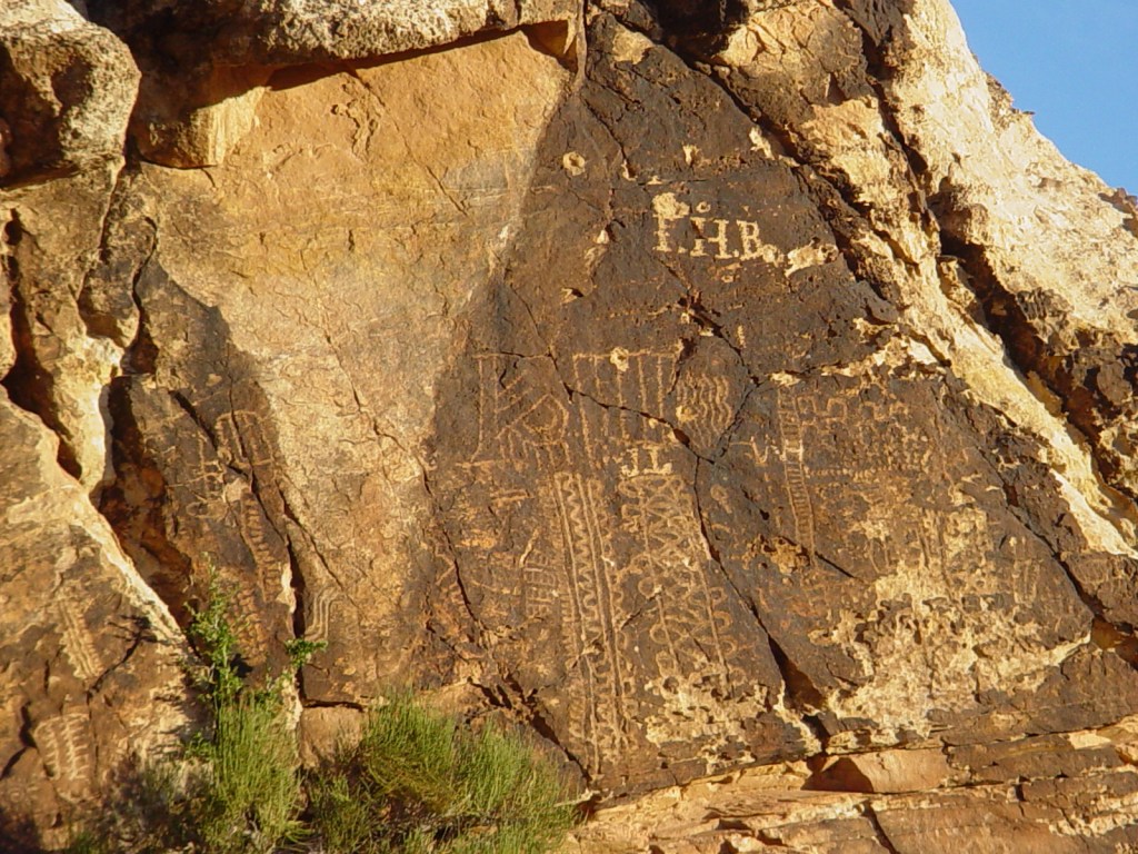
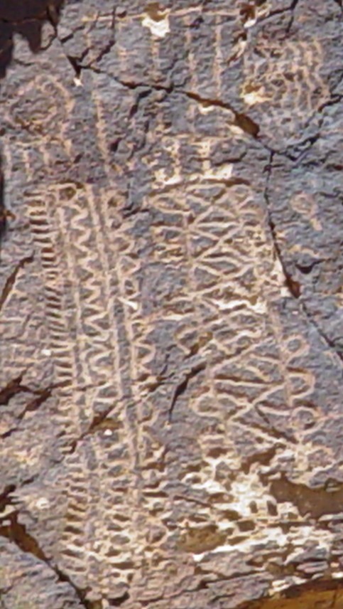
On a panel behind and left of the Zipper Glyph are very detailed and neatly inscribed glyphs (Area B on the map). They are neatly pecked geometric figures: zigzag lines, triangles, arcs and circles. There is also what looks like a bear foot with various lines around it to make it look like an owl. There are many petroglyph numbers on the panel of dots lines and zigzags. This is the Lunar Calendar Panel, (pictured below).
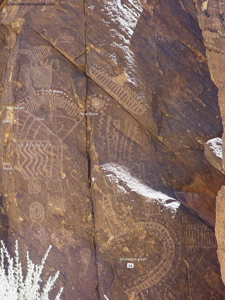
Pictured above, the owl is a symbol of the night and the bear hibernates through the winter season symbol of the “night” time of the year. The owl’s head is shaped from an 11 comb + one line overhead totaling a year count. Add 3 lines on the owl’s beak to total 15 for a full moon count, which may also symbolize the three moon month seasons. Four wavy lines to the left of the body suggest flying motion of the wings through four seasons.
Also pictured above, the fan below the owl has 29-day lines. The fan is an actual picture of the moon’s traverse across the sky from new moon in the west to full moon overhead, to last crescent moon in the east. The section below the fan has a 6-comb (6 months) and 4-ladder (4 seasons) and 3-space (3 month quarter).
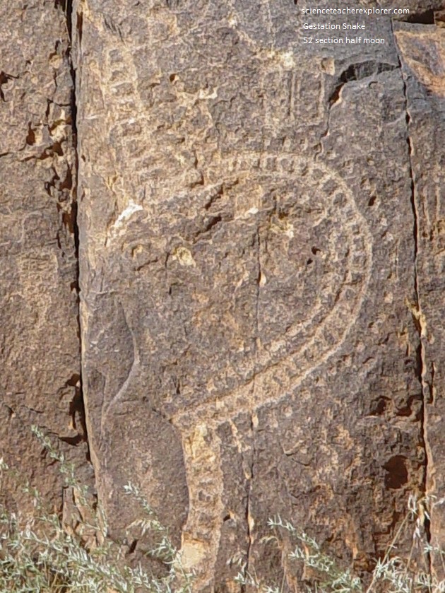
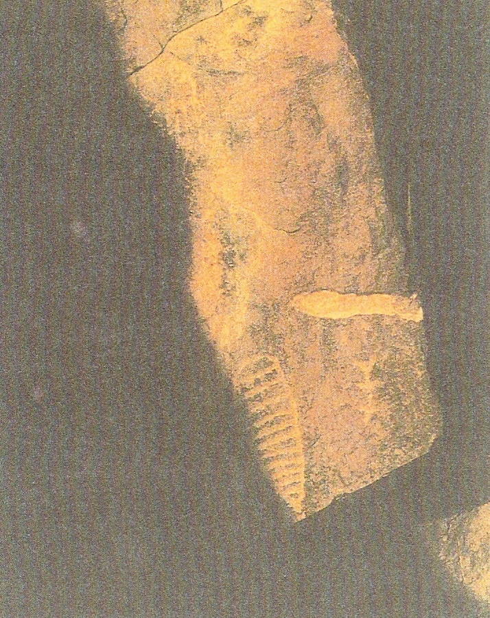
Pictured above, a large U-shaped (pregnant) serpent at the lower right has 52 count body sections on it’s body which relates to the 260-day fertility gestation cycle (9 lunar months).
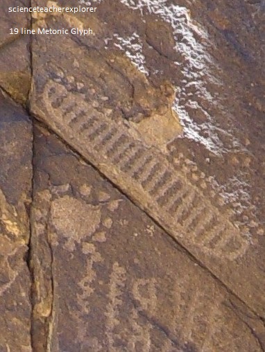
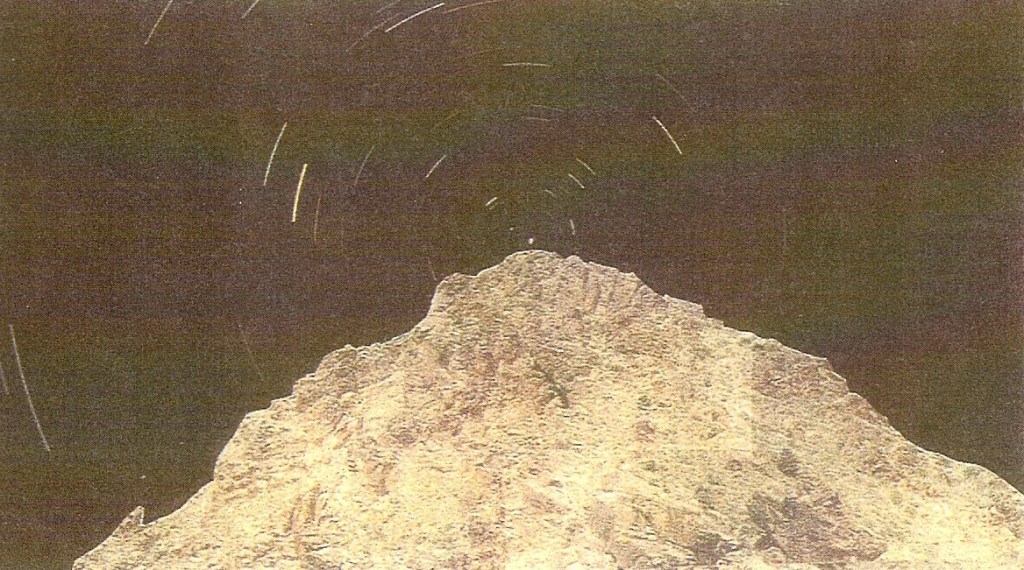
Pictured above, just above the 12 lunation year-glyph is a very well done 19 teeth smile glyph. It runs along a prominent crack in the rock surface. On summer solstice, June 21, 2005, the moon rose at its southern extreme standstill and illuminated this smile with a shadow line around it’s left side and bottom. This occurs once every 18.6 years in the moon’s Metonic cycle. The upper right 19-step ladder (nearest whole number to 18.6) records this cycle and points toward the a circle behind the boulder (pictured below). The next viewing of the southern extreme standstill of the Moon, at this site, is on June 21, 2024 at 9:54 P.M. (pictured below).
Pictured below is the spider pertoglyph. According to Garth Norman, this panel is a map of the peaks of the Red Hills with six legs matching the slope ridges most visible with melting winter snow. The strange squiggly line at the top of the panel is of a map of the Red Hills north hunting trails, a gap south pass hills, and a basin south pass and ridges. The two spider-like figures are the south Red Hills ridges. The humanoid figure is of the sacred “Spider Woman” with antennae that are spider like antennae. On the right is a “Sun Serpent” that has 45 dots that equal the 45 days from May 5-August 5 Cross-Quarters count to solstice. The combs on the left and bottom are lunar counts.
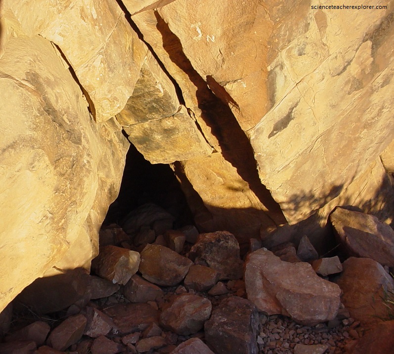
Across the road (south) from the Zipper Glyph are two caves. One is named the “Big” Cave and the other the “Small” Cave (pictured below).
The “Big Cave” shelter with its many petroglyphs functioned as a ritual shrine spanning millennia within the extensive Narrows petroglyph archive. This discovery came to light during the ten year archeological project (1993-2003) involving field survey, excavation, petroglyph recording, archaeo-astronomy , and comparative ethnography (traditions) research.
Pictured above and below, the large panel is composed around a large central box sectioned with a variety of number combinations to possibly encode the full calendar system with a probable new year date. Mr. Norman interpreted the man at the left center with outstretched arms and legs as the shaman recording his astronomical observations on this panel and directing its inspection, so the narrative logically starts with him. His pointing arms and left leg tie two cross-quarter circles in a 4 chain (2×45=90) to a 3 concentric circle with 30 dots for a 3 month quarter (3×30=90). The man’s left arm also points across the 4 chain to 3 moon circles for another quarter sign. His right leg points to a quartered box containing a crescent moon, sun, 2 dots and 3 dots, all tools for cross-quarter and quarter season observation.
Imaged above, figures above the shaman and to the right move into the sky realm with spirit figures for recording the astronomical cycles. The left circles chain has an ascending motion above the shaman from the stick man to a winged figure at the top. The stick “spider” man (8 limbs) rises off the top sun on the chain, which should be ascent at summer solstice on this northern side. So, this 4 circle chain pictures the four 45 day cross-quarter periods from winter solstice at the bottom to summer cross-quarter top circle (May 4-June 21) for the summer growing season.
Pictured above, inside this Small Cave, Fremont artifacts were found and petroglyphs on the top and back wall. Lithic flakes and bone were also found throughout, which enabled C-14 dating. At a depth of 45 cm, a charcoal sample gave a C-14 date back nearly 5,000 years. So the petroglyphs could be pre-Fremont, (1,300 years ago). However, the most interesting part of this cave is that sunrise petroglyph interactions from two observatory gnomons inside the cave clinch both the summer solstice and 260-105 day summer season celebrations. For example, a sunlight dagger tip settles perfectly into a small petroglyph wedge on April 29-30 at the end of the cosmic circle and spiral petroglyphs to celebrate completion of the spring birth season. The light dagger returns again to its wedge on August 12-13 at the end of the 105 day summer growing season to initiate the 260 day fertility gestation cycle which goes to winter solstice and back to complete another birth cycle the next spring on April 29th.
At the Parowan Gap Site, Shadow-Marker Petroglyphs were pecked for strategic viewing and sighting on rock cliffs inside the Narrows to record the same date as the Cairns. For instance, pictured above, on April 29th, as the sun rises, the shadow crosses the cocoon and bends into a pointer at the 8th step where the 105 day summer season starts and then concludes on the sun’s return date of August 12th. These are the only day in the year when this figure is fully illuminated at sunrise.
Pictured above, the double horned serpent body is composed to portray the calendar cycles in day-count circles on six body sections (6 month solar transit), centered on a 4 quarter concentric sun that interacts with a summer solstice sunset shadow marker. The top five turns have a 45 day cross-quarter count (summer cross-quarter to summer solstice). The 52 total is the day count from April 29th (New Year) to June 21st summer solstice of the 260-105 day calendar. The bold tail with 7 concentric circles is a base calendar plot number (7×52=364) that originates from a lunar quarter.
Pictured above, this large panel facing east on a high ledge above the cave shelters is ideally suited as an eastern horizon observatory lookout. Focus on the weave panel. Venus has similar maximum and minimum cycles as does the moon, and a much more unpredictable weaving pattern. This led Mr. Norman to suspect the adjacent vertical glyph with its erratic weave was an attempt to track the shifting Venus risings and Moon risings along the eastern horizon. The Venus star rises in the east just before the sun during its Morning Star phase. Venus goes through three major phase shifts before returning as Morning Star after a short disappearance.
Pictured above, a large 6 comb for a half year hovers directly over the Venus glyph with its left tooth attached to a line count of 15 circles (half lunation) below at the side of the moon glyph. The Venus glyph has 8 circles (solar transits) on the each side to define its 8 year cycle. Five Venus cross (X) glyphs down the middle weave represents 5 Venus cycles of 584 days each (5×584=2,920 days). [Note: 243 days of Morning Star visibility + 77 days of dark + 252 days of Evening Star + 12 days of Invisible days that return to Morning Star heliacal rise = 584 Total days of the complete Venus Cycle]. A long lunar ladder to the right has 25 steps with a detached larger ladder below with 4 steps for a total of 29. Two wavy moon count paths extend right from the top of the ladder. This ties to a section of 5 rows of dot counts. The dot totals are 70. Added to the ladder, 70 + 29 = 99. Therefore, the conjunction totals for Venus, sun and moon are: Venus (584 x 5=2929 days), Sun (365 x 8 = 2920 days), Moon month (29.5 x 99 = 2929.5 days). Amazing!
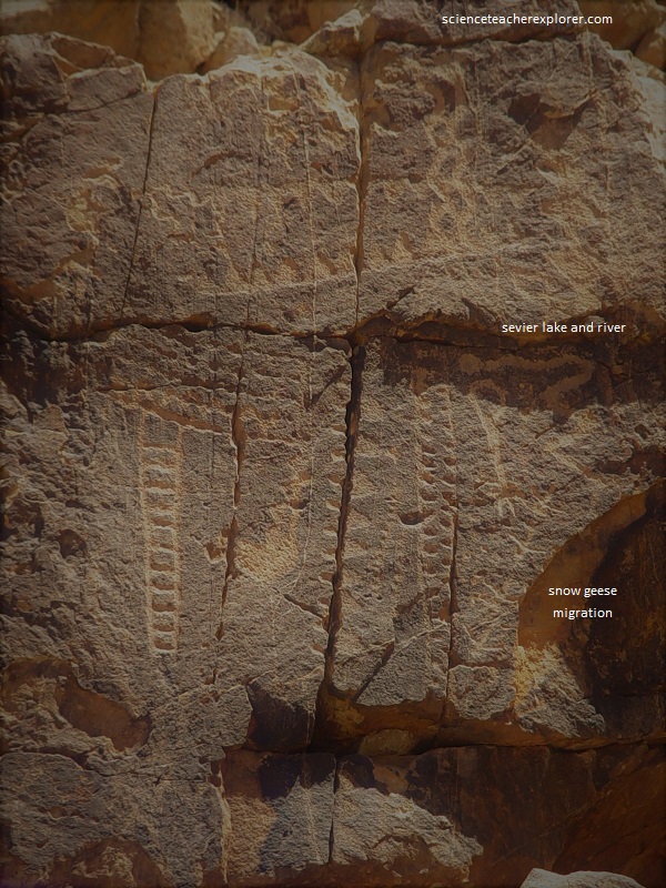
Pictured above, the lower right section of the above panel, pictures a dramatic life cycle miracle at the Gap. Four geese are pictured flying in their northward migratory flight. [Annually 30,000 Snow Geese fly north over the Gap to the Delta marsh lakes in Utah during the last two weeks of February]. On the panel, these four geese are pictured flying up toward a serpent trail. Locals recognize this snake above the geese as the Sevier River, bending back on its course to Sevier Lake, which is wide at the top and narrow on the south end. The Circle and bird-track trail extending down from the serpent trail head matches Wah Wah Valley due south of Sevier Lake to Sulphur Springs at Lund in the Escalante Desert where trails fork into 4 directions like birds toes.