Jasper N.P., Alberta
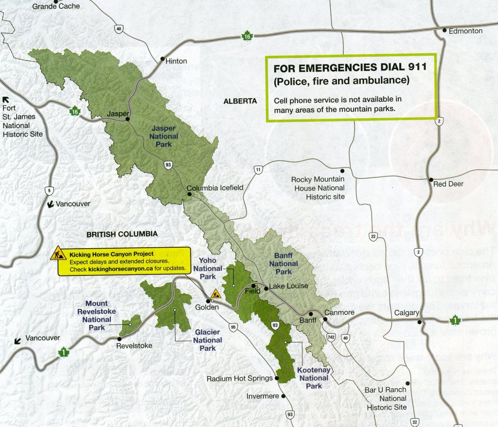
During August of 2022, my wife (Becky) and I took a road trip to explore some of the National Parks of Canada. Our first couple of days were spent in Jasper National Park of Alberta Canada. Jasper National Park is situated 370 km west of Edmonton and 404 km northwest of Calgary. Jasper National Park is an area of spectacular scenery, stretching for 209 km along the eastern slope of the Rocky Mountains from their western spine, along the British Columbia/Alberta boundary, eastward to the foothills. Its size, some 10,878 square kilometers the world; and its location, astride the parallel ranges of the Rocky Mountain System, makes it one of the most beautiful.
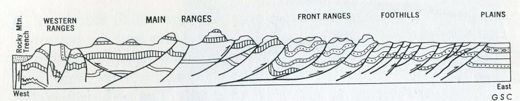
The mountain ranges along the northeastern boundary of the park are cut into rocks of great complexity of structure so that individual peaks commonly show sweeping folds and great fractures. Mountains along the park’s central ribs are cut into uplifted masses or horizontal or gently fold sedimentary rocks so that individual peaks are commonly and clearly made up of flat or gently dipping layers. Amid the mountains lie beautiful alpine valleys with rushing streams and sparkling lakes.
We started from Calgary and headed west through Banff National Park and then north on Route 93. Stretching 232 km between Lake Louise and the town of Jasper, the Icefields Parkway (Highway 93) travels through the heart of the Banff and Jasper National Parks.
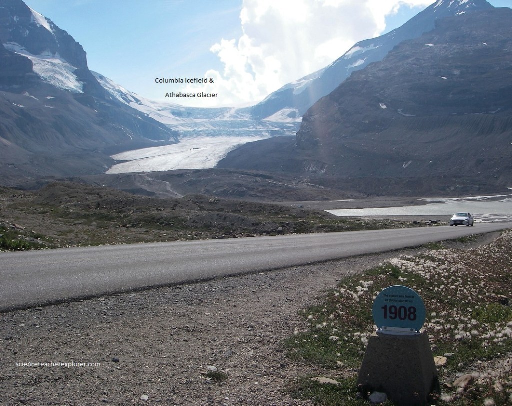
Our first place to explore was the Columbia Icefield. Imaged above, the Columbia Icefield is an area of some 389 square kilometers of glacial ice and snow astride the Continental Divide at the southern end of Jasper National Park and adjacent parts of Banff National Park and Hamber Provincial Park of British Columbia.
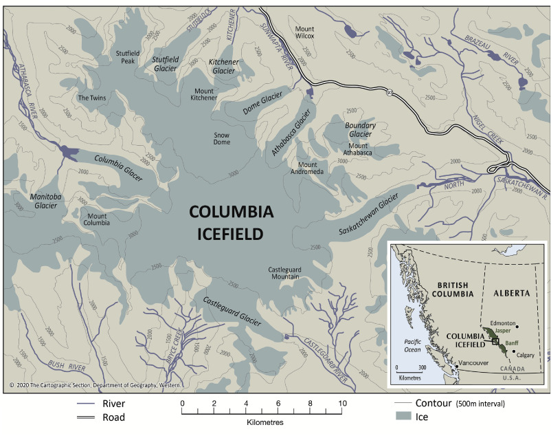
Tongues of the ice from the Columbia Icefield move down three principal valleys, as the Athabasca Glacier to the north east, the Saskatchewan Glacier to the east, and the Columbia Glacier to the northwest. Numerous other small outlets from the central reservoir spill over into the surrounding valleys.
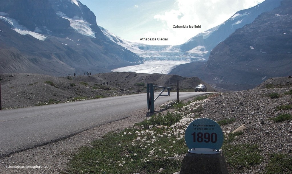
Pictured above, a superb view of mountains and glaciers is presented from the Columbia Icefield parking area. To the west and southwest a great tongue of ice, the Athabasca Glacier, issues from the Columbia Icefield over three great icefalls which appear like terraces at its back. To the left, a very sharp ridge stands high above the surface of the present ice. This represents an accumulation of debris that was scraped and pushed along the side of the Athabasca Glacier when it was much larger than it is now (2022). Irregular mounds of debris in the foreground also tell of its once-greater extent. Some believe this to have been at the most recent ice maximum, which took place about 1890. Since then the melting has been greater than the addition of ice from the back so that the glacier has gradually shrunk from these marginal and terminal ridges to its present position.
Pictured above, the main tongue of ice fills a great trough-shaped valley to a depth of about 300m over some of its length, with a gradual thinning toward the end or the foot of the glacier. The glacier is wider than it looks in the lower reaches, for extends underneath the dark rubble-covered areas on each side. The waste-covered area is especially wide on the north side.
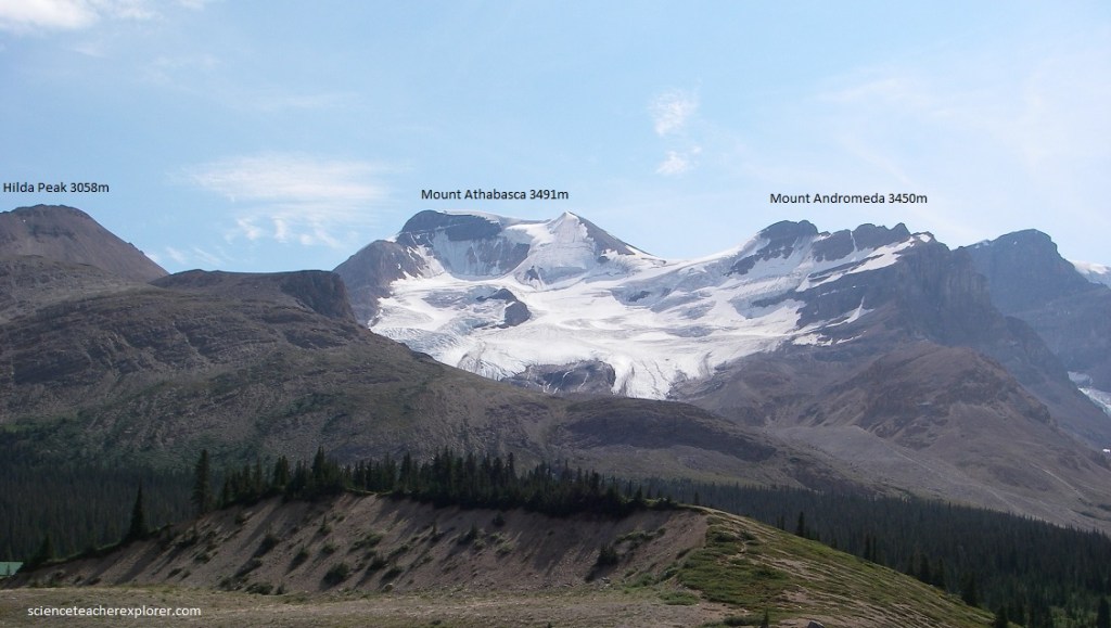
Pictured above, to the south of Athabasca Glacier, Mount Athabasca dominate the scene, and from the its snowy shoulder it sends a glacier into a valley that is partly hidden by the shoulder of an intermediate mountain. All the mountains in the view to the west and southwest (pictured above) are carved in sedimentary rocks of Cambrian age. The axial or central part of an upfold, or anticline, crosses the upfold, or anticline, crosses the region about halfway back along the Athabasca Glacier and Dome valleys. Thus, at the backs of these valleys the rocks are dipping gently away from the parking lot and in the nearer parts of the valley they are dipping gently towards the parking lot. {It is interesting to note that the two valley-side glacial masses on the south side of the Athabasca Glacier continued all the way down to the main glacier a very decades ago. With increase wastage due to a warming climate, they are now left hanging on the sides with piles of mixed rock rubble and ice in cones below them}.
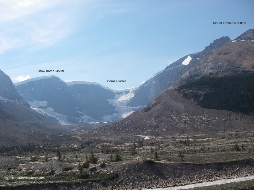
Pictured above, the Columbia Icefield can be seen rimming the mountains farther to the north. In the main valley to the north, Dome Glacier is formed by the refreezing together of reconstitution of ice and snow which fall over the cliff at the back of the valley. In the bottom of this valley a great mass of rock waste, tongues of ice, meltwater streams, and sharp-ridged lateral moraines can clearly be seen. These hills to the north and east of the parking lot lie close to the center or axial part of a downfold or syncline. The relationship means that younger rocks appear in the hells back of the parking lot and older older rocks in the mountains across the valley.
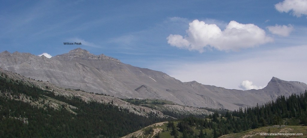
Pictured above, a superb scree or talus slope lies on the flank of Wilcox Peak to the northeast, and because it accumulates by the falling of debris from above, its boulders provide a complete sampling of the rocks in the upper parts of the mountain. The profile of Wilcox Peak shows a very steep wall on the side, (the result of cutting by glaciers that filled the valley).
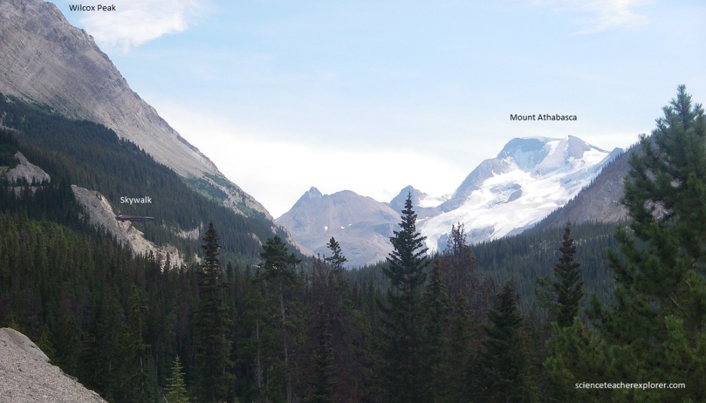
Pictured above, the Sunwapta River valley bottom and above it to the foot of the foot of the ice of Athabasca Glacier itself, is choked with glacial debris left there by the glaciers or washed into it by meltwaters in the time since they retreated. As the photo above looks southward up the valley, the snow-covered from this point, the snow-covered peak of Mount Athabasca dominates the skyline. The glacier which it sends down its northward face has several beautiful icefalls on it. It gives the impression of being a thin veneer of ice draped over the rounded rock surfaces, and this confirmed in the lower regions where several “bosses” of rock show through the ice. Beyond that, Mount Athabasca shows three glaciers with icefalls, snowfields in their heads, and great cracks or “bergschrund” showing high up where the snow and ice have started to pull away from the steep back walls.
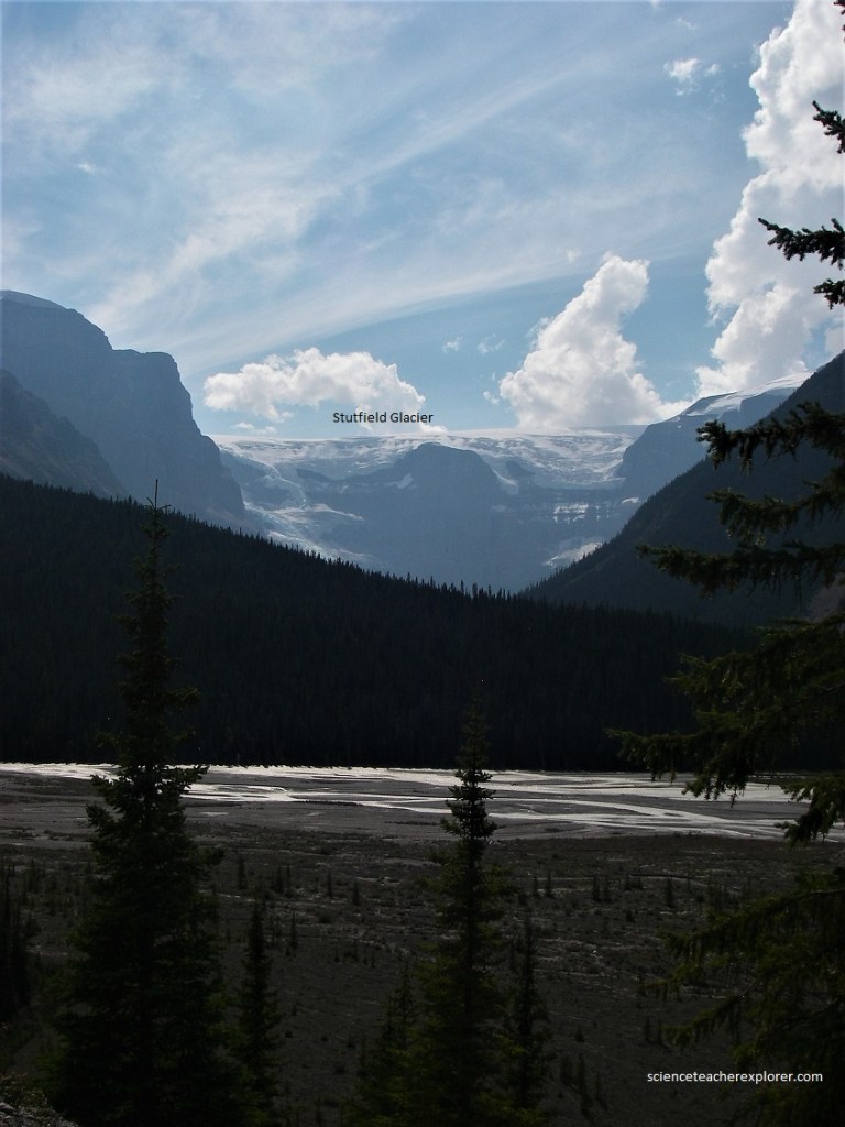
Pictured above, a good example of a braided river flat, (a valley bottom filled with sand and gravel with a river spread across it in interlacing channels. Glimpses of the Columbia Icefield can be seen along the edges of the mountains. A superb double set of icefalls occurs on the steep back wall of Stutfield Glacier. Most of the main glacier in the bottom, made by reconstitution of broken ice below the icefalls, is hidden by the intervening wooded ridge. Mount Kitchener is to the left of Stutfield Glacier and shows the edge of the Columbia Icefield in cross section all along its crest, like the icing on a cake. High on the shoulder of the mountain, a bowl-shaped depression or “cirque”, formed by glacial cutting, lies close enough to the edge so that its terminal moraine material has poured over the shoulder of the mountain to make a tall scree slope.
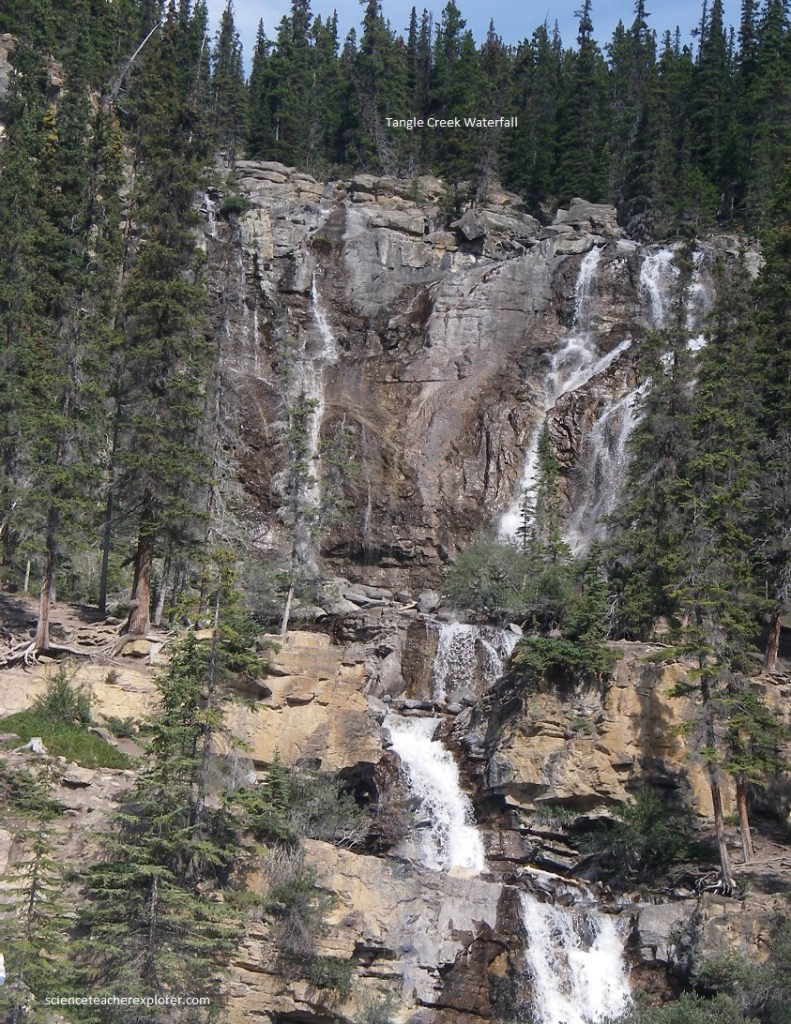
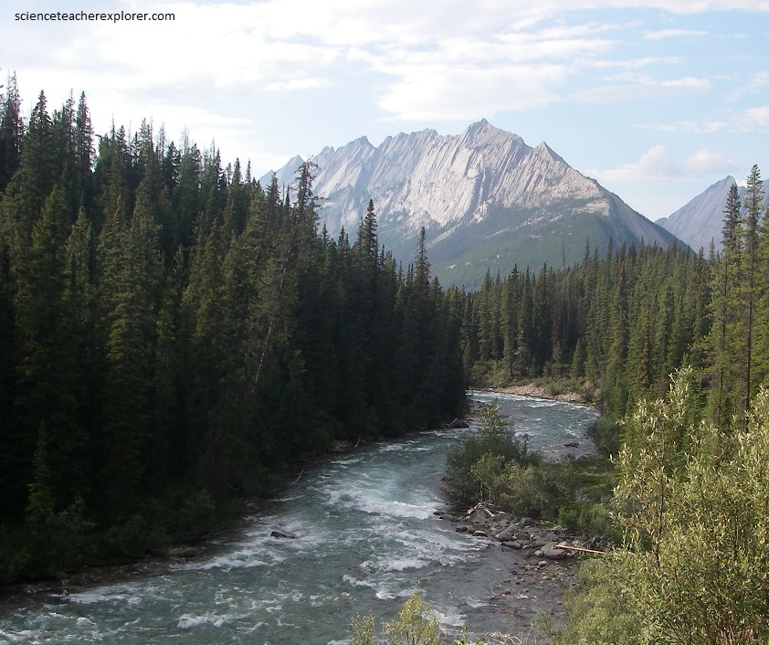
Pictured above, Beauty Creek is a fast-flowing mountain stream which rises in the valley behind Tangle Ridge, then falls precipitously to the level of the Sunwapta River. The above photo shows a deep canyon cut in limestone, with numerous waterfalls, one after another. The massive grey limestone in the base is of middle Cambrian age and the upper slopes are upper Cambrian and Ordovician rocks. One rock bed, well up the mountain, makes a distinctive brownish scree slope and is topped by more massive, spiky, flat-lying limestone.
Pictured below, across the Sunwapta River Valley lies a mass of jagged peaks cut into thick-bedded, nearly flat, sedimentary rocks which lie close to the axis of the syncline or downfold passing all along the Valley.
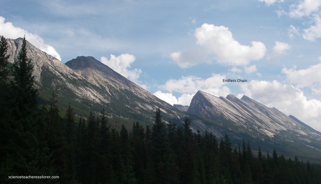
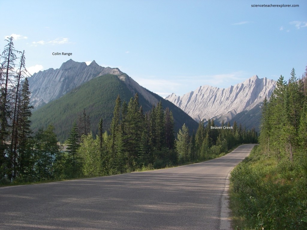
Pictured above and below, the several peaks with glaciers and snow patches are in the Churchill Range with Mushroom Peak and its spurs prominent to the south. At this location, the Icefields Parkway is close to the axial part of a syncline or downfold; that is, close to the very bottom of the trough of rocks that dip in from each side toward the center. On the the eastern side, great dip slopes of pink quartzites from the flanks of the Endless Chain Ridge. On the other side of the valley and on the side of the trough or syncline, the crests of the mountains are in rocks that clearly dip toward Banff-Jasper highway.
A branch road about a kilometer long leads from the main Banff-Jasper highway to Sunwapta Falls and canyon. From the road junction the view west shows the bedding of the rocks to be nearly flat. Straight along the road but a little to the to the right, the beds dip conspicuously toward the valley bottom. Pictured below, southeastward up the Sunwapta River valley, great dip slopes of lower Cambrian quartzites in the Endless Chain Ridge form the eastern side of the syncline or trough-like fold whose axis runs along the valley of the river and highway.
At the falls itself we find a place where the Sunwapta River changes course sharply from northwest to southwest and then plunges over the falls into a deep canyon. Pictured below, it seems likely that the river has been pushed out of a pre-glacial valley by glacial damming. The falls resulted when the river flowed over the edge of ready-made cliffs, and since then it has gradually worked its way back by erosion to form the canyon.
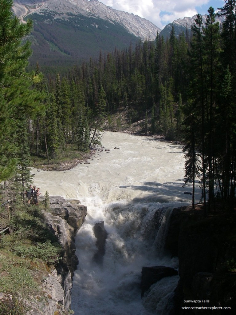
Pictured above, the rocks at the falls and in the upper part of the canyon dip very gently, for this region is very close to the bottom of the trough or synclinal fold in the area. [After about 2 km of turbulent flow and other falls, the Sunwapta River reaches the valley flat of the Athabasca River, which comes from the south and joins it a little farther on.
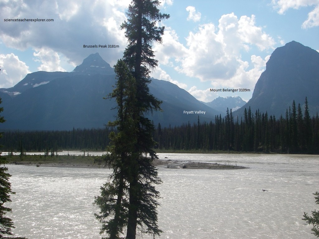
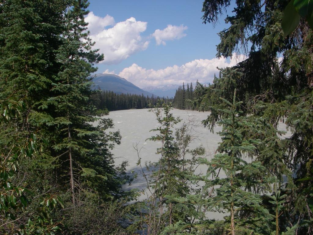
Pictured above, one can see for many kilometers up and down the wooded Athabasca River valley with the full spread of the high mountains and Fryatt Valley on the other side. Pictured immediately below, the Athabasca River flows swiftly but not violently on its way, forming islands in some places, cutting into banks and leaving deposits on others. The mountains opposite are cut into a great thickness of Pre-Cambrian and Cambrian quartzite that grades upward into limestone. To the left of Fryatt Valley, lies Mount Christie (hidden behind the tree), with small glaciers on its front. Behind Mount Christie on the same ridge lies the steep-walled Brussels Peak, looking rather like the funnel of a large ship.
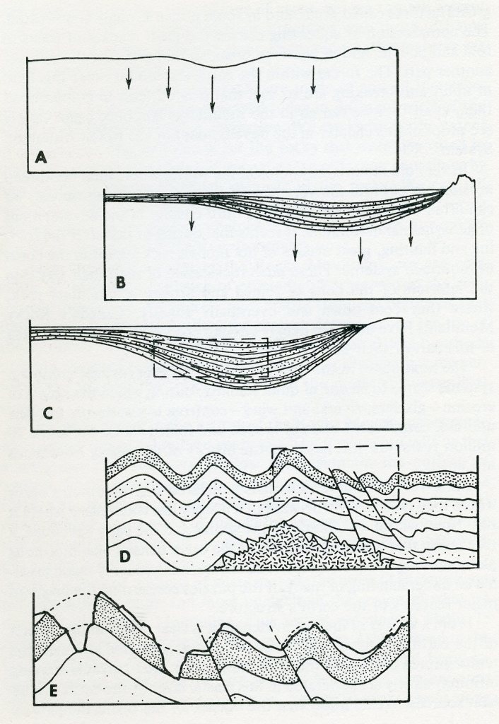
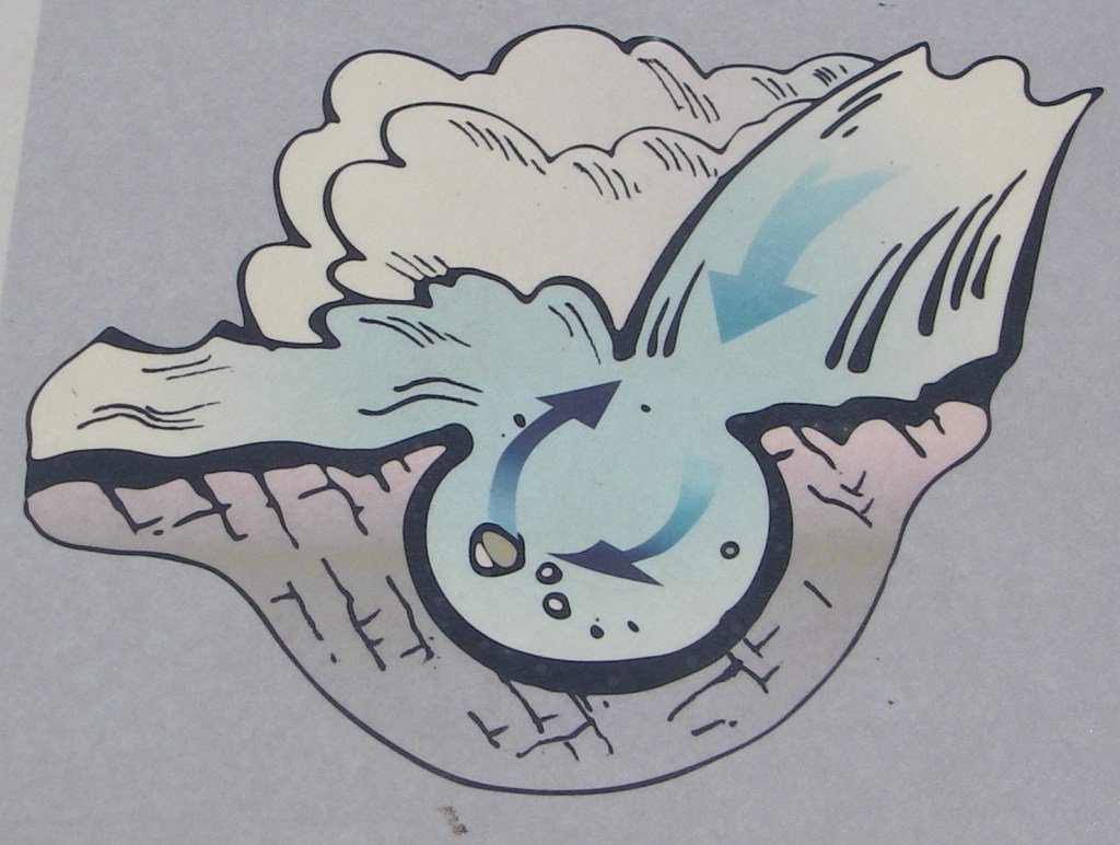
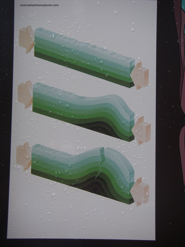
The spectacular peaks and valleys of the Canadian Rocky Mountains as we know them today are made of rocks which record a story that began more than 600 million years ago. At that time part of western North America began to warp downward to form an elongated trough as in “A” in the above image. Rivers poured sand, silt, and gravel into the lowland area. Down-warping continued until the trough was filled with a shallow sea, into which poured a steady flow of sedimentary materials, as in “B” in the above image. Down-sinking continues, but it seems to have been at a rate that corresponded closely to the rate of filling, so that sedimentation was always into shallow marine waters. The mass of sedimentary materials slowly changed to sedimentary rock as the load on top increased until it had a form like that in “C” of the above image. The main period of mountain-building was between 80-60 million years ago during the Laramide Orogeny. The trough area was then severely compressed so that the rocks in it were folded and broken. At about this time in the history of such mountains great masses of molten materials commonly appear in the cores of the folded and broken, eventually solidifying into granite. “D” is a depiction of this, in the image above. Uplift accompanied the folding and faulting, and as soon as the rocks emerged from the sea they were subjected to erosion. Rivers and glaciers carved the valley and formed the peaks as shown in “E” in the image above.
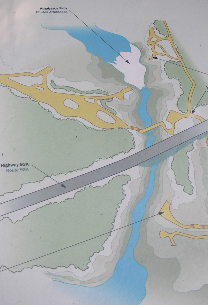
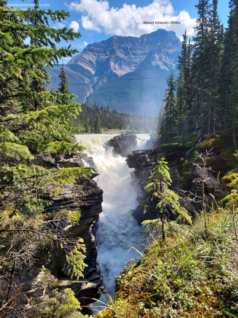
Imaged above and pictured below, at the foot of Mount Kerkeslin the Athabasca River plunges over a cliff of Precambrian quartzites into a narrow canyon of its own cutting. High above in the background looms Mount Kerkeslin with its gently down-bowed sedimentary rocks. Wooded slopes reach partly up its flanks, giving way there to bare scree or talus. Above this the Precambrian and Cambrian quartzites lie layer upon layer to the very peak. Notice in the picture below, two bright red layers in the lower part of the cliff just above the tree line on the left or northwest face of Mount Kerkeslin. These contain abundant iron oxide or hematite which gives them their color. Look at the pattern of gullies and ridges in the southwest face of Kerkeslin with occasional slide areas extending down into the woods. Note that Mount Kerkeslin thrusts its synclinal mass of rocks some 9,800 meters above sea level and gives way to the east the evenly dipping, rusty rocks of Mount Hardisty.
Mountains are very commonly cut by erosion into masses of rocks that have been folded into great arches and troughs. Erosion over long periods may cut away all the surrounding rocks to leave a mountain with a trough or bowl structure within it. This probably comes about because the folded rock in the center of the trough, which is called a ‘syncline’ are move resistant to erosion than those in the surrounding parts, which tend to split and break during folding. Mount Kerkeslin is an excellent example of a synclinal mountain.
Imaged below, during the last glaciation, the Athabasca Valley Glacier inched over this rock, shearing off chunks to a create a cliff. A softer rock would have been ground down to a smooth incline, but Jasper’s hardest rock, Gog quartzite, broke off in large chunks.
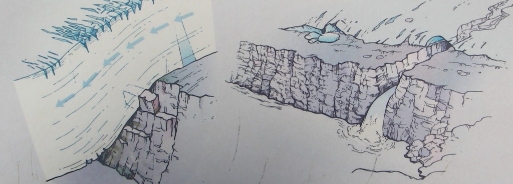
Imaged above and pictured below, a stream flowing underneath the glacier started forming the canyon. As the glacier receded, the Athabasca River took over and continues whittling away a few millimeters of rock each year.
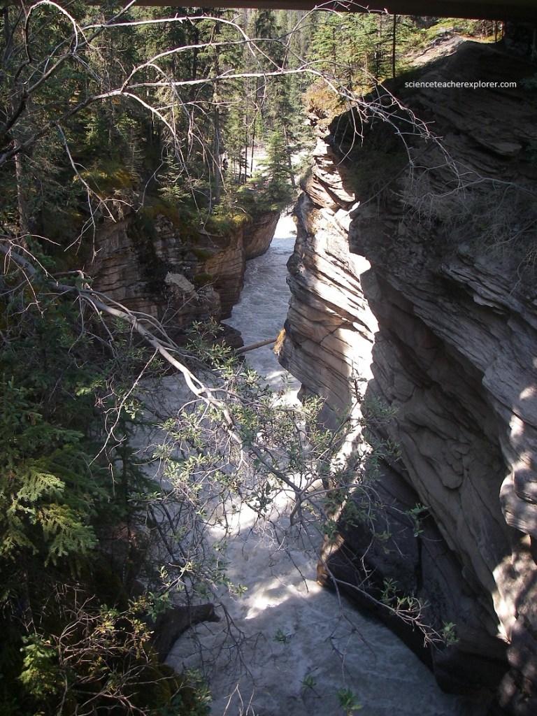
Pictured below, near the falls and in the woods along the left bank, (as you face down the stream & canyon), abundant channels and old potholes show that the river once flowed over a brad section of the rocky cliffs.
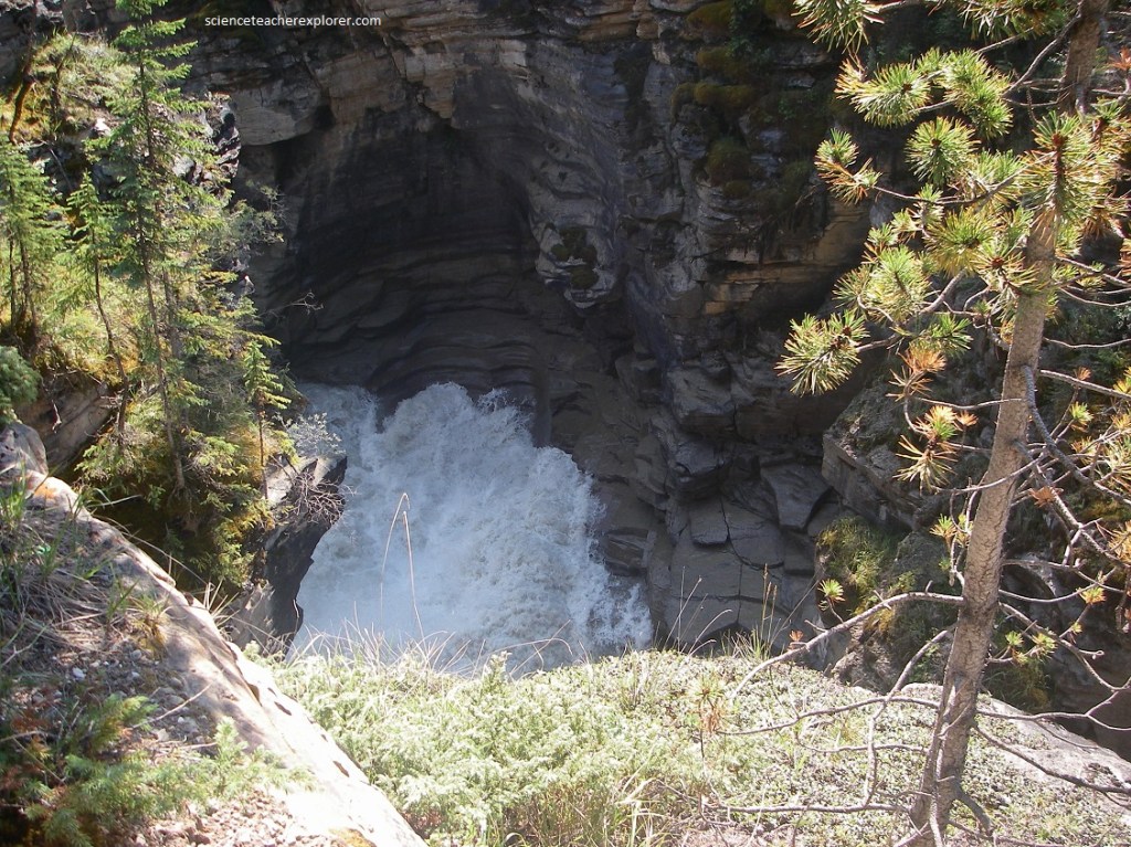
Imaged below, recipe for a pothole. First, trap sand or gravel in a depression. Add water that whirls it around and around, scouring the bedrock. Leave until the depression deepens and becomes rounder. The pothole is done when the water changes its course. Trapped and spinning water’s direction, particles of sand, silt and gravel carve like a diamond drill. The river took thousands of years to drill the potholes now suspended on the canyon walls.
Pictured below, the present falls will slowly cut more deeply into the central section of the river bed and abandon the flatter side areas which were more broadly flooded as little as fifteen years ago.
Pictured above, flowing water relentlessly battled the bedrock, carving this channel. Later, water found a break elsewhere in the rock’s defenses, (this channel was forsaken). After centuries of battle, the waters surrendered and abandoned this channel.
Pictured above, near Athabasca Falls, Becky and I took a detour on the old Banff-Jasper route 93A. This route gave us access to the Mount Edith Cavell road.
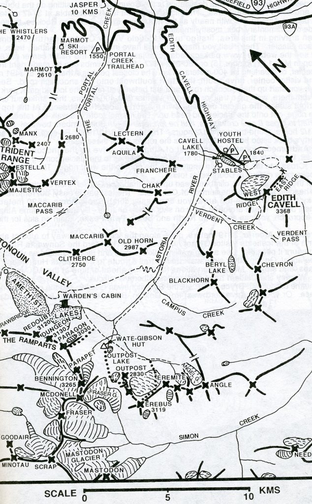
Pictured above, at and across from this viewpoint, a great plug of glacial deposits has been cut through by the Astoria River. The boulders in the deposits are slightly rounded and a faint banding can be seen in the cliff opposite, suggesting that these are water-worn deposits, perhaps laid down in meltwaters in front of or beside a tongue of ice that once occupied the Astoria River valley. When dry, this mixture of boulders, sand, and clay seems fairly strong, but when wet it is probably soft and almost fluid so that land slips are frequent, as shown in the bank on the other side of the river. The material is eroded rapidly and irregularly so that some pillars are left, as in the cliff immediately below the viewpoint.
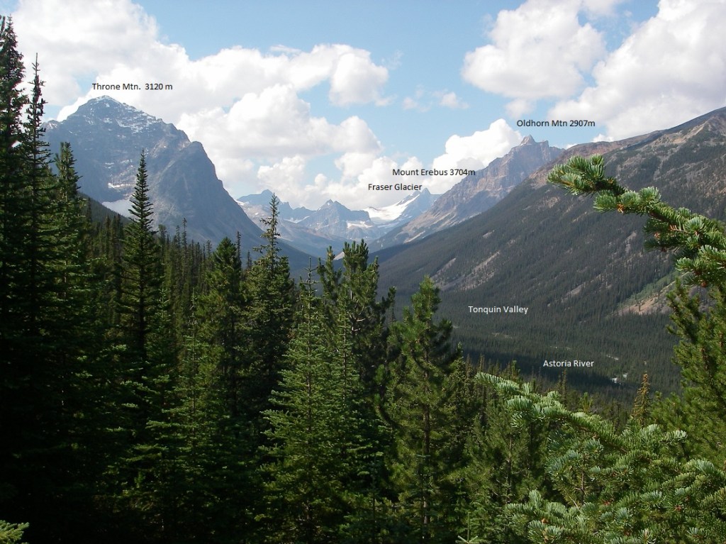
Pictured above, the gently curved Astoria River valley (Tonquin Valley) stretches off to the snow-covered mountains on the Continental Divide. On the distant skyline a part of Fraser Glacier gleams white, with Mount Erebus on its right and the mighty Ramparts around the corner just out of sight. On the right or the north side of the Tonquin Valley, Oldhorn Mountain shows layers of left or inward dipping quartzite. Immediately opposite the viewpoint is Franchere Peak with reddish and brownish weathering quartzite with a southerly dip, (pictured below). On the left side of Tonquin Valley, beyond the rusty right-hand mass of Edith Cavell, is Throne Mountain, so aptly called because of the great amphitheater or thronelike basin carved in its near face. This is a cirque that has been made by ancient glaciers.
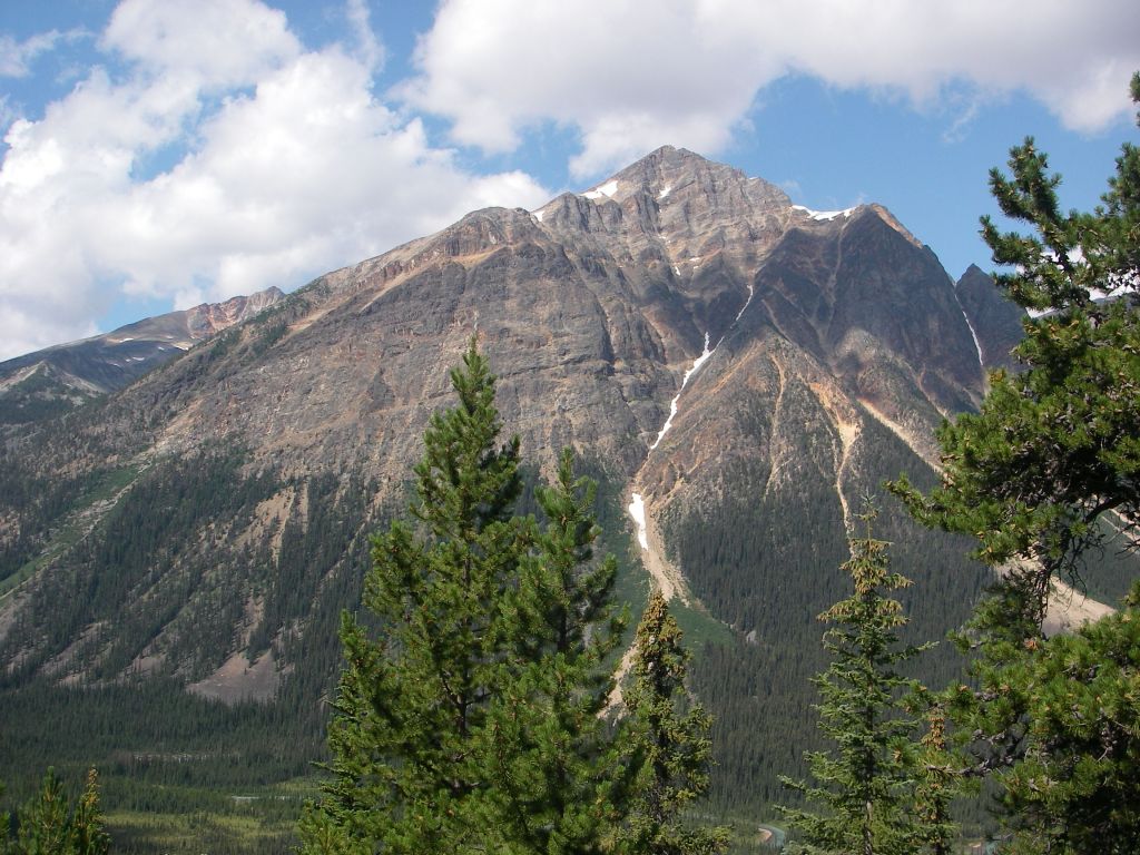
Pictured below, Mount Edith Cavell, at 3,365 meters, is cut into Pre-Cambrian and Lower Cambrian rock beds that dip gently southwest. A great curving rock wall has been cut into the northeastern face of the mountain, and it is this side that provides the very beautiful view from the end of the road and from Jasper itself. The mountain itself forms part of a long line of mountain extending for many kilometers along the southwest side of the Athabasca River Valley. Structurally, Mount Edith Cavell is also continuous with the mountains along the valley, for it lies on the southwest side of an “anticlinal” structure extending for many kilometers to the southeast. In this region of folded rocks, mountains are underlain by great up-bowed or arched masses of rock. Such upfolds are ‘anticlines’ and the mountains are called ‘anticlinal mountains’. Stretching of the rocks on the upper layers results in numerous fractures which in turn make the rocks very susceptible to erosion.
It should be mentioned that the rocks of Mount Edith Cavell are of Lower Cambrian and Pre-Cambrian age and are almost entirely made of quartzite which comes from the recrystallization of sandstone.
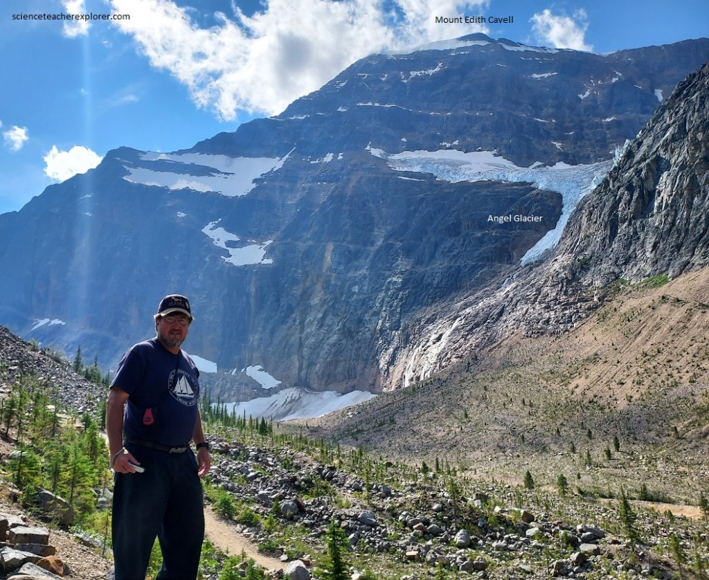
Pictured above, Angel Glacier lies in a saddle area on the northeast slope and sends a tongue of ice over the cliff-side. In very recent times it reached continuously to the valley bottom but has been steadily shrinking so that it now hangs suspended on the rocky wall as a sort of immobilized icefall. Below it are large cones of debris mixed with ice, and a flush of meltwater issues from the bottom of the ice tongue. A triangular area of rock more lightly stained than that around it suggests the former shape of Angle Glacier. “Lateral moraines”, (piles of rock waste left along the sides of glaciers), occur along both sides of the valley above the end of the road and parking lot. Some of these are very steep sided towards the ice, and show clearly on their backs that they were pushed up against the banks there.
After staying the night at the Jasper village, Becky and I explored the nearby Maligne Canyon drainage system. This drainage valley is about 80 km wide and empties into the Athabasca River via the Maligne River in a little more the 5 km below the village of Jasper, at an elevation of about 1,006 meters above sea level. It’s principal reservoir is Maligne Lake, about 40 km above its mouth and 1,674 meters above sea level. The river thus has an average gradient of about 15 m/km, which is very steep. Medicine Lake lies in the course of the river about 16 km above its mouth at an elevation of 1,448 meters above sea level.
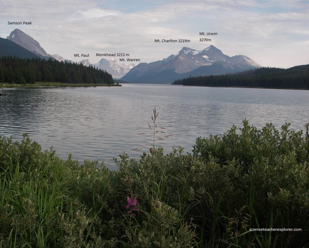
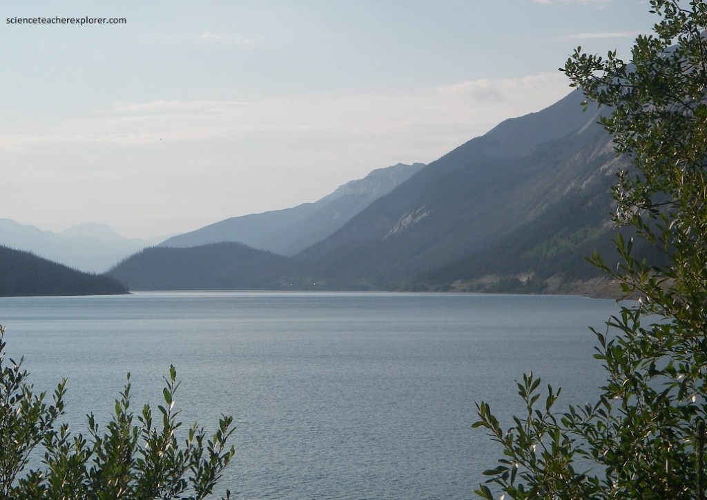
Pictured above, Maligne Lake itself is the result of the deepening of the upper end of the valley by the glaciers and the damming of the valley by sand, gravel, and rock rubble in the vicinity of its present northwest end. Depressions call “kettles” are numerous in the woods beside the road in the last kilometer or so before the boathouses at the northwest end of Maligne Lake. The view to the southeast down Maligne Lake is very beautiful indeed. A group of great peaks far down the lake to the right includes Mount Unwin and Mount Charlton, both more the 3,200 meters above sea level, and others which are only partly visible behind them. This block of mountains belongs to the Front Ranges. On the left or northeast side of the lake the peaks include Leah Peak and Samson Peak. The great boundary fault between the Front Ranges to the east and the Main Range to the west, in this neighbourhood passes along the slope of the hills 3-4 km inland from the southwestern shored of Maligne Lake.
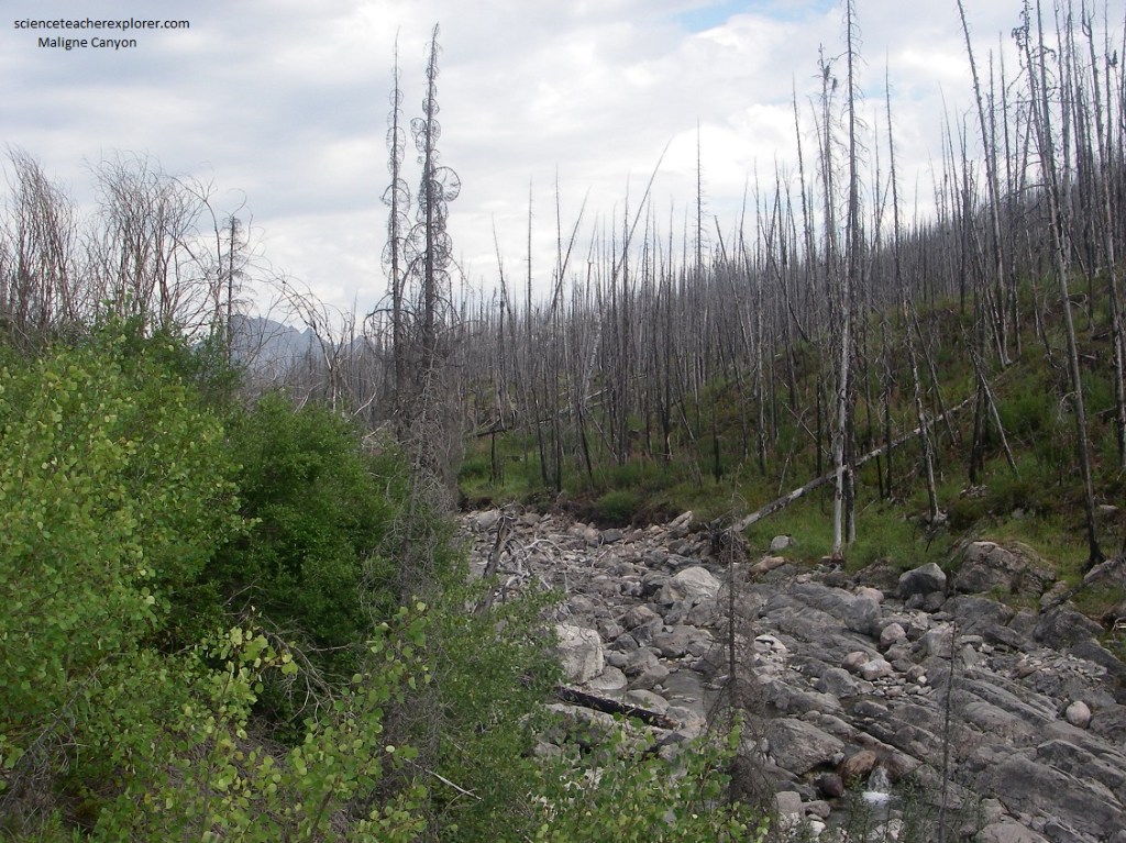
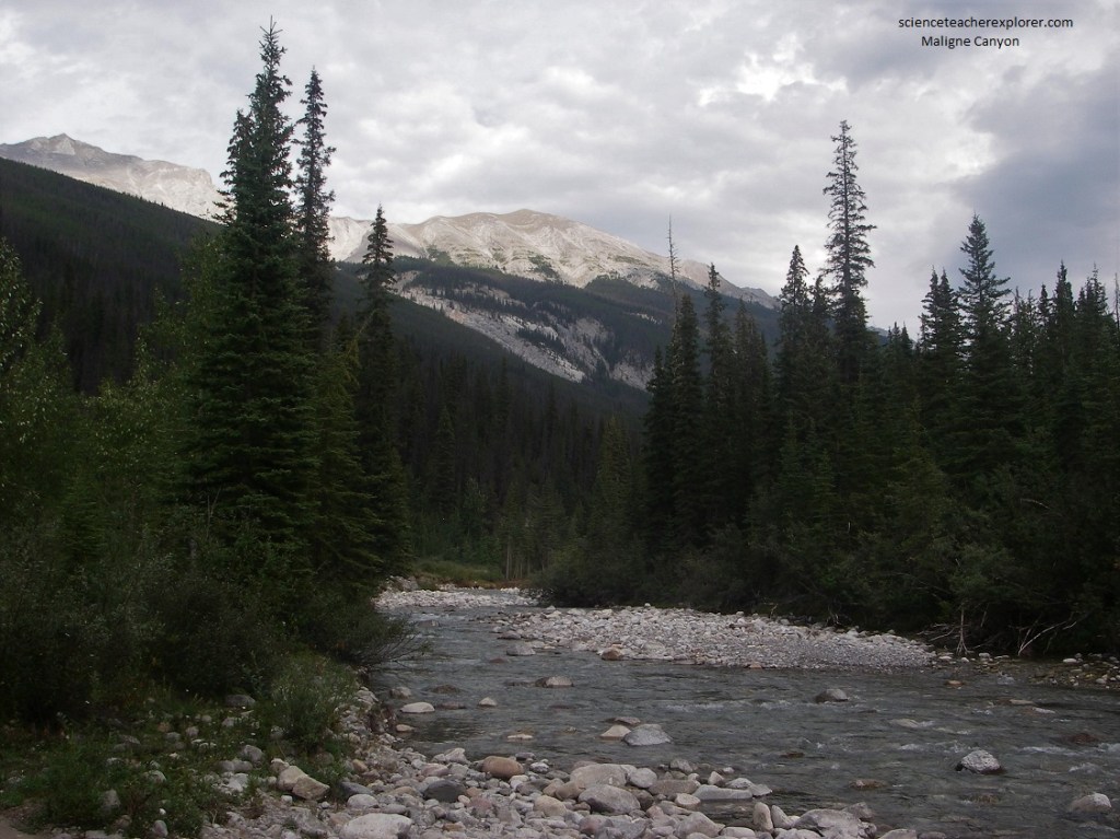
The road between the southeast end of Medicine Lake and northwest end of Maligne Lake follows a valley that was heavily glaciated in the recent geological past. As the ice melted and retreated from this valley, large deposits of glacial debris were dumped all along it. The Miligne River, which drops more than 210 meters in 11 km, flows swiftly along in a course choked with gravel and great boulder left by the ice long ago. The upper end of the Maligne River is a normal fast-flowing stream that derives its water from melting snows on the mountains all around. When the water of the Maligne River enters Medicine Lake, however, its behavior is no longer ordinary, for some of it is held there in storage while the bulk of it disappears into the underground drainage system.
Pictured above, the view northward from the southeastern end of Medicine Lake shows two ranges of mountains cut in steeply tilted limestones and shales. The ridge closest to the northeast shore shows great dip slopes of grey limestones with partly wooded scree and talus heaps. To the right, a sharply marked valley leads into the Beaver Lake area. A second series of spectacular sawtooth ridges is visible from the end of the lake, with the massive grey limestones holding up the main ridge and overlying brownish shales and minor limestones in the sawtooth spurs. Here is where you see the great gush of the Maligne River pouring into Medicine Lake, with no equivalent outflow on the other end.
Pictured above and below, the mound toward the far end of Medicine Lake is the remnant of a massive rock slide. There, several hundred years ago, a large section of steeply dipping bedrock crashed down into the valley from the mountain to the east.
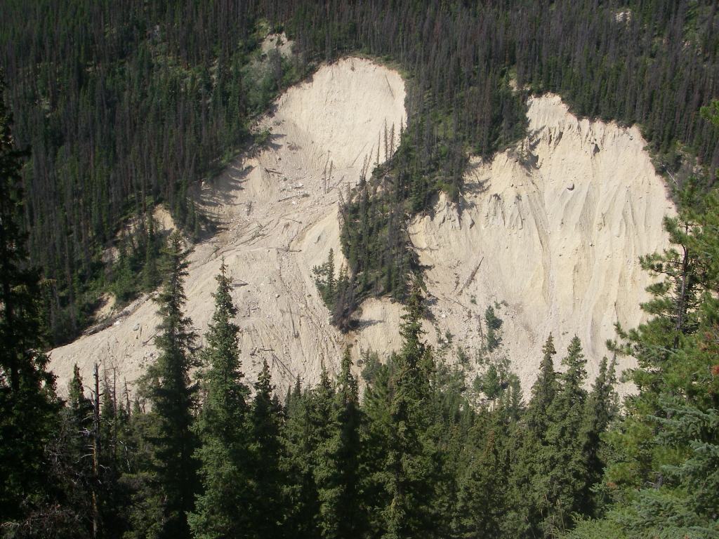
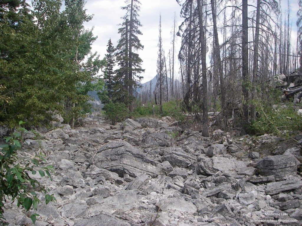
Imaged above, such events are not uncommon here, where glacial erosion of the lower slopes has over-steepened the valley walls. From time to time, small slides tumble down onto the road, reminders that sculpting of the landscape continues.
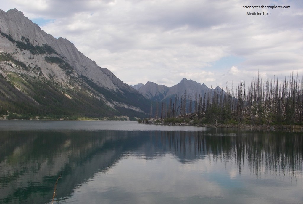
Pictured below, the outlet at the northern end of Medicine Lake seems to disappear; and during much of the year the upper end of the Maligne River, just below Medicine Lake, consists of a dry streambed between scattered pools. At the other end, (southern end), of Medicine Lake you willsee a rushing river entering the lake. Where does the water go? Some of it is used to fill up the basin of Medicine Lake, which becomes almost empty during the late fall and winter. Some of it must go underground.
Pictured above and below, as we explore northern outlet end of Medicine Lake, we noticed that the Maligne River to our right disppears almost completely. During most of the year, a walk around the outlet end of Medicine Lake will show that there is no outlet al all. For a brief period, in the middle and late summer, Medicine Lake spill out over the rocky channel-way so that there is a thread of water all the way down. At other times, however,, it drains by underground channels. Indeed, in the late fall the lake bottom is mostly bare with the Maligne River entering its upper end, wandering over the flats and then disappearing down holes. The local park rangers say that underground falls can clearly be heard and that the water can be seen going underground in several places. The inlets appear to be principally along the northeast side, with several near the cove leading to the Beaver Lake Valley at the southeast corner of Medicine Lake. Traveling over the shriveled remains of the lake is dangerous in winter because of the distributaries and flats and the occasional deep holes.
The whole northeast side of Medicine Lake is dominated by the great dip slopes of grey limestones with talus and rubble heaps at their feet. Boulders, which have come from the erosion of the cliffs above, line the northeast shore of Medicine Lake.
Limestone is easily dissolved in rain water. In limestone areas that have considerable relief it is common for surface water to disappear into the ground along cracks and fissures, to form underground streams. These reappear as springs and seeps somewhere lower down. Once underground, the water works it way downward into the rocks and dissolves the limestone, and thus enlarges the openings so that more and more of the surface water joins the underground system.
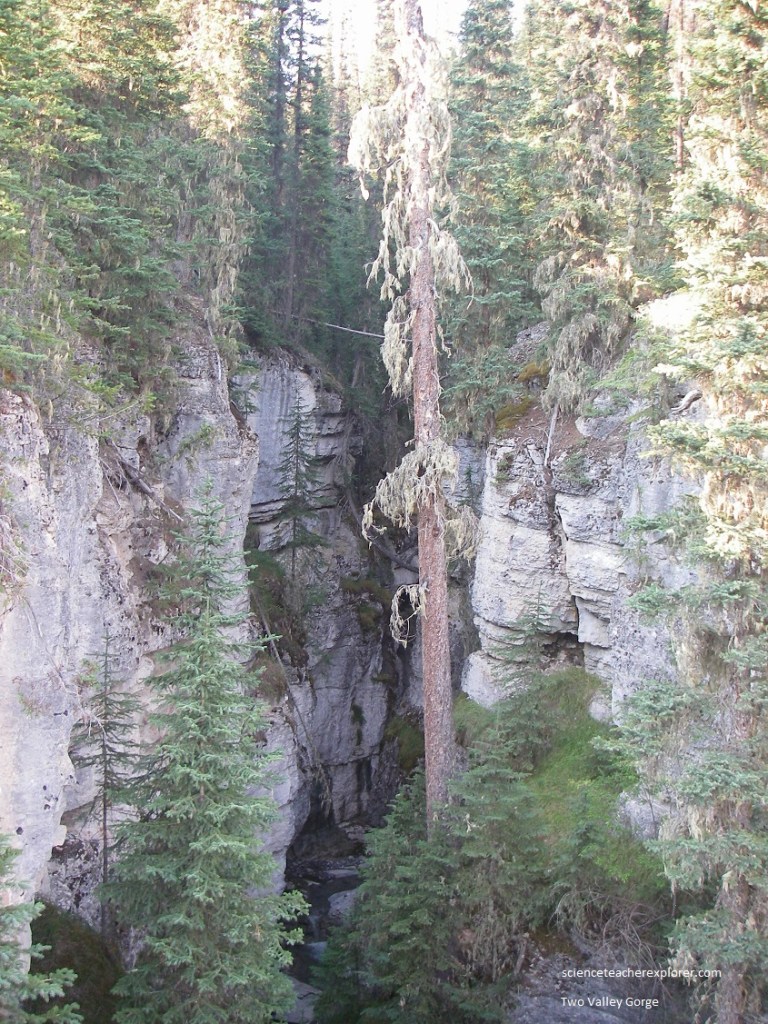
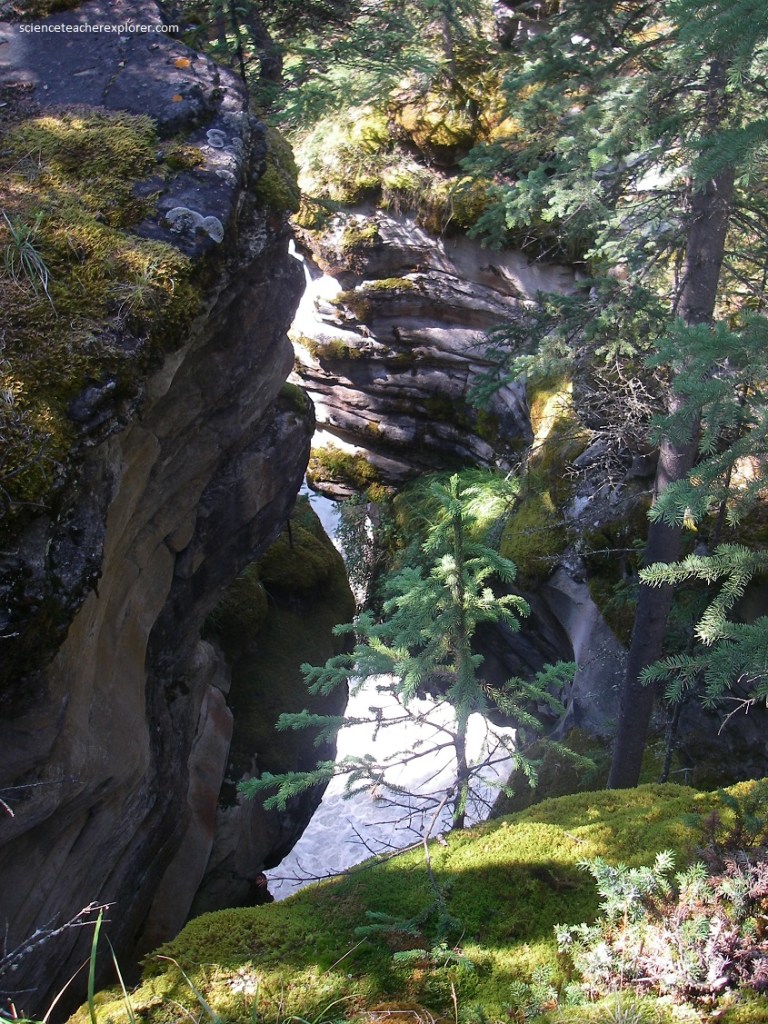
Pictured above, the road along the valley of the Maligne River below Medicine Lake is cut principally in the limestones of the Palliser Formation. This is natural because the valley would be expected to follow the general strike of the rock structures in the area. Pictured above from the bridge over the Two Valley Creek, affords a view of another of the many steep-walled gorges cut into the limestones of these mountains. You can see from its shape that the gorge has been cut by a combination of abrasion or wearing away by mechanical action, and solution, which produces rounded surfaces. Remnants of potholes are visible in some places. The bottom of the canyon is perpetually gloomy, with the constant rumbling of falling water. To the left, forests and smaller vegetation cling to the grey dip slopes of the limestone beds.
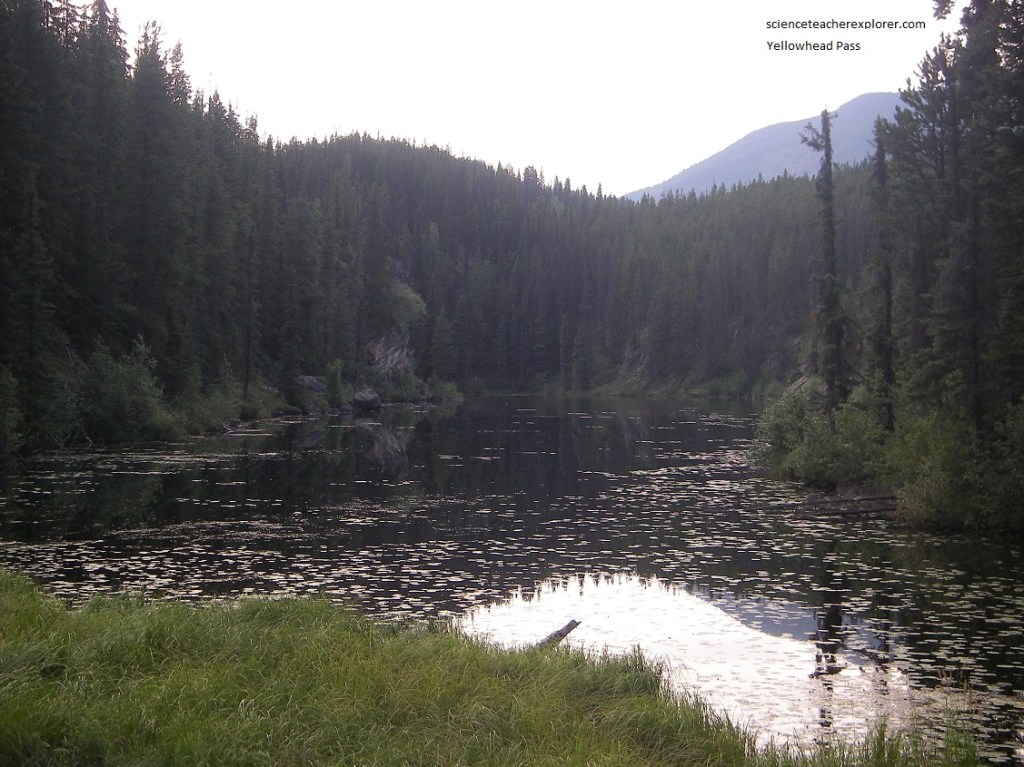
After exploring Maligne Canyon, Becky and I took a brief detour from the Jasper Village to Yellowhead Pass. One of the lowest places on the Continental Divide is at Yellowhead Pass, only 1,131 m above sea level. Water flows east ward from this divide through Miette River to join the Athabasca River near Jasper and finally empty into the Arctic Ocean. Water flows westward into a tributary of the Fraser River and ends ultimately in the Pacific Ocean at Vancouver. The divide here is part of the Alberta-British Columbia boundary and is the western boundary of Jasper National Park.
Yellowhead Pass was name after Pierre Bostonais, an Iroquois-Metis guide and fur trader who spent much time in the area and led an expedition through the pass in 1825. Bostonais was known by the nickname ‘Tete Jaune’ or ‘Yellow Head’, due to his unusual fair hair. The first place to bear his nickname, was Tete Jaune Cache, the location where he cached the furs he trapped. His legacy lives on by having a village, a lake, a mountain and a highway named for him. For thousands of years and long before it was named Yellowhead, this low pass was used by indigenous peoples. For Aboriginal people this corridor was an important travel and trade link, providing access to hunting and gathering of food and medicinal plants on both sides of the divide.
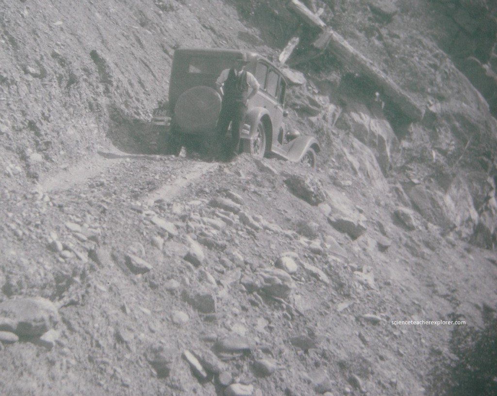
In the 1920s, portions of the abandoned rail line through Yellowhead Pass became a rough trail for adventurous automobile travellers. Formal road construction did not begin until the 1940s. During the Second World War, internees did not begin until the 1940s. During the Second World War, internees from the Japanese-Canadian internment and conscientious objectors camps laboured on road construction in the Yellowhead Pass and occupied camps in the area. It was not until the late 1960s that the paved Yellowhead Highway was completed.
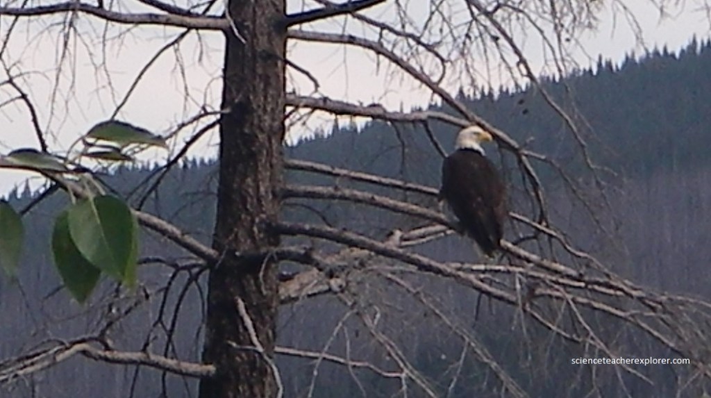
The American, or bald eagle, became the national emblem of the United States by a 1782 Congressional act. The eagle is a solitary bird and chooses only one mate for its whole life-time, (pictured above and below).
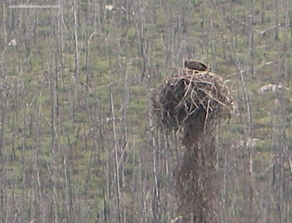
Pictured above, it builds a single nest high up in a great tall tree. Each year the eagle adds more material to repair this big nest. After a few years, the nest may weigh as much as 2,000 pounds. Sometimes, a tree dies and the nest comes crashing to the ground. The eagle must then construct a new nest in another tree.
