Banff N.P., Alberta 2022
In August of 2022, Becky (my wife) and I were exploring the Canadian Rockies. Some of the most beautiful mountain scenery in the world is to by found in the Rockies of western Alberta and adjacent eastern British Columbia. An area of 6,641 square kilometers in this region has been set aside as Banff National Park for the enjoyment of present explorers like ourselves. The western boundary of Banff National Park is the Great Divide and the rivers which rise in its vicinity flow into the Arctic, Atlantic and Pacific oceans. Pictured below, the park may be entered from the west through the Kootenay and Yoho National Parks in British Columbia, and from the north through Jasper National Park, in Alberta. The entrance from the east is probably the most spectacular because the mass of the Rockies is in view continuously for the beautiful approach of more than 100 km from Calgary until the park gate, and that is the way Becky and I chose to start exploring.
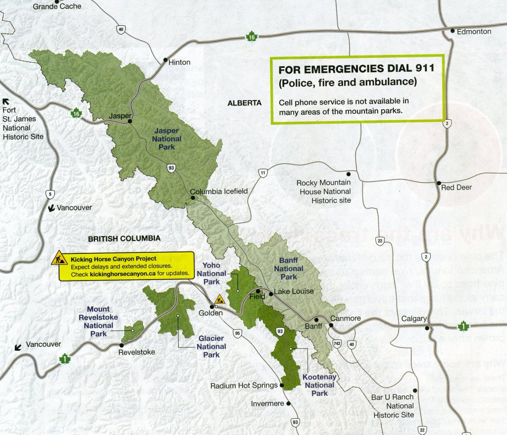
Sharp jagged peaks and rounded mountains, slow-moving glaciers and dazzling white snowfields, rushing mountain streams and gently rivers, narrow canyons and open wooded valleys, and alpine meadows and dense forests, (all of these describe Banff National Park). Banff National Park encloses an area on the eastern slope of the Rocky Mountains from the Continental Divide, including the drainage area of the Bow River above the village of Banff, the headwaters of some easterly flowing streams to the northeast and southwest, and the drainage area of the North Saskatchewan River and its tributaries above its junction with Owen Creek, about 5 km downstream from where the Banff-Jasper highway crosses the river.
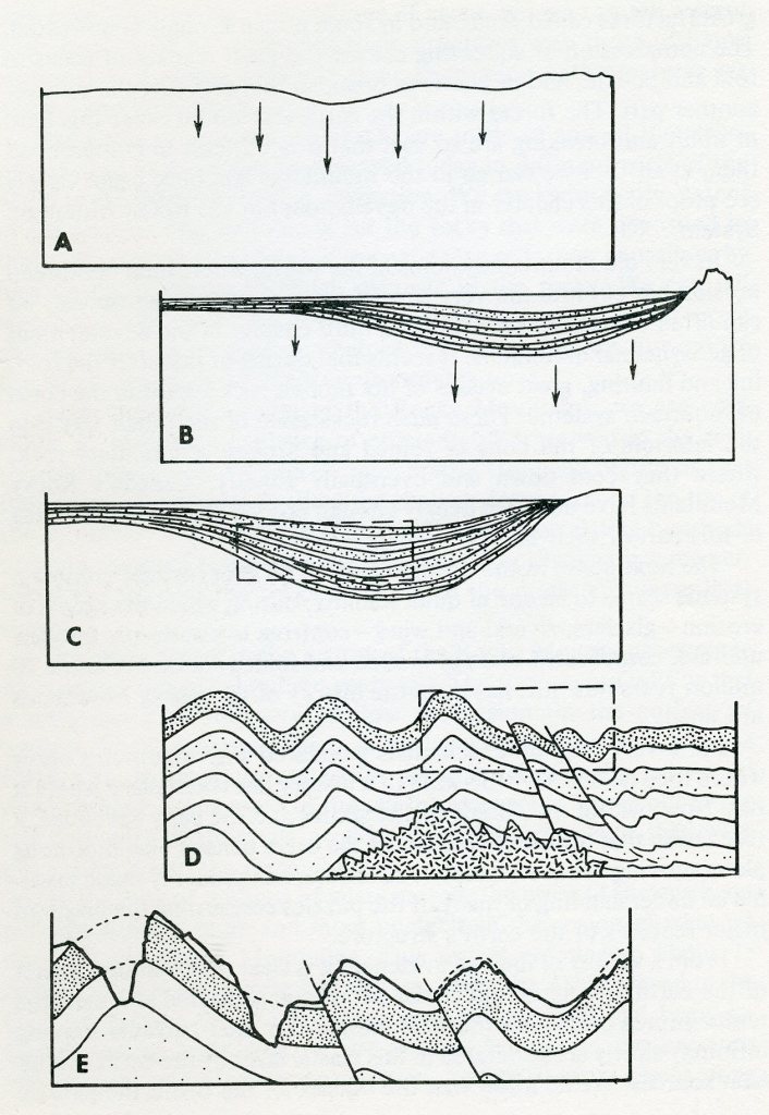
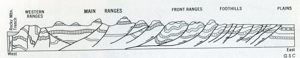
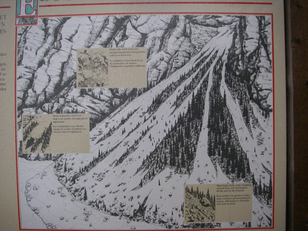
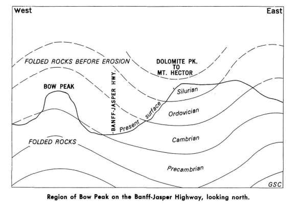
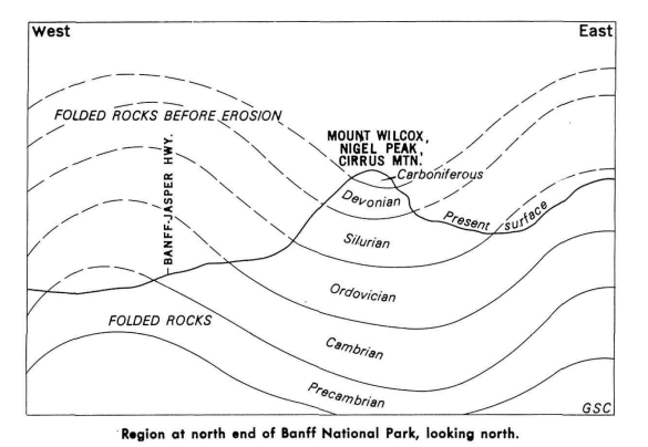
The spectacular peaks and valleys of the Canadian Rocky Mountains as we know them today are made of rocks which record a story that began more than 600 million years ago. At that time part of western North America began to warp downward to form an elongated trough as in “A” in the above image. Rivers poured sand, silt, and gravel into the lowland area. Down-warping continued until the trough was filled with a shallow sea, into which poured a steady flow of sedimentary materials, as in “B” in the above image. Down-sinking continues, but it seems to have been at a rate that corresponded closely to the rate of filling, so that sedimentation was always into shallow marine waters. The mass of sedimentary materials slowly changed to sedimentary rock as the load on top increased until it had a form like that in “C” of the above image. The main period of mountain-building was between 80-60 million years ago during the Laramide Orogeny. The trough area was then severely compressed so that the rocks in it were folded and broken. At about this time in the history of such mountains great masses of molten materials commonly appear in the cores of the folded and broken, eventually solidifying into granite. “D” is a depiction of this, in the image above. Uplift accompanied the folding and faulting, and as soon as the rocks emerged from the sea they were subjected to erosion. Rivers and glaciers carved the valley and formed the peaks as shown in “E” in the image below.
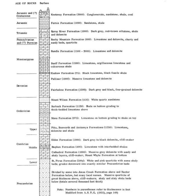
Imaged below, the rock layers that form the mountains were originally laid down one on top of the other. In the Banff National Park, they include different kinds of rock and different kinds of fossilized animal and plant remains. Scientists have determined the stratigraphy of the time-line and rock types as they have occurred in Banff National Park.
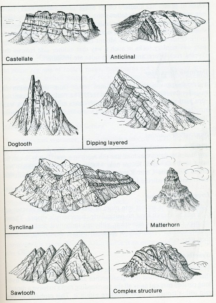
The surface of the land presents an extremely rough and varied scenic scenes. Mountains of many different shapes and sizes stand high above deeply incised valleys. The mountains are sculptured from great up-arched or masses of rock which formed from sediments laid down in the seas that covered the area some 500 million years ago, in the Cambrian Period. In some places the rocks are lying flat, even in the highest mountains; in others they are standing on edge. Deep etching of this irregular mass has resulted in a great array of mountain types, (from those with sharp jagged peaks to those resembling castles). The sides of the mountains, extending as they do through thousands of meters vertically, expose many varieties of sedimentary rocks (imaged below).
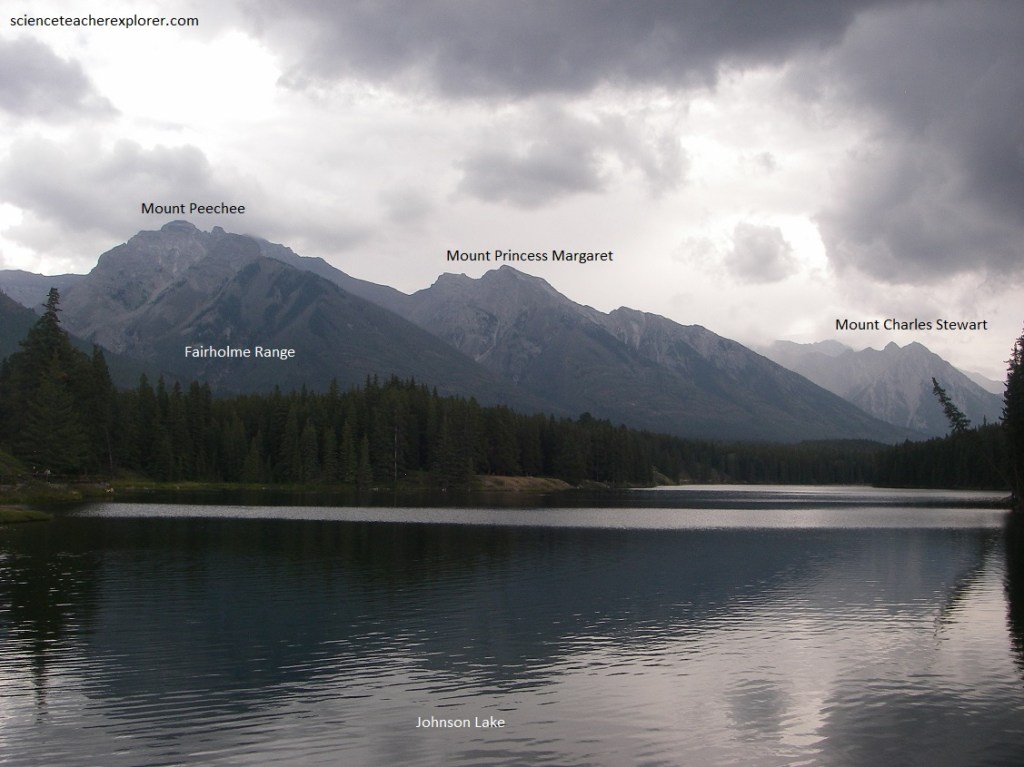
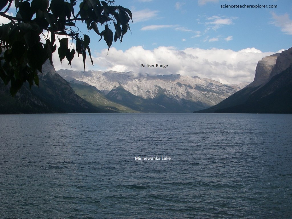
Coming into Banff National Park from the east we saw the skyline of the high Rockies beyond the foothills with tall sharp peaks, more gently rounded ones, and others with one side steep and the opposite one more gently sloping. Pictured below, from the Trans-Canadian Highway #1 we turned at the junction of Lake Minnewanka road. From this road junction the view southward shows a magnificent procession of jagged ridges along the crest of the Rundle Range on the west side of the Bow Valley. Here and there are glimpses of the Fairholme Range on the eastern side of the valley. Pictured below, Mount Charles Stewart lies to the right of the Johnson Lake Valley and Mount Princess Margaret to the left. The rocks in both of these peaks dip westward toward the Bow River valley, along which the highway #1 is located.
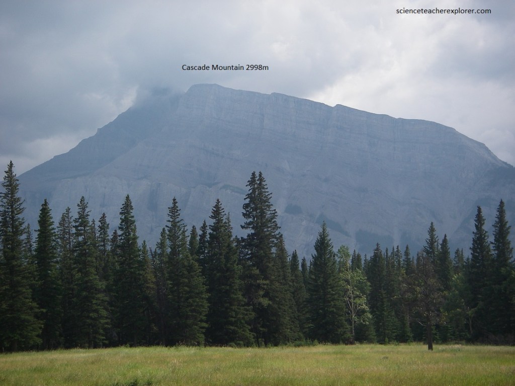
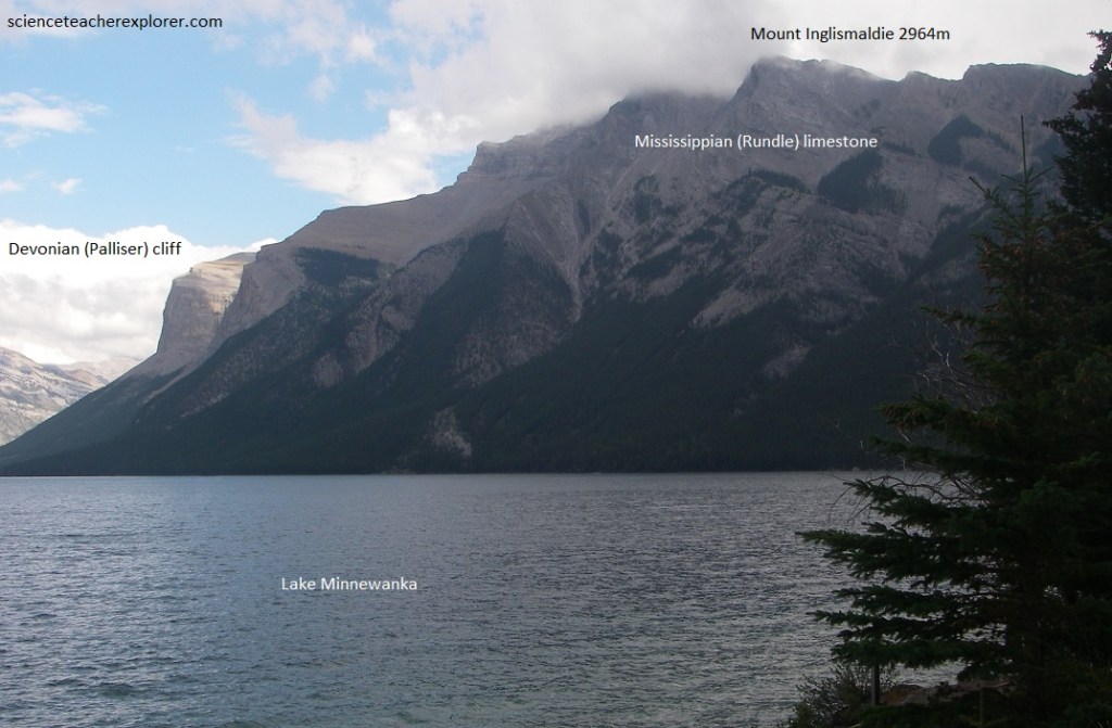
The road from Banff to Lake Minnewanka runs under Cascade Mountain along a deep valley, once the channel of Cascade River, and comes to a stop at the western end of beautiful Lake Minnewanka. Northwestward, straight up from the road, the great mass of Cascade Mountain looms across the view with three deep gashes in its lower limestone cliffs. The left one has a thin white ribbon of falling water and it is from this that the mountain gets its name. The main grey cliff in the bottom is the Palliser limestone of Devonian age. Above it, slacking off into more gentle, rounded, brownish slopes is the Banff shale formation of Mississippian age. The top of the mountain is in the grey, cliff-forming Rundle limestone, also of Mississippian age.
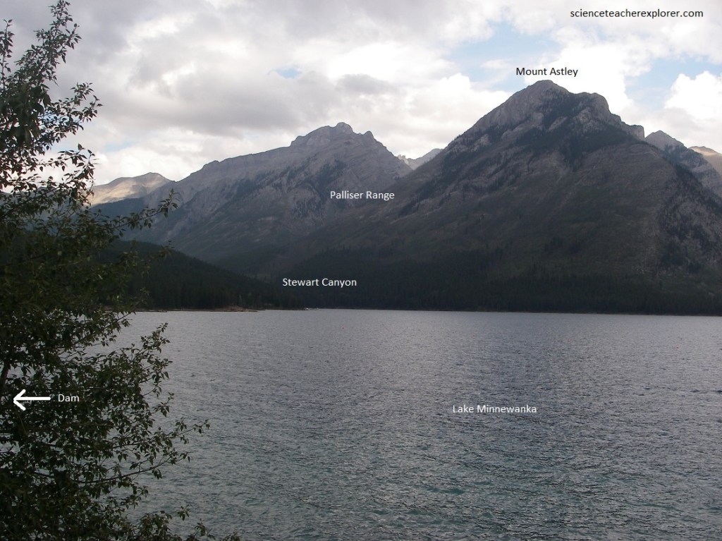
Pictured below, Lake Minnewanka cuts abruptly across the mountain range between Mount Astley of the Paliser Range on the north and Mount Inglismaidie on the south. It is believed to have been the pre-glacial outlet of Cascade River which now empties into the lake from the north through Stewart Canyon. This very steep walled Stewart Canyon has been flooded to a depth of several meters by the damming of the outlet of Minnewanka in very recent times, this making a steep-shored, narrow waterway extending back into the country for more than a thousand meters. Looking northward along Stewart Canyon, the rocks are seen to dip quite steeply to the left or west, and the original canyon was cut more or less down the dip of the rocks themselves.
Pictured below, the road runs along the top of the Minnewanka Lake dam that has lifted the level of Lake Minnewanka some 20m, in order to make a reservoir for hydro-electric power generated near the Trans-Canada Highway #1. This has had the effect of beheading the Cascade River, which used to drain Lake Minnewanka down the steep valley just below the road junction and then into the Bow River. The water now flows through a system of canals and lakes just below and to our right as we face Lake Minnewanka, then into flumes and through to the power-house.
Pictured below, the mountains on either side of Minneanka Lake are a great thrust block of Paleozoic rocks. The Devonian (Palliser) cliff can be seen in the distance on Mount Inglismaldie and is overlain by Mississippian brown shales followed upwards by the grey limestones (Rundle) that form the peak. Warm brown rocks of the Rocky Mountain formation (Pennsylvanian and Permian) and the Triassic slope westwards off the top of Mount Inglismaldie and are exposed along the road at the end of the lake, and immediately below the dam.
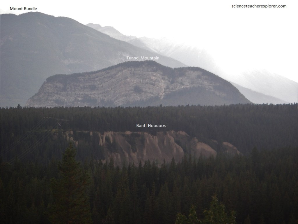
Pictured below, the Banff Hoodoos are formed of cemented glacial till composed of mud, sand and scattered stones left behind by the glacier that once flowed down the Bow River valley. The Bow River has incised its valley into the till since the Ice Age and now flows below. The broad valley has carved by the Bow before the Ice Age, but was widened and deepened by the scouring action of the Bow Valley glacier. The high mountain peaks were not covered but the low mountains, (Tunnel Mountain), were smoothed and rounded by the ice. The floor of the valley is covered with debris composed of pebbles and rock flour ground up and carried by the ice and left when the ice melted. The edge of the Rundle Range stretches off to the south with knobs and irregular peaks sticking out here and there, looking rather like the edge of a notched board. The rocks in Tunnel Mountain are largely made of the Palliser limestone.
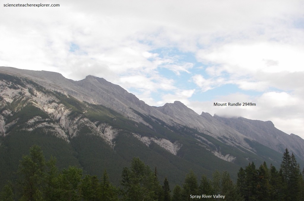
Pictured below, southwest along the Bow River shows very well the sharply marked water gap between the toe of Mount Rundle on the south and Tunnel Mountains, its continuation to the north. The mighty mighty Palliser limestone cliffs near the bottom of Mount Rundle extend off to the east and southeast. Below here the Bow River moves moodily on its way to the distant ocean, carrying its load of suspended and dissolved sedimentary materials. The peculiar little cloud over Mount Rundle’s peak is made by the movement of the air over its slope. As the air, moving generally eastward, travels up the western slope of the mountain, it rises into a region of lower pressure and lower temperature. If the conditions of humidity and temperature are just right, the water vapor in the air will pass the critical point and condense, thus making a cloud.
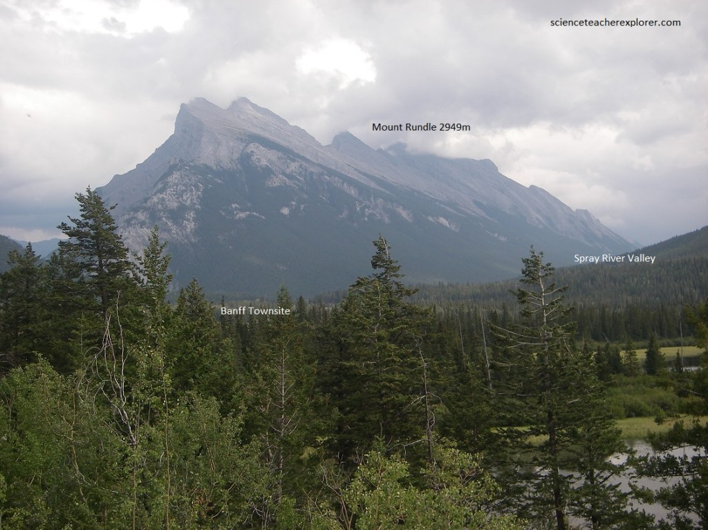
Pictured below, the very crest of Mount Rundle is made of the Rundle limestone and from here it looks like a capping along the top. The slopes seen from here on the northeastern and eastern sides of Mount Rundle are irregular because the rocks dip westward and we are looking at the broken edges of the dipping rock formations. Directly below is the valley of the Spray River on the right, joining that of the Bow on the left. The Spray River rises as it does in a series of streams that pour into the Bow Valley, but cuts across the trend of the mountains. This water used to drain generally north-westward along a fairly large open valley, then suddenly abandoning the valley to flow directly across the trend of the mountain ridges, (Sulphur Mountain in the northwest and the Goat Range in the south-east), to flow in a valley that really belongs to Goat Creek. However, it follows northeastward to where we see it joining the Bow River near the Bow falls.
Pictured below, in earlier times, Bow River flowed northeastward past the present site of Banff to join the ancestor of the Cascade river before turning south-eastward into what is now the lower Bow River valley. Now, because of changes in the level of the land, mostly by the addition of material dumped by the glaciers, the Bow River flows abruptly southeast from the old river valley for a short distance, then turns sharply northeast below the present position of Bow Falls. Here, it cuts through the ridge made by Mount Rundle and Tunnel Mountain in a steep-sided water gap before turning to the southeast to join the Cascade River and the lower Bow Valley.
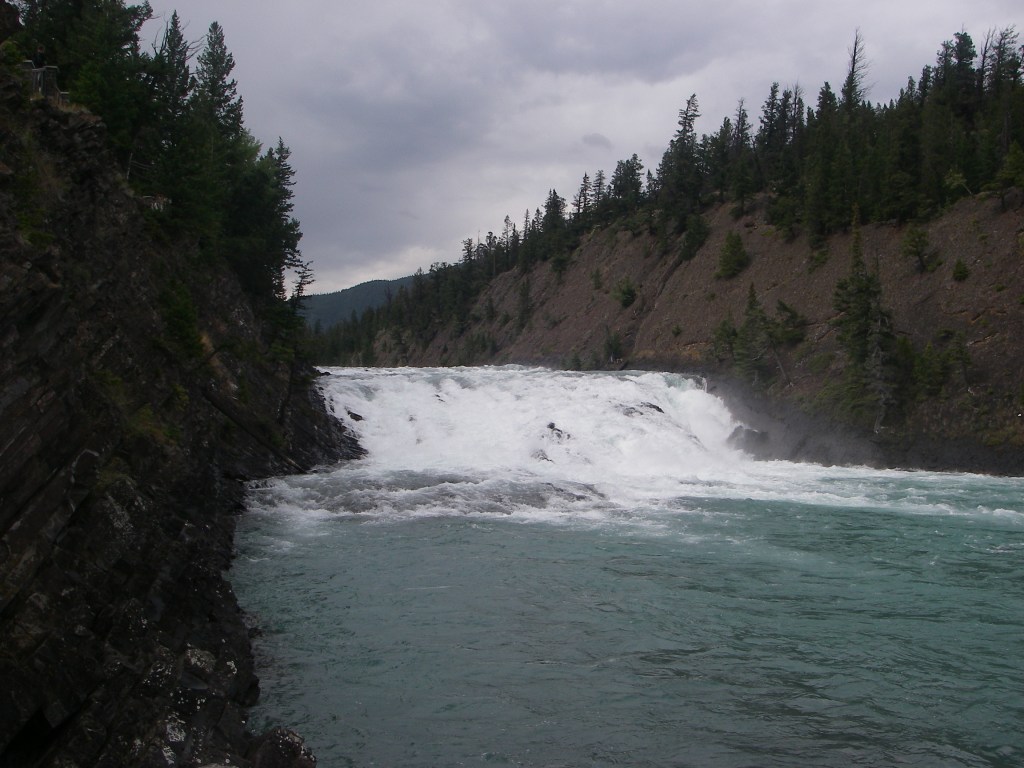
Pictured above, looking upstream, the rocks on the right are of Paleozoic age, (between 240 million and 600 million years old). They form the uppermost part of a sequence that includes both Mount Rundle and Tunnel Mountain. The rocks on the left, on the other hand, are of the more recent Mesozoic era and belong to the Spray River Group, having been formed or laid down in the Triassic period, about 200 million years ago. The Bow River flows along the contact between rock groups of different ages. The fact that it takes this course is no accident, because along such contacts the rocks are often more easily eroded than elsewhere. At one time the Bow Falls were probably very much higher than they are now.
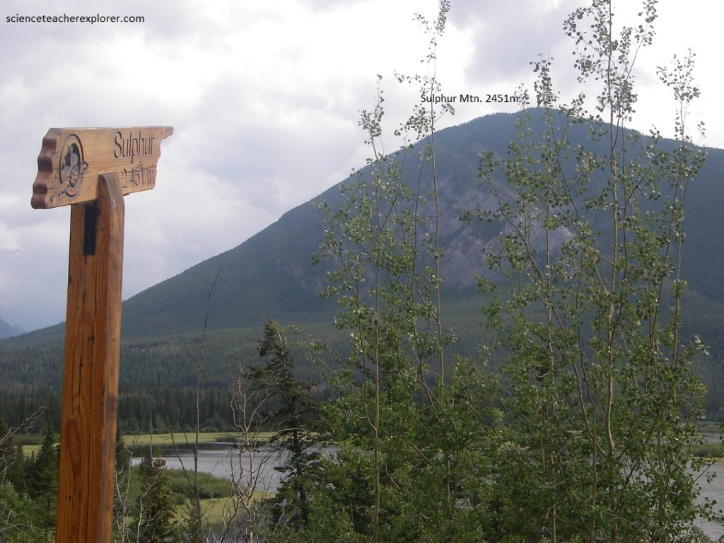
Pictured above, the green slopes with occasional struts of grey Palliser limestone mark the end of Sulphur Mountain. Just under Sulphur Mountain peak, are banded brown-weathering Banff Shales. The black (Exshaw) shale at the base of the Mississippian is clearly exposed in the gully on Sulphur Mountain, south of the gondola lift. Not far above the terminal of the gondola lift is the thrust along which the Paleozoic rocks rode over the younger, Mesozoic, rocks of the valley below. The latter, Triassic rocks of the Spray River formation. It is along this thrust and the cracks in the rocks associated with it that the Sulphur Waters of the hot springs within the Banff Village find their way.
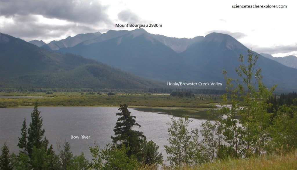
Pictured above, the valley flat of the Bow River is underlain by the sands and gravels, probably mostly glacial outwash. Numerous small pockets have been left in this gravelly plain by the irregularities of river erosion and perhaps the original glacial deposition, so that numerous small ponds and back-waters are to be seen it it. Looking westward, we can see a great mass of east-dipping limestone with layer-cake horizontal bedding behind part of Mount Bourgeau.
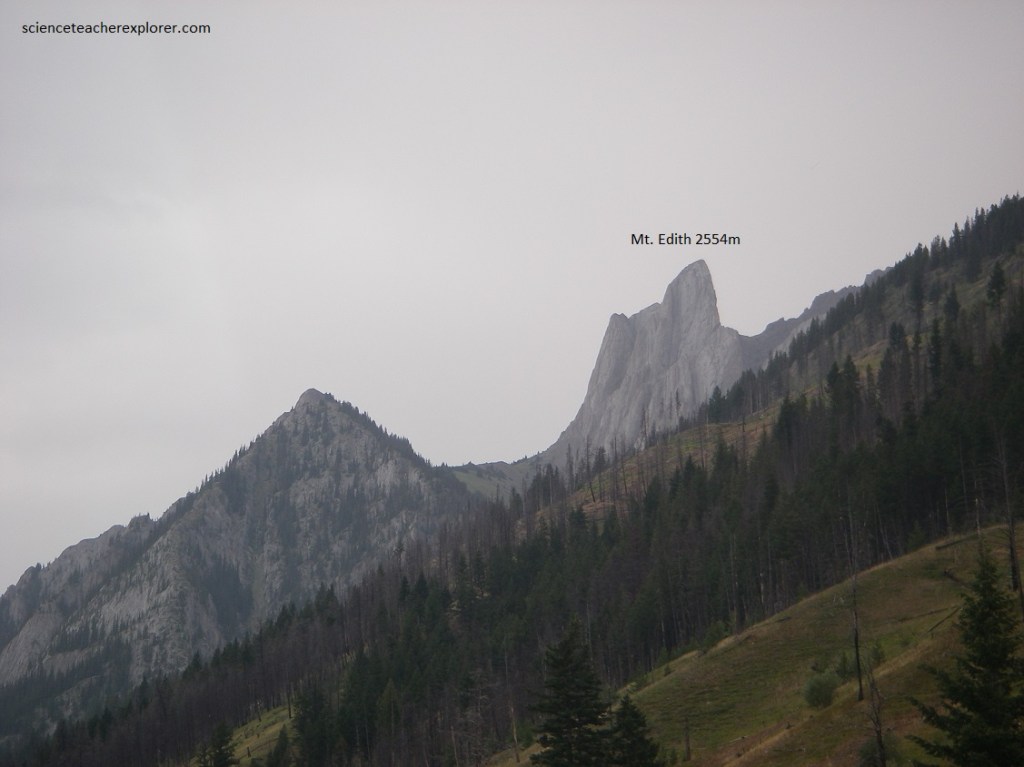
Pictured above, the vertical ribs of Mount Edith (Palliser limestone) are visible up a valley to the north, with the grey limestone of Mount Norquay to the northeast, from the intersection of the Tran-Canada Highway and Route 1A (Bow Valley Parkway). The first ridges that the Bow River cuts through in its eastward course include these vertical ribs of the Sawback Range. Sharp, jagged mountains sometimes result from the erosion of masses of vertical or nearly vertical rocks. The peaks may be centered on a bed of particularly resistant rock, in which case a tall spine or rock wall may result. Mount Edith is s spectacular example.
Pictured above and below, the rocks are now standing almost on edge in the Sawback Range that was once accumulated as flat horizontal layers beneath an ancient sea. Since these beds were thrust up on edge, erosion has produced a complex array of peaks and slopes by cutting into the rock layers, sometimes parallel to the layering, sometimes at a gentle angle across it, and sometimes directly across it. In places, we can see a conspicuous layering in the rocks reflected in a clearly marked banding in the pattern of vegetation on the mountain slopes. This is because different rock layers give slightly different growing conditions, making vegetation much more successful in some places than in others.
Pictured below, the edges of the upturned rock units form the jagged peaks and chevron slopes that have given the name to this mountain group. The high end of the near mountains in this range is Mount Ishbel. If the rocks in a long ridge are vertical, or nearly vertical, erosion may produce rows of angular mountains that look like the teeth in a saw. This type is superbly shown in the Sawback Range from Mount Ishbel southward to where the Bow River swings across the mountains near Banff.
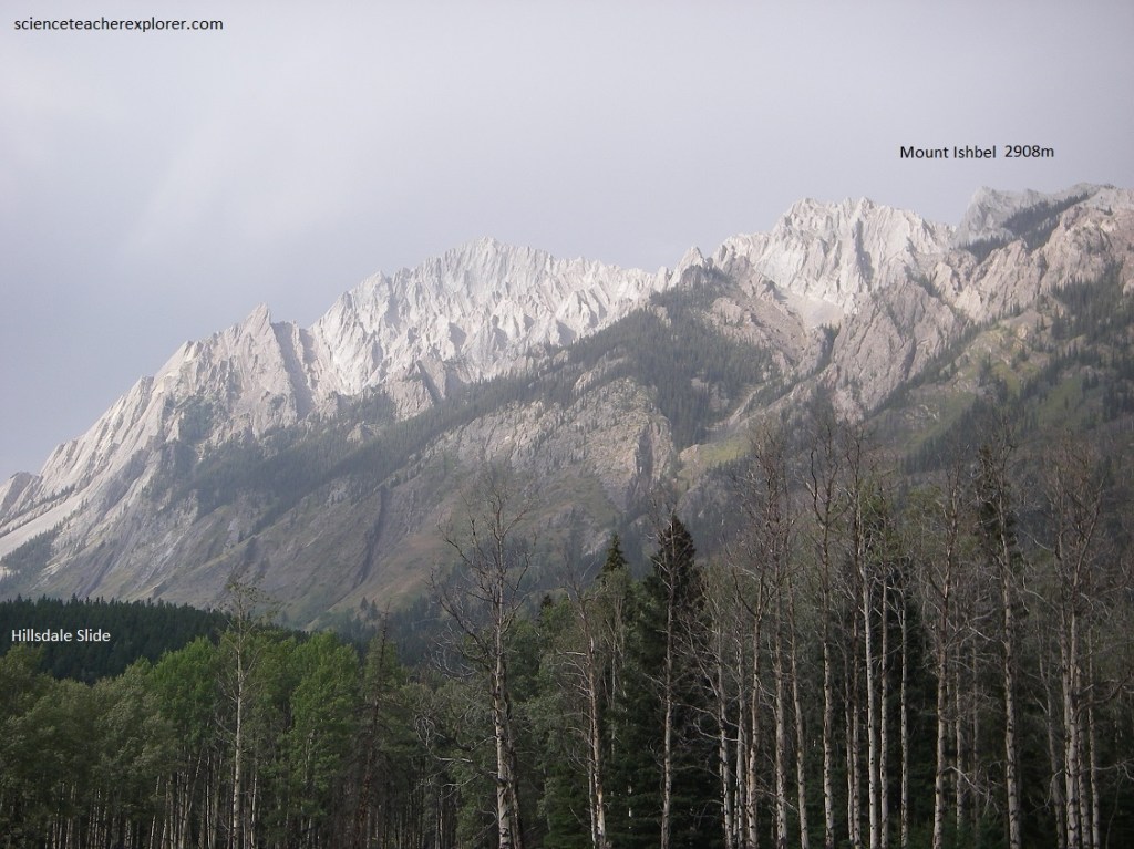
Pictured above, the distinct chevrons of the Sawback Range, with the inverted V’s of Mount Ishbel, loom over the rounded hills with their woods and open meadow. The peaks of the Sawbacks are all in rock of Mississippian and Devonian age, whereas the rounded hills and meadows are developed on later Paleozoic and Mesozoic rocks. It is interesting to note a great hole in one of the dip slopes in the limestones below and a little to the left of the peak of Mount Ishbel. Jointing in the massive limestones is in two directions, which now are more or less diagonal up and down the slopes of the limestone beds. The hole was made when a large mass of limestone became detached, then slid diagonally down and to the right along one of the joint surfaces (imaged below).
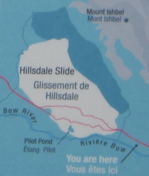
Imaged above, the waste from this slide, (Hillsdale Slide), has added an enormous bulk of broken rock to the scree slope below. Immediately below the slide, the Bow River is busily building and destroying islands of sand and gravel, with the tall straight dark spruce trees standing as mute witnesses of these activities on the valley flat just beyond.
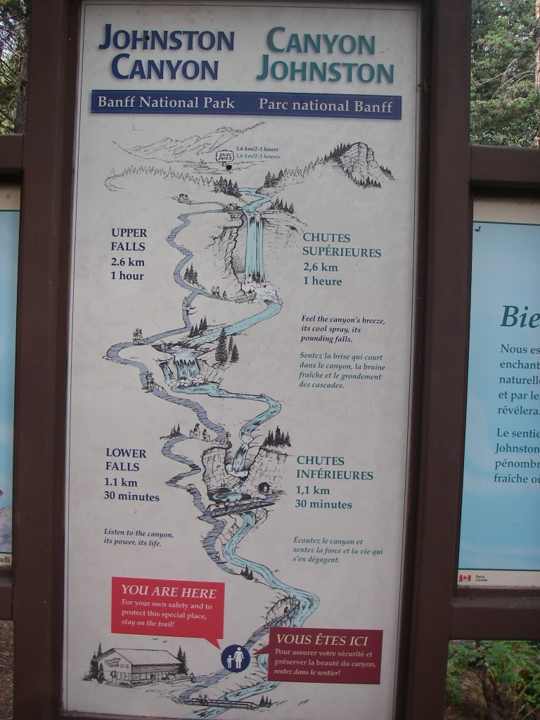
Image above, Johnston Creek rises in a valley that lies behind the Mount Eisenhower and its subsidiary ridges. After flowing parallel to the Bow River valley for more than 16 km, it turns abruptly south-westward across the trend of the mountains to empty into the mountains to empty into the Bow River a little below the highway of Route 1A.
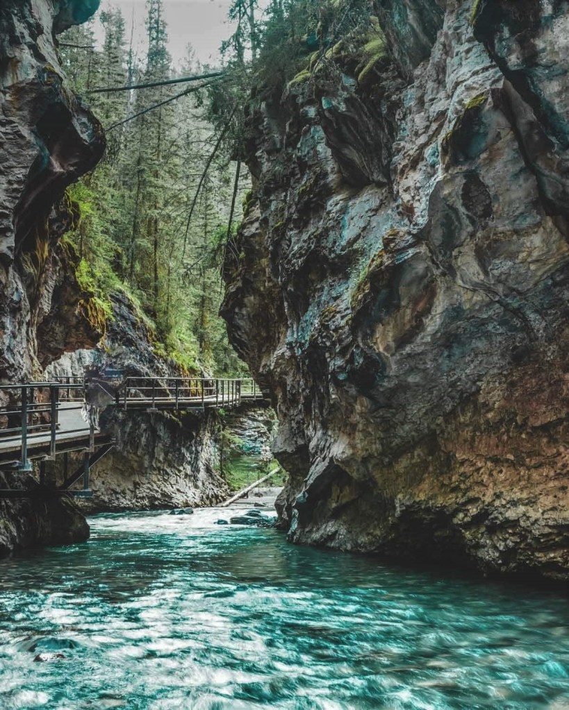
Pictured above, Johnston canyon cuts across the trend of the mountain ridges it drops through several canyons and waterfalls that provide many beautiful views. A short walk up the creek from the parking lot along and easy boardwalk takes us to some of the nearer of these features. This canyon is cut into the steep cliffs of Mississippian rock, made up of massive beds of limestone containing an abundance of fossil shell and fragments.
Pictured below and imaged above, Mount Eisenhower and the mountains to the west differ somewhat in appearance and structure from the steeply dipping front ranges (the Sawbacks) between here and the eastern park entrance. They are called the main ranges of the Rocky Mountains and it is these mountains, many of which rise to more than 3600 meters, that form the Continental Divide. Mount Eisenhower and Helena Ridge seen from here form the eastern edge of the main ridges. This range consists of rocks older than most of these in the front ranges.
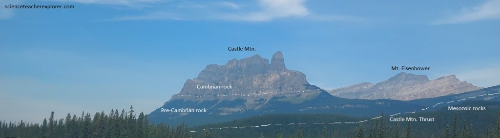
Pictured above, Precambrian rocks, purple and green, highly cemented shales or argillites, over 500 million years old, are the oldest rocks on this mountain range. They are overlain by Lower Cambrian quartzites and shales which form the dark layers below the cliffs of Mount Eisenhower and Helena Ridge. The cliffs are Middle Cambrian limestones, massive, jointed rocks that tend to break away in large angular blocks and leave steep cliffs. The same rocks for many of the peaks in this area. This mass of old rocks has been pushed up along the Castle Mountain thrust, the trace of which may be seen crossing the mountain face, (pictured above). This is one of the great thrust faults of the Canadian Rocky Mountains. The beds above the thrust faults are folded down into the trough (syncline).
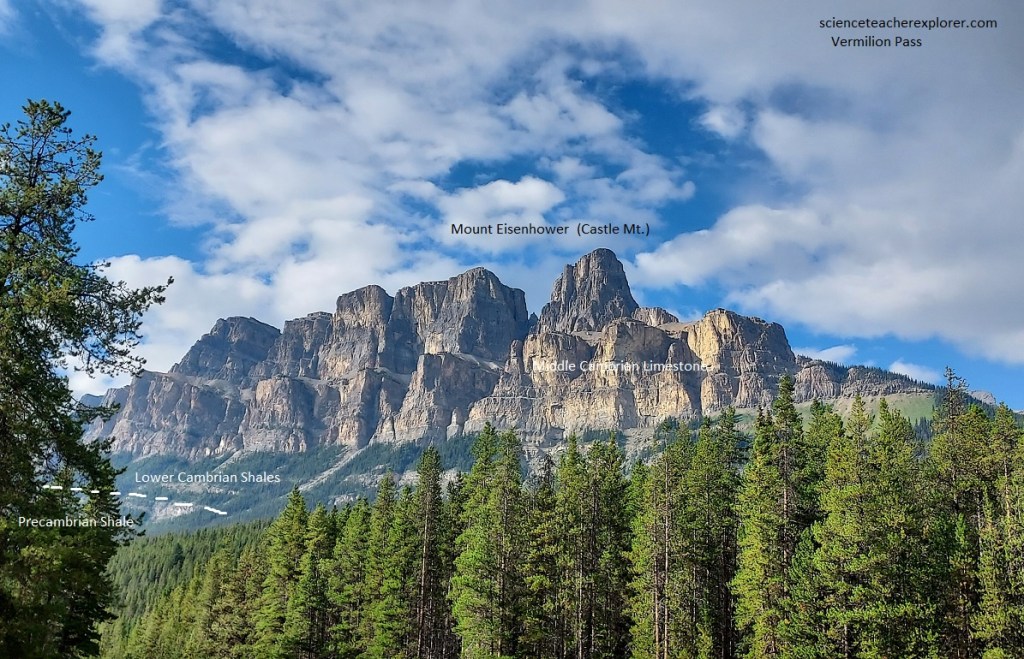
Pictured above, is the great wall of Castle Mountain displaying steep cliffs of Cambrian rocks with trees in the lower slopes and meadow above. Rock runnels show where the waste from higher in the mountain tumbles down and keeps the pathways open. As we look at Castle Mountain from here, it is difficult to realize that we are looking at the edge of a broad downfold or syncline. In the walls of the gap to the left that separates Mount Eisenhower from its northward extension, we can see the dip of the rocks, (away from us), which gives a hint to the synclinal structure.
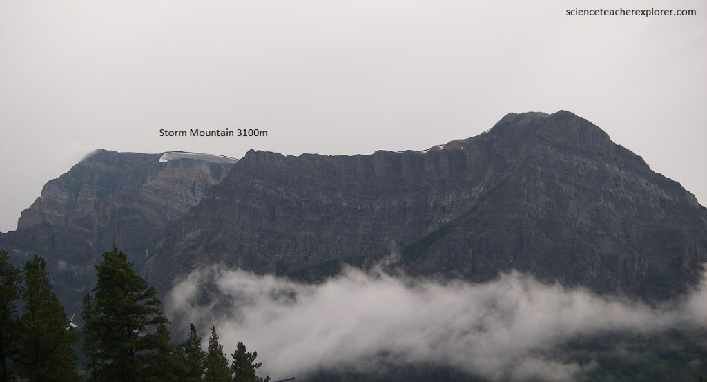
Pictured above, the mass of Storm Mountain forms the husky left shoulder of the valley that leads to Kootenay National Park. Storm Mountain is made of Precambrian and Lower Cambrian quartzites, but if we follow the dip of layers toward the left (east), we will see that they dip under its peak, which is topped by younger Cambrian limestones.
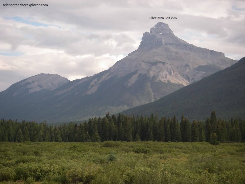
Pictured above, across the Bow River valley Pilot Mountain’s wooded lower slopes give way upwards to it bare peak. The layered snowy knob of Pilot Mountain continues to be the landmark that it is for many kilometers up and down the Bow River valley.
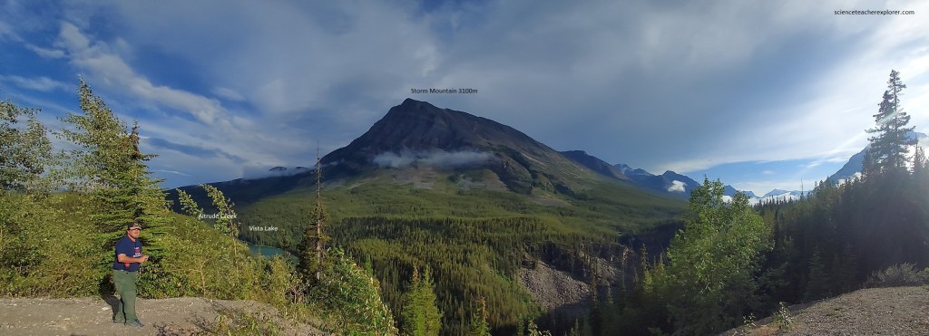
Pictured above, from the Continental Divide (Banff/Kootenay park boundary), Vista Lake les on the valley bottom far below and to the left of this viewpoint in its dark sylvan setting of forest. Opposite and lower down, remnants of a moraine loop along the base of Storm Mountain, showing that the glaciers were once here. Across the valley, Storm Mountain shows dipping Precambrian and Lower Cambrian quartzite series in its red-dish brown slopes. High and to the right of Storm Mountain is Stanley Peak with its snowy top with glaciers here and there.
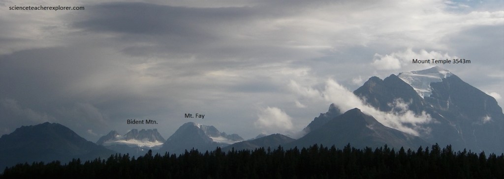
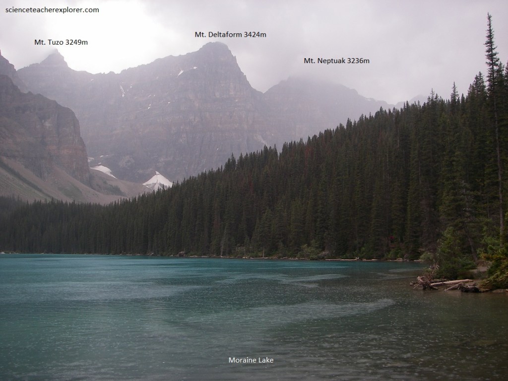
Becky and I continued onto the village of Lake Louise next to the Trans-Canada Highway. Pictured above, to the southwest of the junction, Mount Temple thrusts its peak into the sky and shows on its northeastward slope a dazzling white glacier. Farther to the right, assorted peaks with ice and snow occupy the skyline in the general direction of Moraine Lake, (our next destination). Mount Fay shows a patch of snow on its right flank and Bident Mountain (Quadra) shows one isolated peak, the a long flat but serrated skyline with snow below the serrate shoulders.
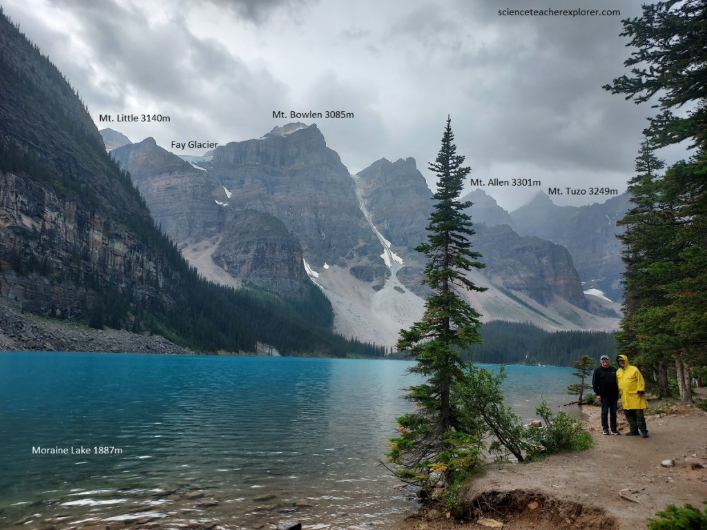
From the road that goes to Lake Louise, we turned left to explore the Valley of the Ten Peaks with Moraine Creek flowing through it. This is a hanging valley and far below may be seen the valley of Bow River and Moraine Creek winding into it. Pictured above, Moraine Lake is a beautiful gem lying in a valley carved by the glaciers among the great peaks of the Canadian Rocky Mountains.
This area is ringed by a series of peaks consisting mostly of grey and brown quartzites and slaty shales of Cambrian age. These are broken by more or less vertical joints or cracks, which have had a considerable effect on the erosion of the mountains because they allow the rock to break away from the main mass along these cracks and thus leave vertical faces. The nearly horizontal stratification in the rocks is clearly visible in almost all the peaks. It seems likely that the depression in which Moraine Lake lies began as a glaciated valley.
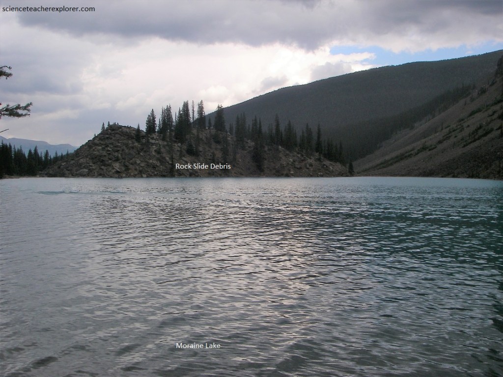
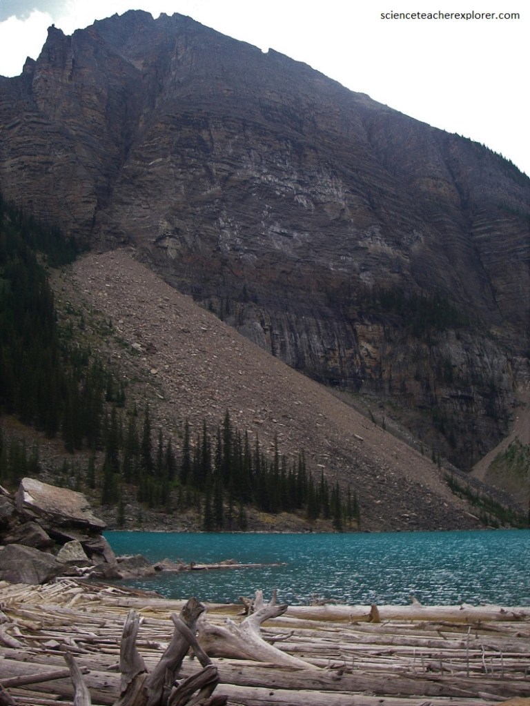
Despite its name, Moraine Lake was dammed by a landslide rather than by a glacial moraine as one would think. However, at least two landslides are represented in the heap of rubble at the end of the lake, (pictured above and below). The older has developed soil, lichens and vegetation (pictured below), whereas the younger is bare rock and has little vegetation (pictured above).
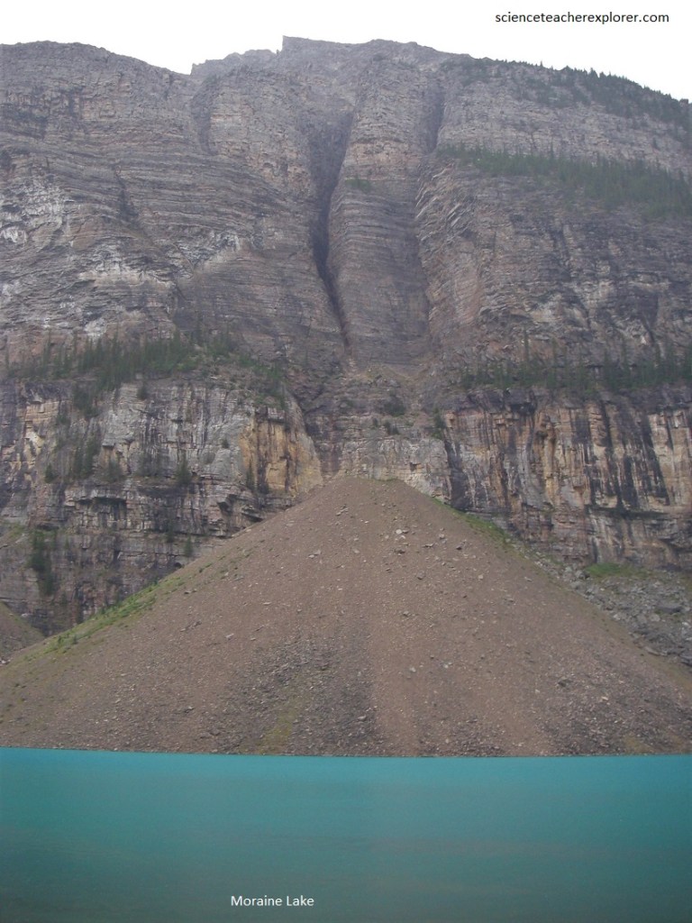
Imaged below, the sedimentary rock found in these mountains is porous. Rain water and melting snow percolated down through sandstone and limestone and along the separating sheets of shale. As they trickle into the cracks, rain and melting snow freeze and expand, splitting even the hardest rock. Loosened by repeated freezing and thawing, frost-broken fragments bounce down the cliffs and collect in cone shaped piles called talus or scree slopes.
However, the higher the source of the rock on the mountainside the farther it slid. As a result, the pinkish quartzites (highly cemented sands) from the lower cliffs are most abundant immediately under the mountain and in the talus (imaged above), whereas the purplish and green shales from higher on the mountain are nearer the parking lot.
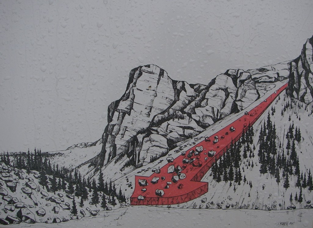
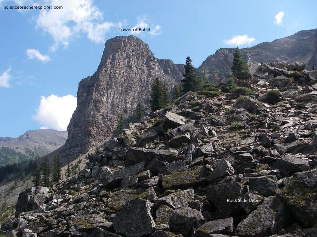
Pictured below, it is suggested that the younger rock slide involves huge masses of rocks from near the Tower of Babel (that larger tower of rock on the left of the photo below) collapsed and produced an enormous flowage of rocks which cut across the end of the lake, raising it considerably and making the present dam.
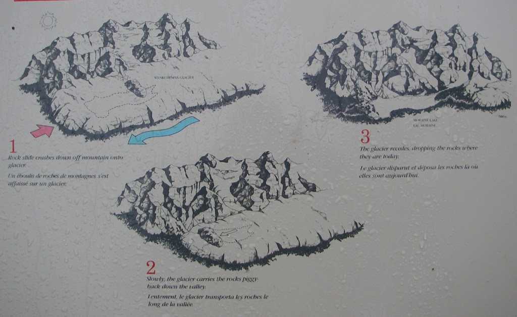
However, some scientist suggests that a temporary renewal of glacial activity produced a long tongue of ice, which picked up a good deal of landslide debris from the talus and rock-waste slopes along the lake and pushed it up into those steep masses (imaged below).
Pictured below, some avalanches sweep trees off the slopes onto the lake ice in the winter. When the ice melts, the trees drift over to the stream outlet, forming a log jam. But in this case, the log jam provides habitat for a threatened species of west-slope cutthroat trout. In the summer, the trout spawn under the logs, hidden from the eyes of predatory eagles and ospreys.
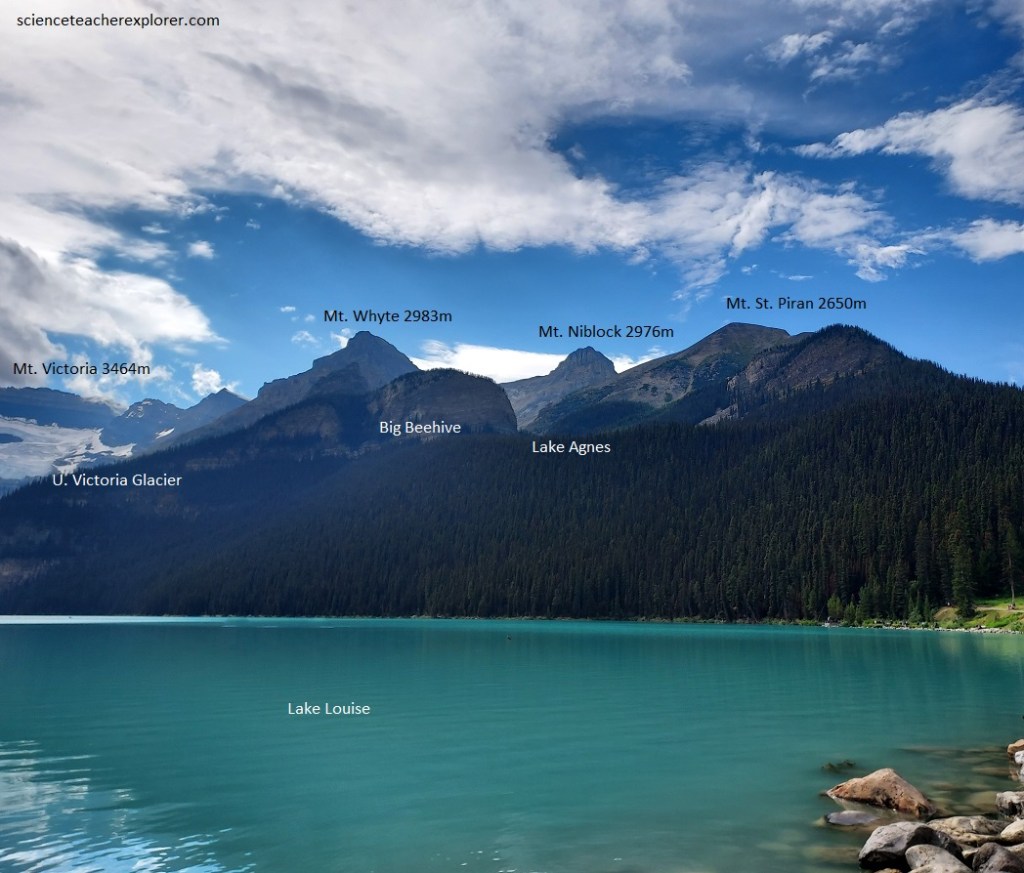
Later that morning, Becky and I explored the nearby Lake Louise. Pictured below, Lake Louise is surrounded by high mountains made up of rocks of Precambrian and Cambrian age. Precambrian rocks floor the valley at the outlet end of the lake, (where we are standing). Lower Cambrian rocks top the low knobs and Middle Cambrian forms the brown glacier-spangled cliffs of the higher mountains in the distance. Mount Victoria is capped by Upper Cambrian.
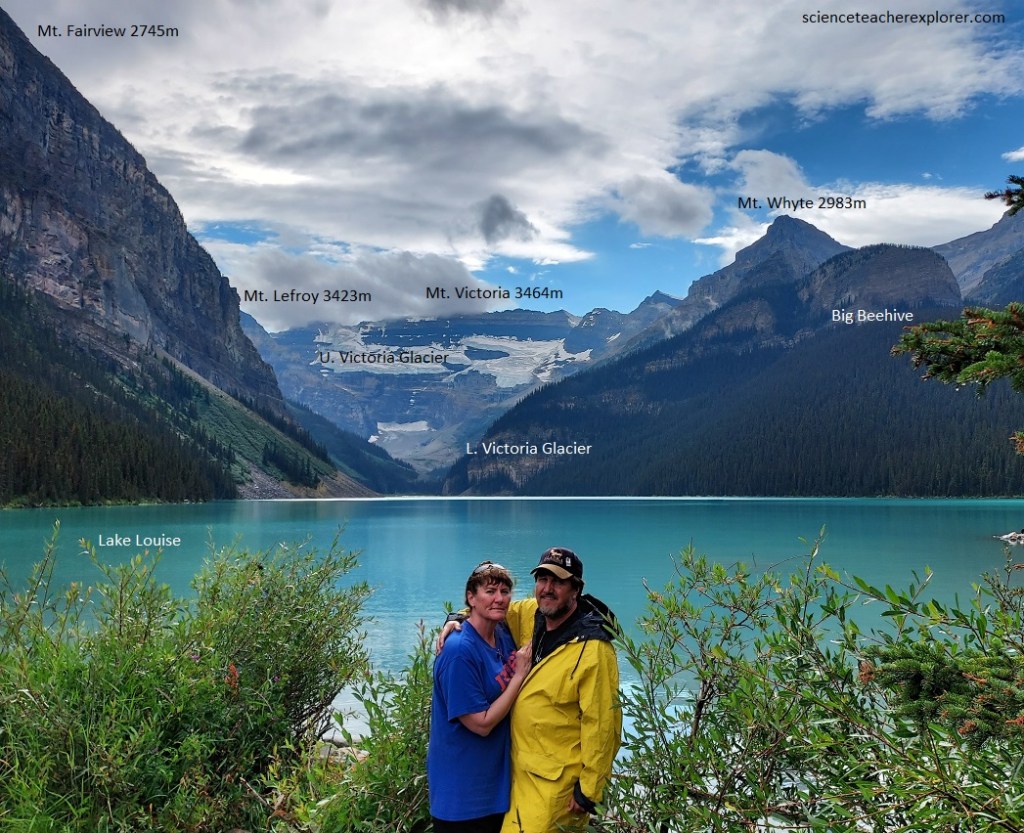
Pictured above and below, the valley containing Lake Louise is a hanging valley perched high above the Bow River. During the Ice Age, Victoria glacier extended the full length of the valley, from Victoria Mountain to the main or trunk glacier that, at that time, filled the Bow River valley below. It was fed by ice from cirques (half-bowl-shaped valleys) high in the nearby mountains. One of these cirques, Lefroy glacier, visible to the south at the far end of the lake, still supplies ice to lower Victoria glacier. Victoria glacier during the Ice Age deepened the valley and steepened the walls. Later, as the climate warmed and the ice retreated, it left the moraine ridge which dams the lake and on which the Chateau Lake Louise stand. Pictured below, Lake Agnes is in a cirque once occupied by an additional alpine glacier.
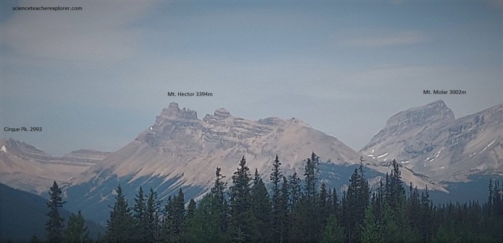
Later that afternoon, Becky and I continued our trip on the Trans-Canada Highway towards Jasper National Park. However, the Banff-Jasper highway turns off the Trans-Canada Highway and continues to follow the valley of the Bow River north by northwest to its headwaters at Bow Pass. Throughout this section of the park, the rocks that form the mountains on either wide of the Bow River valley are Precambrian and Cambrian in age. At the turn-off of the Banff-Jasper highway are outcrops of the oldest rocks in the area, the Precambrian Hector formation. These rocks are red, brown and purple argillites (hardened clay) and quartzites that were laid down by the sea late in Precambrian time. They form the lower slopes of the mountains in the vicinity, (pictured below). Above, are Lower Cambrian quartzites and shales and still higher, the massive cliff-forming light brown. Middle Cambrian limestones form the sheer brown cliffs of Mount Hector and Molar, (pictured below).
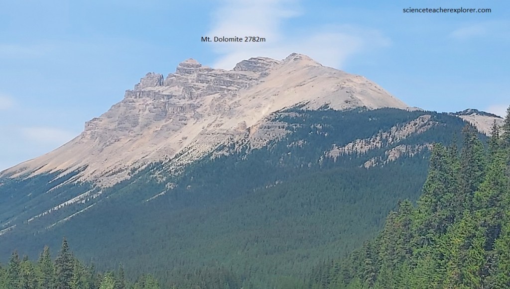
Looking northward along the Banff-Jasper highway and a little to the left, we see Bow Peak standing out prominently. Although it is really more or less detached, it looks from here to be part of the Waputik Range. It is made entirely of Cambrian quartzite. Pictured above, to the right of Bow Peak we can see the jagged brown outline of Dolomite Peak with other mountains to the right. If we think about the way the rocks dip in all these peaks opposite us and to the north, we will see the key to the larger rock structures in the area. West opposite, the rocks dip to the west away from us. In Bow Peak the rocks are nearly flat, while in Dolomite Peak they dip to the east. The combined structure therefore takes the form of an eroded anticline or upfold.
Imaged below, along the Banff-Jasper Hwy. near Bow Lake, along the east side of the valley, brownish mountains are clearly different from those on the opposite or western side of the valley. These is because they are cut in rocks that are younger than the rocks of the Waputik Range and those in Bow Peak. The distribution of the old and young rocks here is explained on the basis of the regional structure. Bow Peak lies directly on the crest of an anticline. To the west the rocks dip westward and to the east the rocks dip eastward.
Pictured below, Crowfoot Glacier sends two long fingers and a short stubby on (with the meltwater stream) over the rock surface opposite from the north-eastern shore of Bow Lake. A snowfield that is largely hidden behind the large cliffs to the south. The moraines below this photo show where the ice used to flow and fall over the cliff, become reconstituted, and then push the debris out from the cliff face itself.
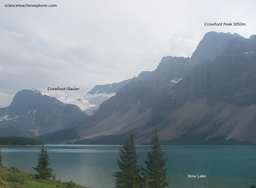
Pictured above and below, almost all the rocks in the area are quartzites of Lower Cambrian age that have a general pinkish or brownish tinge, with later Cambrian grey limestones in the higher peaks such as the one beyond Crowfoot Glacier. Southwestward, Bow Peak stands up in a pointed mass that contrasts in shape with the “long look” seen in the mountains on both sides of the Bow valley.
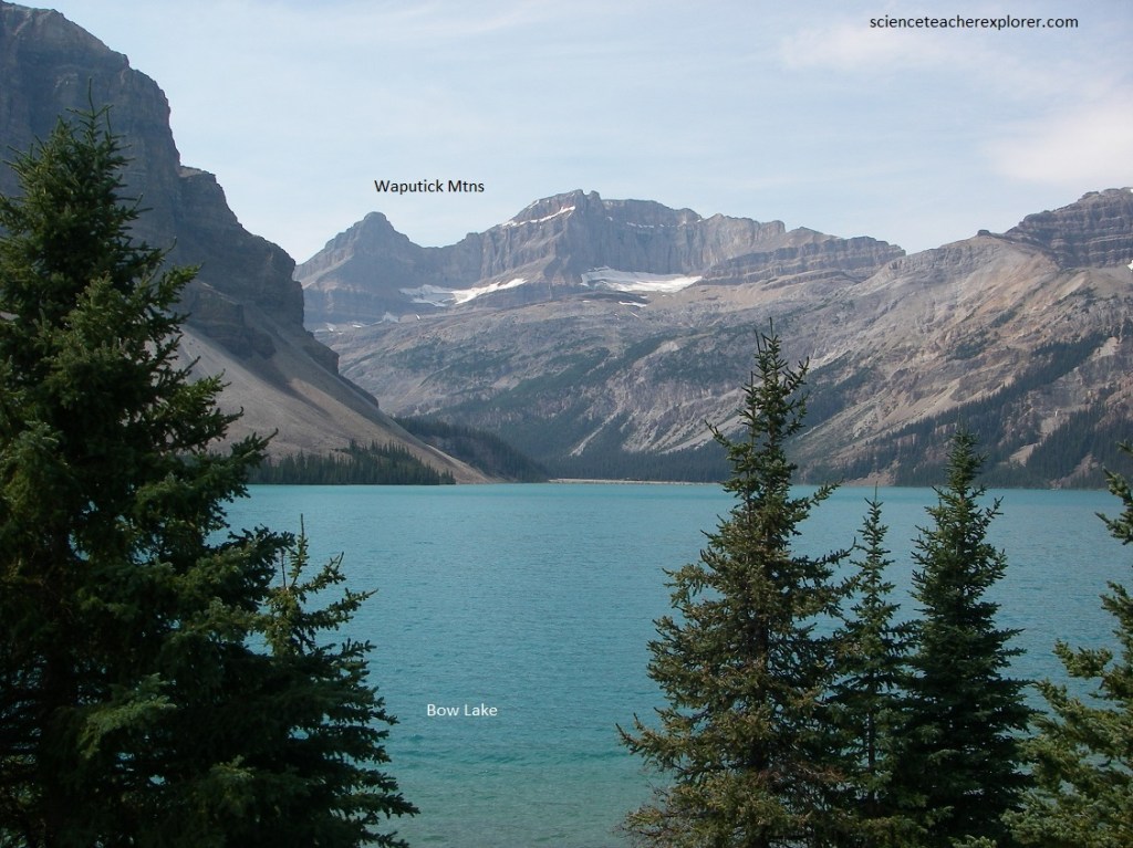
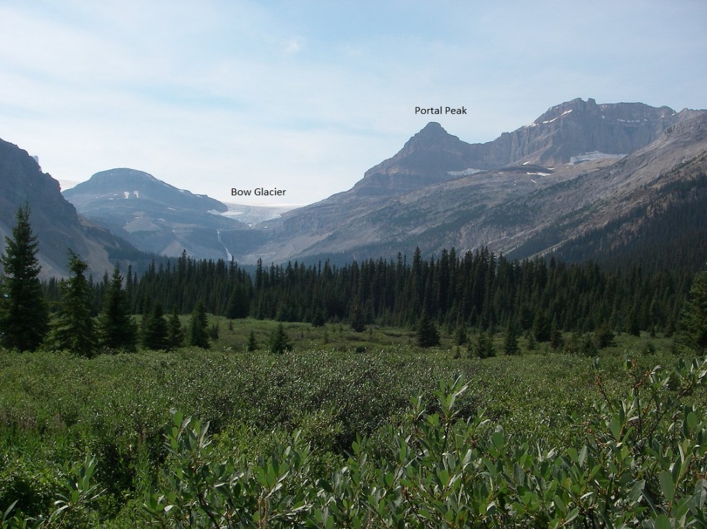
Pictured below, across and up the northern arm of Bow Lake, we can see part of a very large snowfield that covers the area of the Continental Divide here form many kilometers. At this point it sends one icy tongue, (Bow Glacier), over the cliffs, showing a rather spectacular icefall before it disappears behind the intervening lip of rock. Behind the lip lies a small meltwater lake whose outlet tumbles over the cliffs and ledges to from the curtain of whit water visible from the highway. Below this again the meltwater brook is bringing down a mass of glacial debris to build a considerable delta into the west arm of Bow Lake. Portal Peak to the right of Bow Glacier has irregular patches of ice and snow scattered along its bulk.
Pictured above, is the very beginning of Bow River, where rain and water from melting snow soak into the ground to come out a little lower down as tiny rivulets that come together to form a gradually increasing stream that enters Bow Lake from the north. Several other brooks, including the ones from the melting of Bow Glacier and those off the surrounding mountains, come into Bow Lake and add their waters to it so that the outlet of Bow Lake is larger than any of the streams above. From here, Bow Summit to the north, we will see the Mistaya River for many kilometers with various mountain peaks in the distance.
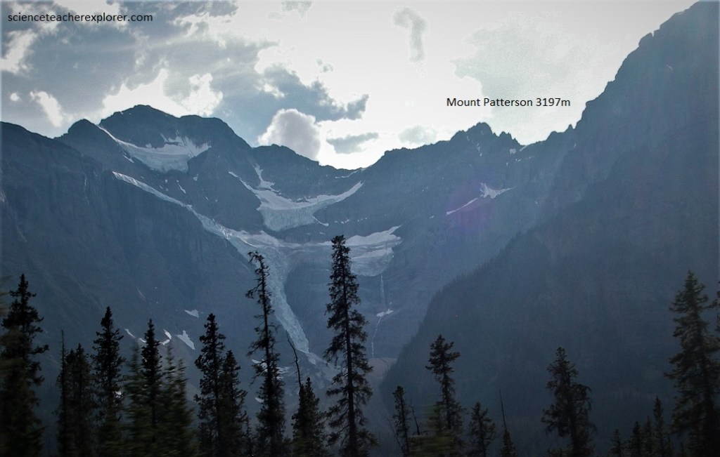
A most unusual set of masses of glacier ice with several arms and isolated bits is hung over the wall of Mount Patterson, pictured above. On the wooded lower slopes, scars of rock and ice slides through the dark trees show as bright green where small bushes and grass grow. To the right of the glaciers, one very brown rock runnel is visible in the Cambrian quartzites in the lower slopes. Well below the present ice masses, twin lateral moraines make an unusual sharp-crested horse-shoe, clearly delineating that the many bits and arms of the glacier above were once part of a larger glacier that occupied the whole of the steep-backed glacier cirque.
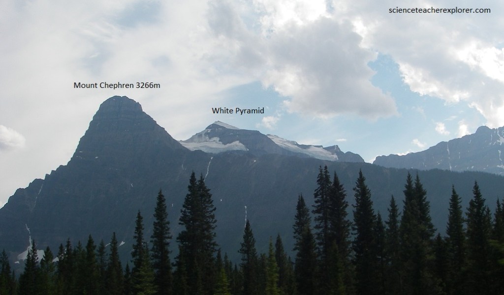
Pictured above, Mount Chephren shows its very distinctive peak, with a steep front but not quite so steep back. Its shape and marked horizontal layering make a landmark that is visible for many kilometers. Mount Chephren is conspicuously layered, with dips inclined very gently toward the west. The lower part is made of quartzites of Lower Cambrian age. Higher up in the peak, the quartzites give way to grey limestone that extends all the way to the tip. We can see a back peak a little to the west, (the White Pyramid), made entirely of the grey limestones that slope gently westward, consistent with those in the tip of Chephren itself.
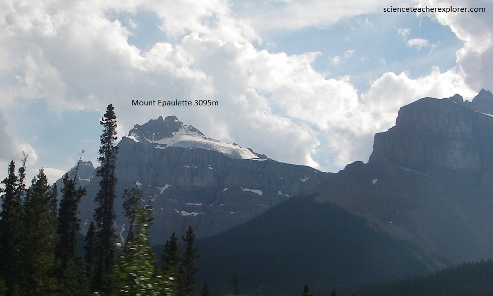
Pictured above is Mount Epaulette with glaciers on its westside, in the saddle and on ledges. It is largely made of grey and buff limestones of Middle and Upper Cambrian age and may even include some Ordovician rocks at its top.
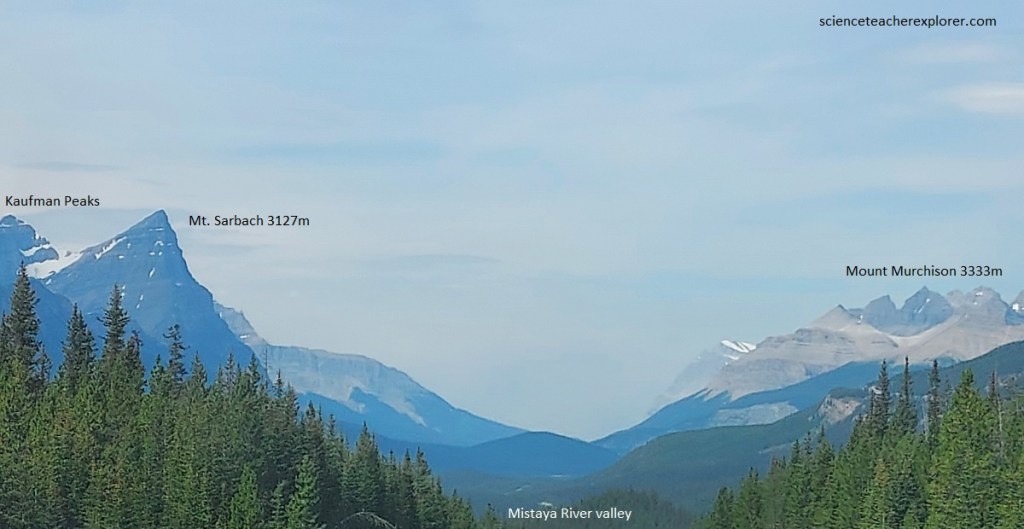
Pictured above, high above us to the east lie the enormous grey and yellow cliffs of Mount Murchison, a huge mass of Cambrian and Ordovician rocks on the eastern flank of the great anticline along which the valleys of the Mistaya River and the Bow River, far to the south, are located. Opposite to Mount Murchison is the long line of the Kaufmann Peaks that exhibits Middle and Upper Cambrian limestones, with some Ordovician rocks in the top parts.
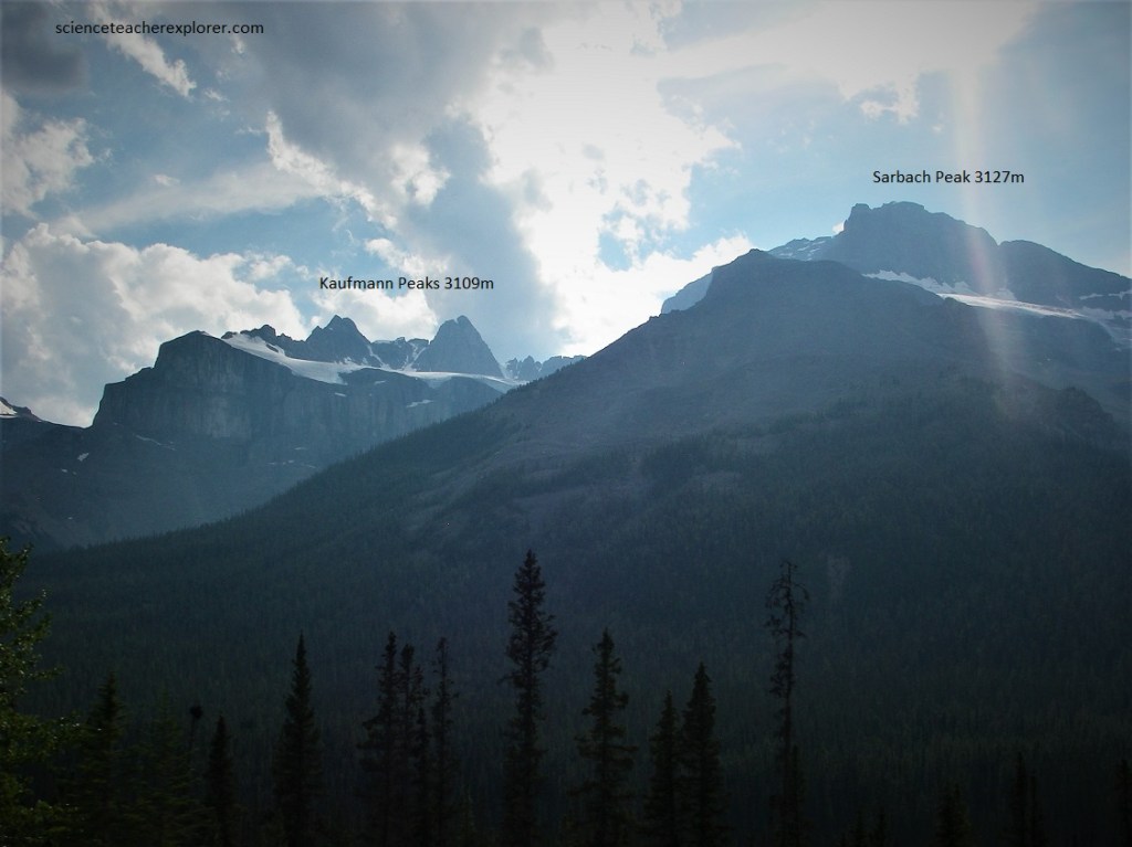
Pictured above, behind and up the hill, the great limestone walls of the Kaufmann Peaks end to the right in Mount Sarbach, with several lovely glaciers hanging on the upper slopes. Mount Sarbach is the “type locality” for some of the Ordovician rocks of Banff National Park, with its lower slopes in Upper Cambrian rocks.
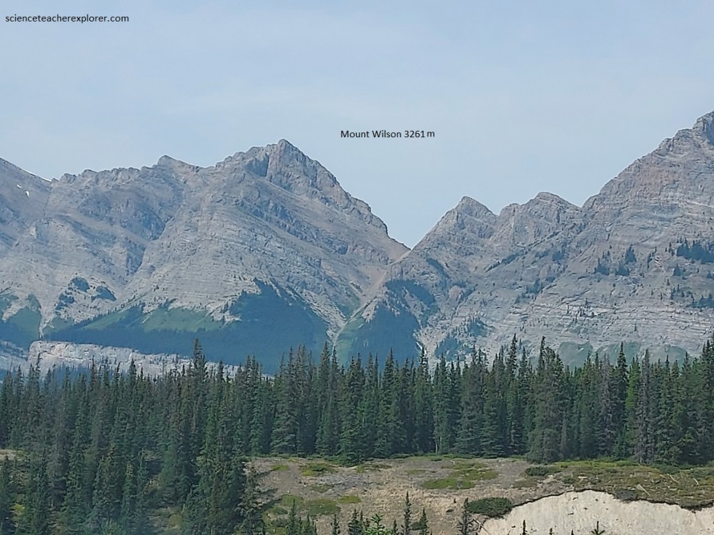
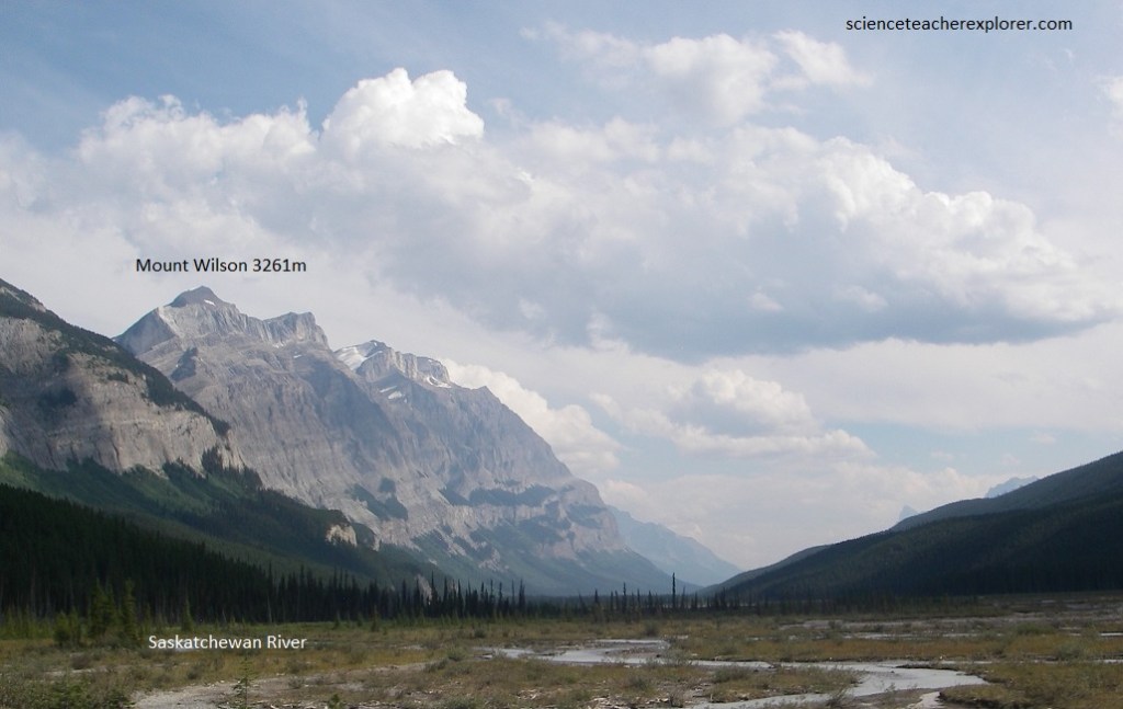
Across the valley of the North Saskatchewan River, which, on joining with the Howse River swings abruptly to the northeast from its prevailing south-easterly course, we will see the great bulge of Mount Wilson, (pictured above).
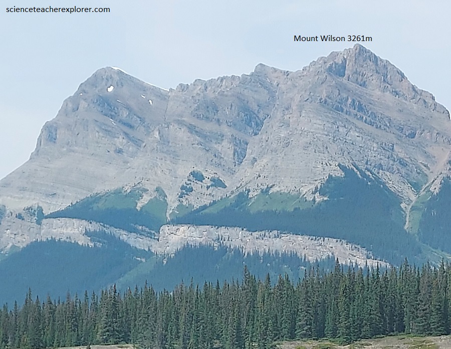
Pictured above, we can see stripes of green vegetation parallel to the rock formations alternating with great grey cliffs. This is because the rock units are different from layer to layer; the massive limestones break off to form the cliffs, and the softer, more shaly layers weather more rapidly to form chip-covered scree slopes, which in some places allow vegetation to take hold. The rocks there dip east on the east side of the anticlinal structure that the main valleys of the North Saskatchewan and Mistaya rivers follow.
Pictured above, a little farther down the hill along the highway, we could see exposed in the cut-through flanks of Mount Wilson the synclinal structure to the east, with a conspicuous valley occupied by Owen Creek just about on its axis. The great rugged cliffs of Ordovician rocks along the face of Mount Wilson form the backing to the highway. Towers of white Mount Wilson quartzite of Ordovician and limestone of Devonian age are visible in the very tips of the peaks on Mount Wilson.
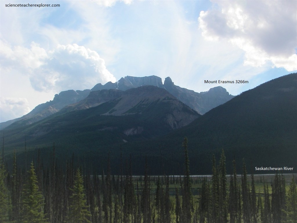
Pictured above, the peaks of Mount Erasmus are composed largely of Upper Cambrian and Ordovician rocks. From the Saskatchewan River Crossing the Banff-Jasper Hwy. follows North Saskatchewan River valley, a deep valley, U-shaped but narrower than the valleys of the Mistaya and Bow rivers to the south. It, like the latter, also carried a glacier during the Ice Age.
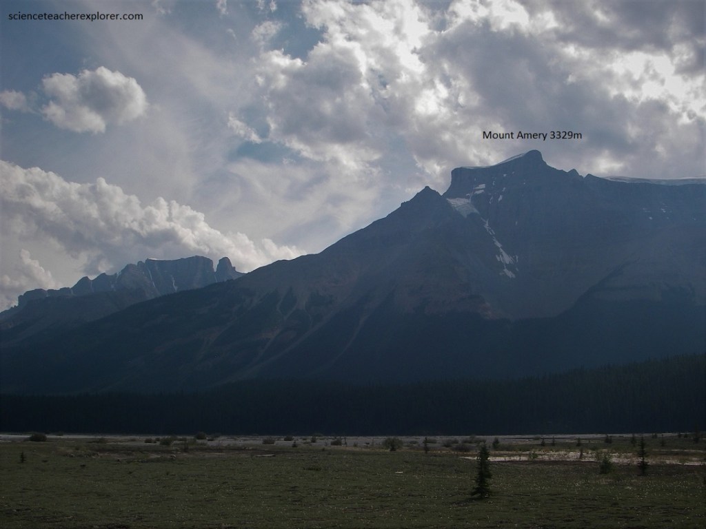
Pictured above, on the south side of the Alexandra River valley, Mount Amery rears its horizontally layered, flat-topped, cliffed summit. This mountain lies at about the axis or crest of the anticline or upfold that the road follows along, and just east of , for tens of kilometers. For this reason the rocks in it, being of Cambrian age, are older than those on either side and are flat-lying. On Mount Amery’s flank a very deep valley cuts into the brownish and greyish (upper) slopes, making a horseshoe-shaped ring of mountains.
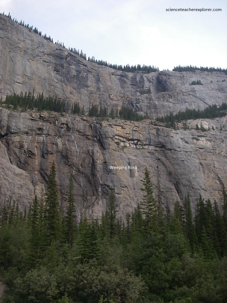
Pictured above, several little creeks come over the edge of the enormous cliff of grey Devonian limestone and fall more than one hundred meters in a series of sheer falls, interrupted by ledges along which water flows a short distance and then tumbles over again.
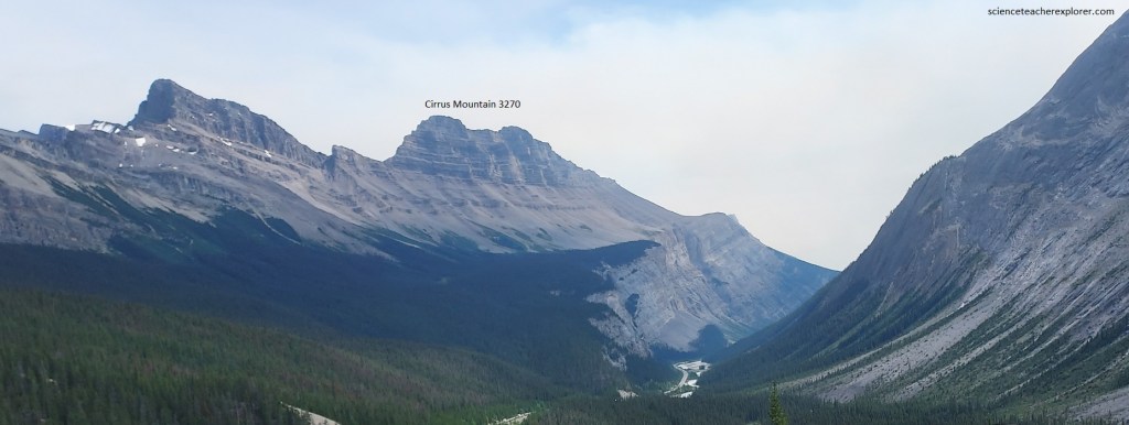
An amazing view of the syncline in Cirrus Mountain is offered from the Banff-Jasper Hwy. on the Parker Ridge, (pictured above). The valley of the North Saskatchewan River leads southward into the distance. Far below, it passes under the great cliffs of Devonian limestones with the Alexo Formation and Fairholme Group in the lowermost slopes, and the major part of the very steep upper cliffs in the Palliser limestone. The upper slope of the Palliser limestone forms the clearly shown shoulder, above which lies the more gently weathering brownish Banff shale, of Mississippian age. The top peaks of the mountain are again in grey limestone, (the Mississippian Rundle limestone). Additionally, we see that the rocks on the southwestern end of the mountain dip generally eastward while those on the other end dip generally westward, and the trough-like synclinal arrangement is clear, (imaged below).
Below Parker Ridge, the clear water of Nigel Creek contrast with the much muddier silt-laden water of the North Saskatchewan to the right. On the western of the valley, enormous dip slopes of grey limestone have vast fans of debris below with great boulders and chunks of limestone showing on the surface.
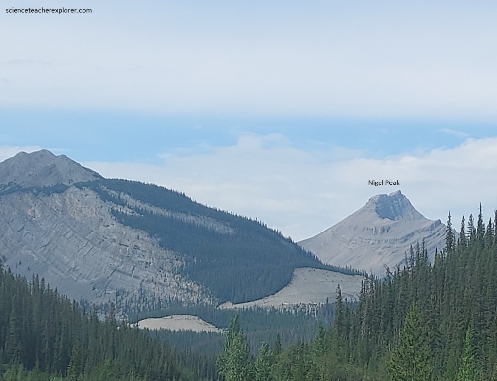
Pictured above, a high knob, Nigel Peak, lies just to the right of center along the valley, more or less on the center of the syncline or downfold. Westward, Nigel Peak dips on its right flank and the peak next to it are clearly visible. As we follow left, we can see the dips flatten and change to the east. The low left flank of the hills shows clearly its eastward dip. The fold in Nigel Peak is the same synclinal structure visible in Cirrus Mountain to the south and is, in fact, the same syncline seen off and on along the Banff-Jasper highway all the way south to the Mount Eisenhower area. Nigel Peak itself has the Rundle limestone on top with the brownish Banff shale in the intermediate slopes and the grey cliffs below forming a wall along the valley in the Palliser (Devonian) limestone.
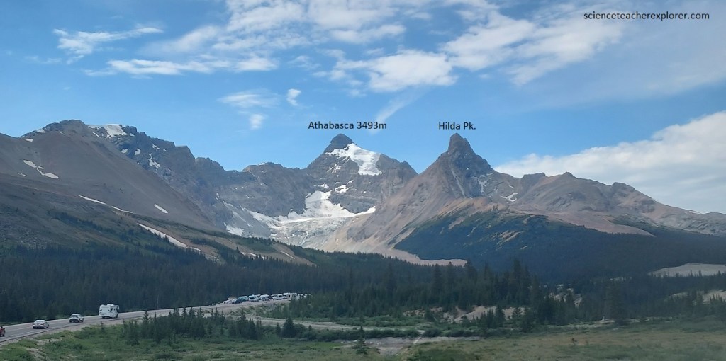
Pictured above, Mount Athabasca is a partial matterhorn-like spike left by the carving of bowl-shaped cirques by glaciers on its flanks. One of these cirques, with a glacier in the bottom, lies right below the peak and to the left.
