Yoho N.P., B.C. 2022
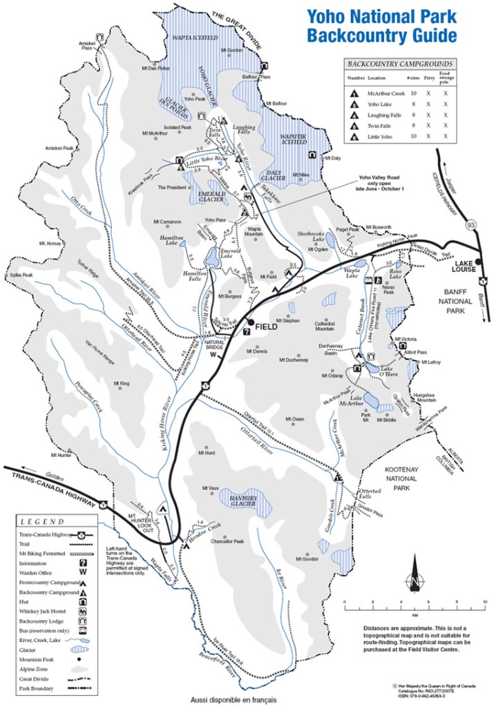
In August of 2022, Becky (my wife) and I took a road trip to Canada from our home in Idaho. While there, we visited several of the National Parks with the Canadian Rocky Mountains. One of the Parks, we visited was Yoho National Park. Yoho National Park is essentially the drainage basin of the upper Kicking Horse River and its tributaries. The park lies wholly within the Province of British Columbia, adjoins it on the south; and Banff National Park, in Alberta, adjoins it on the east, imaged below.
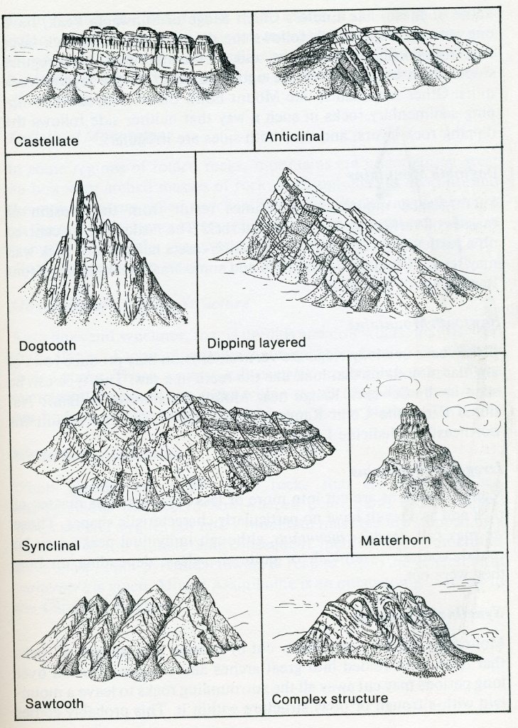
Yoho National Park is 1328 square kilometers of spectacular scenery on the west slope of the Canadian Rockies. The surface of the land presents an extremely rough and varied scenic scenes. Mountains of many different shapes and sizes stand high above deeply incised valleys. The mountains are sculptured from great up-arched or masses of rock which formed from sediments laid down in the seas that covered the area some 500 million years ago, in the Cambrian Period. In some places the rocks are lying flat, even in the highest mountains; in others they are standing on edge. Deep etching of this irregular mass has resulted in a great array of mountain types, (from those with sharp jagged peaks to those resembling castles). The sides of the mountains, extending as they do through thousands of meters vertically, expose many varieties of sedimentary rocks. And some of these contain preserved fossils from the Cambrian Period.
Becky and I decided to start at the east gate and work west. Our first stop was the historical “Spiral Tunnel” viewpoint on the Yoho Valley Road.
Prior to 1908 Hector and Field stations were separated by such extreme grades that four consolidation locomotives were required to haul a trainload of freight over this section. For about three miles a grade of
4.5 per cent prevailed – ten times the maximum gradient normally permitted on heavy prairie work. By the construction of these Spiral Tunnels this grade was reduced to 2.2 per cent.
From the east, the track enters Tunnel No. 1, 1,069 m in length, turns under Cathedral Mountain at an angle of about 250 degrees on a 191 m radius, passes under itself and emerges at the opposite portal 18 m lower. Tunnel No. 2, under Mount Ogden, has a similar radius through an angle of 232 degrees; it is 963 m long and the grade produces a difference in elevation of about 15 m between portals. Thus the railway traverses the valley by three lines at different elevations’ and crosses and re-crosses the Kicking Horse River by four bridges. Two engines can now haul a bigger load up the valley than the four previously used.
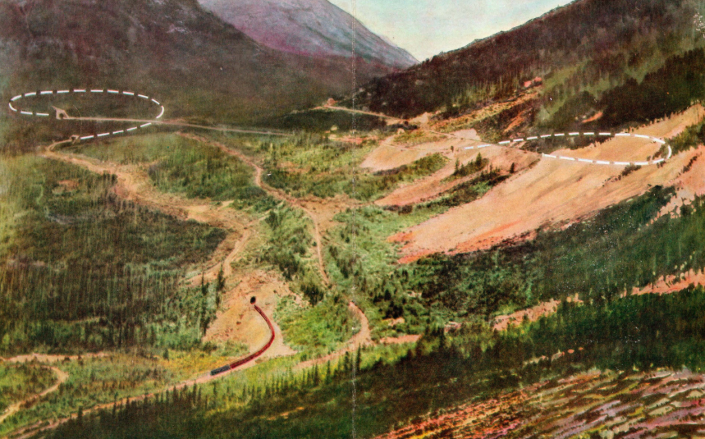
The two tunnels are a perfect maze, for the railway doubles upon itself twice and forms a rough figure “8” in shape. If the train is run in two sections, passengers are able to see the other section making its way up
“the big grade” at a higher or lower level.
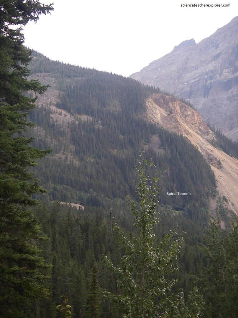
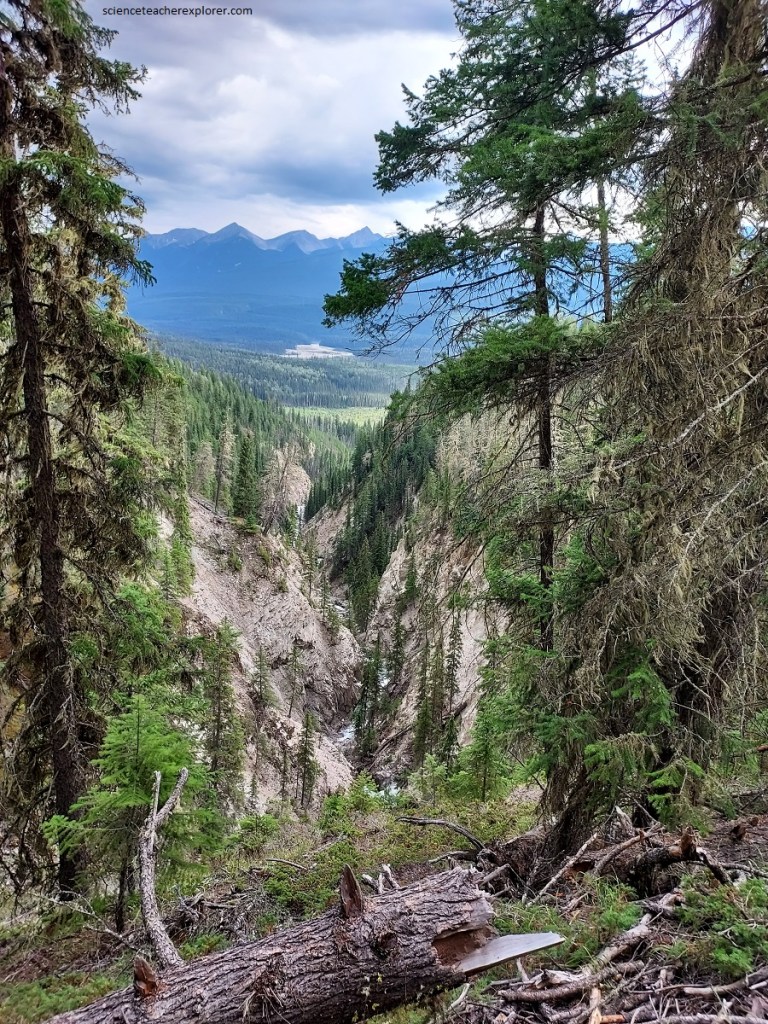
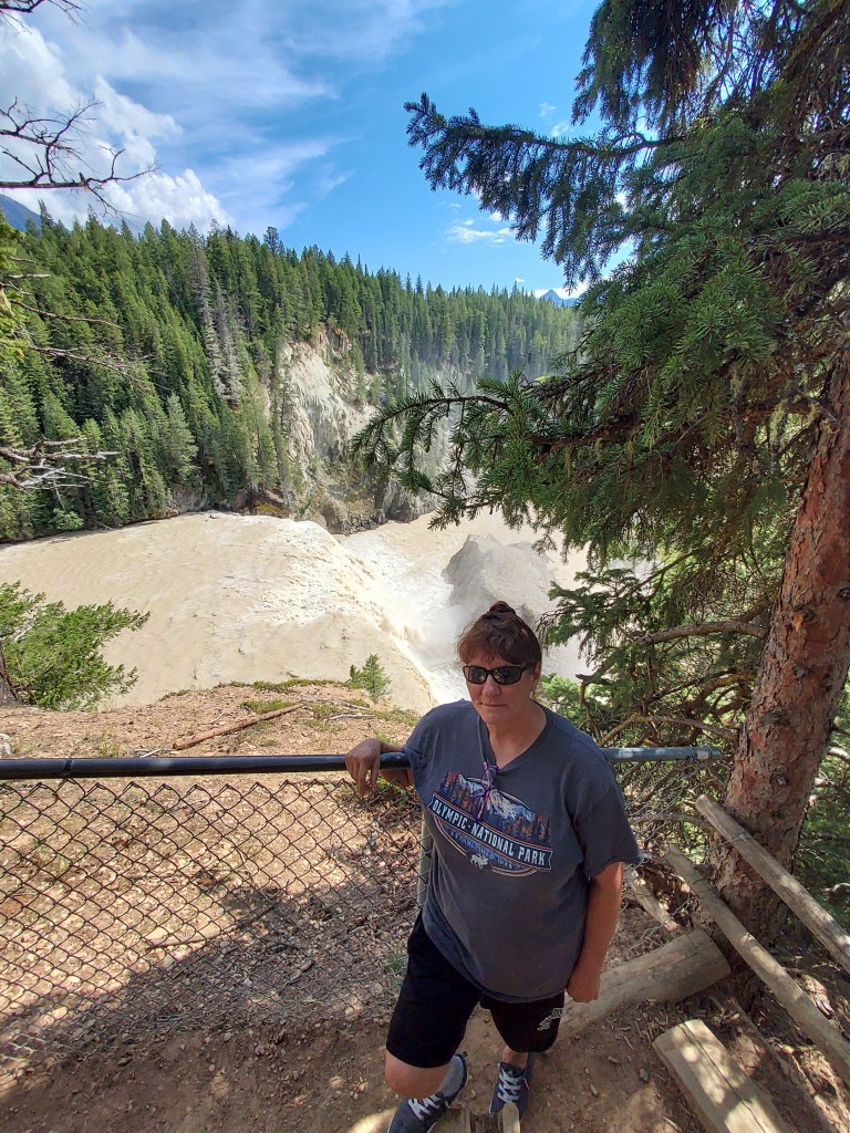
Pictured above, the beautifully braided valley flat of Kicking Horse River shows how enormous quantities of debris have been fed into the waters of the river and spewed over the valley bottom. High above us to the south, the beautiful Cathedral Crags are cut into nearly flat lying sedimentary rocks. The same layering in any one peak can be clearly seen in the others, so it is apparent that the crags have been cut from what at on time were continuous and more extensive layered rocks.
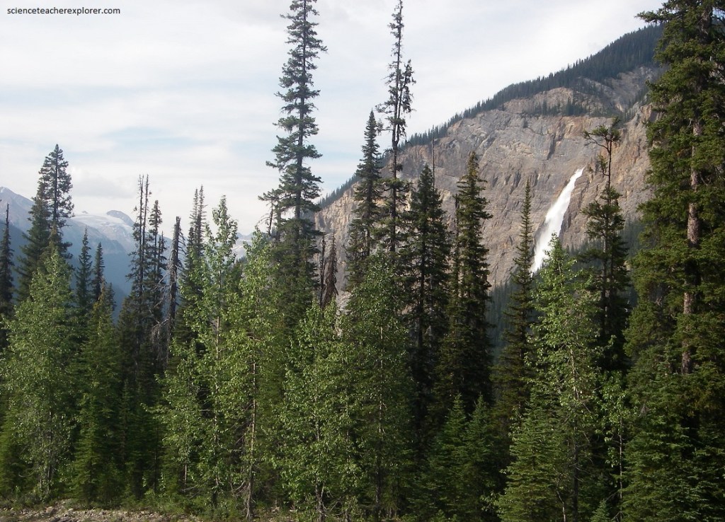
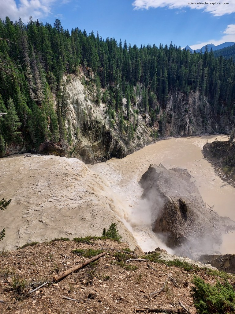
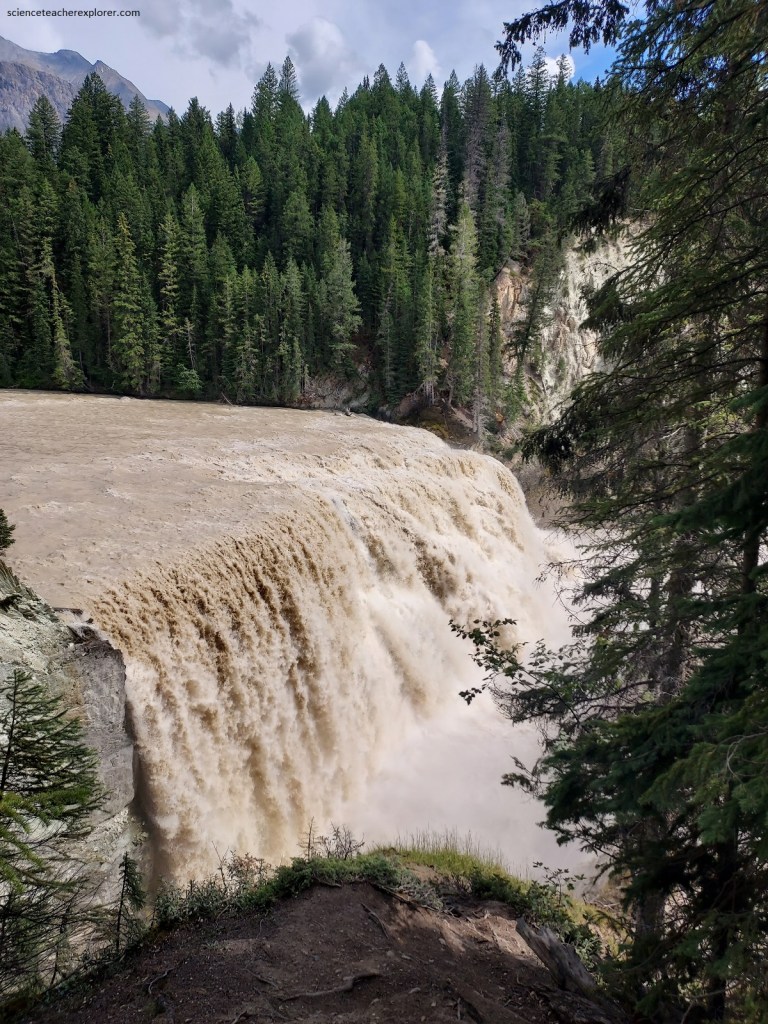
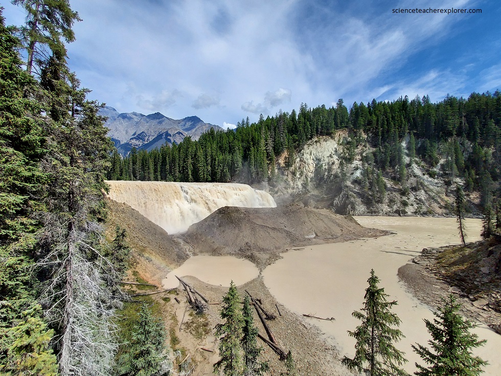
Our next stop up the Yoho Valley Road was Takakkaw Falls. One of the most spectacular sights in Yoho National Park is Takakkaw Falls, as it plunges several hundred feet over a nearly vertical cliff into a flat-bottomed valley, (picture above and below). Large snowfields and glaciers can be seen at the far end of Yoho River valley, (they supply the water to Yoho River). The sharp point of Yoho Peak sticks up in the middle of this white mass and separates the Glacier de Poilus on the left from Wapta Glacier and Yoho Glacier just to the right.
After a very long period, during which great valleys were carved and the main outlines of the mountains as we know them were shaped by the action of running water, there came a period when the whole of northern North America was covered by a great ice-cap. This period of glaciation began about a million years ago and lasted until quite recent times, perhaps 10,000 years ago. A great tongue of ice, with its head in what is now Wapta Glacier, pushed down the valley that is now occupied by Yoho River. This glacier moved down a valley which had been carved by the ancestor of Yoho River in even more distant geological times. In fact, the last glaciation of the area was but a repetition of former sequences in the history of the development of this valley.
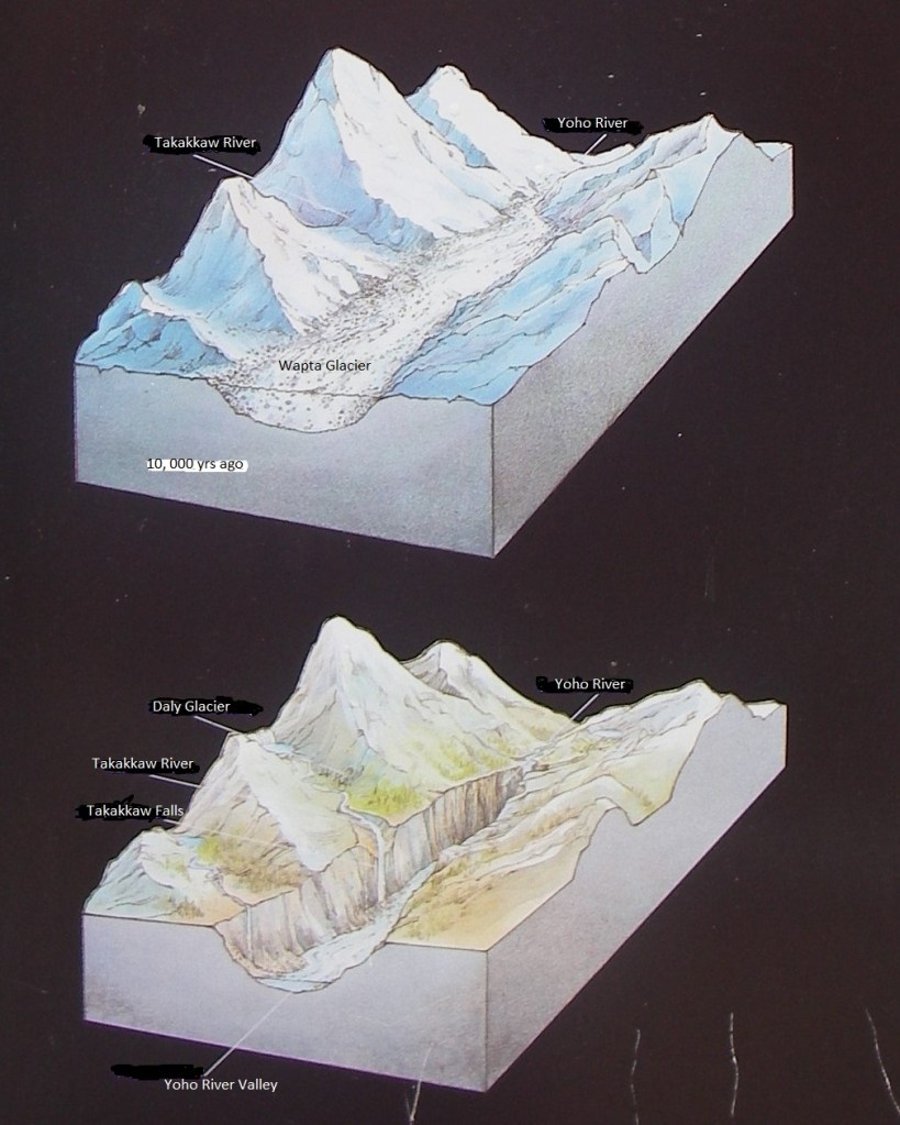
Imaged above, glaciers tend to make U-shaped valleys from the ordinary open-V shape of river valleys by steepening the walls and flattening the bottoms. Glaciers cut even harder where spurs of rock stick out into the old river valley and thus make even higher cliffs on the valley sides at these places. It is because of the steepening of the main valley wall by the glaciers and the making of great cliffs on its sides that Takakkaw Falls is there. Back on the hill and out of sight to those on the valley floor the Daly Glacier comes down from the Waputik Icefield on even higher ground near the continental divide. We find the end of the glacier at the place where melting balances the forward motion of the ice. From this ice-front there issues a stream of meltwater which, following the natural contour of the land, eventually finds its way to the edge of the great cliff and then leaps to the valley floor below.
Running water is an erosive agent, so the brook has carved a small gorge since the time that this meltwater first began flowing over Takakkaw Falls.
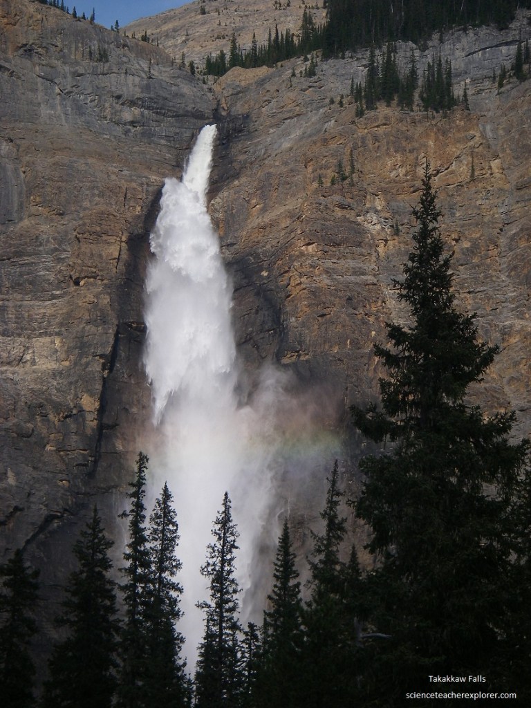
Pictured above, it is interesting to note how the water breaks into individual droplets as it falls through the air below the crest of the falls, until at the bottom the water is only a mass of heavy spray which moves back and forth at the whim of the winds and creating the rainbow. However, the water trickles among the boulders of the talus slope at the foot of the cliff and gathers together once again to form the rushing creek which finally joins the main Yoho River near the parking place.
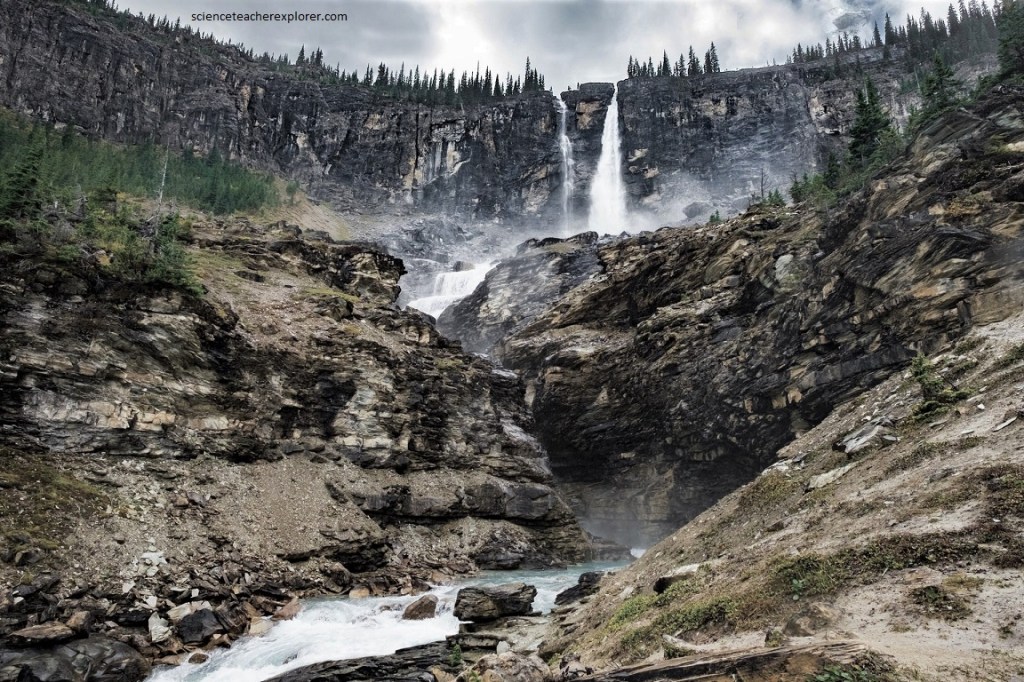
Further up the trail (a 16.4 km hike) from Takakkaw Falls, is Twin Falls. Pictured above, two falls occur side by side in the northern end of Yoho Valley, presenting one of the most beautiful sights in all of the Rocky Mountains. Perhaps a joint system, or layering in sedimentary rocks, or accidental glacial scour will have made places where a river splits and flows around a small island to rejoin on the other side. This happened in the Twin Falls Creek. Here, the split happens right on the edge of a very high rock wall. The beauty of this spot owes a great deal to the glaciers both past and present, for it is the meltwater of the present Glacier des Poilus that supplies the creek itself and it was the great glacier in the main Yoho Valley long ago which cut the huge cliff over which the falls now tumble. Much of the great heap of angular fragments and rock rubble at the foot of the cliff has been sprung out and wedged out by frost action in recent times.
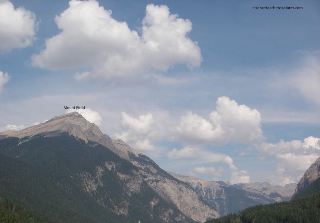
Becky and I drove back down the Yoho Valley Road and then continued southwest on the Canadian Highway #1 to the townsite of “Field” (4 km). Field is directly opposite and across the bridge over Kicking Horse River. Looking north, and on the west side of the valley the bulk of Mount Field frames the immediate view, with the flank of Mount Wapta beyond it. Still farther north along that side is the dazzling white of Emerald Glacier and the snowy mountains of the President Range.
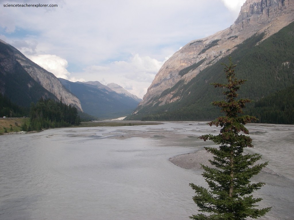
Pictured above, the valley bottom from the mouth of Yoho River to beyond the village of Field shows a splendid example of a braided river. Braided streams result from the heavy overloading of river waters with debris. They are especially common in regions of recent glaciation where fast-flowing streams pour off steep mountain-slopes into flat-bottomed valleys. Great quantities of loose glacial rubble of all sizes, (from huge boulders to fine silt and clay), are washed rapidly into the stream valley below where the slower-moving river is inadequate to handle the load. The river flowing in the debris-choked valley bottom splits and rejoins in a great number of channels as it wanders over the deposits of its own making. In times of heavy flood much of the valley may be covered with water at any one time although the main thread of the current splits and rejoins, following the same pattern as in times of low water.
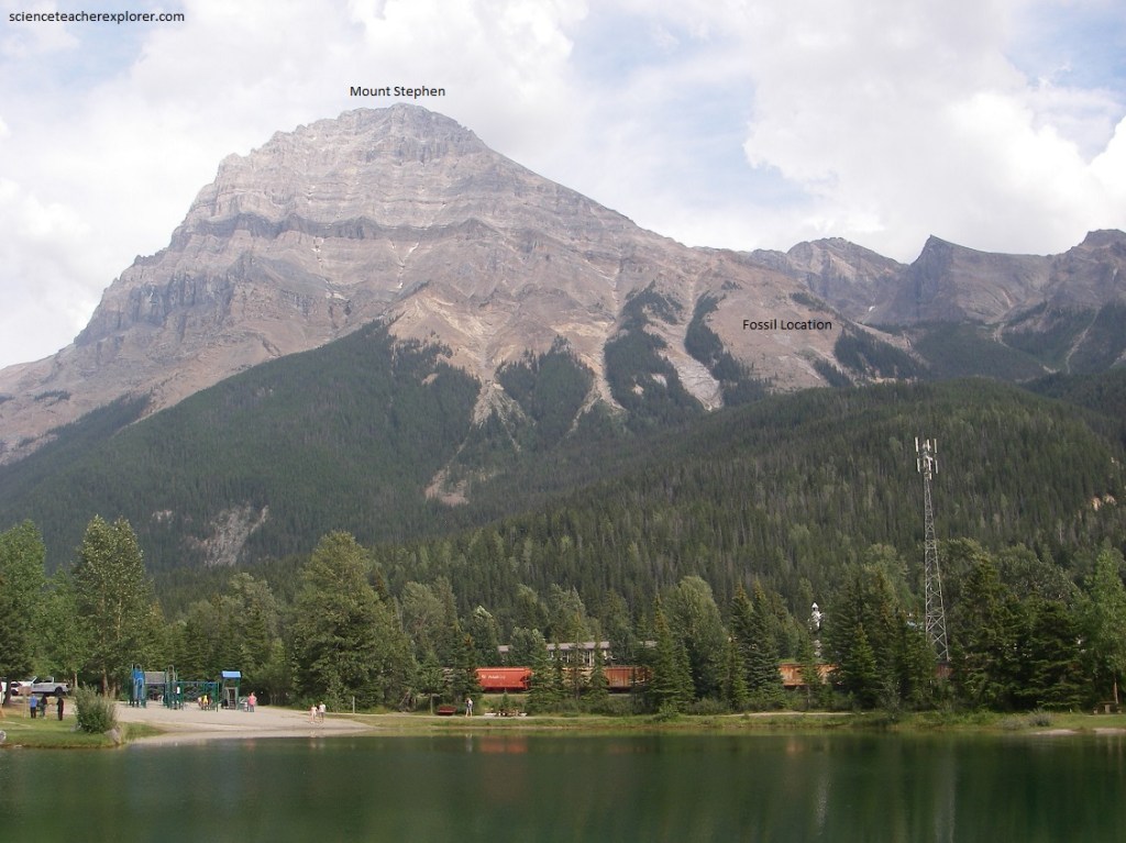
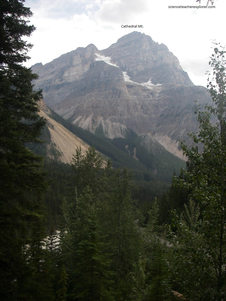
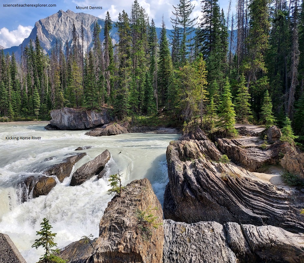
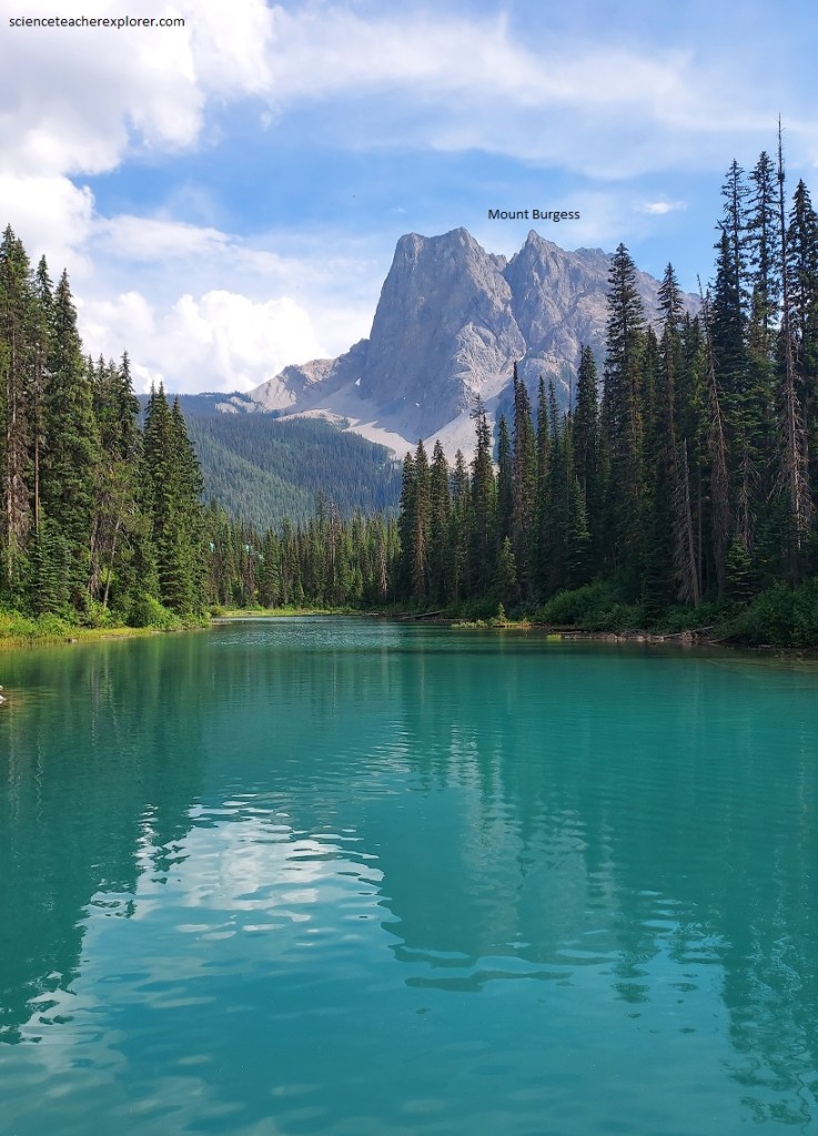
Pictured above, the whole of Mount Stephen is made of lower and middle Cambrian shales and limestone with some quartzites in the base. Pictured below, a sharp boundary separates regularly bedded and nearly flat lying beds which make up most of Mount Stephen’s mass, (including its top), form a zone of rocks of more complicated structure to the south.
Pictured above, a large fault zone, traceable for more than 30 km, passes through southeast side of the Mount Stephen and can be clearly seen in the folded and faulted zone between Mount Stephen and Mount Dennis.
One of the interesting side effects of this fault and its many subsidiary breaks is that a small block of strata containing many fossils was dropped down into the surrounding rocks. In this way the fossil-rich block has been protected from complete erosion. Many of the fossils found here are known as the rare Cambrian Burgess Shale.
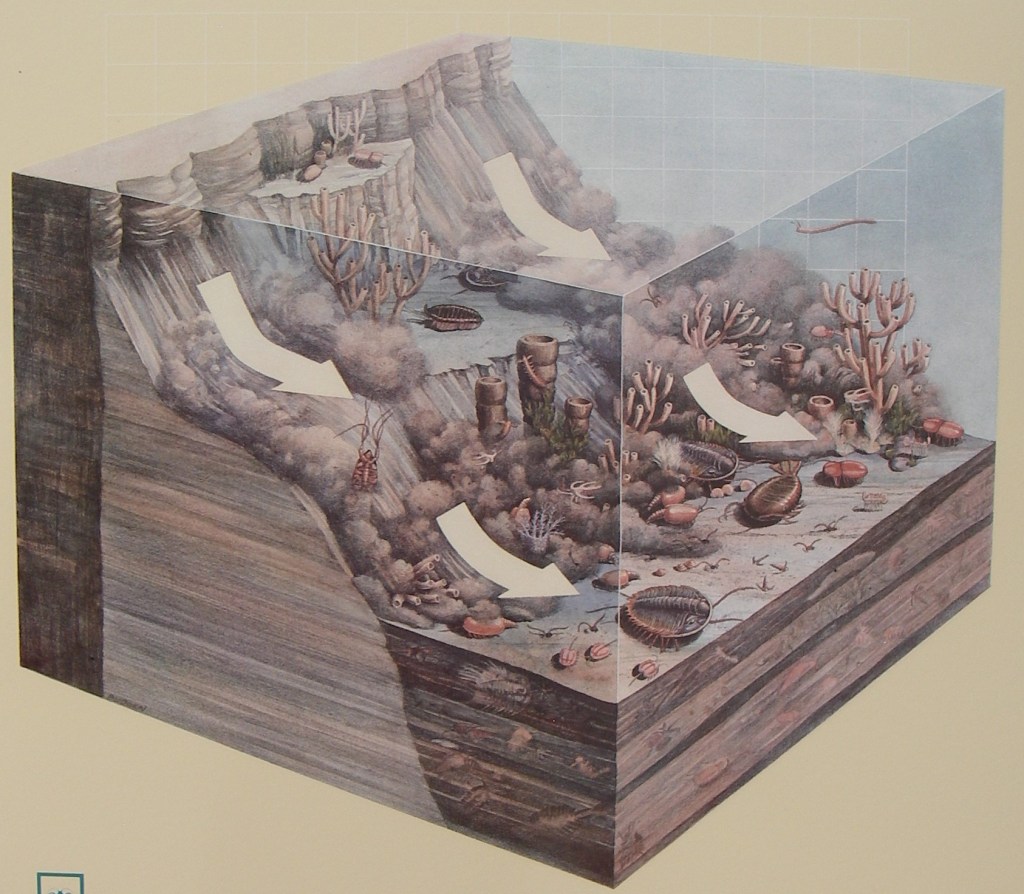
Long before the Rockies existed or dinosaurs walked the earth, sea covered this part of the continent. Strange creatures lived in these ancient water. Today their remains are found in a layer of gray sale high on the surrounding peaks. They are the best evidence we have of what life was like 530 million years ago. Pictured above, the Burgess Shale animals lived on or above the muddy sea floor. From time to time, mud that was banked up against the seaward side of the reef slumped. Caught in the turbulence, the animals would be swept away and buried, beyond the reach of scavengers, in deep water with so little oxygen that many of the fossils show almost no decay. The animals were buried at all angles, with fine silt separating each tiny fold and bristle. As more mud piled up, the bodies were flattened. Gradually, mud and silt hardened and became shale. Today, the surface of the fossil is finely detailed. In addition, scientists are able to remove micro-thin layers of rock to expose libe lying beneath. They can then reconstruct what the living creatures looked like and how they functioned.
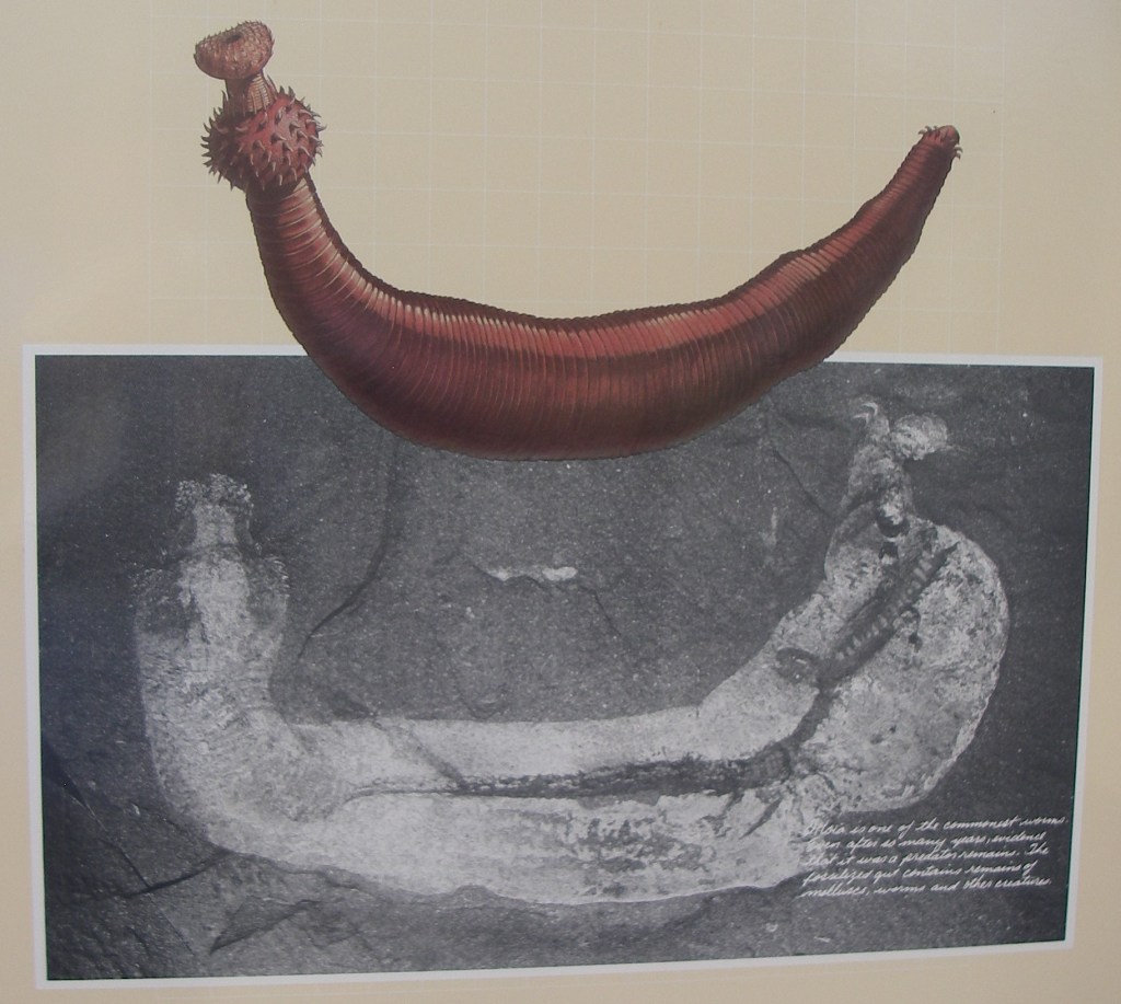
Pictured above, about a dozen different worms are found in the Burgess Shale. “Burgessochaeta and Canadia had bunches of bristles as a defence against predators. About half the species had segmented bodies, as do earthworms, bristle-worms and leeches today.
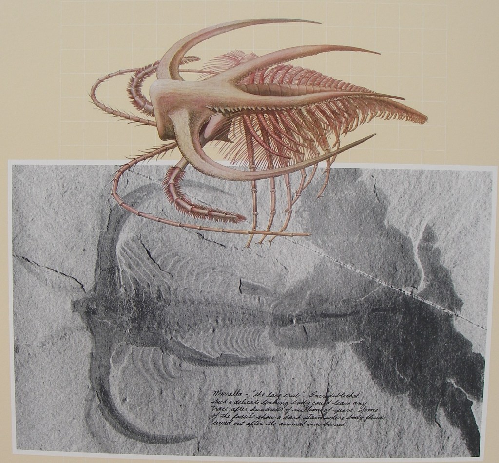
By the time of the Burgess Shale, many forms of animals with jointed limbs had evolved. With the jointed limbs came a greater variety of means of moving about and finding food. Using their limbs for propulsion, animals could crawl, swim or skim along the surface of the mud, eating algae, scavenging and preying on others. Pictured above, many trilobites, complete with limbs, are found in the Burgess Shale. Naraoia is one of three rare, soft-shelled species.
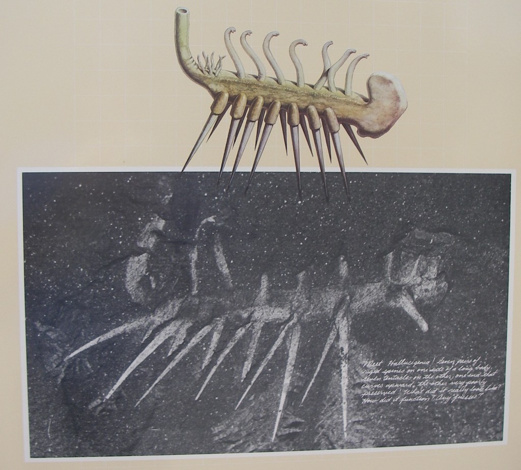
What a range of different body plans! Some of the fossils show early versions of limbs and organs that can be seen in modern-day animals. Some animals whose fossil structure we can barely understand today died out and were replaced by others better able to survive the conditions of the world. Pictured above, while Pikaia is the first creature known to reveal anything like a spinal chord or backbone, Opabinia with its five eyes, cannot by classified with any group living today.
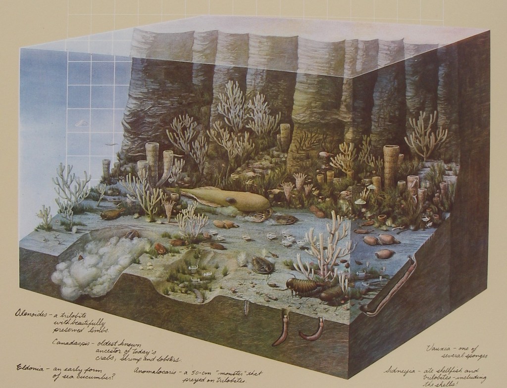
At first glance it looks like a marine community you would find today. Burrowers, crawlers and swimmers, scavenger, predators and creatures that filtered the water for food particles were all present. Even the proportion of soft-bodied to hard-shelled creatures was about the same a it is today.
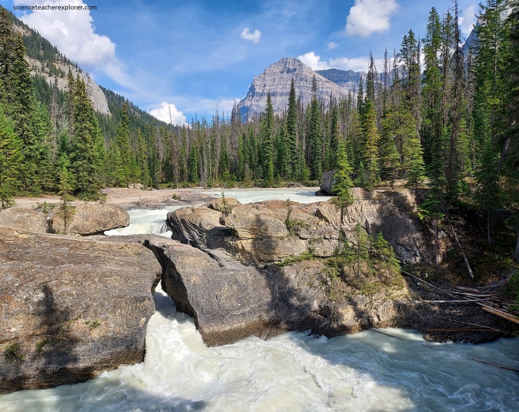
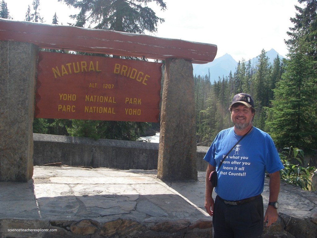
Becky and I continued southwest, down the Canadian Highway #1 for 2 km where there is a road that branches towards the west, then northward to Emerald Lake. Along this road, about 1.6 km from the junction, a turnoff to a parking lot leads to Kicking Horse River and the Natural Bridge. Here, the melting glaciers in the headwaters provide lots of silt-laden waters to Kicking Horse River. Pictured above, just above the bridge the river begins to flow faster, then it plunges through a narrow defile and under an overhanging section of the rock. All the waters of Kicking Horse River pour through this small hole.
Pictured above, the rocks at “The Natural Bridge” have had a very complicated and rugged history, beginning with their deposition as limy sediments in Cambrian seas of nearly 500 million years ago. After they had solidified into rock they were heavily folded by various earth pressures. A sheety breaking in the rocks suggests further that they were sheared at a still later date. They were then broken by jointing, more or less across the general trend of the other features.
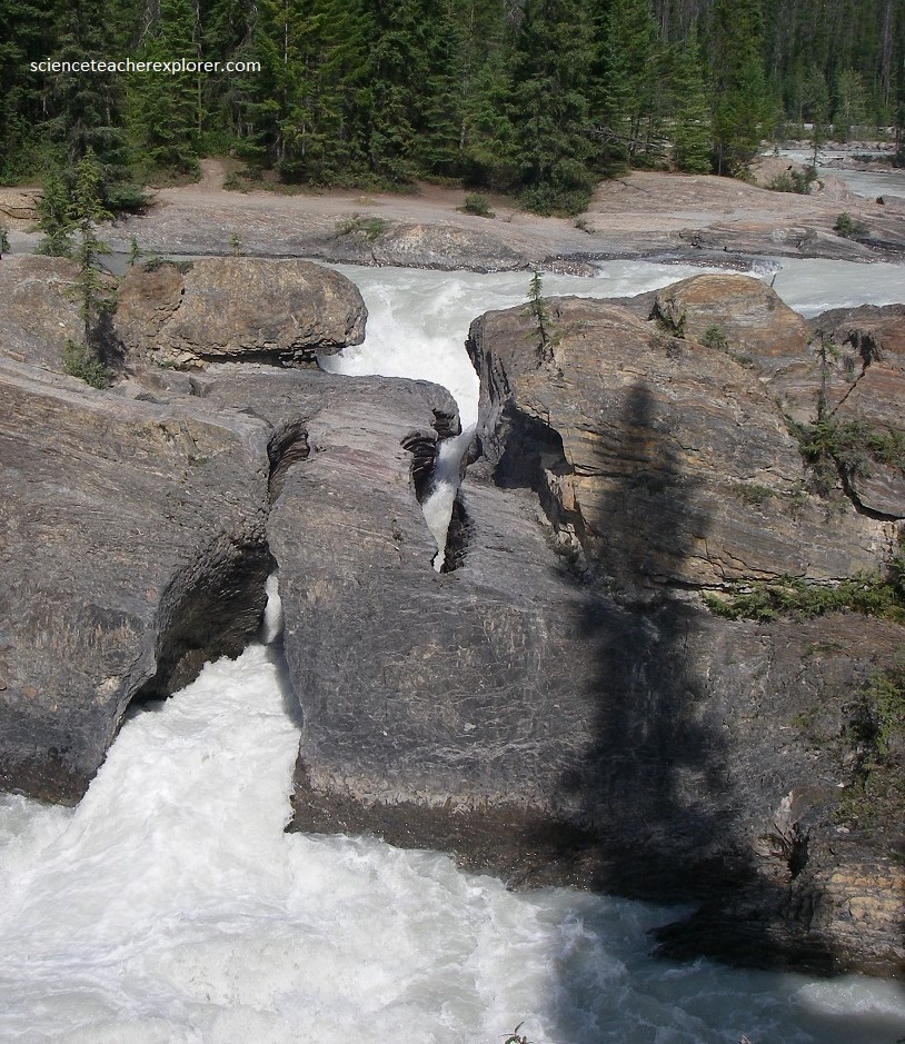
Pictured above, these rocks wee uncovered in fairly recent geological times when, following glaciation of the area, Kicking Horse River began to cut down into the valley again at this particular spot. Some of the massive limestone layers formed a barrier to the downcutting process, so that waterfalls wee produced. Water, however, leaked down into some of the openings caused by the joints and began to dissolve small quantities of limestone from the walls. One of these opening appears to have gradually enlarged until now it takes the whole volume of the Kicking Horse River. Thus the Natural Bridge has been formed where the river has cut underneath the lip of the old waterfall.
This spot in the valley of Kicking Horse River is comparatively flat, for it is built on deep glacial deposits that were dumped in this area when the glaciers were melting. For the next several miles downstream, Kicking Horse River tumbles precipitously over a rocky bed.
Pictured above, about 7 km down the road, Emerald Lake is one of the very beautiful gems found here and there along the length of the Rocky Mountain System. This very beautiful spot is the result of glacial damming of a bowl-shaped depression now filled with water. To the southeast is the jagged mass of Mount Burgess, with long scree slopes marking where the waste of many hundreds of years has accumulated at the foot of the cliffs. The color of the water of Emerald Lake, (and other glacier water lakes like it), is due to the very finely divided sedimentary materials suspended it it. As the glaciers melt, their meltwaters pick up a variety of sedimentary materials and carry it down stream. The coarsest debris, (the gravel and boulders), is left behind. The more finely divided sedimentary materials stay in the stream farther along its course and make the water cloudy and grey. After the stream empties into Emerald Lake and stands for a while, only the very finest suspended matter is left. The scattering effect which this has on the light combines with the reflection of the blue sky to give the glorious blue-green color to the water.
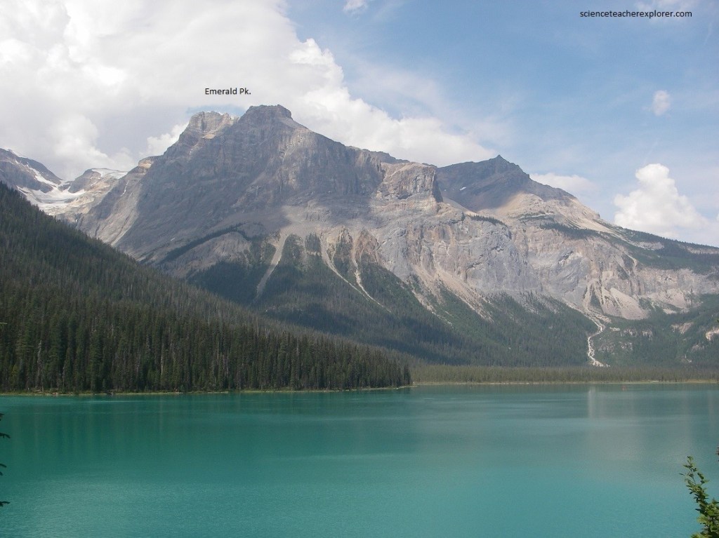
Pictured above, from Yoho Pass we see the steep-sided mountains of the President Range. The dominant peak, directly down the length of Emerald Lake, is Michael Peak. Below Michael Peak is a great bowl-shaped depression that has been carved by the glaciers. Out of this flows a small, swift-moving stream carrying a vast quantity of sand and gravel which has been built into a considerable delta on the slightly flatter valley bottom beyond the north end of Emerald Lake. To the left, Emerald Peak can be seen, (generally grey and brown structure composed of Cambrian sedimentary rocks).
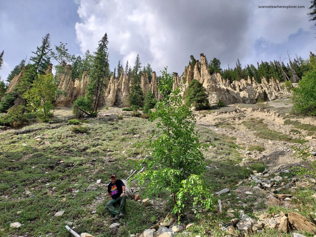
Our next stop is on the southwestern end of Yoho National Park at the famous Hoodoos of Leanchoil, (pictured above). To get to this site, we continued southeast on the Canadian Hwy #1 to for about 22 km from the Emerald Lake Road Junction. There, we turned left on a road going southeast to “Hoodoo Creek Campground”. From there, a well-marked tail lead us up to the valley of Hoodoo Creek where the Hoodoos were found standing patiently together, wearing their stone hats at different angles. The hike was about 2.5 km with an elevation gain of 400 m.
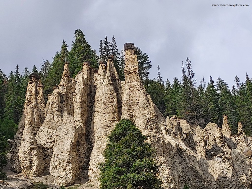
Pictured above, these unusual features have been caused by the erosion of partly consolidated or hardened glacial deposits. A great mass of sand, gravel and boulders with weak cement of limy materials has been left on the steep wall of the valley of Hoodoo Creek by the glaciers of long ago. Scattered through the mass are large boulders. Deep gullies appear, as water from above cuts deeply into the easily eroded material. The flanks of these gullies and the material generally are also susceptible to ordinary erosion by the rain and melting snow. In this particular region, which is sheltered from driving rains, the boulders protect the material beneath them from the fastest kinds of erosion. Each boulder very quickly becomes etched out of the enclosing rocks, except for the part which is best protected by the boulder, (the part directly beneath it). Thus the gravels, sands and small boulder are removed from all sides so that eventually the tall hoodoos are left.
Pictured above, walking down the Hoodoo Trail, we were impressed by the clear rushing water of Hoodoo Creek. Below this spot, the creek gradually diminishes in volume and disappears as its water soaks into the gravel flat below. It thus has no apparent junction with Kicking Horse River.
Our last stop was south around the “Big Bend”, 2 km away from the Hoodoo Creek Campground Road to the Wapta Falls Road and parking lot. From there we hike to south 2.5 km to Wapta Falls. Pictured above, at Wapta Falls the Kicking Horse River crosses a series of rocks that stand very steeply. The rocks themselves are broken and twisted but some strong resistant layers are eroded more slowly than the rocks on either side. When Kicking Horse River was cutting into its rocky bed, the soft-rock layers were quickly worn away and the hard layers began to stand up as ridges. One by one these formed barriers in the path of the rushing water.
Pictured above and below, in one place a few hundred meters downstream from the present lip of the falls a particularly resistant layer, which may still be seen sticking out of both banks of the stream, was undercut enough on the downstream side to form waterfalls. Erosion of the softer layer on the upstream side of this resistant strut was followed by a breaching of the rock wall itself, and the first falls began to change into a very steep chute. As time went on the soft-rock layers above the chute were worn away very rapidly until another resistant layer was uncovered. This in turn formed another waterfall, and during the time of its maximum development the lower strut and all traces of the lower waterfall were gradually worn away.
Pictured above, history repeated itself at the lip of the second falls as the soft-rock layers on the upper side were eroded and the resistant rock was broached. The it was cut deeply so that the water was able to flow behind and through the newly made opening rather than over the resistant rock rib itself. The remains of this rock rib is still seen just below Wapta Falls, an it is still high enough to obscure much of the view of the falls for us standing below on the right bank of the river.
Pictured above, the rushing waters continued to erode the rocks behind the second falls. As the wearing back of the lip progressed, still another resistant rock layer was uncovered. And this forms the lip of the falls as we see it today. Even now in 2022 it is undermining the resistant layer at the edge of the falls, for we can see that the lip of the waterfall is a little higher than the bottom of the stream just above it.
