Challis, ID 2006
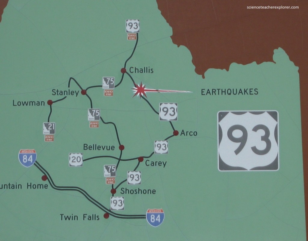
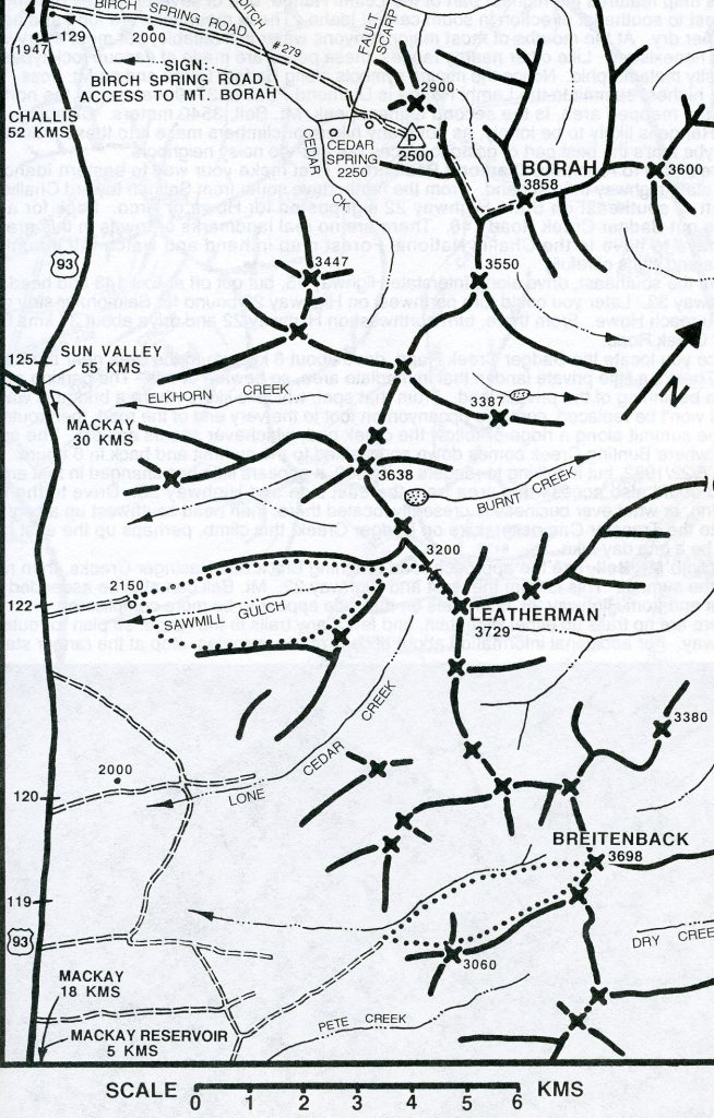
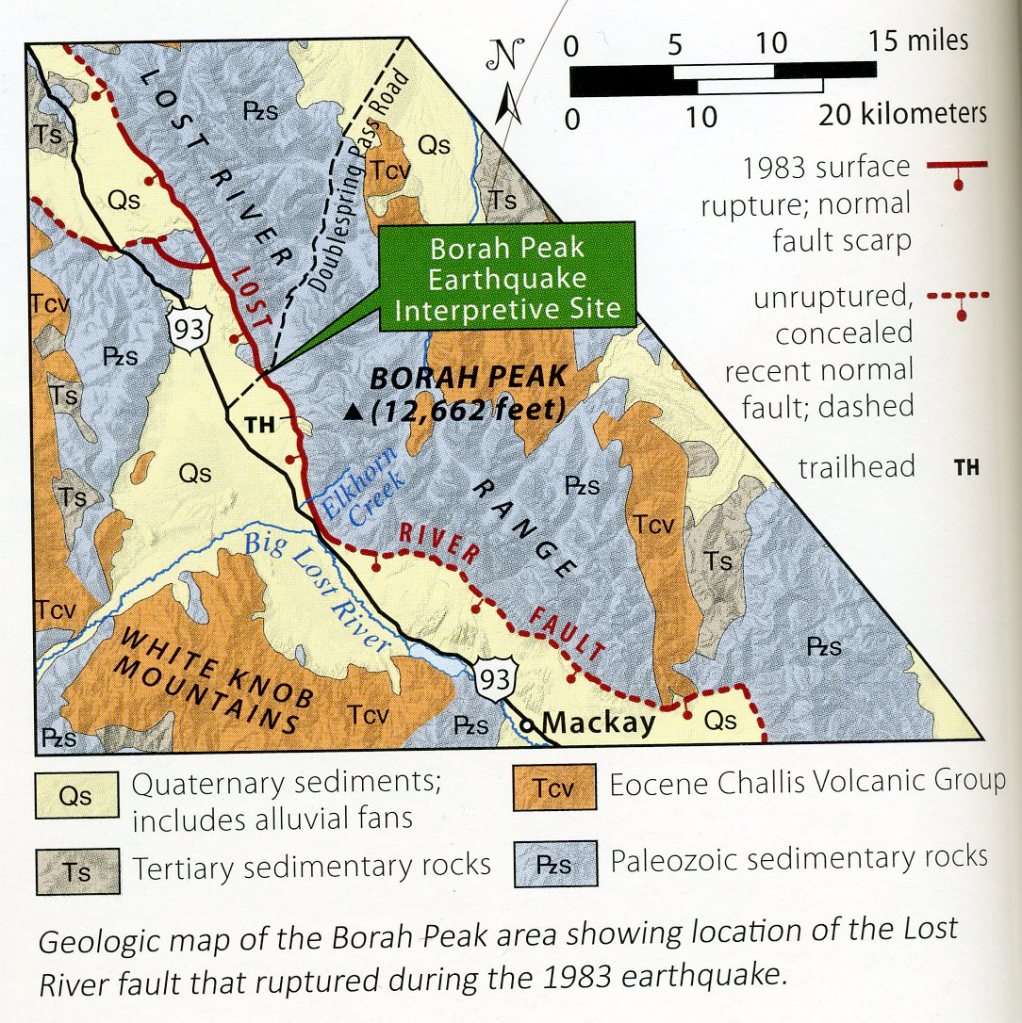
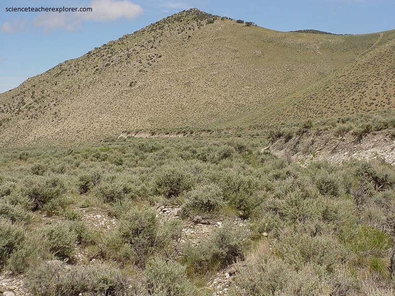
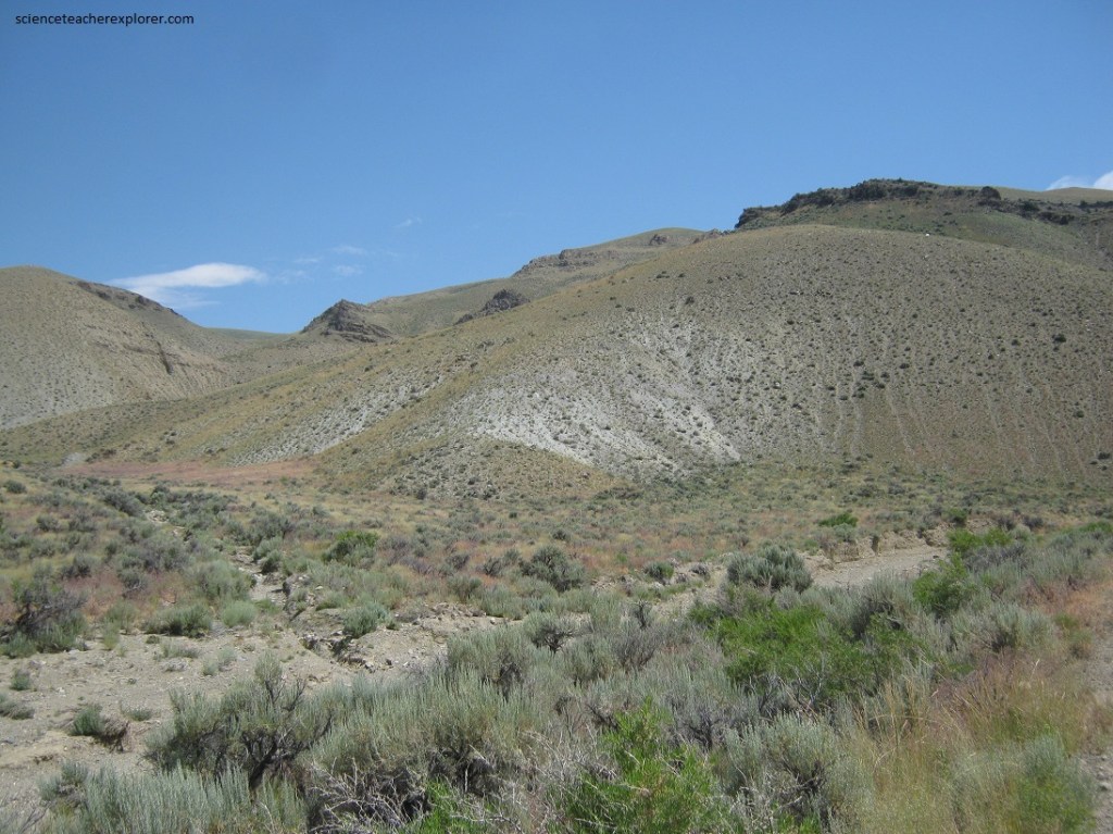
In the summer of 2006, I was contracted by NASA to organize and lead a group of science teachers from northern Utah to explore the Challis, Idaho region. There, we were going to meet up with other science teachers from the other locations in the area and the leaders of the Shoshone-Bannock Tribe. Additionally, I was required to give two lectures at the Challis Hot-Springs RV-park to the participants about: “Archeoastronomy of the Native Americans at Utah’s Parowan Gap” and “Geology of the Challis, Idaho Region”. Later, I helped lead the participants to some of the local scientific sites in the area. Our first site was to the “Big Lost River Valley” 50 km southeast of Challis on US 93. US 93 bisects the “Lost River Valley”, site of the 1983 Borah Peak earthquake, (pictured below). From US 93 we took the graded, unimproved Doublespring Pass Road for 4 km to the parking lot for the new interpretive site built by US Forest Service.
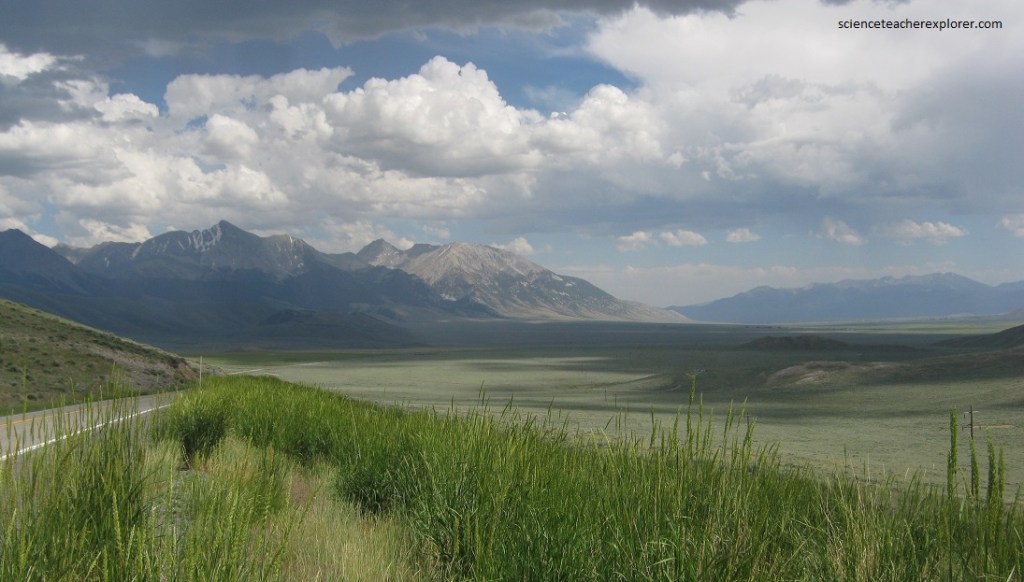
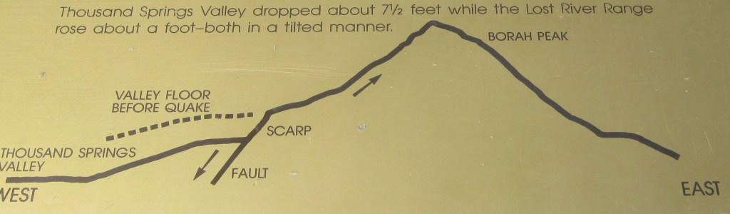
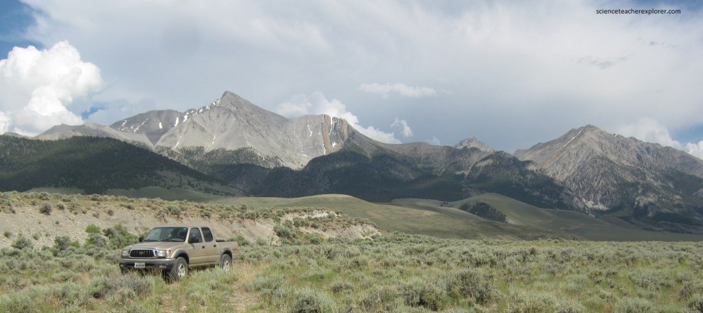
Pictured below, as the tallest peak in Idaho at an elevation of 4,085 meters, Borah Peak rises high above the other giants of the “Lost River Range”. The normal tranquility of the Valley was shattered however, on October 28, 1983, at 8:06 A.M., by a magnitude 7.2 earthquake felt over 650,000 square kilometers, the largest in Idaho’s recorded history.
The nearby towns of Mackay and Challis experienced the brunt of the intense ground motion, but shaking was felt as far south as Salt Lake City and as far north as the Canadian border. Thousands of aftershocks rattled the area in the months following the quake.
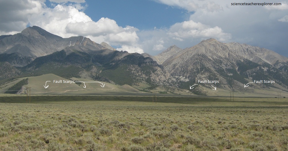
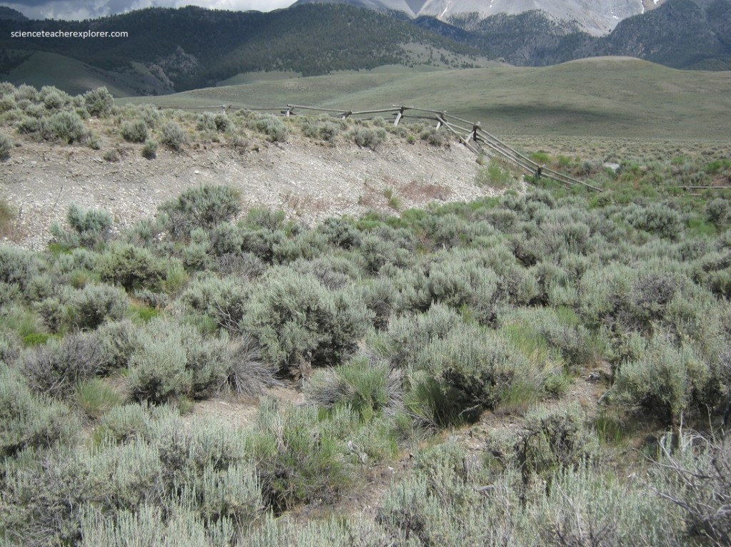
Pictured below, surface rupture cracks extended for 34 km along the west side of the Lost River Range as Borah Peak rose about 20 cm and the valley floor dropped almost 1.3 meters. Local intensity was so severe that visible waves rippled through unconsolidated sediment near the foot of the mountain. You can see the fault scarp at the Earthquake Interpretive Site along Doublespring Pass Road northeast of Dickey 4 km east of US 93.
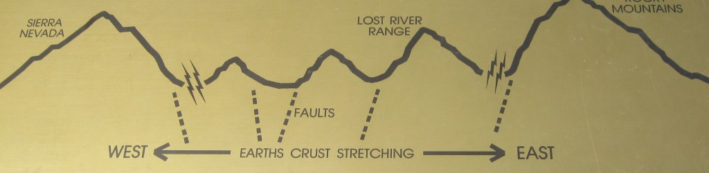
The Lost River Range is a remarkably linear feature on an enormous scale, just like its neighbors to the east, the Lemhi Range and Beaverhead Mountains. Much of the interior of the American West lies in a geologic region know as the Basin and Range, defined by its topographic expression of alternating valleys (basins) and mountains (ranges). This region extends from the Sierra Nevada of California east to the Wasatch Range of Utah and from northwestern Mexico to southwestern Montana. The distinct topography of the Basin and Range is the product of a generally east-west stretching in the crust (imaged below) about 17 million years ago.
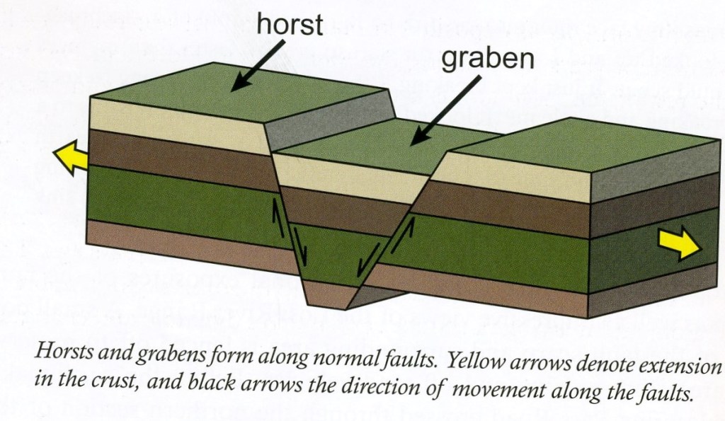
Extension in the Basin and Range is manifested by steep-dipping faults called normal faults, along which one side of the fault is raised upward while the other side slides down. The effects of Basin and Range extension are prominently expressed in east-central Idaho, where three linear ranges (the Beaverhead, Lemhi, and Lost River) cut northwestward across the state. Each of these ranges are bound on its southwestern side by a large, active normal fault and separated from adjacent ranges by wide valleys.
Cumulatively, earthquakes on the Lost River Fault have produced in impressive 2.6 km of vertical displacement, meaning that the same rock found on the top of the mountain is buried far below the valley floor.
The 1983 quake caused $12.5 million in property damage, including brick, stone, and concrete structure failures of eleven commercial buildings in Mackay and Challis. More the two hundred homes were also damaged in the area, and two children were killed in Challis while walking to school, struck by falling masonry from an old vacant building on Main Street. Strong ground shaking triggered rockfalls, landslides and other types of slope failures throughout the Lost River Valley. The rapid release of stored seismic energy in the subsurface also increased groundwater pressure, resulting in spectacular bursts of sandy water near the surface throughout the area.
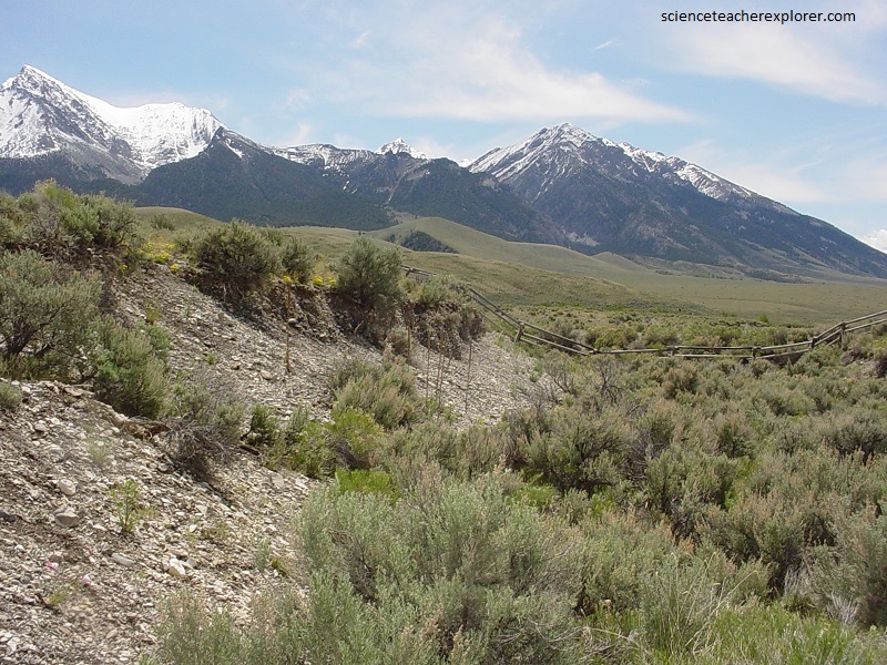
The most impressive topographic feature associated with the earthquake is the obvious scar, or fault scarp, extending across the base of the mountain. It’s a prominent feature visible even from US 93.
Pictured above and below, the height of the fault scarp varies, but at this location it is nearly 3 meters tall. A small amount of horizontal displacement also occurred, shifting the land on the eastern side of the fault slightly to the north relative to that on the western side. The fault scarp cuts and exposes alluvial deposits. Despite more than twenty to thirty years of exposure, the fault scarp has a youthful, fresh appearance due to the arid climate of east-central Idaho.
Picture above and below, the surface rupture at the Doublespring Pass Road Site is complex, with multiple fault scarps forming a broadly deformed terrain of uplifted and down-dropped blocks, called horsts (heaps) and grabens (trenches), respectively, bounded by normal faults. As the earthquake rupture approached the surface at this location, it created a network of small fault scarps rather than a single, continuous scarp.
Pictured above, the summit of Borah Peak is mainly composed of the remains of coral and other marine organisms deposited in shallow, tropical seas roughly 440 – 380 million years ago, during the Silurian and Devonian Periods, and the rest of the mountain is also composed of marine sedimentary rocks. These rocks were later folded, tilted, and thrust upward during the Sevier Orogeny, a mountain-building event that occurred from 140 – 70 million years ago. Ensuing erosion reduced these mountains to low hills until renewed faulting associated with Basin and Range extension uplifted the present mountain range about 7 million years ago. And it continues today with the 1983 earthquake.
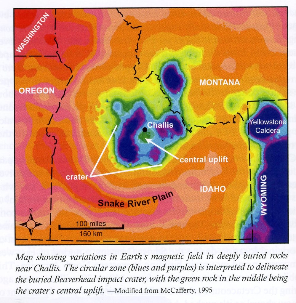
Our next scientific site was close to the Challis Hot-spring RV Park. It was a remnant geological-formation of the Beaverhead Impact Crater. Pictured above is a geophysical gravitational & magnetic-anomaly of the crater. The Beaverhead Impact Structure is one of only eight known bolide impacts with craters over 50 km in diameter. The slope behind Challis Hot Spring (in Leaton Gulch) is a conglomerate breccia that is part of the ejecta blanket.
Imaged below, the Beaverhead impact structure is the ninth largest impact site in the world, with an estimated diameter of about 160 km. The age of the impact is difficult to constrain due to the complex geology of the area and the lack of suitable material to dat, but scientists estimate the meteorite struck sometime between 900 – 800 million years ago.
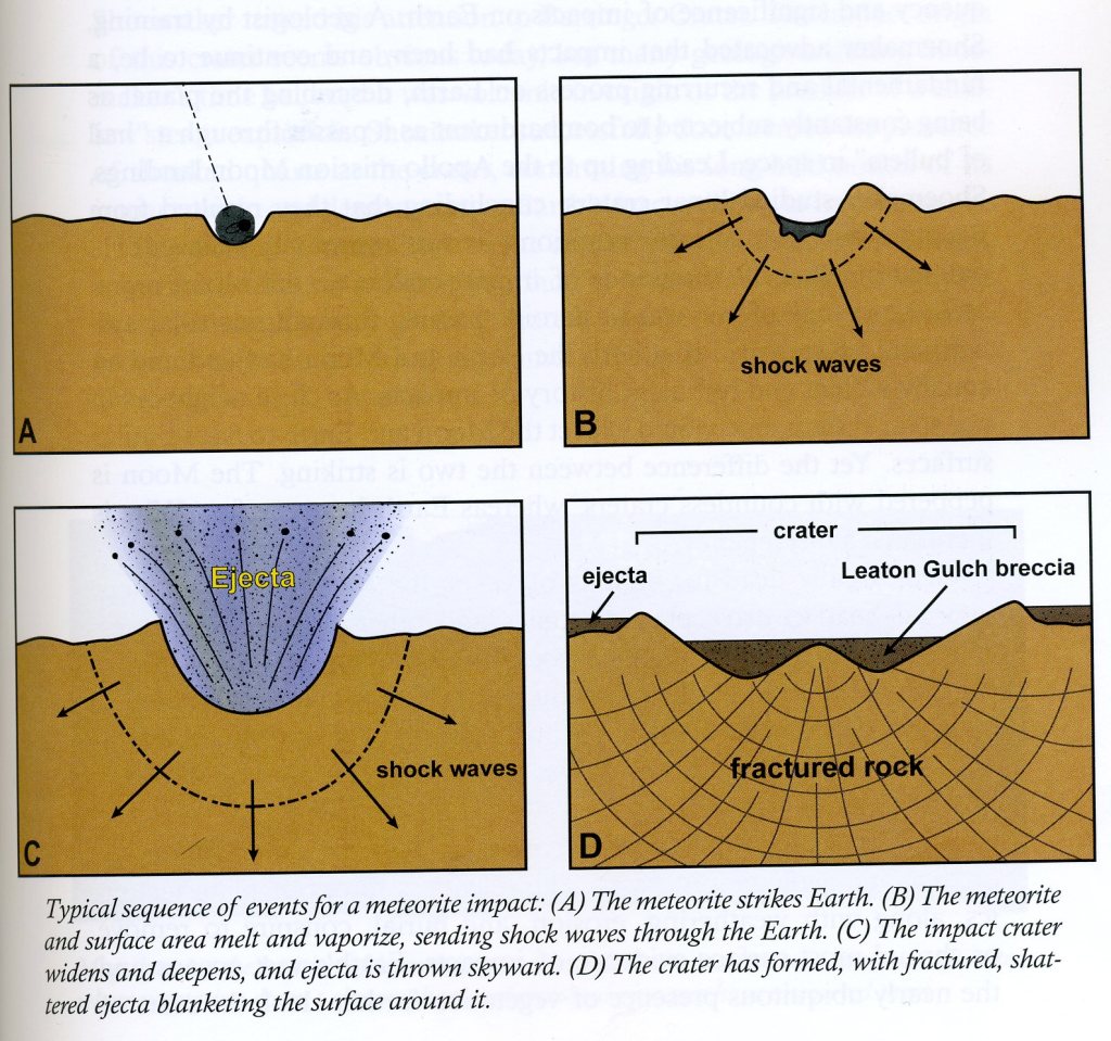
Image above, the intense pressure of an impact that is this exceptionally large, exceeds the strength of both the meteorite and rocks within the target area, causing the meteorite and much of the impact rock to vaporize or melt. Fragmented and melted rock is tossed out of the crater, blanketing the area around the crater with broken rock and debris ejecta.

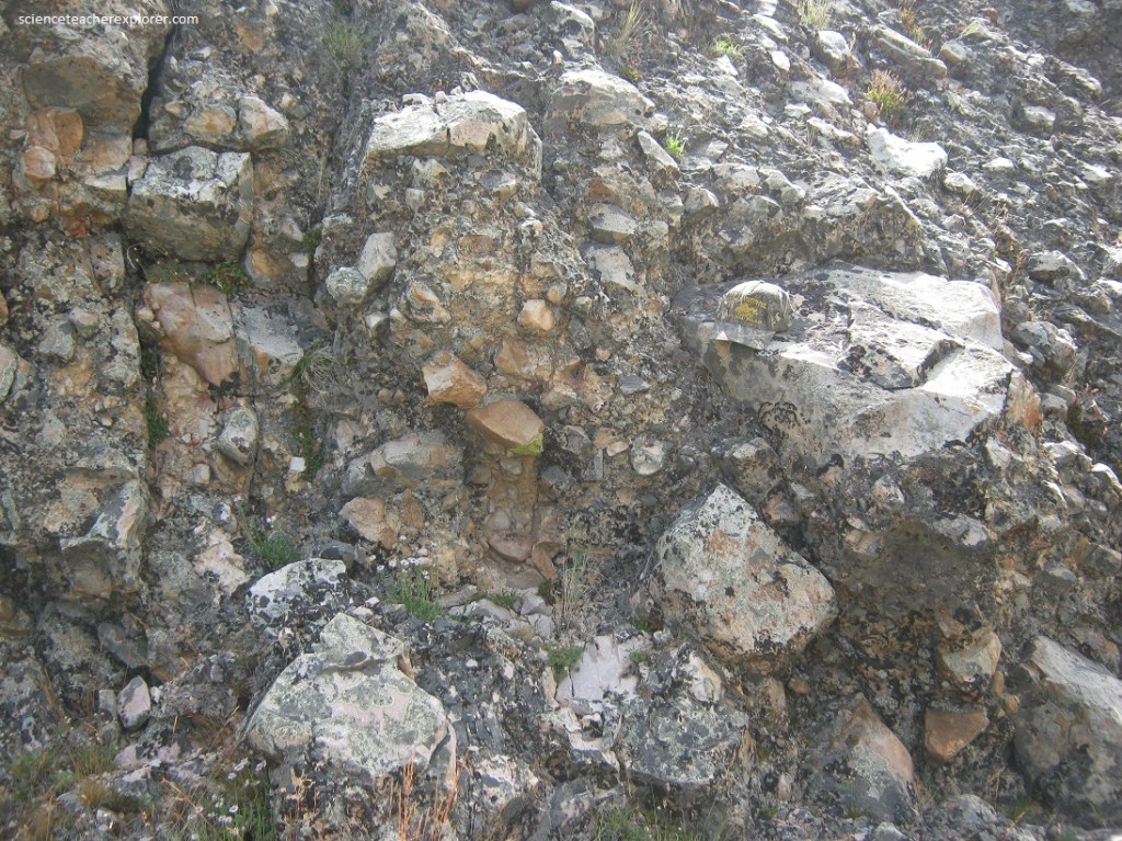
Pictured below, the brecciated Beaverhead Impact Formation consists of blocks of various shapes and sizes cemented together in a hodgepodge fashion. Most of the large particles are angular, making this rock breccia. The fragments are exclusively composed of tan to white quartzite. The angular rock fragments in the breccia are large, some exceeding 1 meter in diameter, suggesting the powerful and energetic process to form this unit.
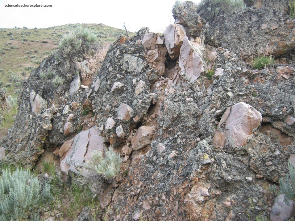
Pictured above and below, detailed microscopic analysis of quartz grains within the breccia has reveled the presence of planar deformation features, (shocked quartz). The tremendous force of a meteorite impact shocked the durable quartz grains of the rock it hit, breaking and ejecting blocks of quartzite within and just outside the impact crater. The jumbled blocks were later cemented together by silica carried by groundwater to form the breccia we see today.
A series of major geologic event that occurred after the impact complicated the geology of the area. The entire area of rock connected to this impact was transported 100 km east of its original location during the Sevier Orogeny, (a period of east-west compression and mountain building in western North America). This mobile mayhem occurred mainly from 140 – 70 million years ago, during the Cretaceous Period. Following this event, widespread volcanic eruptions inundated the region with ash, lava, and sediments about 50 million years ago, during the Eocene Epoch. Known as the Challis Volcanics these deposits stull cover and obscure many of the older rocks below them, (including the Beaverhead impact formation). A final, complicating event known as Basin and Range extension began about 17 million year ago, stretching the region in an east-west direction and creating an alternating series of uplifted mountains and down-dropped valleys bounded by faults.
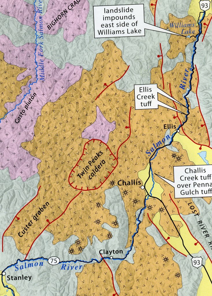
The Challis Volcanic Group is part of a broad swath of Eocene-age volcanic rock extending from Wyoming to British Columbia, only parts of which remain after millions of years of erosion. The massive eruptions began when the crust was stretched and extended during a new period of tectonic motion beginning 50 million years ago, and thousands of feet of the searing ash and debris filled existing drainages of that time. Recent rivers and streams have been cutting new valleys for tens of millions of years since, excavating out old pathways and new.
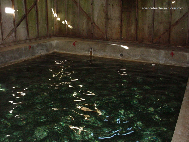
Pictured above, in an area where volcanoes exist or used to exist, water from rain and snowmelt percolates or seeps into the ground and comes into contact with a body of magma, or heated rocks surrounding the magma body. This water becomes superheated to over 390℉ (200℃). This superheated water is less dense than the cold water seeping down into the ground – and thus lighter – so it is forced back to the surface through tiny cracks and normal faults in the surrounding rocks. At the surface this superheated water forms geysers and boiling hot springs like the Challis Hot Springs RV resort.
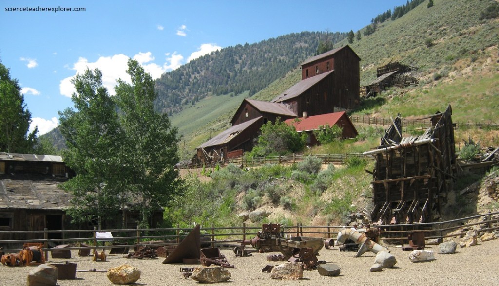
During the basin-and-range extensional period after about 17 million year ago, the stretching and thinning it created of the North American Plate created a zone of faults near the surface known as the Trans-Challis Fault Zone, (named for the nearby town of Challis). These northeast-trending faults and fractures provided pathways for magma and hot, metal-rich fluids to ascend. As the fluids rose, they precipitated ore deposits of base and precious metals, such as gold, silver, zinc, and copper. Rocks within this fault zone have been, and continue to be, a major target of mining activities like the Ramshorn Mine, 15 km south west of Challis, Idaho.

Pictured above, in 1877, a major lead-silver vein was discovered at the Ramshorn Mine. By 1878, a considerable rush to the area had begun. By the early 1880s, the nearby town of Bayhorse had a population of about 300 and a number of permanent buildings. Mining at Bayhorse peaked in 1888. Total production for the area has been estimated at more than $10 million, including approximately 200 oz. gold, 6.3 million oz. silver, 6.6 million lb. copper, 37 million lb. lead, and 39,000 lb. zinc.
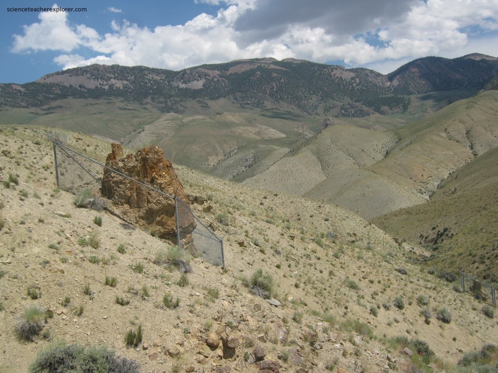
Pictured above and below, the rugged topography and arid climate of the Malm Gulch, (20 km south of Challis on SR 75), provide an excellent opportunity to study older rocks often hidden beneath the ubiquitous Challis Volcanics.
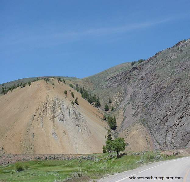
Pictured above, highway SR 75 crosses a west-dipping fault, mapped as part of the Copper Basin thrust fault, at milepost 220. Light-colored, Mississippian-age shales were originally thrust over the dark, cliff-forming Ordovician Kinnikinic Quartzite. Initial motion on this fault may have been part of the Antler orogeny in Late Devonian time. The fault motion has since reversed, with reactivation as a normal fault.
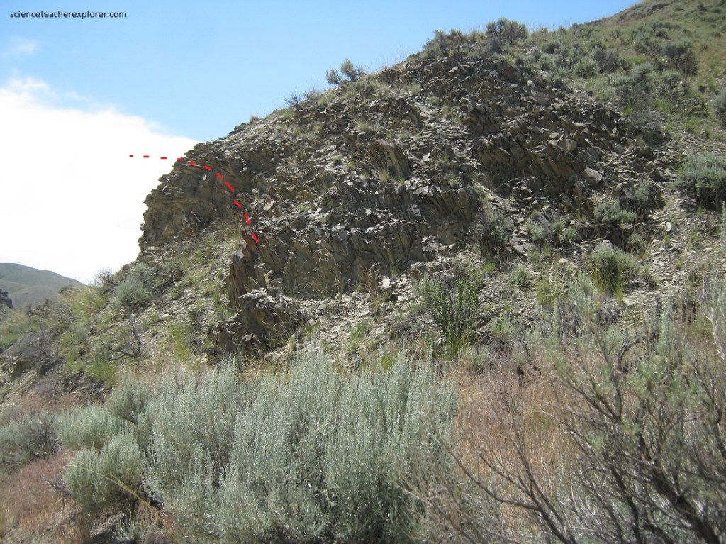
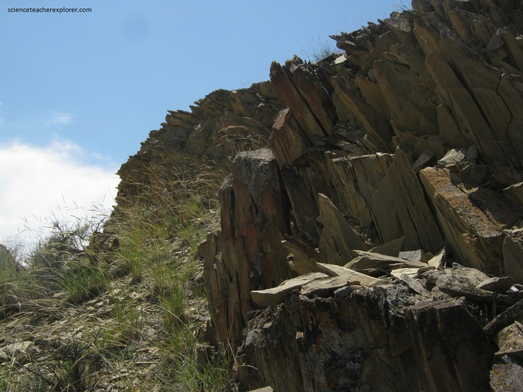
Our next scientific stop was a trail up Malm Gulch. Pictured above, was the first outcrop (0.3 km above the trailhead) of sedimentary rock adjacent to the Malm Gulch Trail. The brownish-gray rock is limestone that breaks easily and evenly along bedding planes. This limestone was deposited about 430 million years ago, during the Silurian Period, when Idaho and much of the western United States was submerged beneath a shallow, tropical sea. Near the base of the outcrop , the layers are steeply tilted down toward the west. However, they become less steep and are nearly horizontal at the top of the outcrop. The change in the tilt of rock layers over a relatively short distance is the definition of a fold.
Pictured above, the folded limestones here, are the result of the Sevier Orogeny, a regional mountain-building event caused by east-west compression across much of western North America between 140 – 70 million years ago.
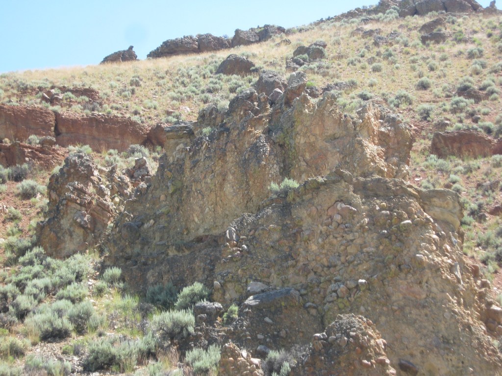
Further up the Malm Gulch trail and pictured above on the left, capping the tilted limestone is a conglomerate that consists of cemented gravel with large, rounded cobbles. The shape of the gravel and cobbles suggests moving water was the main mechanism of transport, and the size of the cobbles indicates that the energy of the water was strong and fast. The conglomerate bed lies at the base of the Challis Volcanics and represents the landscape that existed prior to the eruptions, a rugged one with steep, fast-moving rivers.
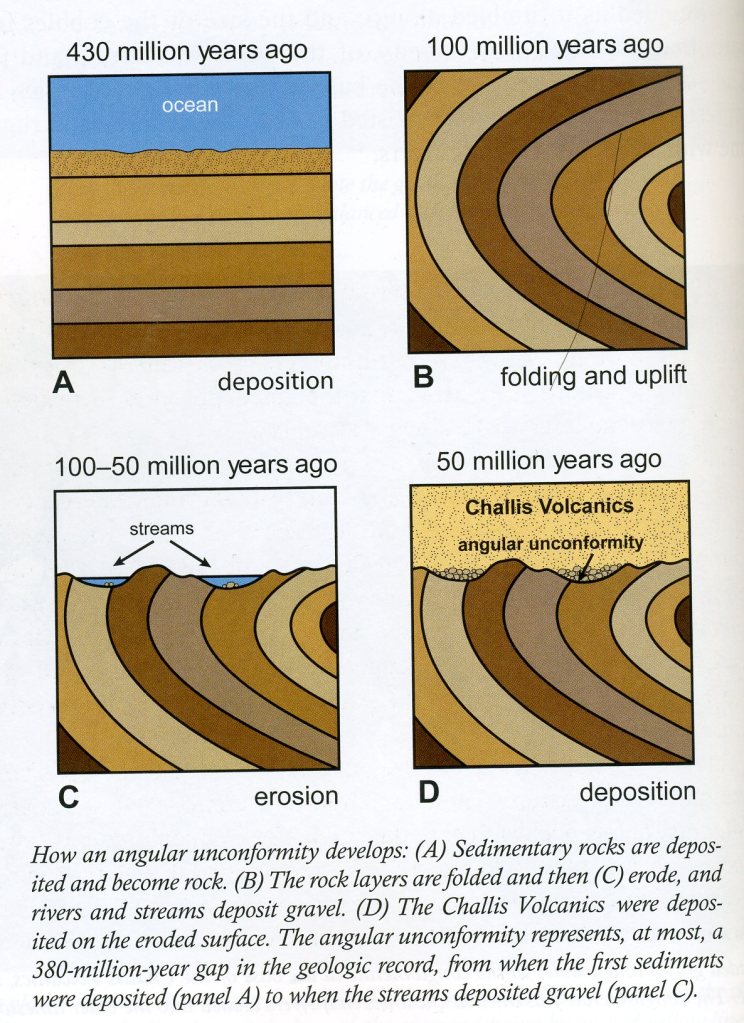
Imaged above, the tilted beds of Silurian-age limestone lying beneath nearly horizontal layers of Eocene-age conglomerates create a unique contact known as an angular unconformity where 380 million years are missing. However, ensuing eruptions of ash and other volcanic material deposited directly atop the conglomerated completed another unconformity. Some of the Eocene valleys of conglomerate were filled with as much as 1200 meters of volcanic material.
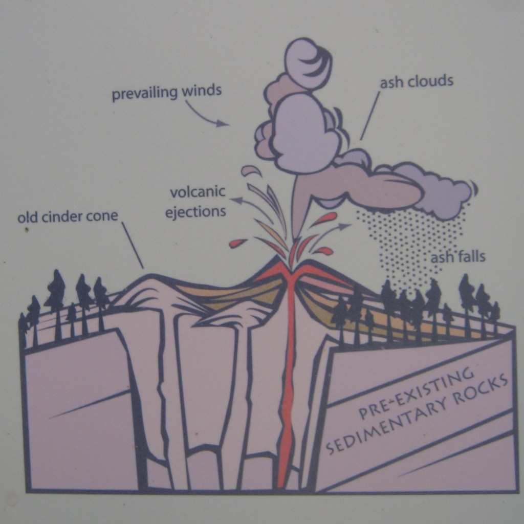
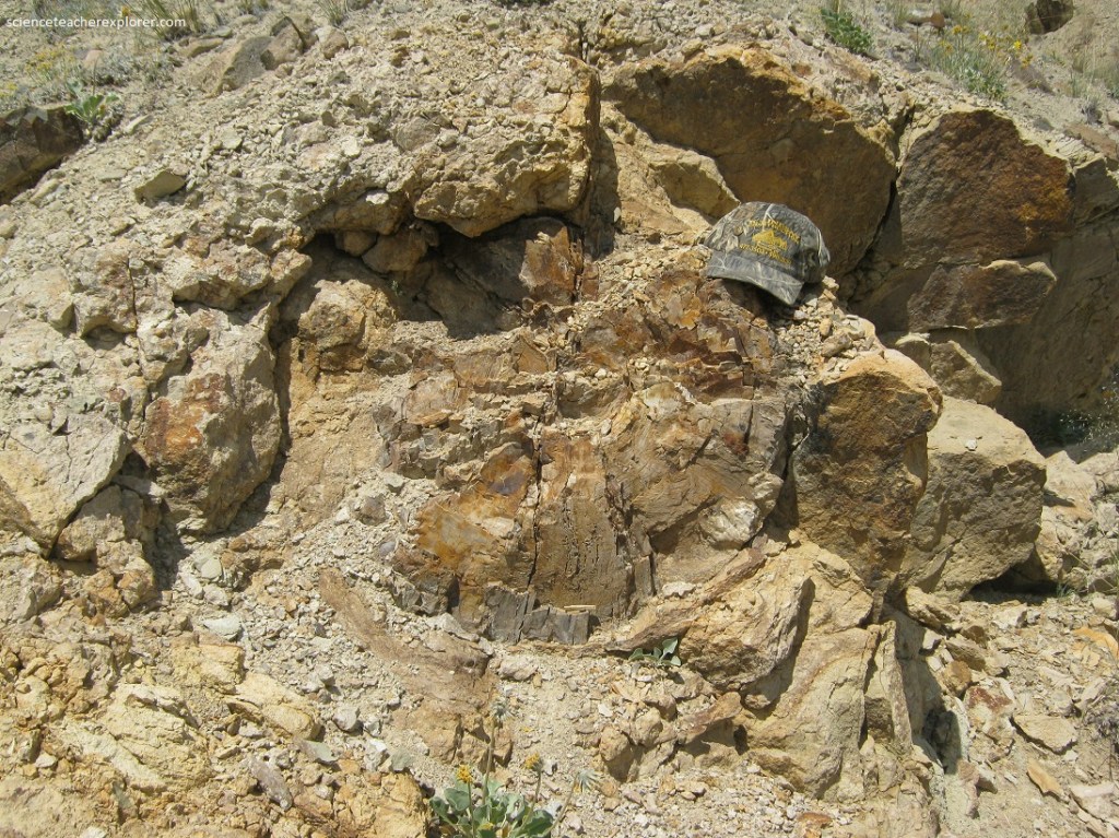
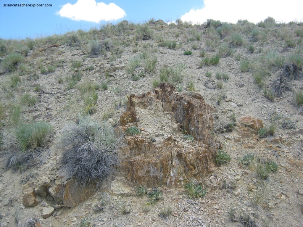
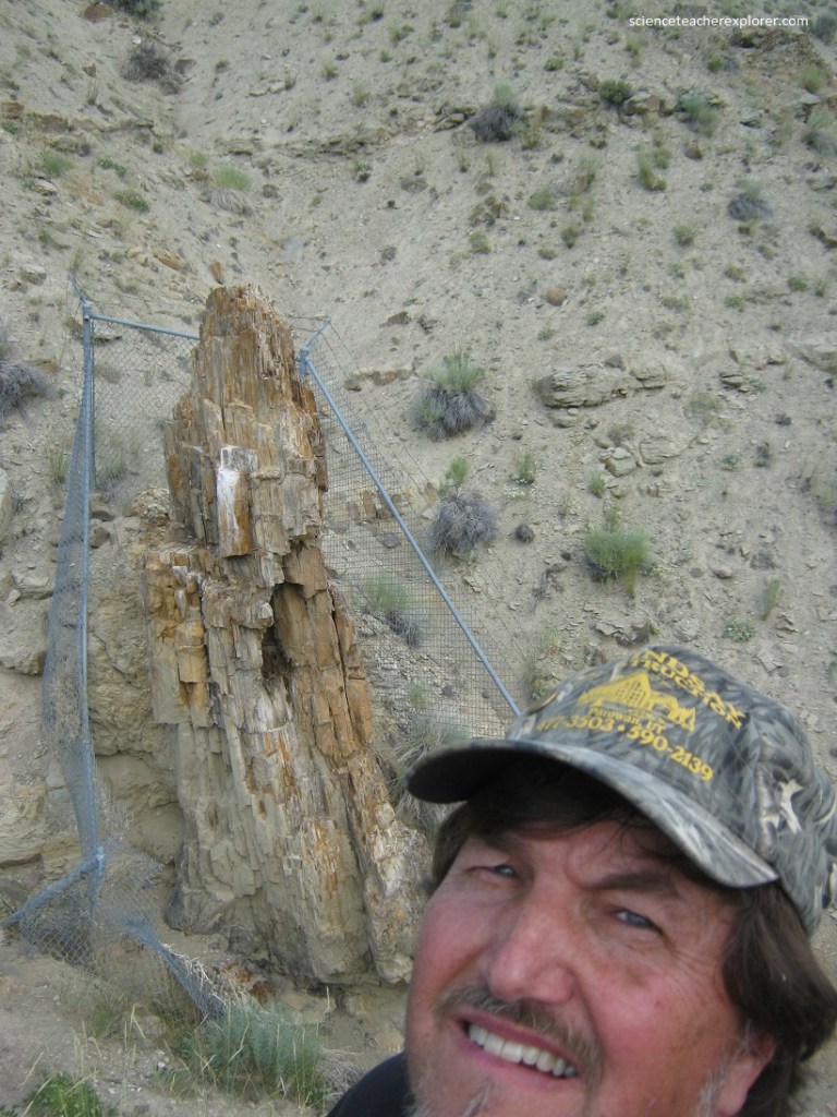
The main attraction in Malm Gulch is found 1.6 km from the trailhead. Interpretive signs directed us toward a group of petrified tree-stumps, (always leading onto the right-hand fork at intersections). The stumps at Malm Gulch are the fossilized remains of sequoia trees from the Eocene. These gargantuan trees are the tallest in the world, rising well over 100 meters, with trunk circumferences exceeding 8 meters. Organisms such as these can be considered “living fossils,” as their fossil record extends back to the Cretaceous Period, about 125 million years ago. The sequoia trees were probably formed by the product of lahars, (slurries of water, ash, rock, and debris traveling down valleys at speeds up to 64 km/hr.
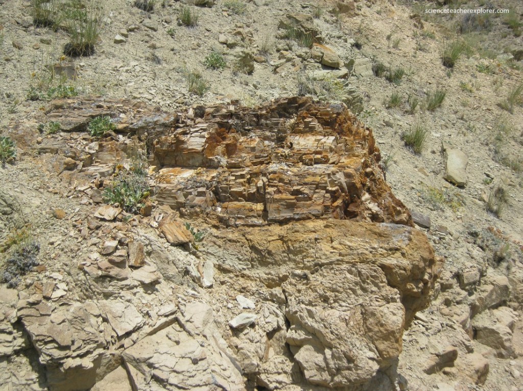
Pictured above, Malm Gulch passes through alternating sequences of coarse lahar deposits and fine volcanic ash. The massive tree stumps are obviously found on the hillside to the north of the Gulch. Fencing has been emplaced around some to protect them from collectors, but still allows for observation. The hillside also contains dozens of unfenced stumps as well as horizontal logs.
Pictured above and below, the sequoia stumps and logs are scattered across the hillside at various elevations, suggesting a succession of forests grew here over time. Scientist have documented at least six discrete forests embedded in about 52 meters of volcanic material on the hillside. Sufficient time elapsed between the deadly events to allow soils to develp and trees to regrow to maturity.
Pictured above and below, these sequoias were killed in an energetic environment, and what did them in also allowed for their preservation. Explosive eruptions from nearby calderas rained thick deposits of hot ash onto the trees, charring and burning much of their exposed surfaces and spelling certain death. However, with their increased moisture content, girth, and connection with the root system below, the bases of some trunks were spared this infernal death. Ash-rich lahars also buried some of the trees.
Pictured above and below, the burial created an oxygen-poor environment, staving off decomposition and setting the stage for preservation. Ash is rich in silica, the same material that composes the durable mineral quartz. Rainfall percolating down through the ash and lahar deposits dissolved some of the silica, transporting it downward into the buried tree stumps. As the silica-rich water passed through the porous wood, it saturated the wood’s cellular structure, much like a sealant, preserving the wood’s original internal structure and texture. The silica eventually crystallized to form fossilized wood.
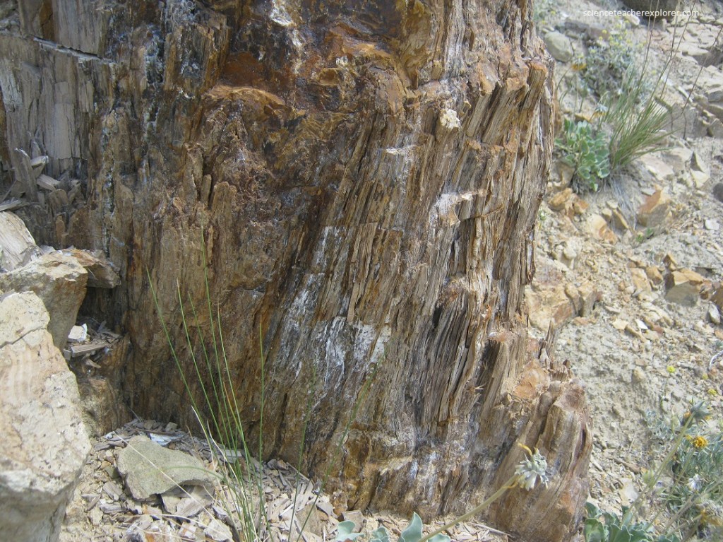
Pictured above and below, because the fossilized stumps are composed of precipitated silica and are hard, well cemented, and resistant to weathering, they protrude from the softer, grainy, more porous ash and lahar deposits.
Pictured above, the Challis Volcanics harbor the only Eocene-age plant fossils in Idaho. They provide a valuable insight into the climate of that time. This assemblage suggests that a moist, temperate climate existed in central Idaho during the Eocene. Sequoias demand a healthy supply of nearly year-round precipitation. The presence of these stout sequoia stumps amidst the sagebrush and desert environment of today presents an interesting dichotomy, allowing us to consider the transient nature of climates and landscapes.
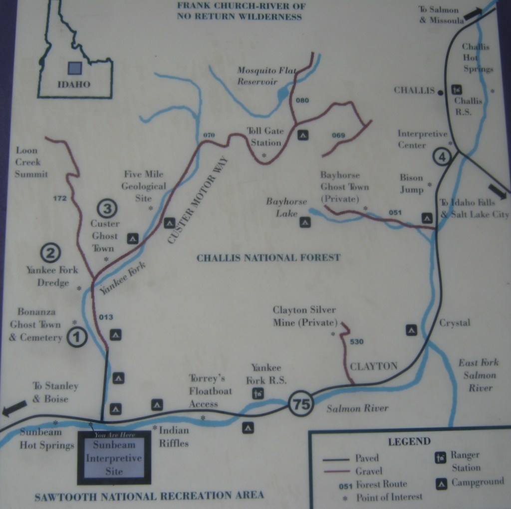
Imaged above, our next scientific site to visit was the Yankee Fork Historic Area. We visited this area by traveling along the 56 km Custer Motorway from Custer to Challis. This motorway started north from SR75 at Sunbeam, 74 km from Challis, Idaho. In 1870 the first prospectors began working claims at the junction of Jordon Creek and Yankee Fork River. The gold rush on the Yankee Fork was on and the area went through several boom period until ending permanently in 1910. During this period hundreds of people lived in the towns of Bonanza and Custer and large mills like the General Custer, Charles Dickens, Lucky Boy and Sunbeam were built to process this rich ore. Gold dredging was active on the Yankee Fork from 1940 to 1952 when an estimated 1.8 million was mined from the area.
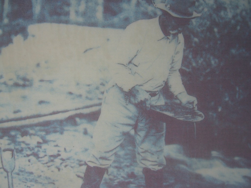
Pictured above, prospectors panned for gold in the Yankee Fork-Salmon River area from the late 1860s to 1879. Then in 1880, the Yankee Fork Consolidated Gravel Mining Company built a ditch to bring water to Sunbeam for their new hydraulic gold mining operations. Traces of their ditch were visible as we drove up Yankee Fork. In 1909, the Sunbeam Consolidated Gold Mines Company chose this same area for a hydroelectric plant to provide poser for their mine and mill 21 km away on Jordan Creek. This location was chosen because the flow rate of the main Salmon river was adequate to drive the turbines.
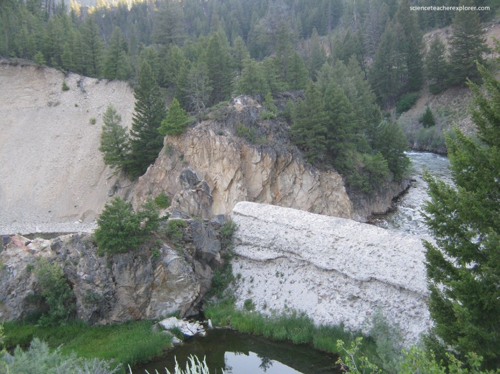
During 1909 and 1910 the young town of Sunbeam flourished as crew operated the large mine and built the Sunbeam Dam on the Salmon River to provide to the mine and it’s machinery. The construction of the dam and the power plant captured the imagination of the country when Challis’s newspaper, “The Silver Messenger”, printed postcards showing the power dam and it’s lake. Pictured above, the power plant ran only one year before the mine closed and transformed the town of Subeam into a ghost town in 1911. The dam was sabotaged in 1934 as part of the ongoing strife between those who wished to use the Salmon River water for mining or electric generation and advocates of rivers where salmon run free.
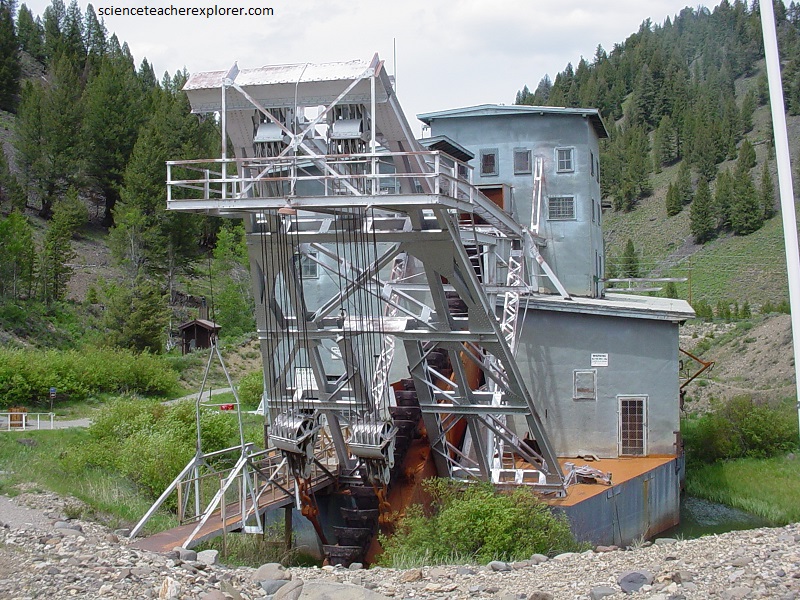
Pictured above, the historic Yankee Fork gold dredge is 13.5 km up Yankee Fork road (part of the Custer Motorway) from Sunbeam. The Yankee Fork of the Salmon river was extensively disturbed by placer mining.
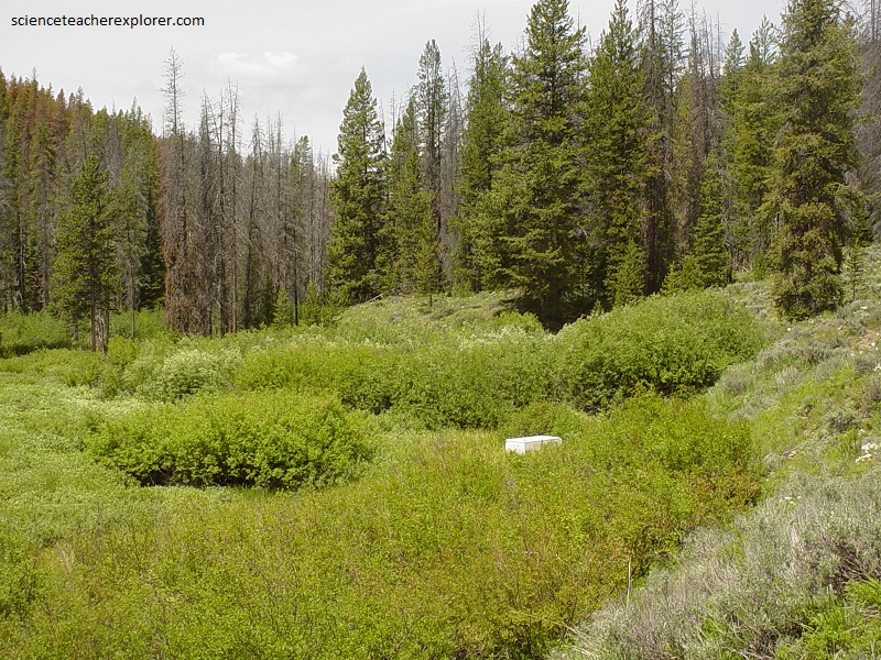
Pictured above, salmon and steelhead, (which return hundreds of kilometers to the mountains of Idaho to reproduce), are picky about where they choose to build their redds and spawn. [Redds are essentially nests in gravel where the fish deposit their eggs]. At one time, in the 19th century, Summer Chinook salmon and summer steelhead trout had found the perfect spot for their redds in Yankee Fork. However, the dam and gold mining activities prevented it to continue. So, the Shoshone‐Bannock Tribes began supplementing Chinook Salmon (Onchorynchus tschwytscha) in the Yankee Fork headwaters at the eyed‐egg stage in 2005. Chinook Salmon eggs were artificially fertilized and reared to eye‐up in‐hatchery, then planted in custom‐made in‐stream incubators (old refrigeratore) for volitional release and natural rearing.
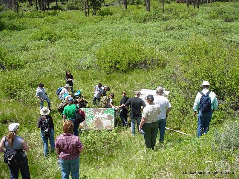
Pictured above, using NASA-GPS data from three brood years, the Shoshone‐Bannock Tribes could evaluate the efficacy of this supplementation program solely in terms of juvenile production: they could relate juvenile production to refrigerator (egg box) placement and retrieval, assess the relative contribution of refrigerator‐produced juveniles to overall juvenile abundance, and compare the performance (length, condition, dispersal distance, and survival) of refrigerator versus natural‐origin juveniles. Brood year and refrigerator-box placement within the stream (distance upstream) should be the best predictors of whether or not a refrigerator egg-box was retrieved from its original location. Meanwhile, the condition of the refrigerator-box (i.e., intact, damaged, missing) should be the best single predictor of juvenile production. [This was the main reason NASA had arranged this tour. They were evaluating the possibility of a money-grant].
Pictured above, was our next scientific spot, Sunbeam Hot Springs. Alexander Ross and his Hudsons Bay Company fur trappers were the first white men to visit these hot springs. His diary describes camping “at the boiling fountain” when they came here in 1824. In this type of hot spring, water from rain and snowmelt percolate into the ground, and are slowly heated as they go deeper into the earth’s crust. The temperature of the water increases due to pressure of the surrounding rock layers. A pressure cooker is another great example of how heat increases with pressure. This water heats up at a rate of about 2℉ (1℃) for every 33 meters it goes down; going as deep as 3,300 meters. That means the water can heat up to over 200℉ (93℃), around the boiling temperature for water. Once the water is heated it becomes less dense than the surrounding waters and finds its way back to the surface through small crack in the rocks or a fault.
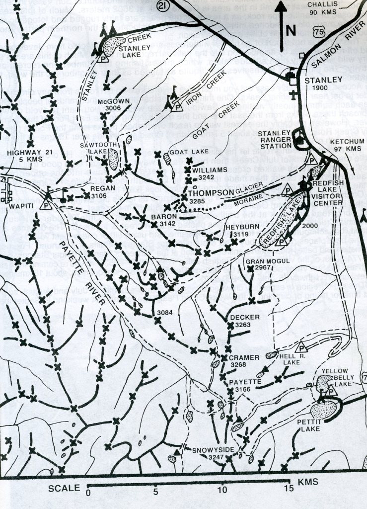
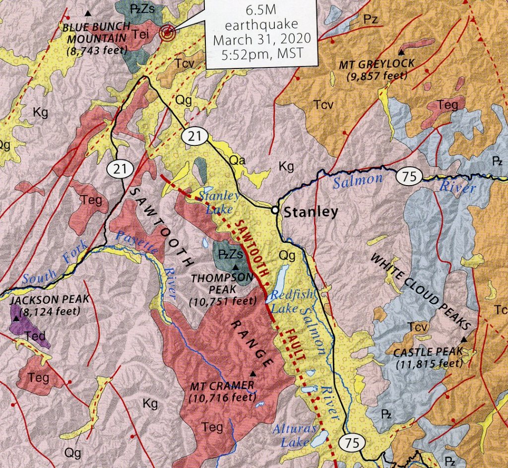
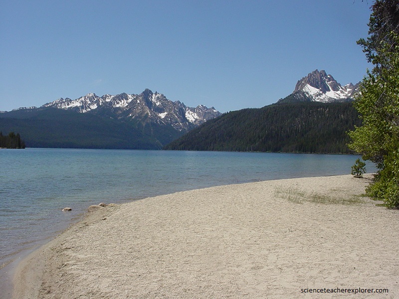
Imaged above, the Sawtooth Range abruptly juts up over 1,300 meters from the valley floor on its east side because a still-active fault zone periodically drops the valley floor down relative to the range. A prominent fault scarp has been revealed along most of the range front that is 4 – 10 meters high in 14,000 – 11,000 year old glacial landforms and 2 – 3 meters high in Holocene stream landforms, implying two to three post-glacial events ruptured recent sediments. (A recent 6.5 magnitude quake occurred in 2020).
Our next scientific spot to visit was at the foot of the Sawtooth Range. Pictured above, the central part of the Sawtooths is Eocene pink granite, part of the Challis magmatic episode roughly 50 – 45 million years ago that produced both plutonic (subsurface) igneous rocks and volcanic eruptive material. Considerable erosion since then has unroofed the plutonic rocks and stripped away much of the volcanic cover.
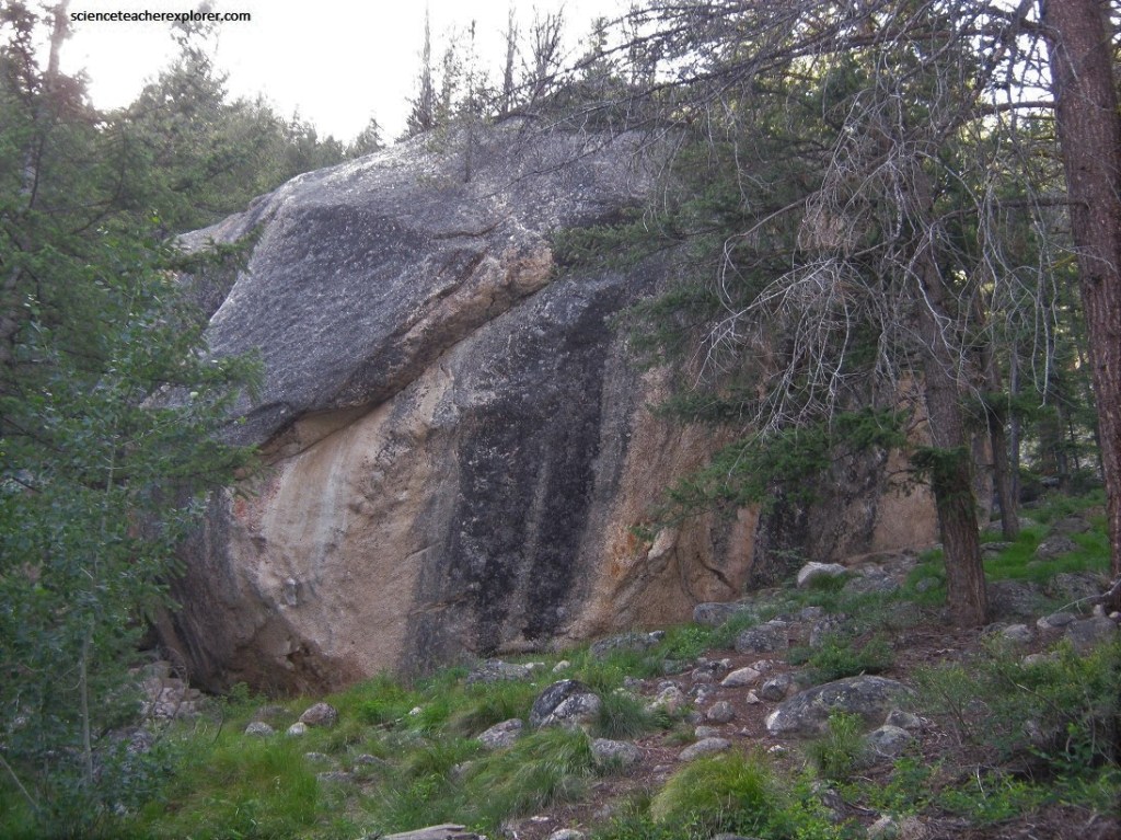
Pictured above, steep cracks (joints) formed during and after cooling are characteristic of the Eocene granite in Idaho, leading to the formation of spires and jagged ridges as slabs of rock peel off during erosion processes such as ice wedging.
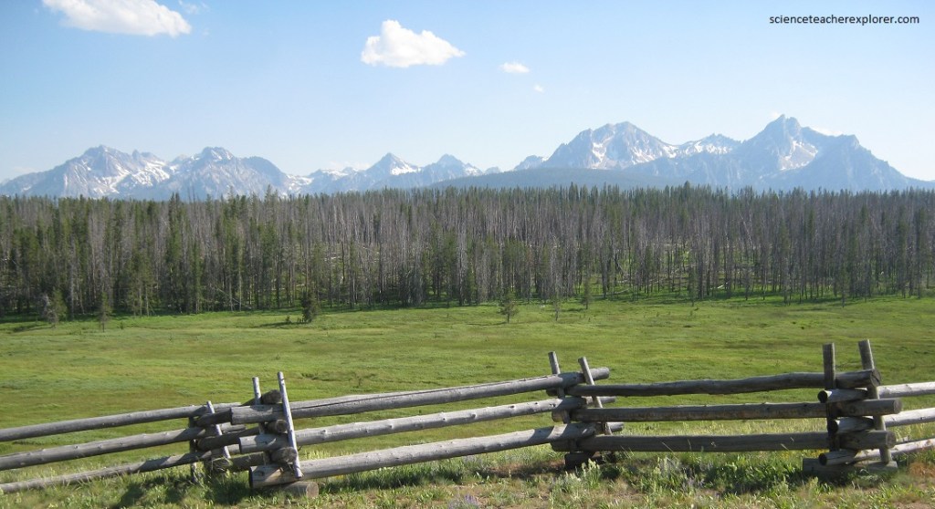
Pictured above, the elevation of the Sawtooths makes them susceptible to alpine glaciation, and the higher mountain valleys were filled to the brim with ice during the most recent glacial episode about 18,000 – 11,000 years ago. Glaciers crept out of the range onto the Sawtooth valley floor below, leaving behind exquisite lateral and terminal moraines, prominent gravel ridges, and giant erratic-boulders of glacial rubble, (pictured below).
Our last scientific stop for the conference was the Boise Basin Dike Swarm. As the South Fork of the Payette River carves a canyon west from Lowman to Garden Valley, it exposes a series of steep, tabular intrusive bodies known as dikes, (imaged below).
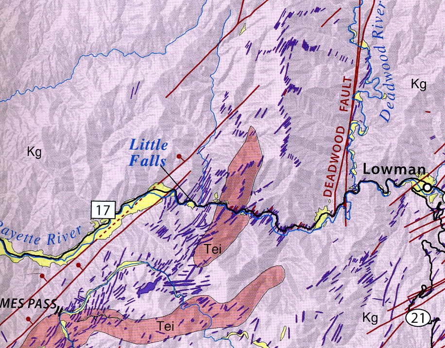
Pictured below, ranging in width from a meter to 10 meters, these igneous dikes trend southwest to northeast and can be traced down into the canyon and back up the other side like tough rock walls. Some of the larger dikes may well have once fed lava flows, but erosion since their formation about 45 million years ago has removed any evidence of an overlying volcanic pile in the area west of the main Challis deposits.

Pictured above and below, this concentration or swarm of dikes extends southwest into the Boise Basin. Part of the Challis magmatic event, the dikes cross-cut the Cretaceous Atlanta lobe of the Idaho batholith as well as Eocene intrusive rocks that pre-date the dikes.
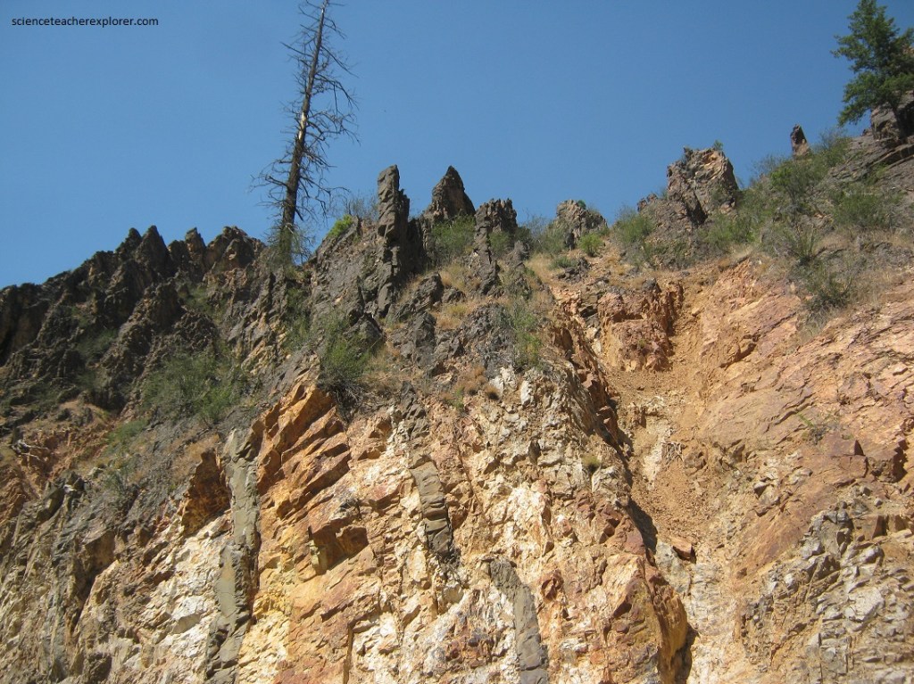
Pictured above, the dikes are formed in an extensional environment where the crust has pulled apart, here to the northwest and southwest. The basalt or dacite dikes tend to be resistant to weathering, and here, they form ribs and litter the hillsides with rock rubble known as float.
