Stonehenge, England
On August 6th, 2016; I had to opportunity to explore Stonehenge, England. Stonehenge is a monument located on the Salisbury Plain, in south- central England. The basic structure is a set of standing stones set in a circle that surrounds a horseshoe-shaped set of standing stones.
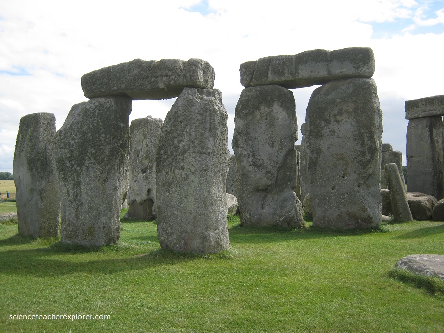
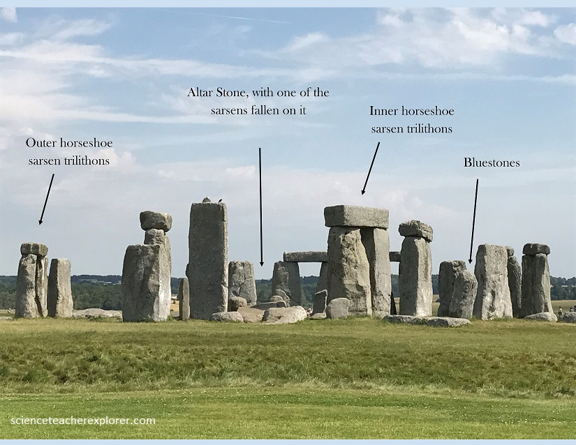
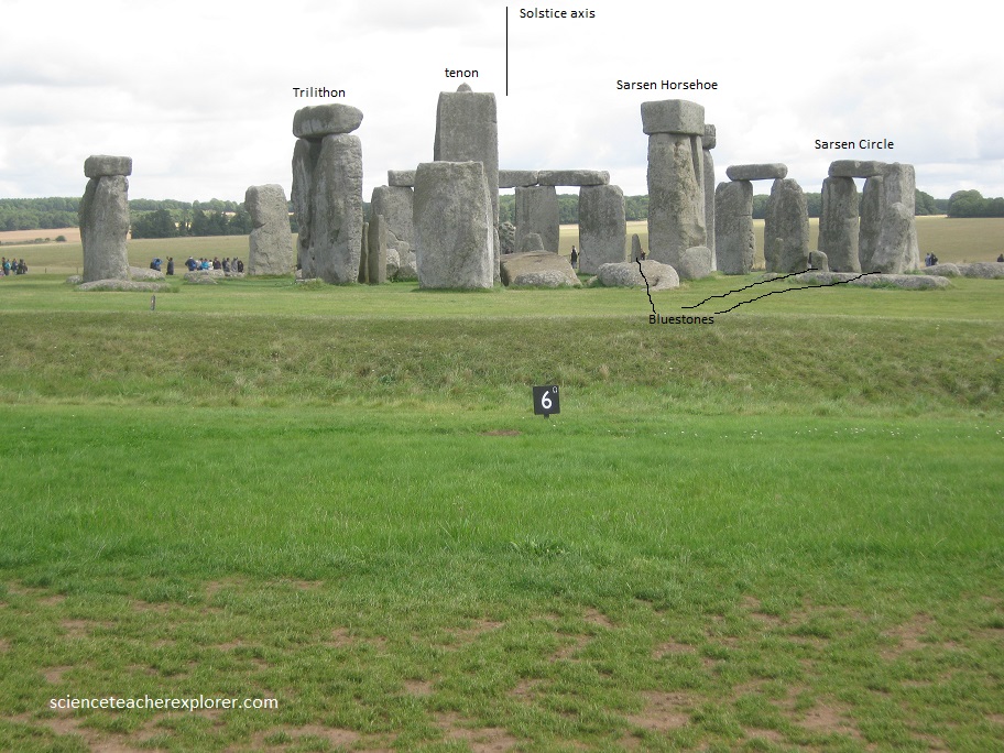
The central set of stones consists of 5 pairs of very tall stones topped by a horizontal stone, called a lintel. Each of these so-called trilithons have the lintel stone pegged to the vertical stones with a mortise-and-tenon joint, which has a knob sticking out of the top of the standing stone that fits into a hole in the lintel so that the lintel cannot easily fall off. The tallest stone reaches 8m from the ground; the biggest stones weigh 40 tons.
The horseshoe of trilithons is surrounded by a circle of stones. The basic circle originally consisted of 30 standing stones, each topped by 2 lintels to form a continuous ring running around the top. The stones in the circle are made of a sandstone rock type called sarsen.
An opening toward the northeast forms part of a long linear feature called the avenue, which is defined by 2 parallel ditches running out from the circular ditch around the monument. This avenue goes perfectly straight for 700 m before veering to the right and ultimately running down to the River Avon. At the start of the avenue, where it touches the circular ditch, is a now-fallen dressed, or cut, rock known as the Altar Stone.
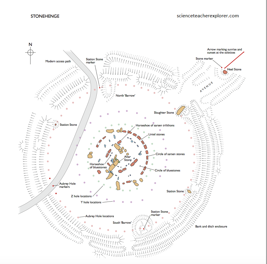
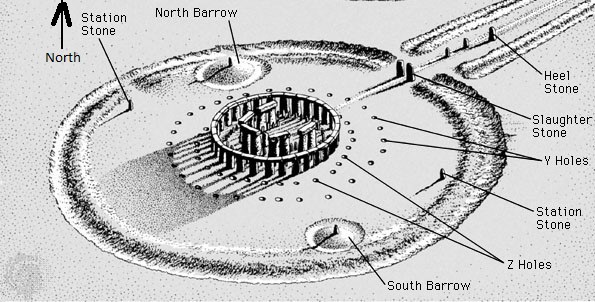
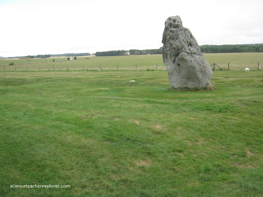
Just a bit outside the ditch, just off-center in the avenue is the upright Heel-stone, which is famous because it defines the astronomical alignment of Stonehenge; that is, on the morning of the June solstice, if you’re at the center of Stonehenge, you’ll see sunrise over the Heel-stone. There are many more stones and pits within the central ditch area, including a circular array of 56 pits called the Aubrey Holes. Nearly on top of these Aubrey Holes are 4 undressed stones that define a rectangle called Station Stones, 2 of which are surrounded by small ditches. Close around the basic stone circle are 2 more rings of holes that are irregularly spaced, and the center of the whole circle has a stone called the Altar Stone, which is now fallen and lying mostly buried under a lintel fallen from a trilithon.
Stonehenge and its surroundings were made by a culture of Neolithic farmers known as Beaker people. They flourished throughout the British Isles and western Europe from the Late Stone Age to the Early Bronze Age. Stonehenge was built in stages, from roughly 3100 B.C. to 1600 B.C.
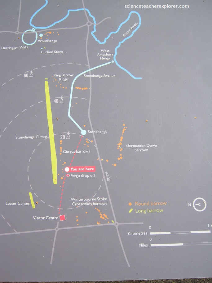
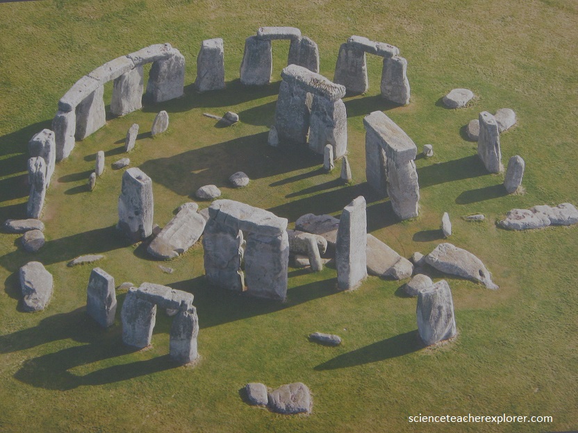
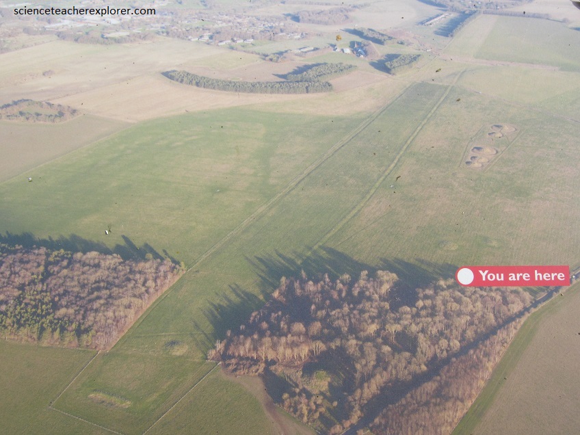
Imaged above, the larger area surrounding Stonehenge is filled up with burial mounds (long barrows) and elongated earthwork enclosures (cursus monuments) that date from the time before Stonehenge. From the time of building Stonehenge there are other temples (henges) and from the centuries after building at Stonehenge had ceased, hundreds of Bronze Age burial mounds (round barrows) were built on surrounding hilltops and valley sides. These monuments, all concerned with burial and ceremony, have been recognized for centuries. But they have now been joined by traces of everyday prehistoric life. Aerial photography, (picture below) has revealed traces of small farmsteads, boundary ditches, fields and trackways. Artefacts collected from the surface of ploughed fields (fieldwalking) provide evidence of both ancient industry and of the places where people lived. The excavations that followed these discoveries have provided detailed glimpses of life in prehistoric times and have shown us how this landscape developed through time.
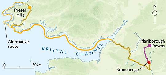
Perhaps the most impressive point about the construction of Stonehenge, is that the extremely heavy stones were transported tremendous distances to be brought to Stonehenge. The big sarsen sandstones were dragged 30 km from Marlborough Downs to the north near Avebury. The smaller bluestones were dragged, and perhaps floated by raft, from quarries in Wales about 242 km away.
Interestingly, among the huge megaliths looming dramatically against the skyline at Stonehenge are some 80 blue-grey stones that form two incomplete rings in the middle of the monument. Known as ‘bluestones’, they are volcanic in origin and have no business being on the chalk downland—they are known to come from the Preseli mountains in south-west Wales, (242 km away). They weigh up to 7 tons each. Outside the bluestones, 56 equally spaced holes were found. These Aubrey holes appear to have contained cremation burials that are dated 2750-2100 B.C.. Between 2000-1100 BC the bluestones were repositioned and the larger sandstone megaliths were erected. Averaging 30 tons each in weight and 6 m, the giant sandstone blocks were connected by lintels (cross-pieces) shaped in a slight curve so that when fitted together they made a circle running around the top, with careful crafted ball-and-socket joints linking the lintels by way of the tenons, to the upright stones for stability.
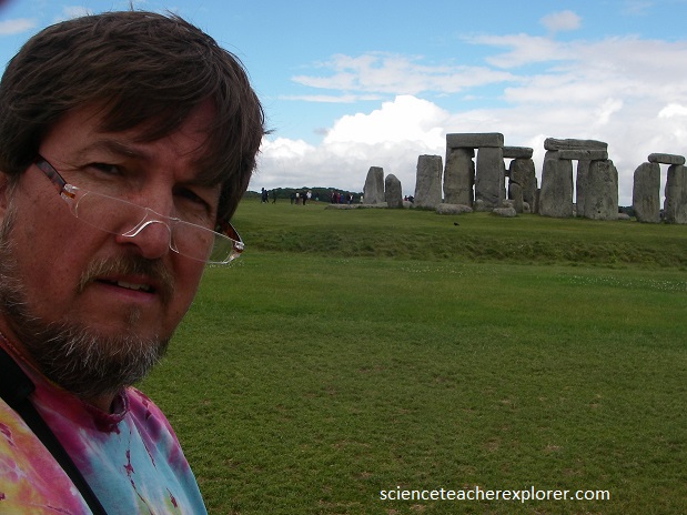
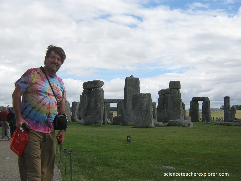
If you stand at the center of Stonehenge on June 21, you can see through a gap between 2 upright stones, under their lintel, with the Heelstone viewed in the middle just poking up above the distant horizon, and that is where the solstice Sun rises. The picture above shows me standing at a location that enables me to see through the middle that is aligned with the Heelstone and the distant horizon.
Stonehenge is the supreme achievement, and most archaeologists today agree that its purpose was religious, and probably also astronomical. With the help of a computer, the US astronomer Gerald Hawkins has proposed a number of important alignments: sightlines for the rising and setting of both Sun and the Moon throughout the annual calendar, as well as more complex astronomical calculations that include the movement of the constellations and the prediction of eclipses.
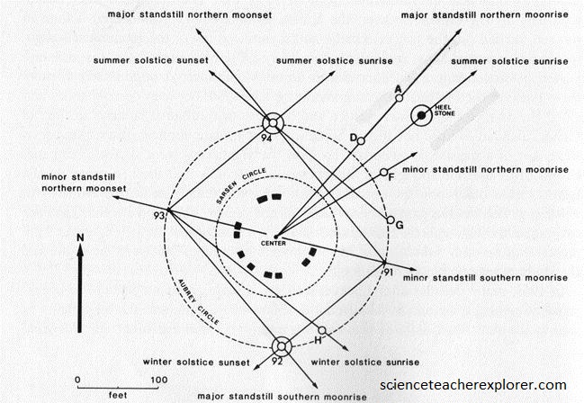
The astronomically significant direction on the horizon is usually one of the 4 cardinal directions or one of the 4 solstitial directions. The 4 cardinal directions are north, east, south, and west. The 4 solstitial directions are toward either sunrise or sunset on the dates of either the summer solstice or the winter solstice. These solstitial directions are the Sun’s extreme north during summer and the Sun’s extreme south during winter. The days of the solstices are close to June 21 and December 21 every year.
Starting in 1965 with Gerald Hawkins, the astronomical alignments and the eclipse computer were widely taken to be the critical components of Stonehenge, to the exclusion of most else. With this, astronomers were telling us that Stonehenge was just one big astronomical observatory and computer. The fusion of the 2 themes was that some mystic Druid astronomer-priests ruled their society and built Stonehenge for their own astronomical observatory.