Glacier N.P., B.C. 2022
While traveling in Canada in August of 2022, Becky (my wife) and I explored Glacier and Mount Revelstoke National Parks. Glacier National Park and adjacent Mount Revelstoke National Park are in the eastern British Columbia at the same latitude as Yoho and Banff National Parks farther east. Unlike Yoho and Banff however, which lie within ranges of the Rocky Mountains, Glacier and Mount Revelstoke Parks are set among the more jagged and spikey peaks of the Selkirk Mountains, with only a strip along the eastern side of Glacier Park being part of the rounded smoother slopes of the Purcell Mountains.
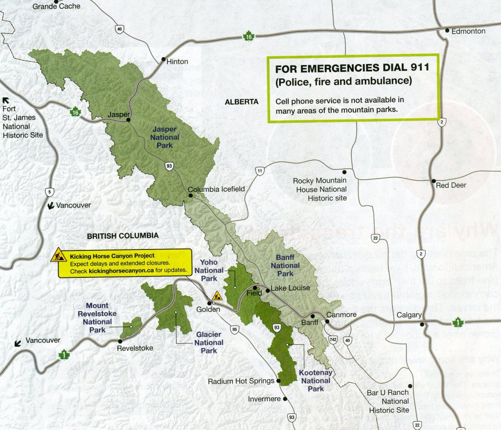
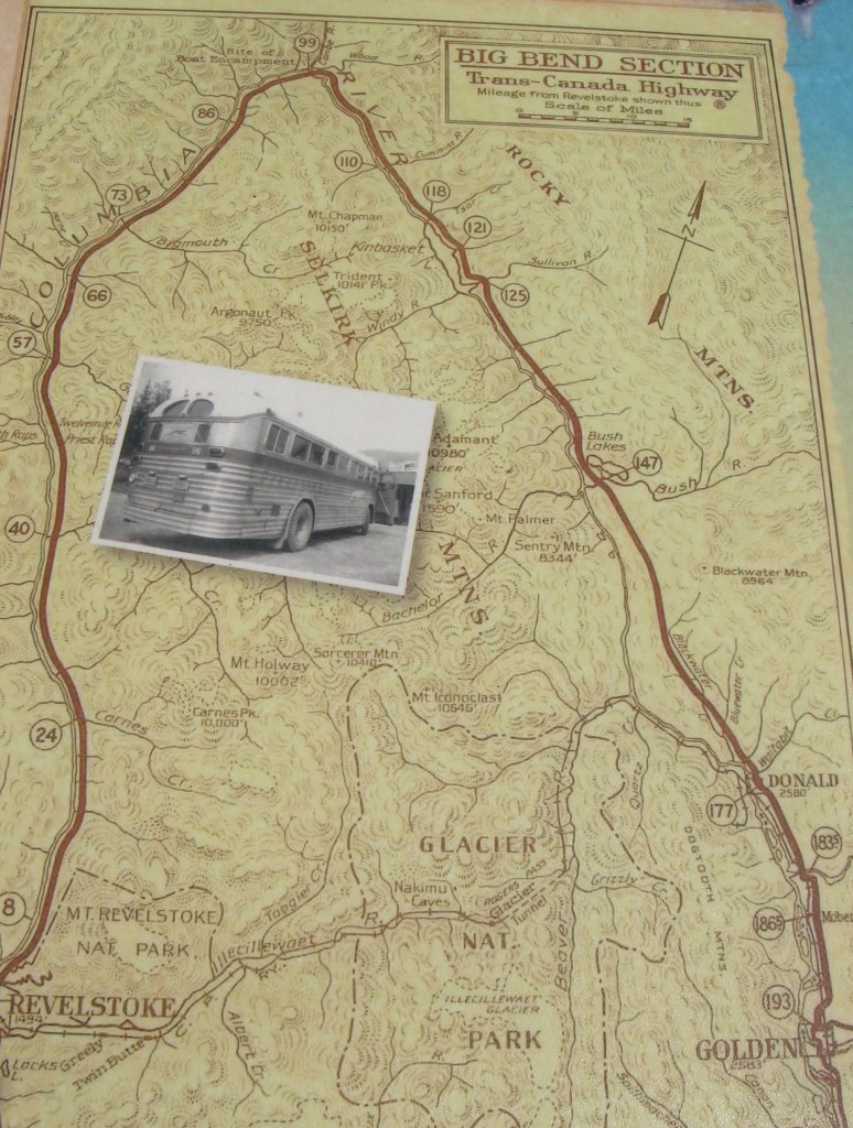
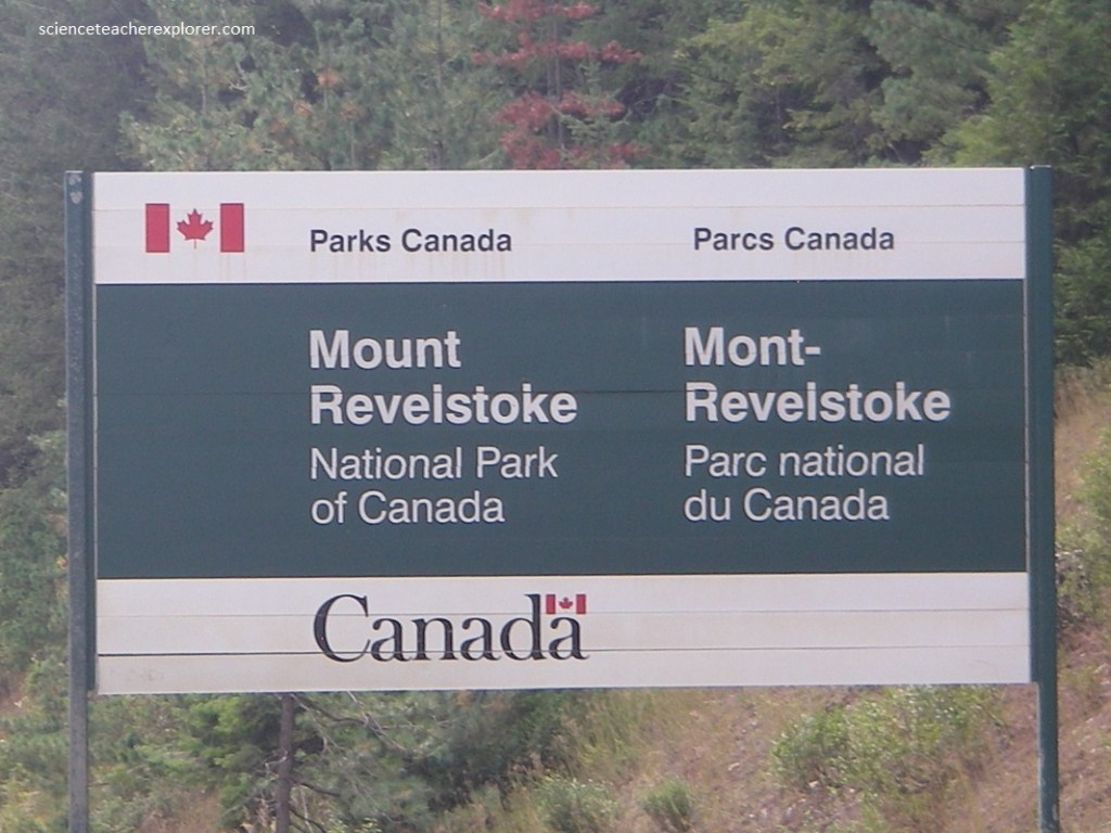
Glacier National Park lies in eastern British Columbia with its center near Glacier station on the Canadian Pacific Railway at 1170 30′ longitude and 51016′ latitude. The Trans-Canada Highway enters he northeastern corner of the park by crossing a line surveyed more or less directly across the Beaver River valley. Form the eastern end of this surveyed line the boundary trends irregularly southeastward along the divide between Beaver river (in the park) and various small tributaries of Columbia River to the east. In all, Glacier National Park comprises some 1000 square kilometers, much of it consisting of superb mountain scenery.
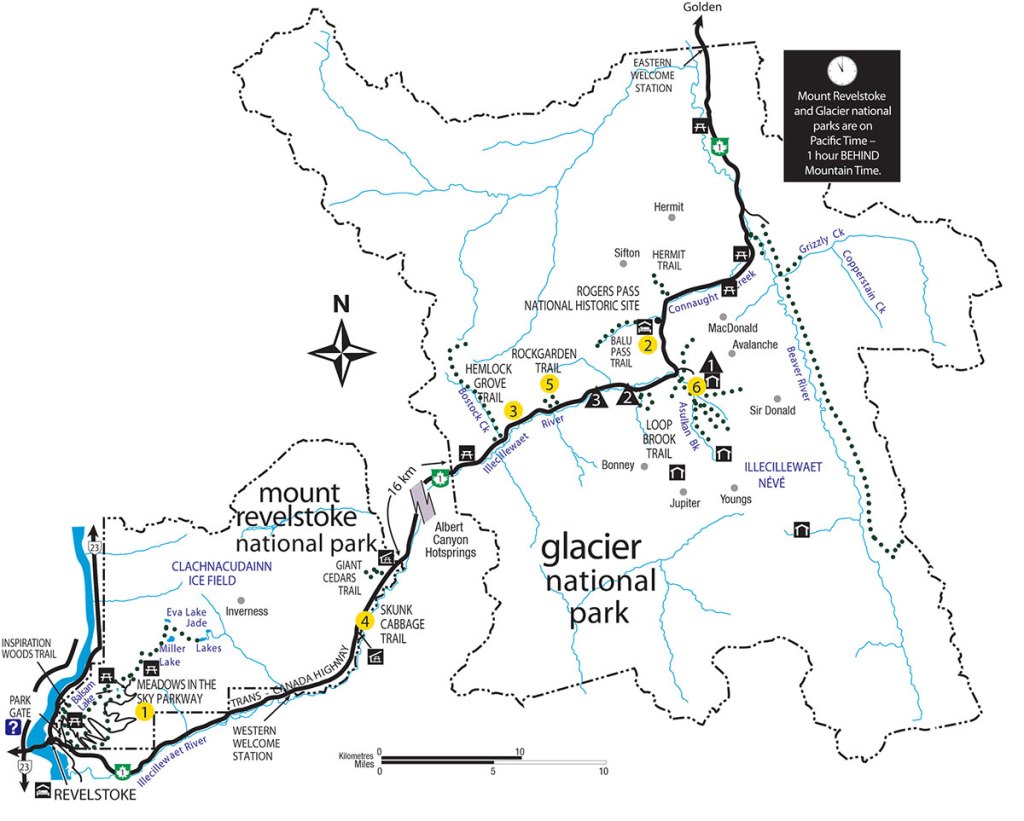
Mount Revelstoke National Park lies about 16 km west of Glacier Park. The Trans-Canada Highway follows along the northwestern bank of the Illecillewaet River from its headwaters in Glacier Park all the way to the city of Revelstoke (pictured below).
Becky and I started from Golden, British Colombia and entered Glacier National Park from the north called the “Eastern Boundary” of Glacier National Park.
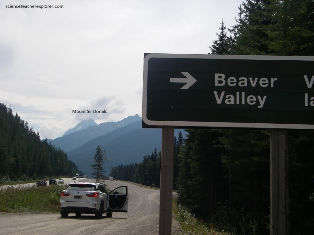
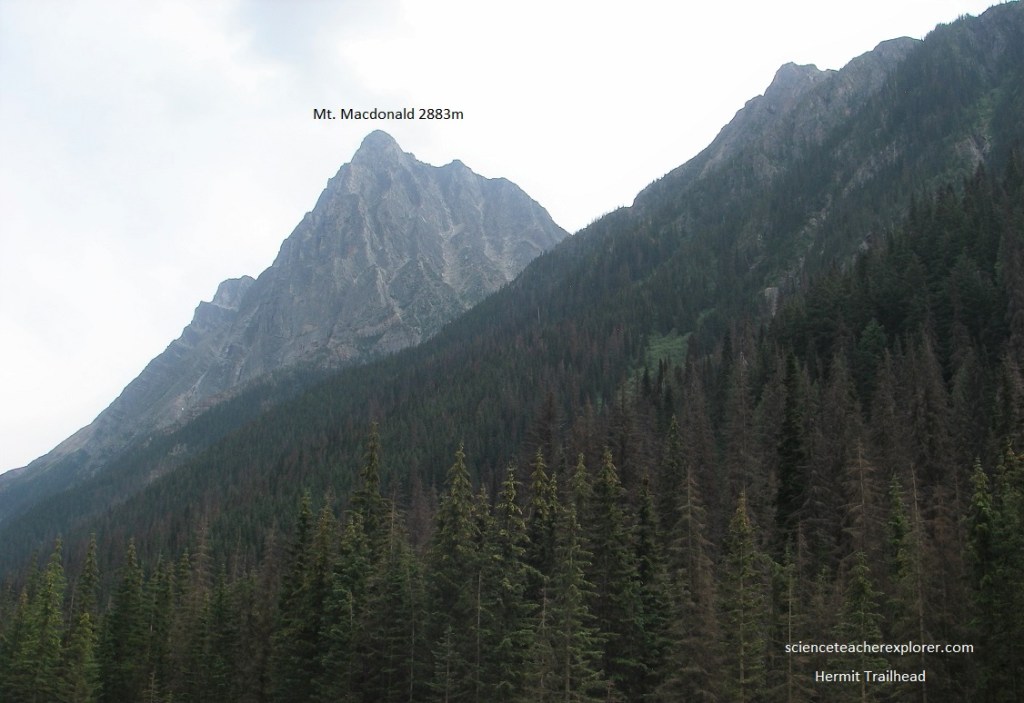
The Trans-Canada Highway begins its course by the Beaver River. The Beaver River wanders on the flat with islands and bends in a course that is choked with the very heavy load of material washed out from melting glaciers long ago. Pictured below, looking southward we could see where the treed hillside nearby intersects the line of distant high mountains. This marks the valley of Connaught Creek and the route through Rogers Pass that is followed by the Trans-Canada Highway as it crosses the high mountains. The first tall distant peak to the right belongs to the Sir Donald group. Nest closest is a long ridge leading right to a horizontally lined, open “V” peak, Mount MacDonald.
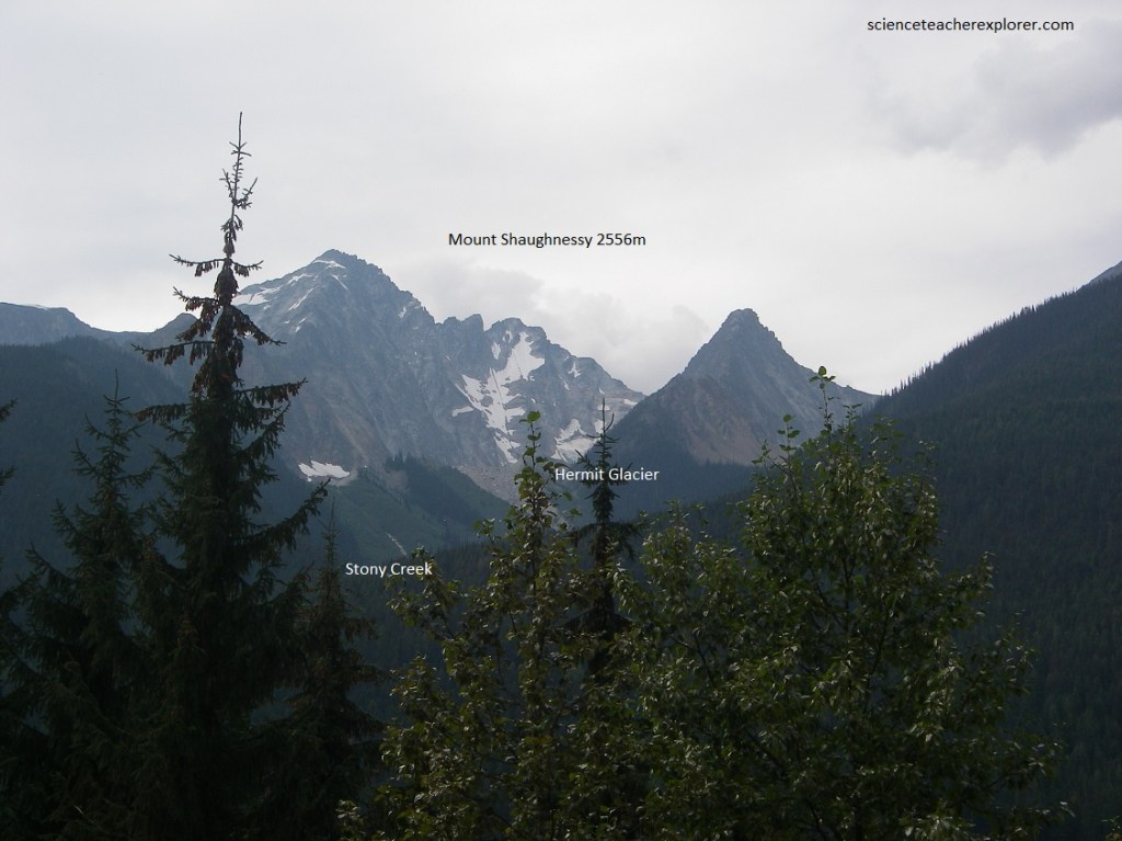
Pictured below, Stoney Creek on the opposite side of Beaver River brings in a great flood of sand, silt and gravel, producing an ‘alluvial fan’ that pushes out into the bottom of the main river valley. The jagged peaks opposite are climaxed by Mount Shaughnessy, (elevation of 2556 m), and are characterized by numerous beautiful glaciers, remnants of morainal material, avalanche scars which take the form of light green patches in the darker woods in the lower sections, and here and there the threads of meltwater streams.
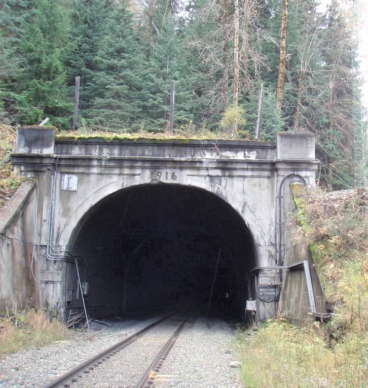
Pictured below is the eastern portal of the famous Connaught Tunnel. This is where trains plunge into and through the heart of Mount MacDonald to emerge at Glacier station (8.082 km), thus avoiding the difficult and dangerous Rogers Pass. The tunnel is ventilated by a huge fan at the Glacier station end.
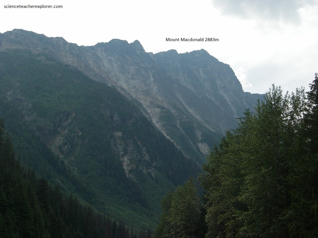
Pictured below, a vertical cliff of Mount MacDonald grades gradually downward into the very steep lower slopes. These and the great cliffs and steep slopes in the lower part of Mount Tupper and “The Hermit” show why avalanches are very common in Rogers Pass and why the railroad in its early days had so much trouble. This route eventually became so troublesome that the railway abandoned it in favor of the Connaught Tunnel, some 7 km long, right under the peak of Mount MacDonald.
Pictured below, along a stretch of about 2.2 km, engineers of the Trans-Canada Highway have built very strong reinforced-concrete snow-sheds into the hillsides to allow avalanches to thunder down and over the highway into the valley bottom just below. Here and there along the road, mounds of earth disrupt the flow of avalanche material. Sometimes avalanches in these mountains are deliberately set in motion by artillery fire so that there can be some measure of control over them.
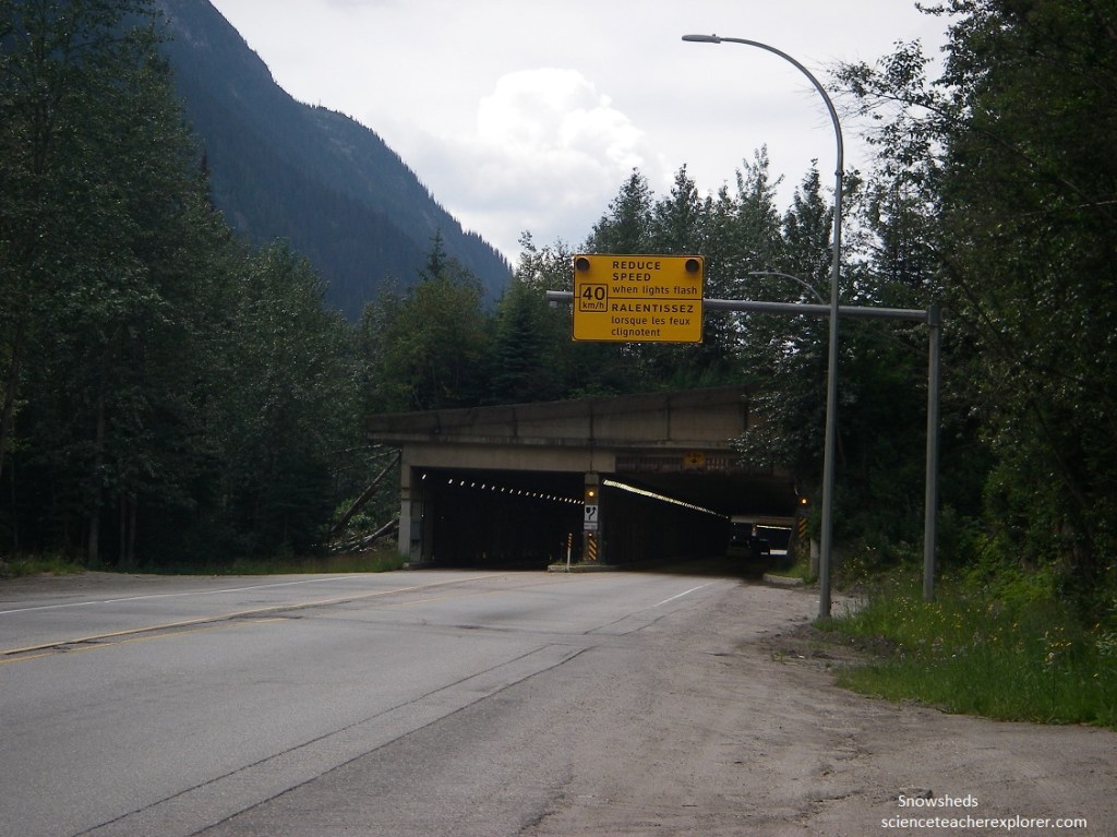
Pictured above, it is interesting to note that in the design of these snow-sheds the engineers are cooperating with Nature rather than trying to fight her; they mold the snow-sheds into the general contours of the hills and allow the avalanches to go more or less unimpeded over the top of the road, instead of setting for themselves the almost impossible task of building a great barrier to stop the avalanches altogether. Here and there, I noticed on the opposite side of the valley, particularly in the Rogers Pass section, piles of gravel and rocks that have been placed carefully in an avalanche path to help break up the flowing avalanche.
Pictured above and below, the Trans-Canada Highway occupies the very narrow bottom of the steep valley between Mount MacDonald (east) and Mount Tupper (northeast). In this view, from the southwest of Connaught Creek valley, the steep rugged slopes show clearly why the area is so prone to snowslides in the spring. The main line of the Canadian Pacific Railway used to go through this valley but was abandoned in favor of a tunnel underneath Mount MacDonald.
“The Hermit” (left) through the Connaught Creek valley within Glacier National Park 2022
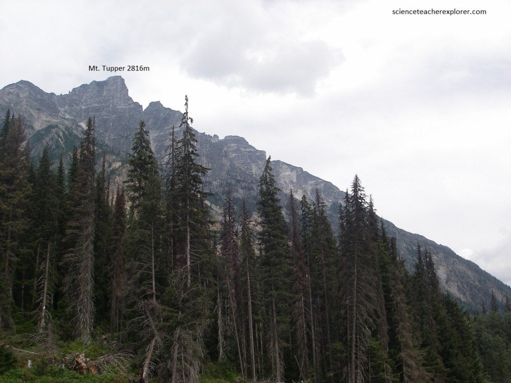
Pictured above, eastward along the Trans-Canada Highway, (here from the Hermit Trailhead), the great mass of mountains is climaxed by Rogers Peak high and at the back, with glaciers in the upper cirques and sharp ridges in between. “The Hermit” and Mount Tupper, rectangular and blocky looking, make very bold peaks in the complex to the left and from here, (the Hermit Trailhead), appear to lie just over the flank of Avalanche Mountain.
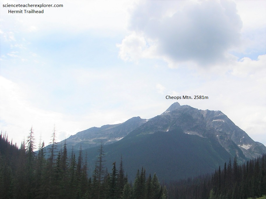
Pictured above, from the Hermit Trailhead, looking west lies Cheops Mountain with its sharp-pointed peak and subsidiary spurs leading in several directions.
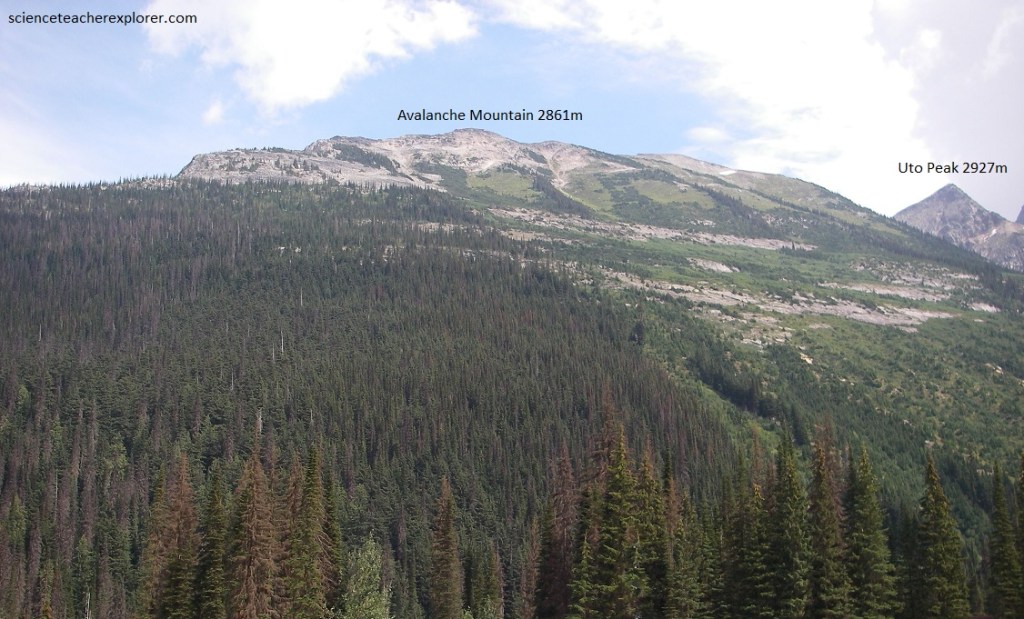
Pictured above, directly east the slopes of Avalanche Mountain show abundant evidence of why it got its name. The larger and darker trees are stripped out in long lanes where snow and ice has cascaded off the upper part of the mountains and avalanched downward. Now, (in the summer), the avalanche paths are marked by much lighter green, low bushes, which grow quickly.
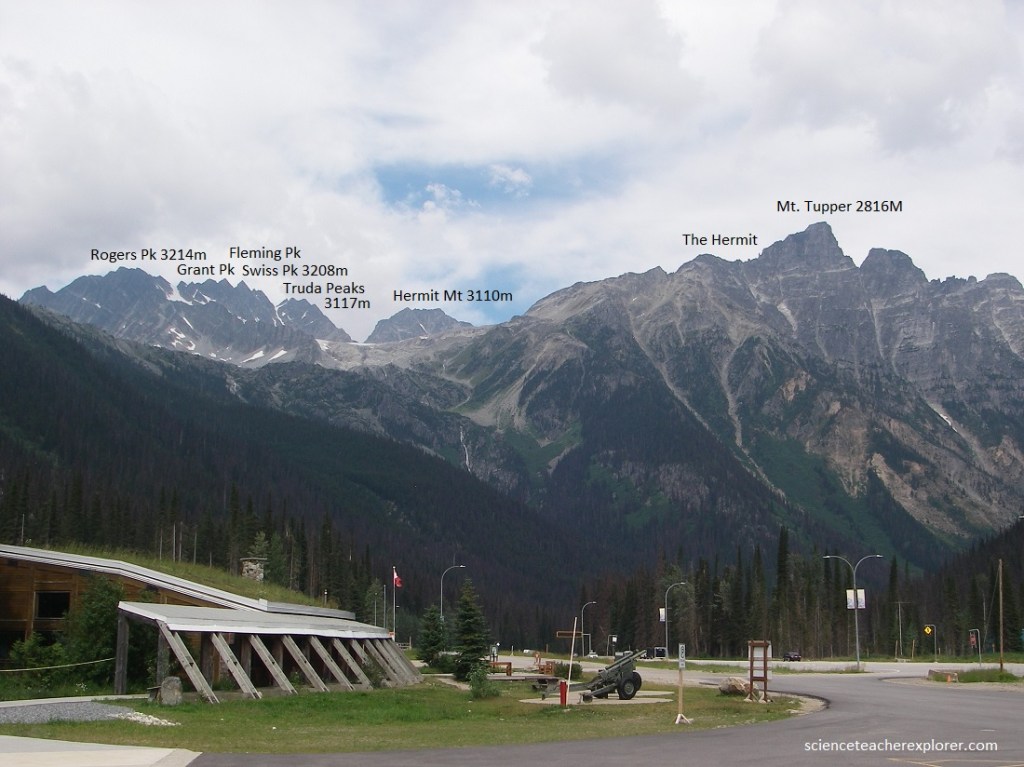
Pictured above, looming above the Trans-Canadian Highway just north of the summit of Rogers Pass are the majestic peaks of “The Hermit” and the immediately adjacent Mount Tupper. Little wonder there is trouble with snow-slides and avalanches with such steep bare mountains so very close to the bottom of the valley. The very jagged peaks of the Mount Rogers complex are cut in massive white, grey and green quartzite of the Hamill Group with their shapes being due partly to erosional history and partly to the presence of joint patterns in these massive but brittle rocks. The mountains all around here show light green paths made when the dark coniferous forests are stripped out by avalanches in the late winter and spring and their places are taken by light green, low shrubs and bushes.
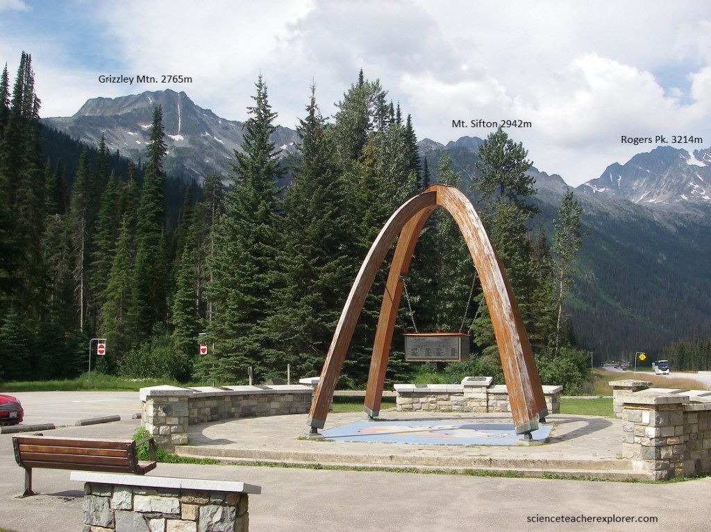
Pictured above and below, at the crest of Rogers Pass in Glacier National Park and surrounded by the high Selkirk Mountains, a monument marks the place where the Trans-Canada Highway was officially opened in 1962.
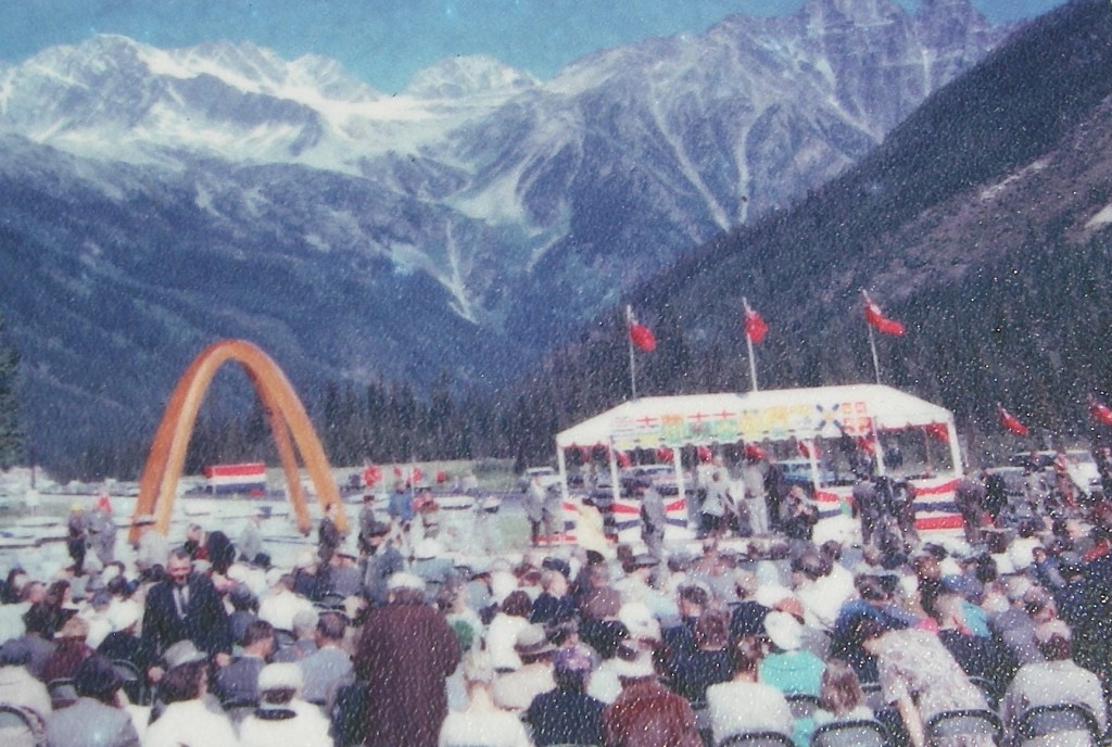
Pictured above, on September 3, 1962, Prime Minister John Diefenbaker officially tamped down the “last patch” of asphalt in the highway opening ceremony here at the Summit Monument. Constructing “the first continuous, all-season, two-lane road across Canada” had taken 12 years and cost nearly $1B. The Tran-Canada Highway stretches 7,821 kilometers from Victoria, British Columbia to St. John’s, Newfoundland. It crosses six time zones and climbs from sea level on each coast to its highest point at Kicking Horse Pass (1,627m) on the Alberta/British Columbia border. Here at Rogers Pass, the elevation is 1,330m.
Before the Trans-Canada Highway was built, the Big Bend Highway connected Golden and Revelstoke with 305 km of gravel road. The route followed the Columbia River as it makes its “Big Bend” around the Selkirk Mountains. The Big Bend Highway, completed in 1940, was the final link in British Columbia’s trans-provincial highway. “The Big Bend” was such a difficult 5 hour trip that some motorists opted to take the train over Rogers Pass with their cars on board, resuming their road trip at either Revelstoke or Golden. “The Big Bend” route served for two decades until it was replaced by the Trans-Canada Highway in 1962.
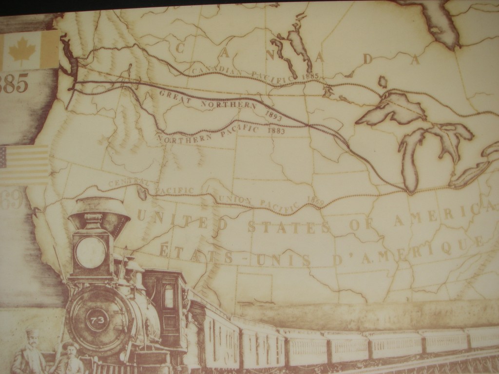
Imaged above, to tie a young Canada together and to eliminate possible competition from U.S. railways, the Canadian Pacific Railway pushed its line across the prairies quickly and cheaply. The route it chose took the track over dangerously steep Kicking Horse Pass in the Rockies and avalanche-ridden Rogers Pass in the Selkirks. Later, the struggle to operate a railway in Rogers Pass gave the CPR reason to regret that choice.
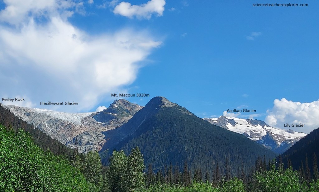
Pictured above, to the south the snowfields on Asulkan Ridge make a conspicuous white view. Looking to the left, the rocky ridge of Glacier Crest is visible and to its left again is just a little of Illecillewaet Neve (snowfield). Below it and to the left of Glacier Crest lies Illecillewaet Glacier, almost entirely hidden from this spot. Pictured above, Illecillewaet Glacier spreads from the Illecillewaet Neve (snowfield) on the skyline over an irregular rocky slope toward the valley bottom. The crevassed old ice contrasts with the patches of more recent snow left over from the previous winter. 50 years ago the glacier extended two kilometers farther down the slope that it does in 2022.
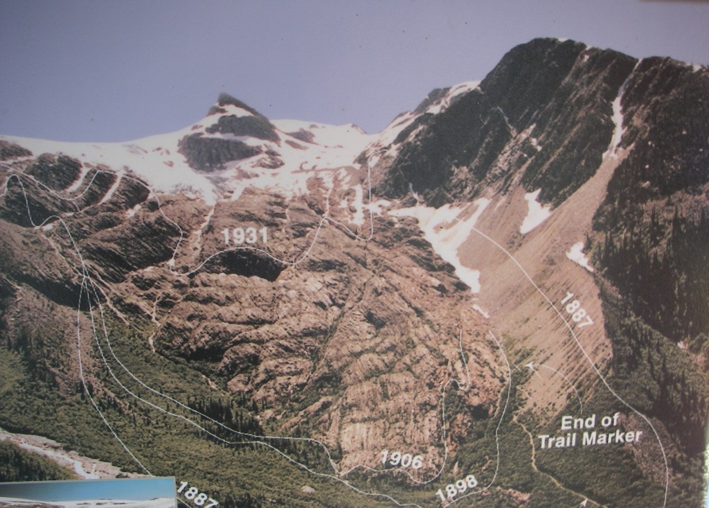
There’s no question that the earth is warming up. Global temperatures are rising faster that at any other time in the past thousand years. Imaged above, between 1850 and 2000, the glaciers in Glacier National Park have receded significantly. Of the 205 glaciers recently studied, they have shrunk by an average of 57%. This means that ice covering an area of 176.4 km2 has disappeared. In the short term, melting glaciers may add extra water to mountain-fed streams and rivers, but in the long term, reduced glacier ice will probably mean less runoff in the summer months. This decrease in the water supply will likely causes changes in flow patterns of the rivers and streams. These changes could have significant impacts on fragile wetland habitats.
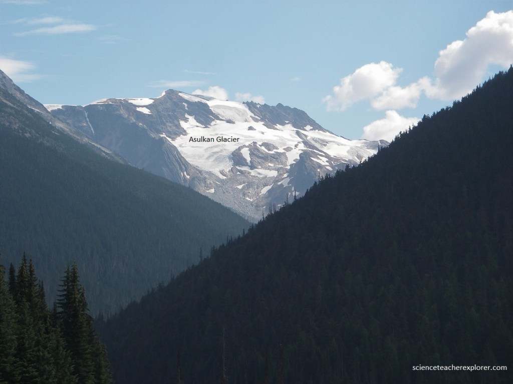
Pictured above, the wooded slope above Glacier station is the end of Asulkan Ridge. A small bit of Asulkan Glacier shows in the “V” of the next valley to the left. South and southeast the valley of the Illecillewaet River shows its branching with Asulkan Brook to the south and Illecillewaet Brook to the southeast. The great scar on the rocks, marking where Illecillewaet Glacier used to extend down farther that it does in 2022, and Glacier Crest on the skyline are spectacular from this section of the Trans-Canada Highway.
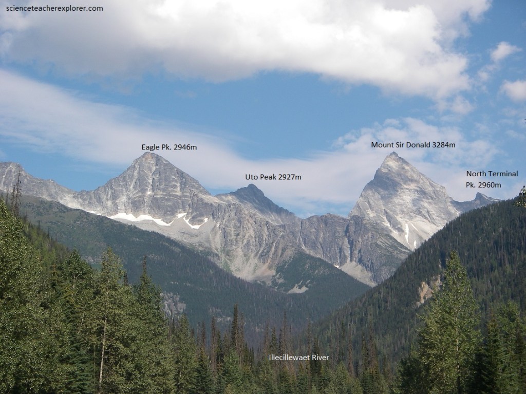
Pictured above, eastward, uphill along the Illecillewaet River Valley, the four jagged peaks of the Sir Donald Range dominate the skyline, (from left to right : Avalanche, Eagle, Uto and Sir Donald).
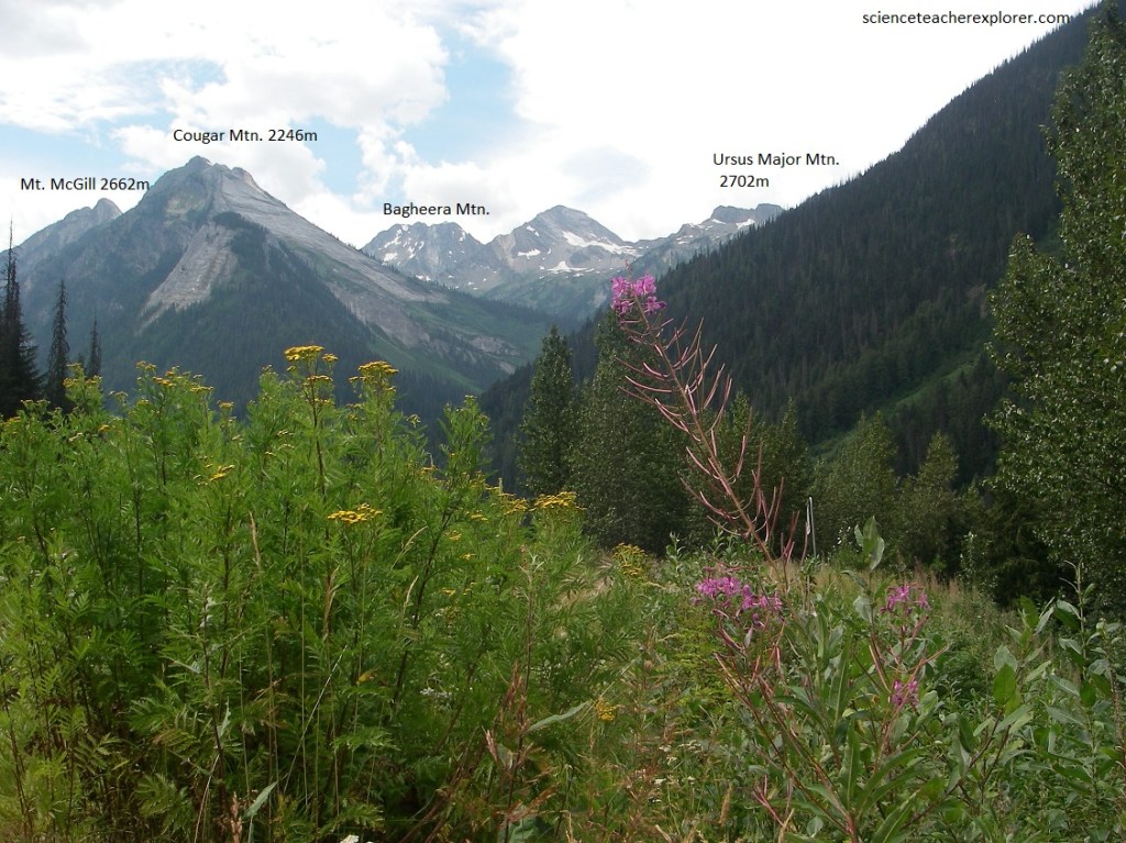
Pictured above, the mass of Cougar Mountain with various spurs and snow and ice patches lies to the northwest along the Trans-Canada Highway. The peak on the left is a ‘dip’ slope of grey limestone. In the valley of Cougar Brook this limestone has been dissolved by underground waters to form the Nakimu Caves and an unusual underground drainage system.
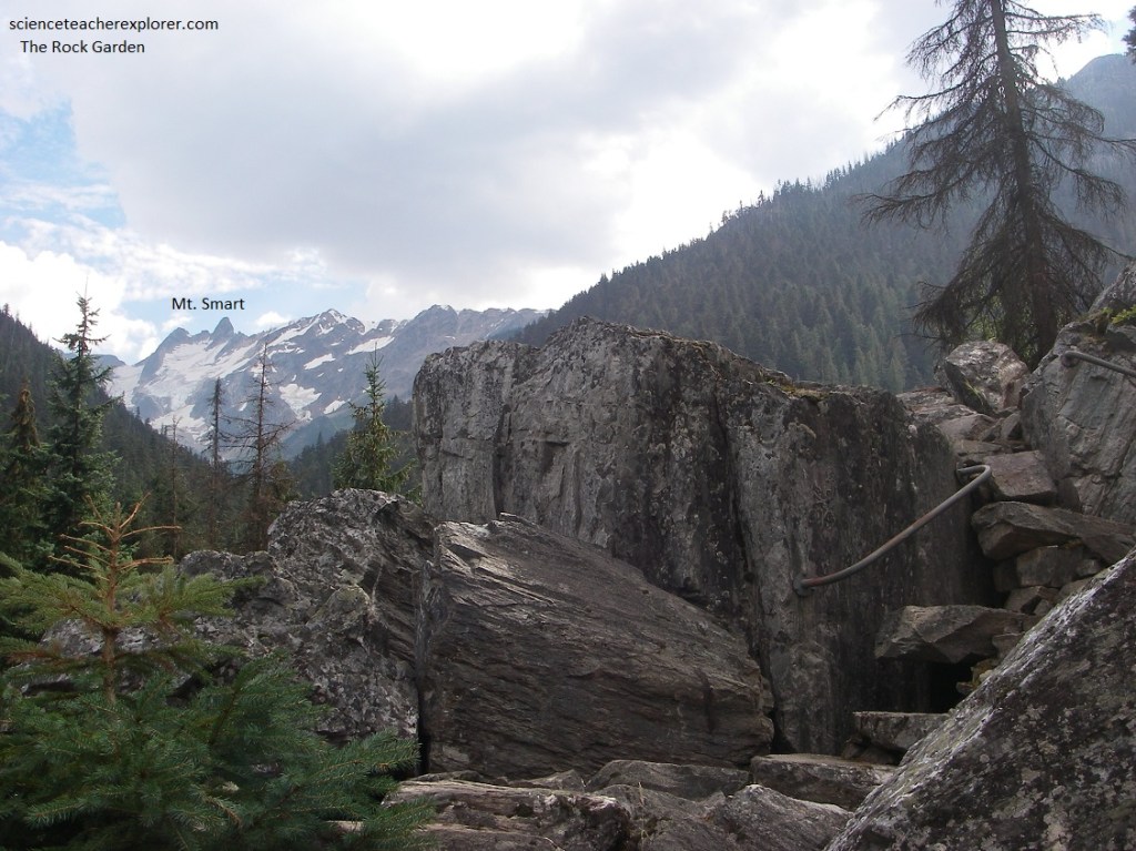
Pictured above, Becky and I took a the “Rock Garden Trail” that offered rock staircases and stepping stones to a viewpoint overlooking glaciers to the south, towards Mount Smart and Oliver (2520m). The partial glacier we could see is to the Bonney Icefield and Glacier. The steep slope here is an outlying spur of Ross Peak. The rocks here along the highway are of a metamorphized greenstone and quartzite, that is a rock that began as a sand made up largly of grains of quartz, and later recrystallized over a long period to form dens rocks such as these.
Pictured above, entering the Mount Revelstoke, we followed the valley of the Illecillewaet River on the Trans-Canada Highway for the next 18 km. Meanwhile, Becky and I stopped at the “Giant Cedars Trailhead” to explore the local plant life. Unfortunately, the trail was temporally closed due to “fallen tree danger”.
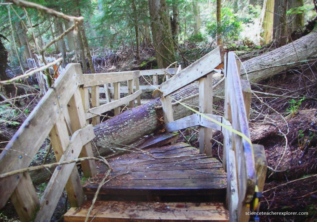
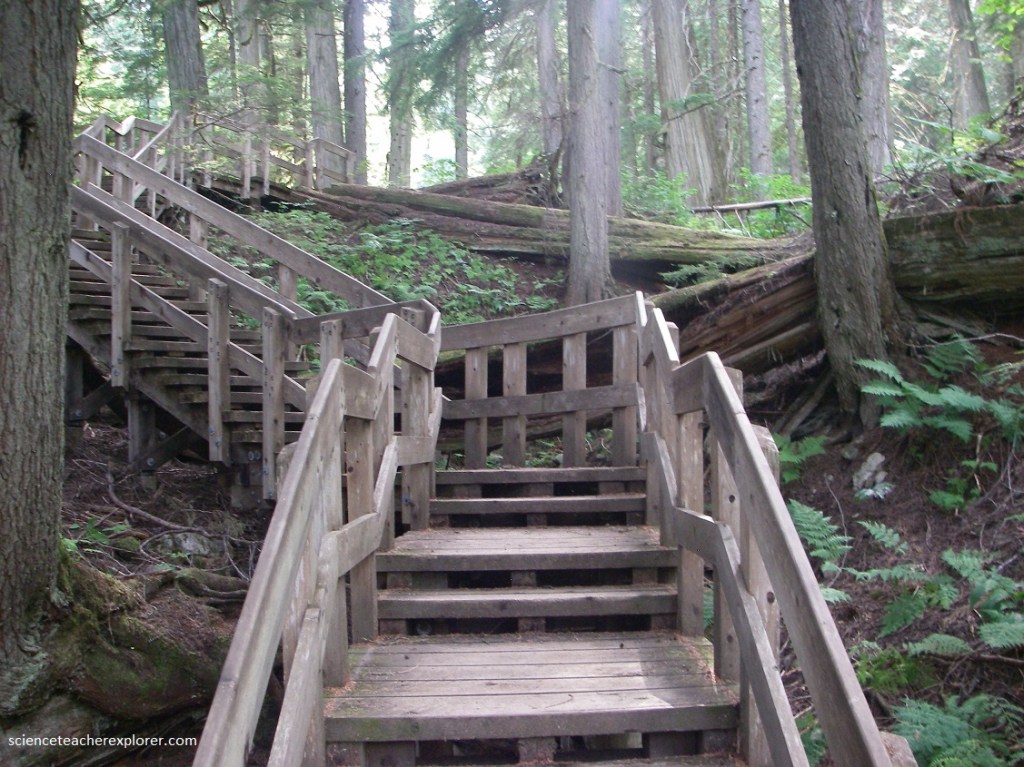
The rich soil, humidity and dense plat life of the Giant Cedar forest are really hard on built infrastructure. Falling trees are important to forest health but destructive to man-made structures. The boardwalk is maintain every year to be sure it is safe for visitors. Even so, many boardwalk support posts were starting to rot and need to be replaced. Pictured above, in the winter of 2021-2022, falling trees and heavy snow caused more damage to the boardwalk. For safety and to protect this sensitive environment, the boardwalk was closed while we were there.
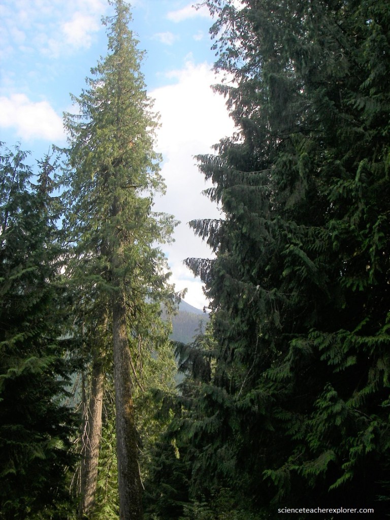
Giant Cedars Boardwalk Trail is in the inland temperate rainforest of the Columbia Mountains. Pictured above and below, large cedar and hemlock trees climb higher than the eye can see. At 100s of years old, many of these trees are nearing the end of their lives. When the giants fall, holes open up in the canopy letting sunlight reach the ground. This is the beginning, (or the end), of a natural cycle. The downed trees provide food for plants and insects. The light allow sun-dependent trees and plants to finally grow. Eventually, many years later, they will again be shaded out by new cedar and hemlock. Whether one old tree falls or many are blown down in a wind event, it is an important part of a healthy forest.
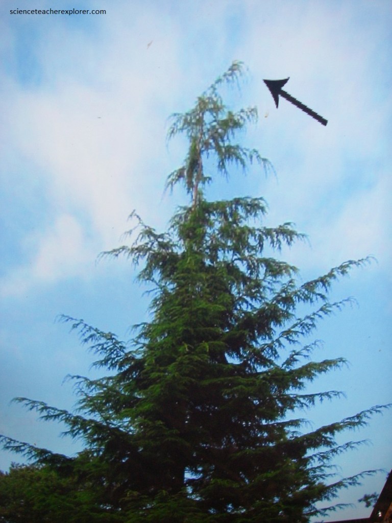
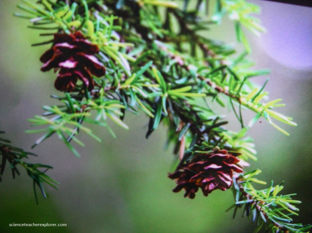
Pictured above and below, is a photo of a “Western Hemlock”, (Tsuga heterophylla), found at the Giant Cedars Trail within the Mount Revelstoke National Park. Hemlock needles are short and vary in length from 0.5-2 cm. Pictured below, the cones are small (1-3 cm) and the leader, or topmost vegetative shoot, is droopy, (pictured above).
In the shade below the forest, spiky devil’s club are dwarfed by the trees but still taller than us. The rich, moist soil supports lush carpets fo plant life spreading out around the trees.
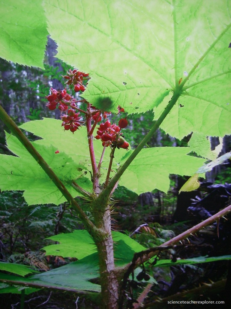
Pictured above, a common shrub in the “Giant Cedars Trail” rainforest, Devil’s club (Oplopanax horridus) is a member of the ginseng family and is an important medicinal plant to many indigenous peoples. It is still used today for ailments including stomach ulcers, diabetes and arthritis. Devil’s club grows in seeps, where there is running water underground. The stems are covered in sharp spikes that break off easily and inject an irritant into the wound. The bright red berries are not edible by humans, but bears devour them.
Pictured above, the Giant Cedars Boardwalk is home of some of the oldest trees in the Columbia Mountains. The largest members of this forest are the shaggy-barked western red cedar and the furrowed, dark brown western hemlock.
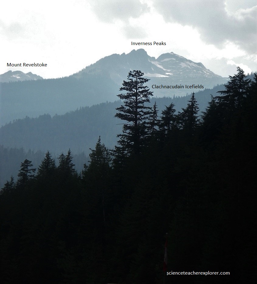
Mount Revelstoke National park consists of mountains rising from the valley bottoms at 560 m above sea-level to well over 2,700 m. The uppermost parts are generally bare and rock and the scenery tends to be very sharp and jagged as it is in most of the Selkirk Mountains. The lower slopes, however, are rounded and covered with extensive and luxuriant forest growth. We headed westward along the Trans-Canada Highway, along the very margin along the Illecillewaet River. Pictured above, the mass of quartzite, schist and limestone of the Inverness Peaks rise high on the right, with Mount Revelstoke just to the left across and down the valley of the Illecillewaet River. Just below and all along the road here the Illecillewaet River runs swiftly toward its junction with the Columbia, carrying quantities of mud, silt and sand as its part in the ceaseless wearing away of the mountains. This is because today’s water is yesterday’s melting snow in the snowfields and glaciers that lie at the headwaters of almost all the streams in the Illecillewaet River system.
