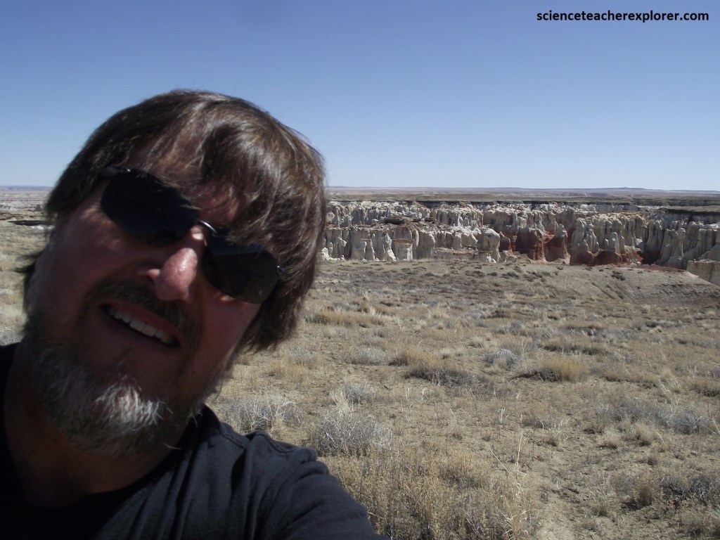
The Hopi Way, AZ 2024
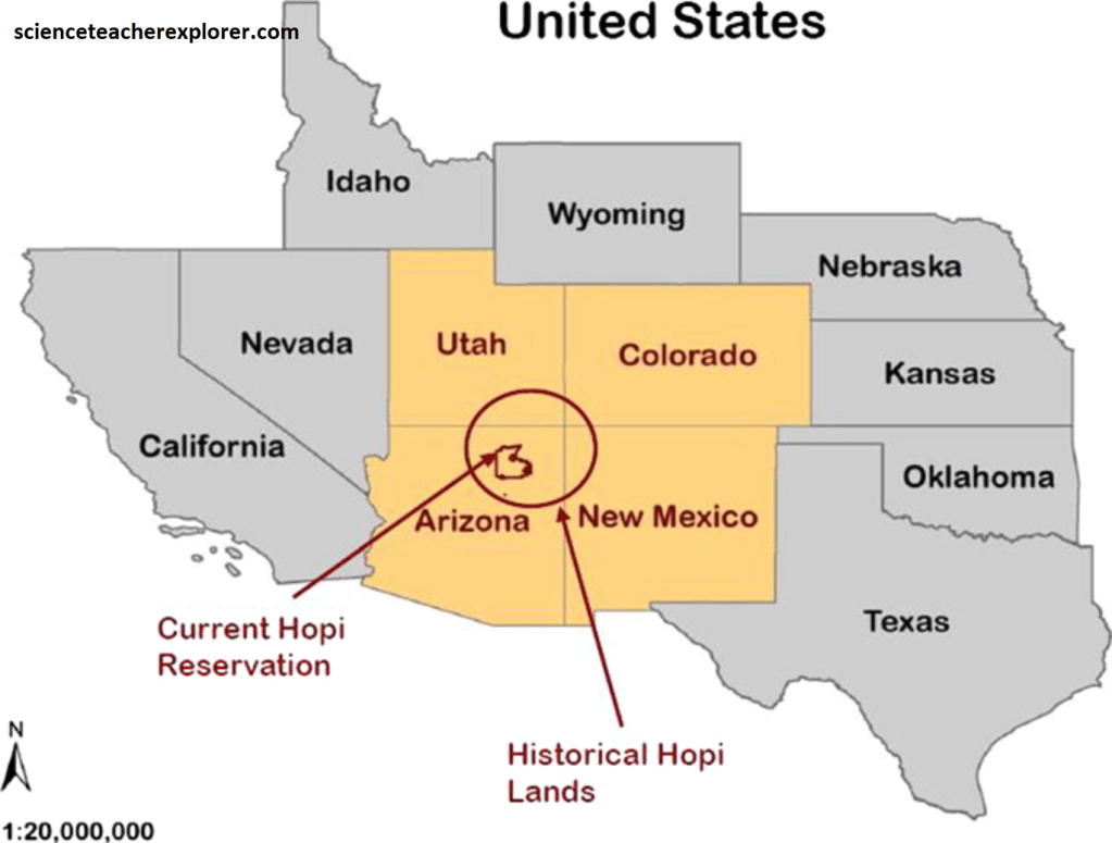
On my way to the 2024 Solar Eclipse in Texas, I drove through the Hopi Nation in Northern Arizona. The Hopi have always lived in the Four Corners region of the Colorado Plateau. Even though the legal boundary of today’s reservation has confined them to a relatively small land mass in comparison to the Navajos’ reservation, evidence of the original boundaries, (or tutsqua), was established by tradition and history, are Navajo Mountain to the north, down the Colorado River to Bill Williams Mtn. to the west, over to the San Francisco Peaks, along the Mogollon Rim to the Zunis’ Blue Lake for the southern boundary, and north to Canyon de Chelly and the Four Corners area for the eastern boundary.
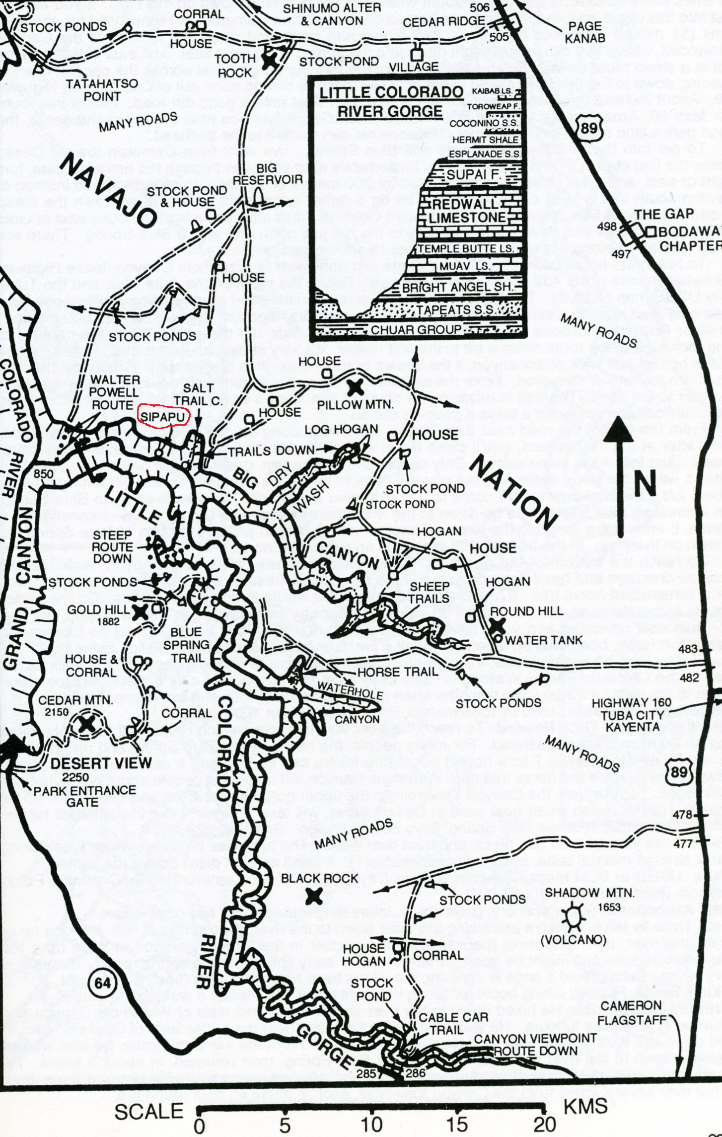
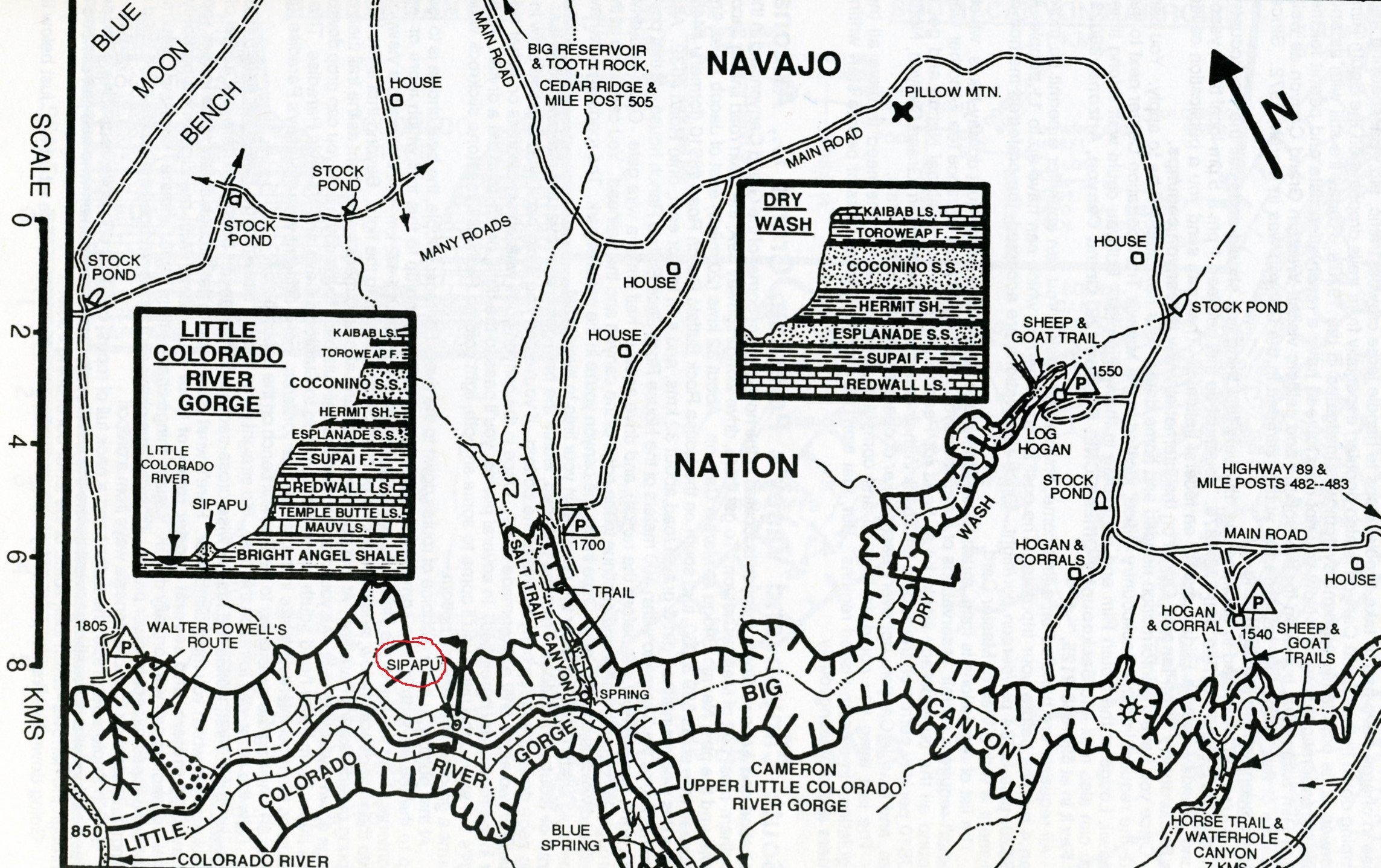
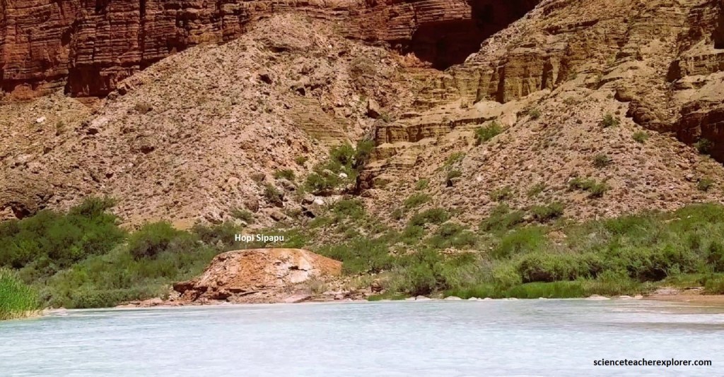
According to the interesting Hopi religion: The Hopis’ emerged from the underworld through a sipapu, (an opening), in the Little Colorado River Canyon. {Note: The maps below were taken from “Canyon Hiking Guide to the Colorado Plateau, 4th Ed.” Kelsey 1999}
They came into this, the Fourth World, with the help of a small bird known as the shrike, which brought them into the world of light. Here they made their vow of righteous living to “Sootukwnangwu”, the Supreme Creator. “Masauwu”, (the guardian spirit over the land), told the Hopis that they were to serve as the earth’s steward once their mandated four migrations to the north, south, east, and west in search of “tuuwanasave”, or earth center, before it comes to an end. The center point of the cross formed from their four directional routes is the Hopi mesas. This was the chosen place because it was a harsh enironment where adherence to the laws of the Supreme Creator must be followed exactly to ensure the survival of the clans. I decided to explore these mesas by driving from Moenkopi to Kearns Canyon on AZ 264, imaged below.
The Hopis have strictly adhered to a sophisticated ceremonial calendar. Specific holy men in each village continue to determine the timing of individual ceremonies by the position of the sun, similar to the public domain image below. Most Hopi festivals are keyed to a similar combination of solar and lunar events, (but their highest festival, Soyal, is about as close to the day of the winter solstice as they can make it by observation of the sunrise and sunset on the horizon. The date of Soyal each year is determined by a village elder called the taw-mongwi or Sun Chief. Standing at a favorite observation spot on Second Mesa, he carefully observes sunset over the San Francisco Peaks, surely the most prominent landmark visible from their high plateau.
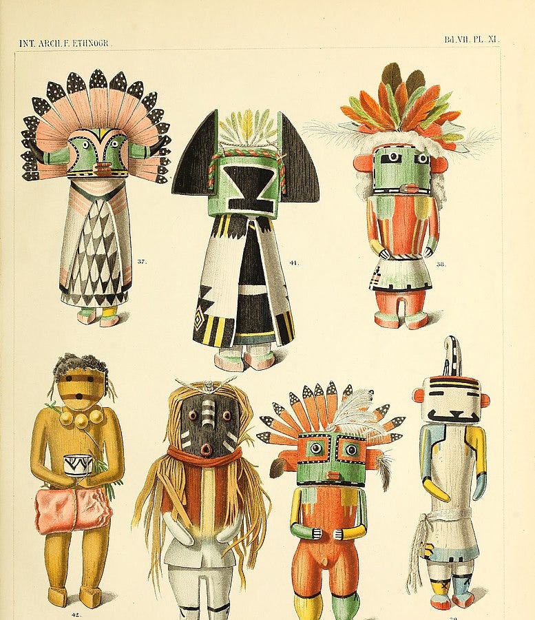
“Katsinas”, or kachinas, as they are popularly called, are the very important spirit beings in Hopi cosmology who assure rain for the Hopis and all people on earth. The Katsinas visit the Hopis and bring gifts. At the end of a dance, prayer feathers are given to the katsinas so that the prayers for rain and good things will be carried in all directions. These dances are the way of communicating the Hopis’ needs to the Supreme Creator. Katsina dances are not always open to non-Hopis, (including me). {The images below are of public domain and generously shared by Hopi artists, i.e. Ray Naha on the right}
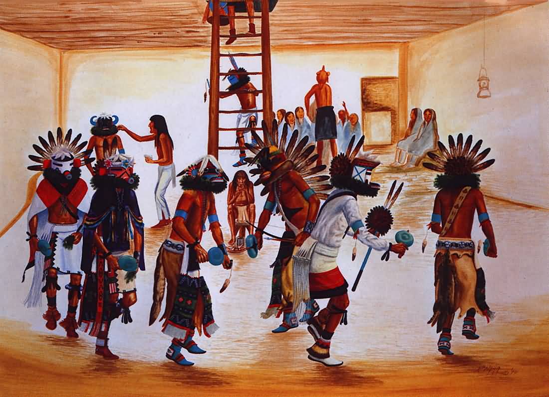
Each of the villages on my drive has a number of kivas, or underground chambers, entered through a hole in the roof. Specific societies use the kivas for meditation, prayer, and preparation for their own important ceremonies. One of the primary rules on the Hopi Nation, are photographing, recording, and sketching villages and ceremonies are strictly prohibited by non-Hopi. So, I am very careful of not doing this and sticking to the distant geography of the region, without close-up shots of the villages.
As my drive headed southeastward away from Tuba City on Rte. AZ-264, it soon swept into the village of Moenkopi. Though the village was surrounded by the Navajo Indian Reservation, it was a Hopi community, the first of several to be seen along the way. The settlement’s name means “place of running water,” and year-round springs do indeed keep the surrounding fields green and the local fruit-trees productive. [When Mormon explorer/missionary Jacob Hamblin met the Hopis in 1858, there was no permanent village here. Hopis gradually built the village beginning around 1870. Hopi farmers from the village of Oraibi, more than 48 km away by trail, managed large cotton farms in the very fertile Moenkopi Wash, running several times a week from home to their fields]. Present-day Moenkopi actually consists of two villages. Upper Moenkopi is the more modern, established in the 1930s around the Bureau of Indian Affairs Day School. Lower Moenkopi was more traditional in its lifestyle, maintaining close religious ties to Old Oraibi.
Moenkopi Wash is one of five washes that drains Black Mesa, This major drainage, made primarily of Chinle Sandstone, forms the lower section of Blue Canyon, (pictured above). An older name for this wash, found on the Dominguez-Escalante map of 1776, is Cosonias, (Hopi word for the Havasuai Tribe, who lived there at the time).
Pictured above, the road AZ-264 climbs gradually away from Moenkopi ad crosses the northeastern limits of the Painted Desert, (a dry and daunting realm that supports little more than tufts of grass, resilient sage-brushes, and a few scrubby junipers. The desert rolls far into the distance, where mesas loom along the horizon. What makes the unbroken vistas truly special, though, are the vivid colors of exposed sandstones and shales, which are banded with an array of reds, whites and pinks.
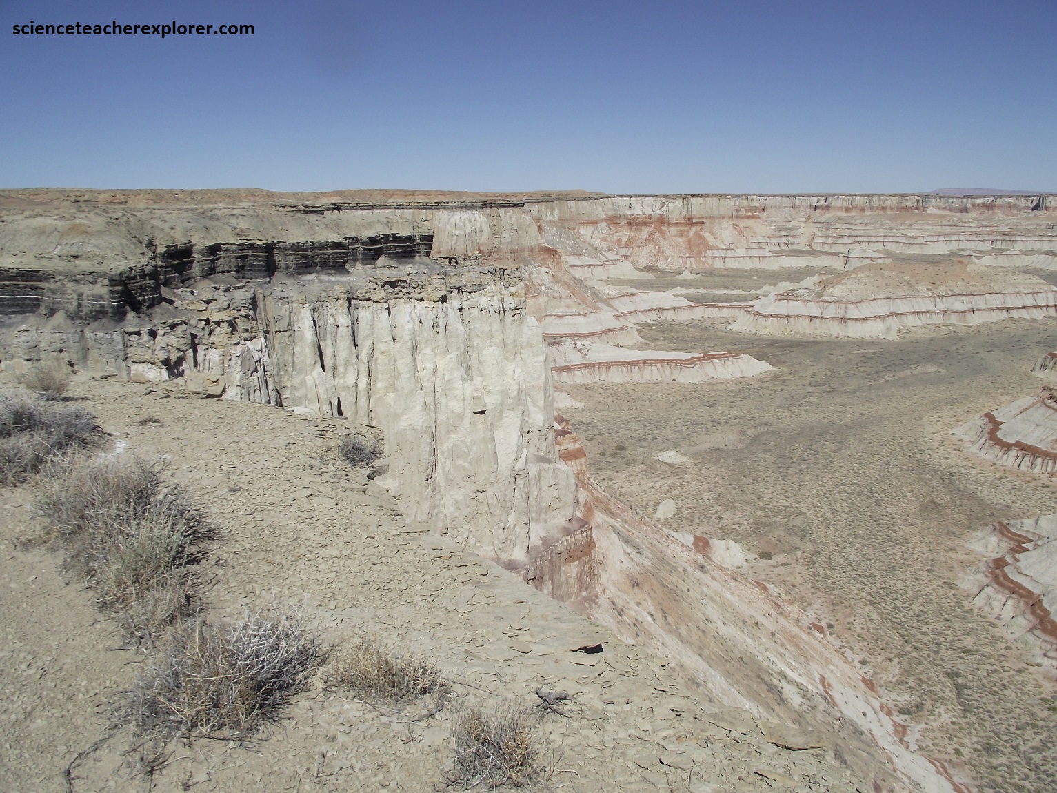
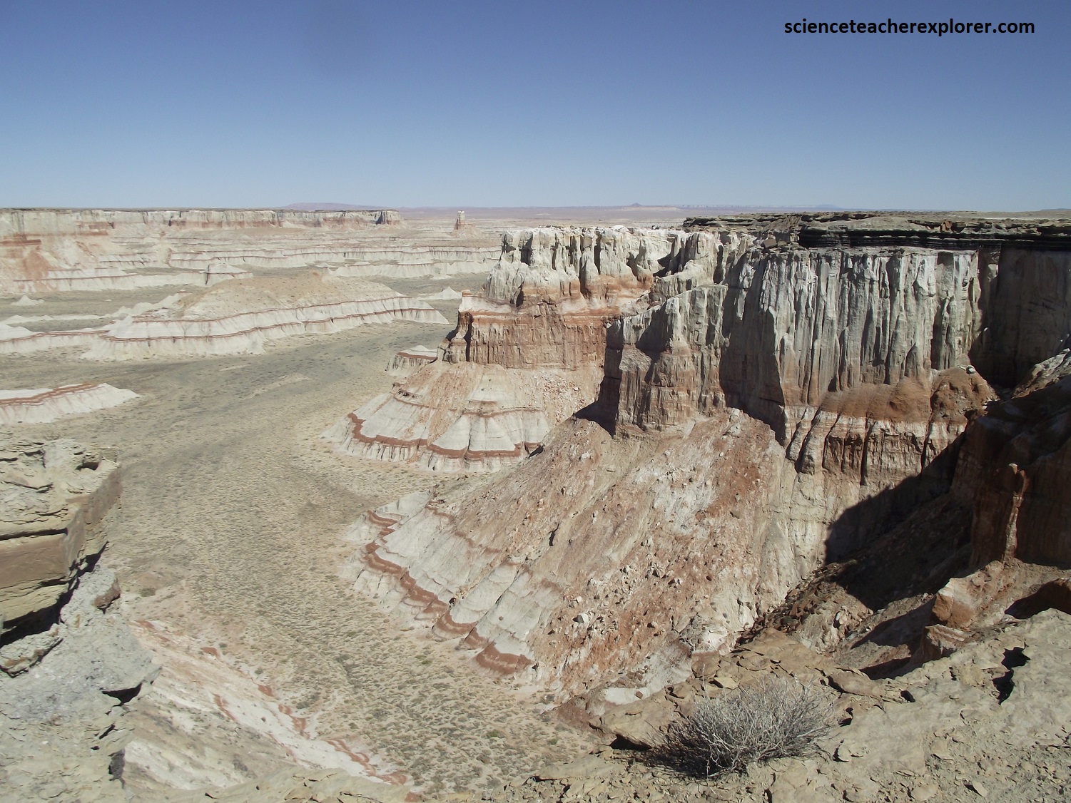
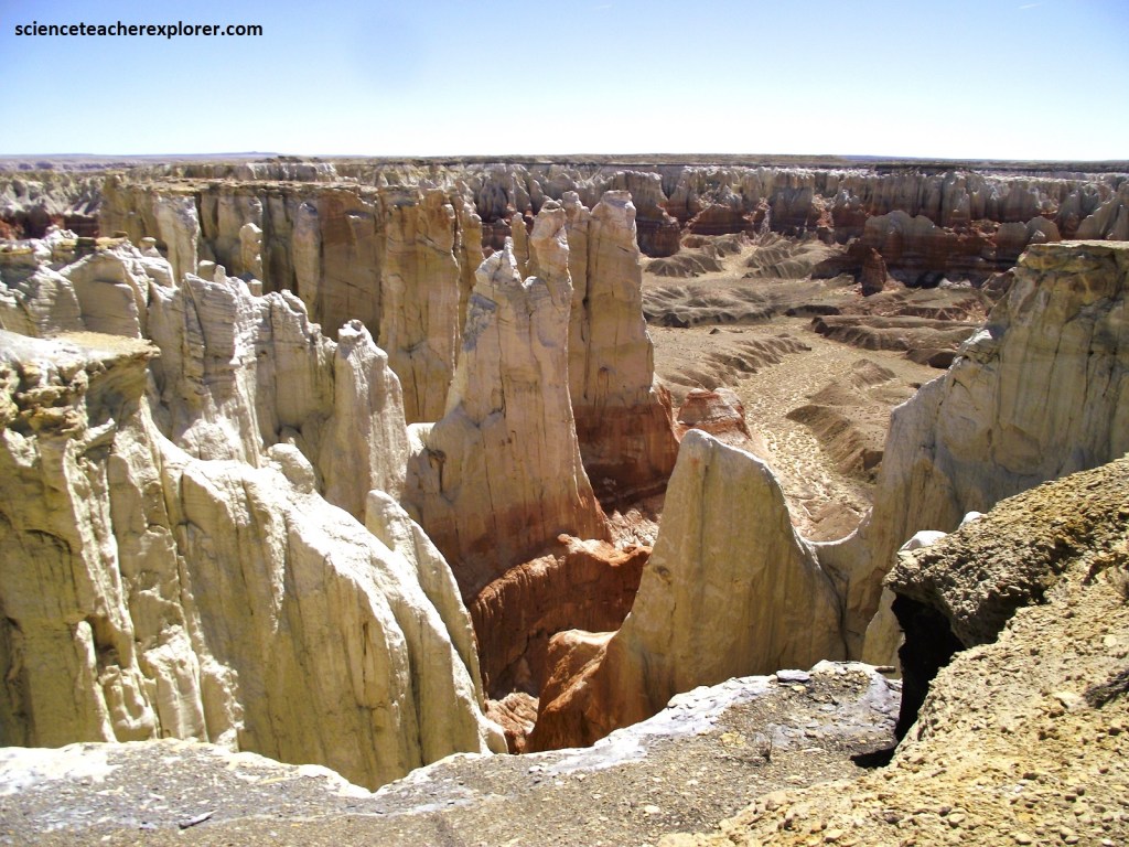
Pictured above, for a complete change of scene, I paused at Coal Canyon, which I reached by a short side trip. The access road exited at a windmill, (there were no signs) and led northward on a dirt road to an overlook. Peering down into the chasm, I could see black layers of coal, (a resource that had been tapped for centuries by native Americans and recently by the Mormons in Tuba City. These thin coal seams were formed more than 100 million years ago along the coast of the advancing Cretaceous seaway. Coal is formed by the accumulation and burial of dead trees and plants in swampy areas. After burial, the deposits of organic carbon are converted into coal by compaction and pressure over time. This is a very poor, low-grade coal and was only mined for short periods of time, though still visible is the terrace cut into the rim of the canyon to dig out the coal.
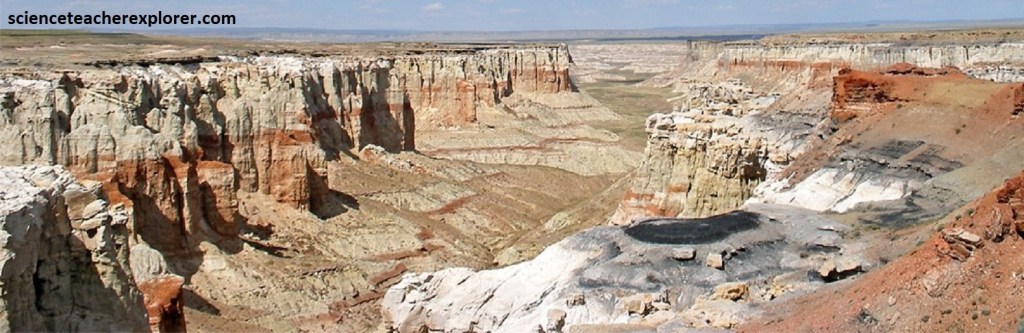
Pictured above, Coal Mine Canyon turns into Blue Canyon along the Moenkopi Wash heading east toward Red Lake on US 160. It’s known to the Navajo a “haahonooji”, meaning jagged, which describes the erosion patterns in the canyon. Its top layer is Dakota Sandstone overlying Cowsprings Sandstone. This gray sandstone deposited in streams that cut channels into the underlying Jurassic sandstone, draining into the coal swamps near the coast. A close look at this sandstone reveals that it is chock-full of black carbonized fragments of wood and plant material. The base of this layer represents the Jurassic-Cretaceous boundary and is an unconformity, because beneath this ledge there is a gap in the geologic record where older rocks were removed by erosion before the sandstone was deposited on top.
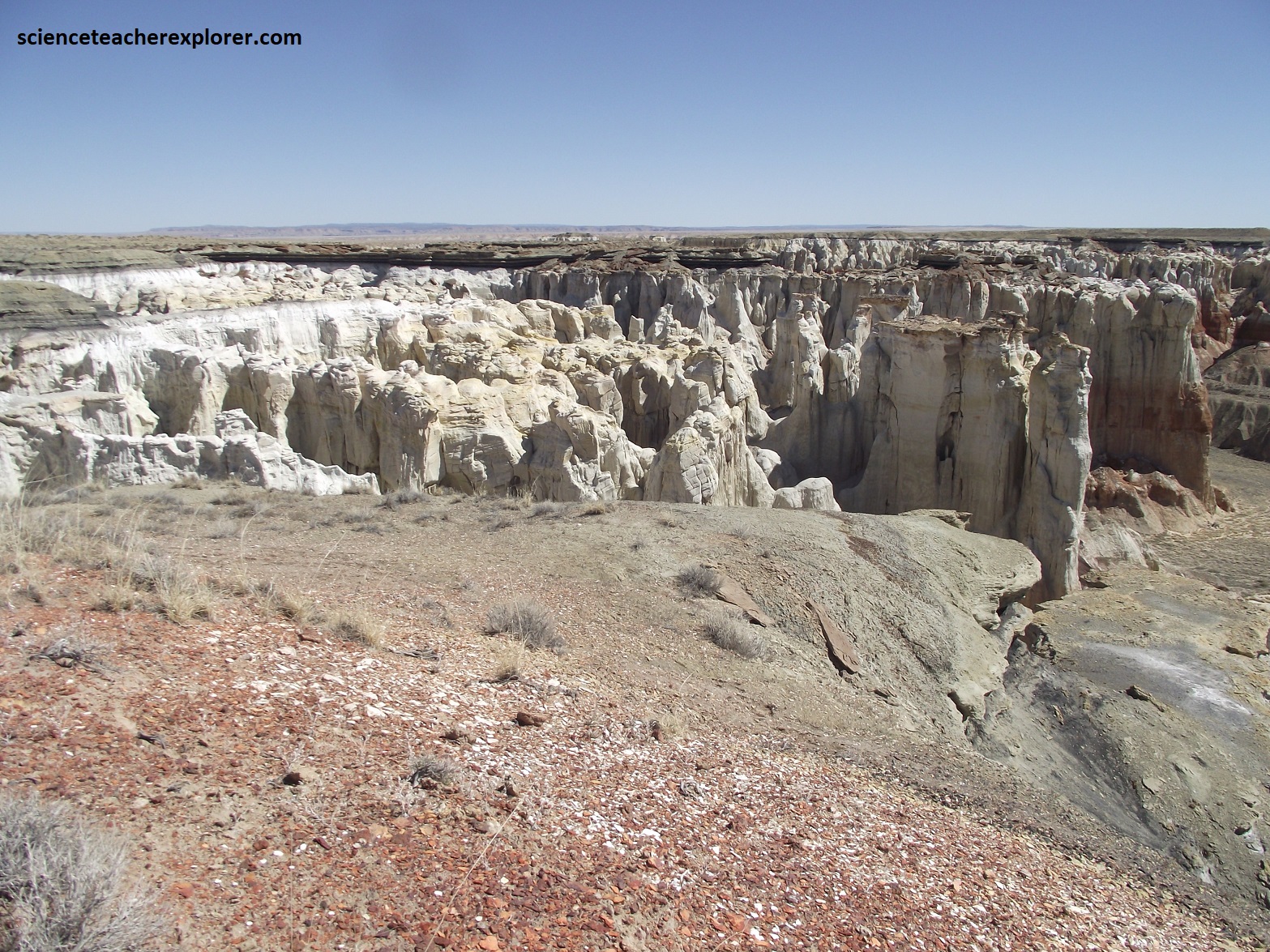
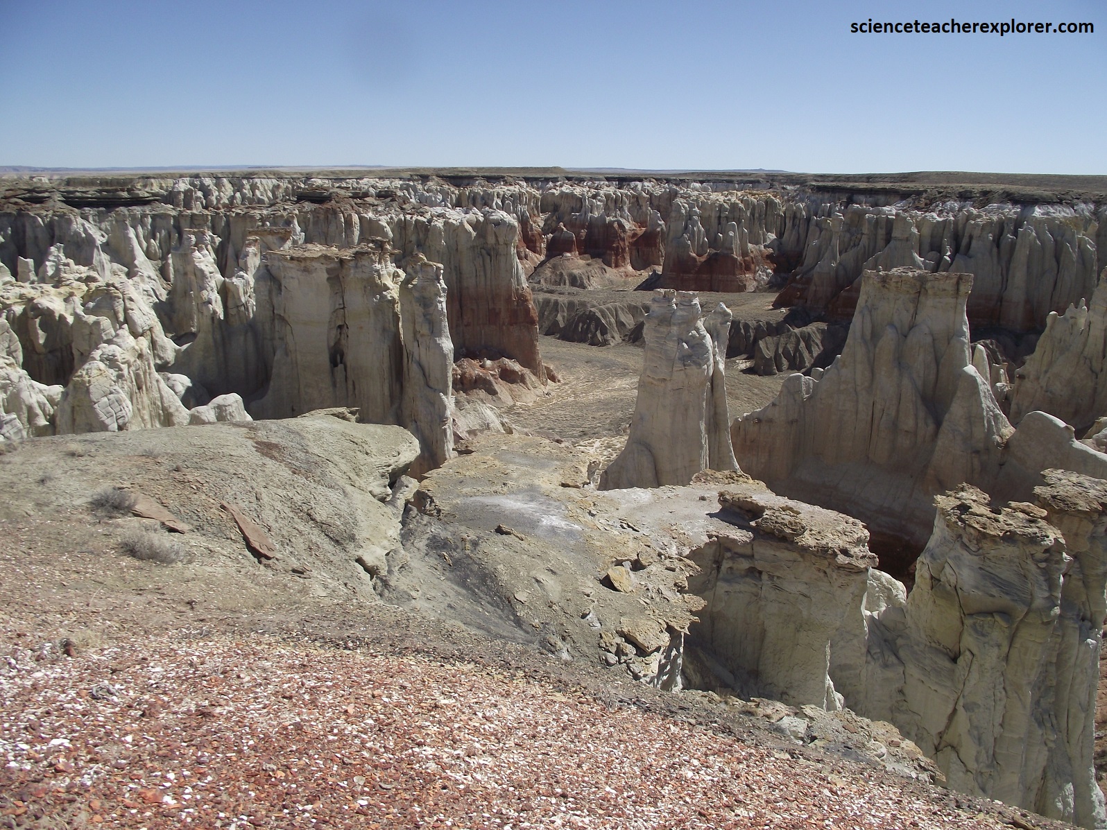
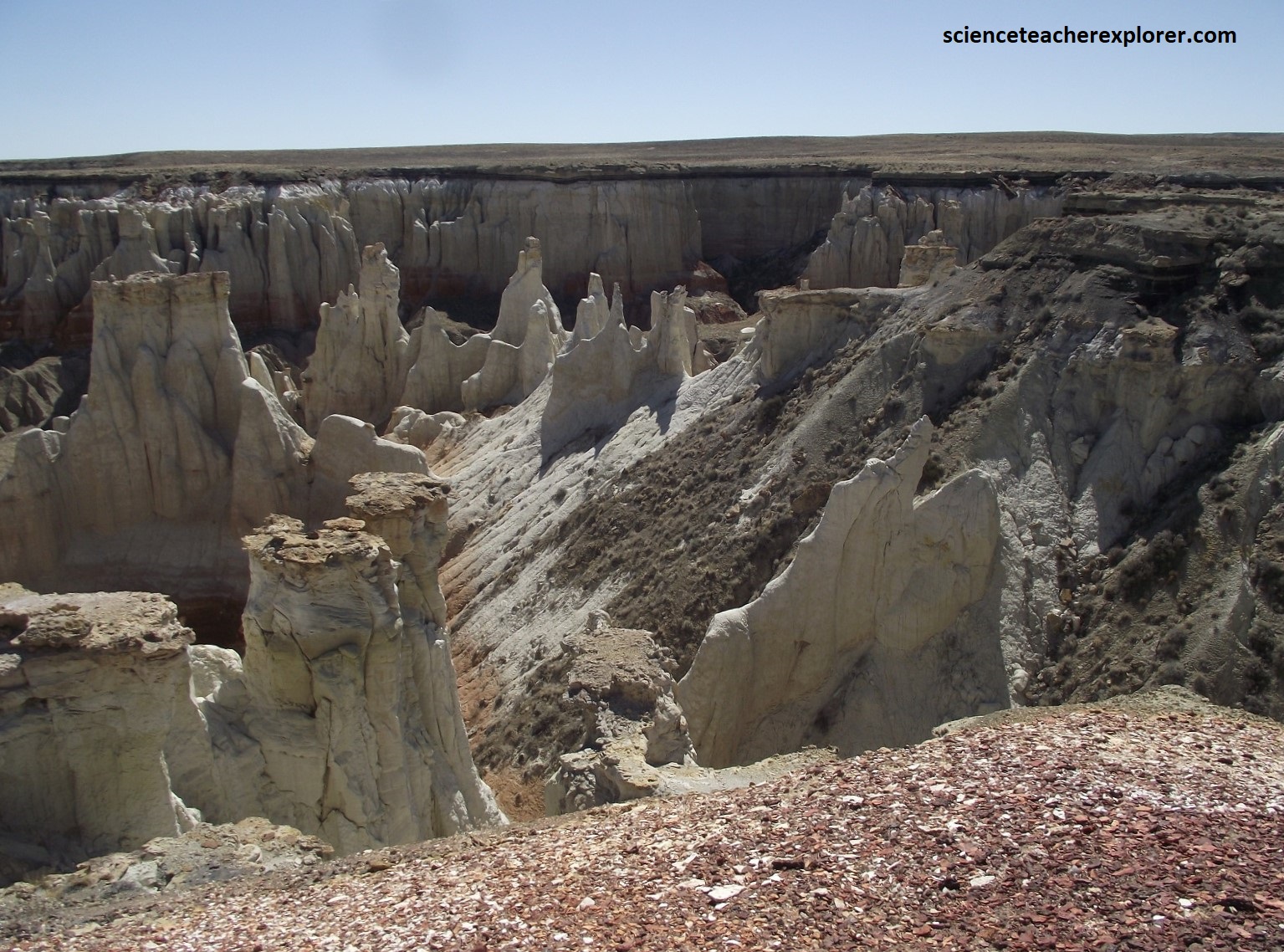
This area is geologically interesting not only for the interesting coal deposits, but also for the vast amount of fossils that can be found around the upper areas of the canyons. Also, three geologic formations, Dakota Sandstone, Cow Springs Sandstone and the Carmel Formation, are exhibited throughout the canyon making it a prime hangout geologists and paleontologists. For those not interested in the physical aspects of the rocks, the canyon provides an amazing example of beautiful array of color typical to rocks of the Colorado Plateau. People say that “For the lucky few, one can go to the edge of the canyon on a summer night, with a full moon and see a shimmering image of what we called ‘The Ghost’ or ‘Quayowuuti’ or Eagle Woman.” [She allegedly became mentally ill and wandered away from the Oraibi village on the path to Moenkopi. Along the way, she stopped to rest on the rim of the canyon and decided to end it all. Ever since, when the conditions are just right, her spirit will appear during the full moon.
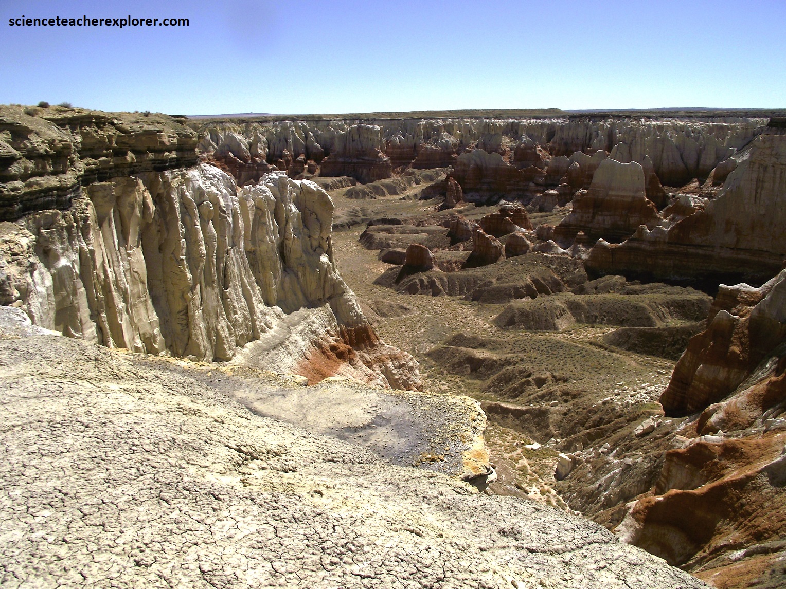
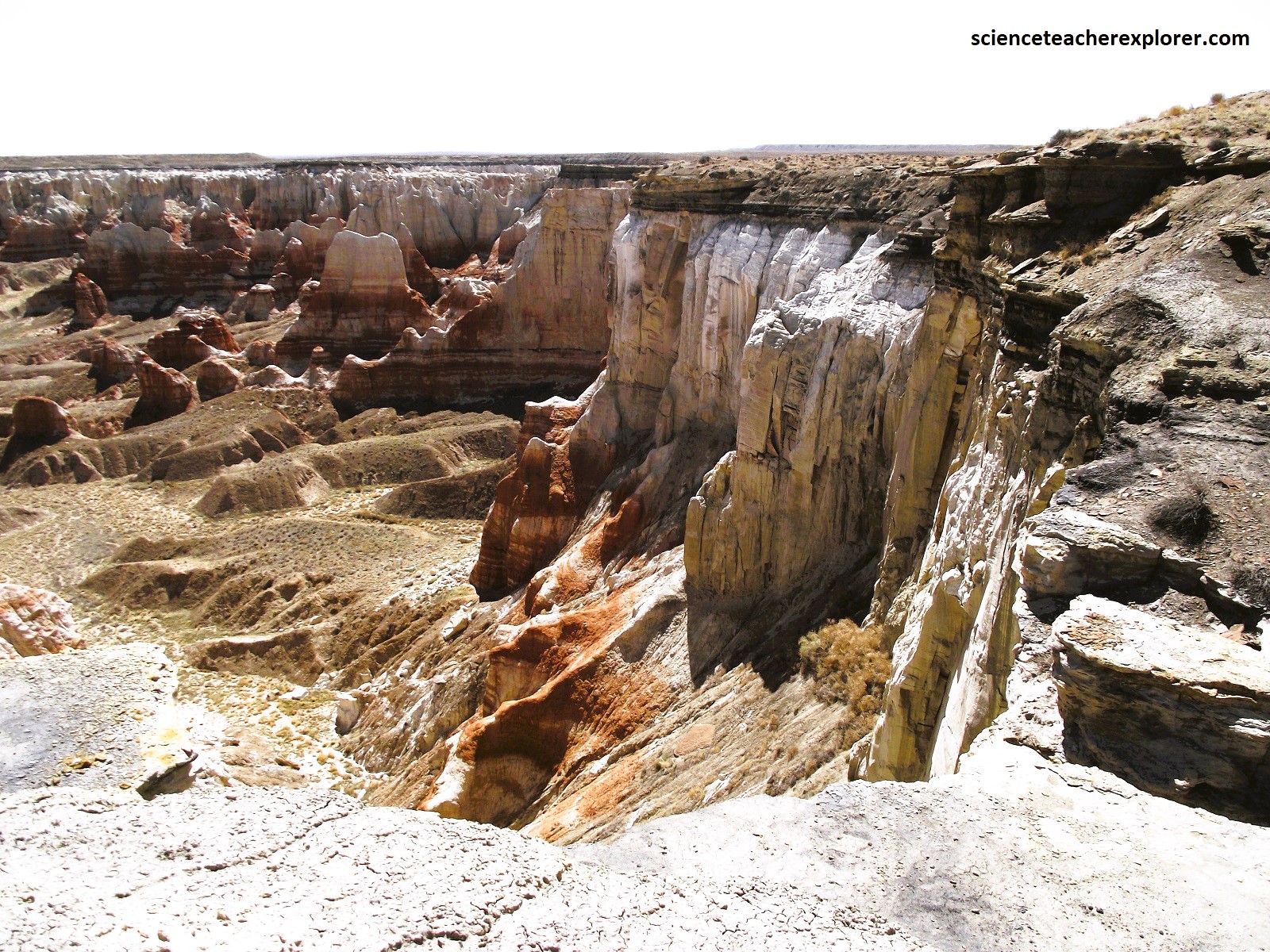
Pictured above, the Dakota Sandstone and Cow Springs Sandstone units are part of the larger San Rafael Group, which is spread all across Utah, Arizona, Colorado, New Mexico and Wyoming. Although it covers vast distances, it is found in greatest quantities in the Four Corners Area of the Colorado Plateau. As mentioned, in Coal Mine Canyon, the Cow Springs Sandstone is topped by the Dakota Sandstone, but as you head north across the border into Utah, the Cow Springs Sandstone begins to fade out. The Carmel Formation lays underneath the Cow Springs Sandstone. It is composed mainly of siltstone and mudstones that are gypsum rich that were also deposited in the Middle Jurassic. Fossils are prevalent throughout the formation. Its rock units are believed to been from a low energy depositional environment that is consistent a coastal environment. The red color of the rock is caused by minute amounts of iron which coated the sand grains as groundwater percolated through the rock while it was deep underground. The prominent color horizons may represent variations in ancient water tables. Laterally, when the Cow Springs Sandstone begins to disappear in the north, the Carmel Formation is then topped by the Dakota Sandstone.
After my side trip into Coal Mine Canyon, I continued driving southeast on highway AZ-264, where it met the southern fringes of Black Mesa, (an enormous tableland that spreads across northeastern Arizona). Along it’s southern edge this giant formation, composed mostly of Late Cretaceous sandstone, tapers into three fingerlike extensions: First, Second, and Third Mesas. These mesas form dramatic terraced pinnacles that peaks at more than 2,337m above sea level and rises more than 200m above the surrounding landscape. These lofty, flat-topped areas have long been inhabitated by the Hopis, who survive by irrigating the land below, planning fields of corn, beans, and squash.
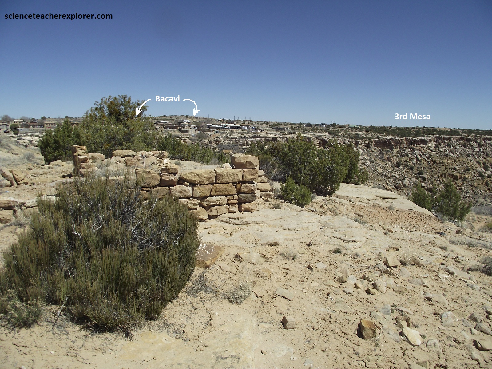
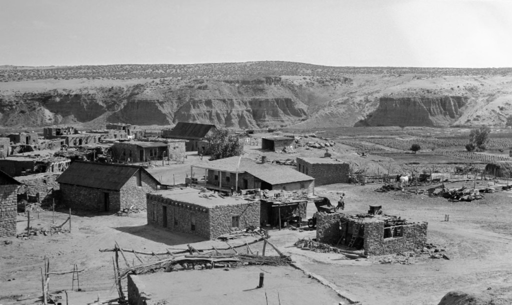
Because early explorers entered the Hopi villages from the east, the mesa siting on the southernmost tip of Black Mesa become First Mesa, with Second Mesa and Third Mesa following. Passing through a steep, narrow canyon on Rte. 264, I climbed from the desert of the west to the Third Mesa. I passed two small villages there, Hotevilla (south) and Bacavi (north). Founded in 1906, Hotevilla became the refuge of Yukioma and his followers after his defeat in a pushing match at Old Oraibi with “friendlies”. This was the name given to Hopis who accepted an worked with the Indian Service. Yukioma was the leader of a faction known as “hostiles” who wanted no services provided by the U.S. and resisted all intervention from the Indian Service and missionaries into the Hopi way of life. After the scuffle Yukioma was arrested by the military and imprisoned at Fort Wingate. This led to a great deal of hardship for his people in their new home. The first winter was particularly difficult. Hoping for reconciliation, a small group returned to Oraibi but were no longer welcome. In 1907, this displaced group started the community of Bacavi, (meaning ‘Place of the Jointed Reed’ in Hopi). Pictured above, I’m standing in the ruins of Old Oraibi, looking towards Bacavi on the Third Mesa.
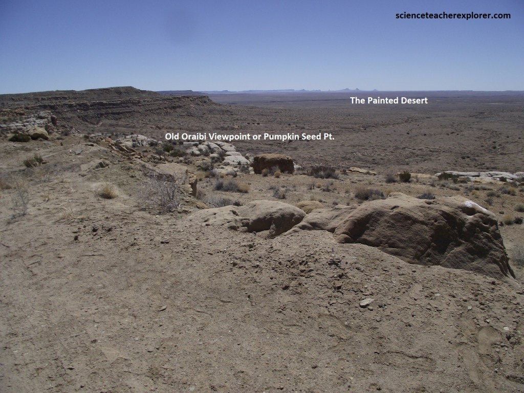
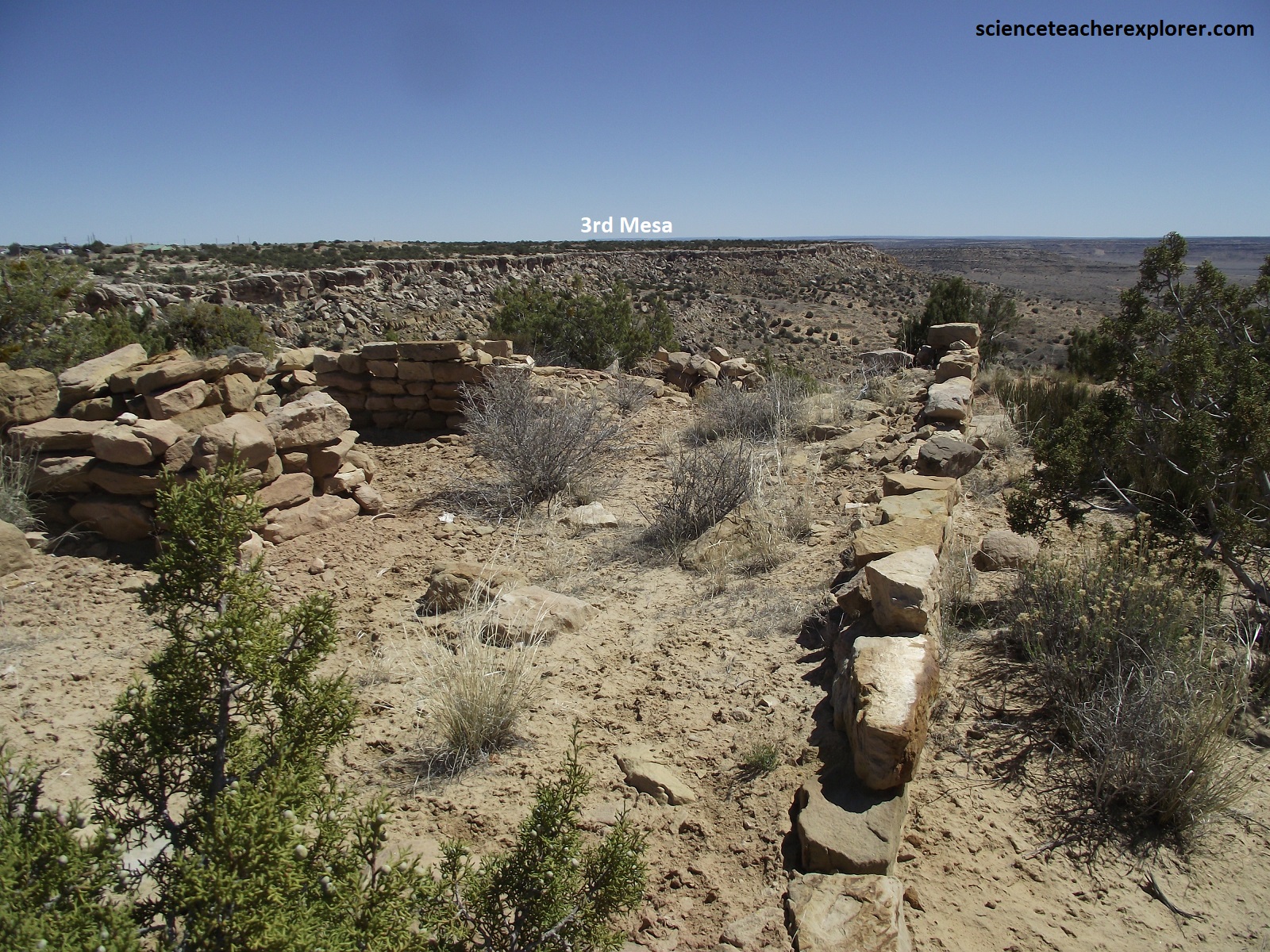
Pictured above, Old Oraibi at the top of the Third Mesa dates all the way back to 1150A.D.. It is said to be America’s oldest continuously inhabited village. This patchwork of stone dwellings, sits 217m above the desert floor. “Orayvi” means place of the Oray Rock, and to the people of Third Mesa, this is ‘Tuwanasavi’, or “earth’s center”. From the Hopi’s Third Mesa, we look west and see the Grand Canyon on the horizon, (at least, on a clear day). South of Third Mesa, we can see the canyon of the Little Colorad River making its way northwest toward the Grand Canyon. A few miles befor the confluence of the Little Colorado with the Colorado River, is a hot springs dome to which the Hopi trace their origins, (mentioned above). In Hopi cosmology, people emerged from the underworld through that very “sipapu” and the dead return to the under world through it. Shrines are located all along the route from the Hopi villages to the Grand Canyon, where the final shrine is located in some small alcoves on the banks of the Little Colorado River. Undertaking a journey to visit these places can be part of growing up Hopi.
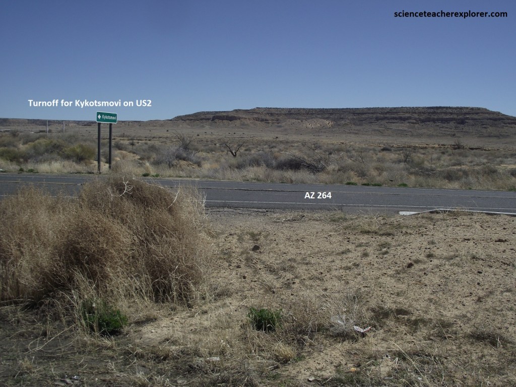
Pictured above, halfway between the Third and Second Mesa is the junction of US-2/AZ-264 and entrance to Kykotsmovi. This is the location of the modern Hopi government. The modern-day politics and bureaucracy that the Bureau of Indian Affairs brought to the “People of Peace” has been a constant source of irritation between villages and clans. Hopis do not differentiate between life and religion. Their sole purpose, and the source of their strength, is found in the adherence to centuries-old teachings and a plan for life. To this end, each village traditionally has a “kikmongwi”, (father of the people), who makes decisions for his village based on prayer and meditation. However, the Mennonite Church has had a strong presence in this community since Heinrich R. Voth built a chapel sometime around 1901 on a path to the “Kachina Resting Place Point”, (Interestingly, it was twice struck by lightning and rebuilt).
Proceeding on Rte. AZ-264, the drive crosses cottonwood-lined Oraibi Wash (a dry streambed) and small plots of Hopi farmland, then ascends to the top of Second Mesa. I stopped at the Hopi Cultural Center, located at the eastern edge of the promontory. It had a restaurant that served traditional Hopi fare & a couple of shops that displayed tribal artifacts. At the restaurant, I tried to blue corn pancakes and noqkwivi, (traditional Hopi ste with lamb and corn). To Hopis, no food is as important as corn, or Qaa’o. Not only is it a dietary staple, its role in Hopi spiritual life is incalculable. To the Hopis, corn is life. Every special event has corn assiciated with it. A perfect ear of white corn represents the spiritual mother of a newborn. At death, a cornmeal path leads the spirit of the decease to its new home.
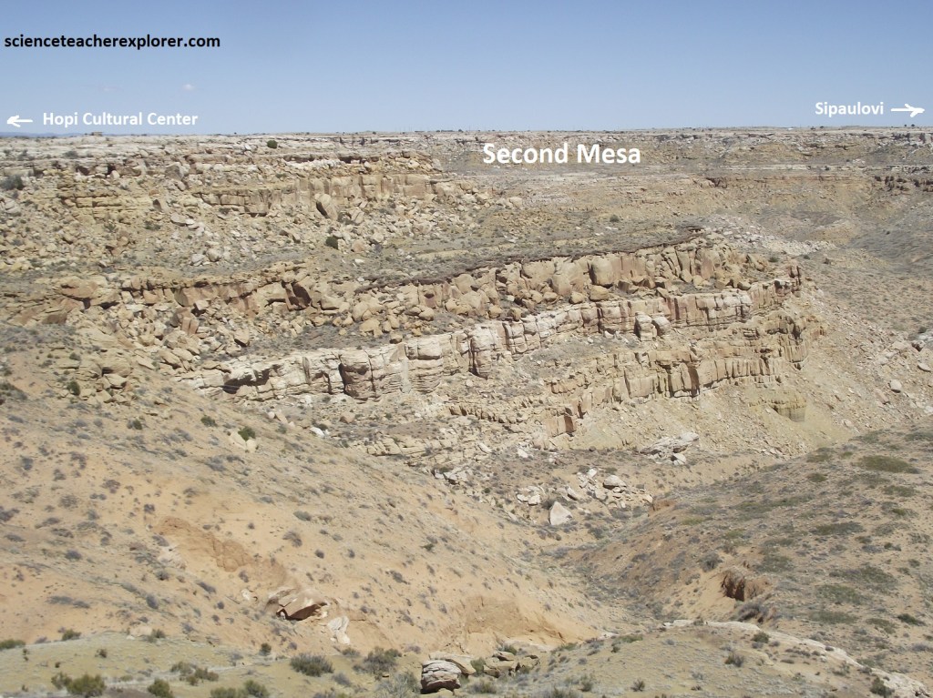
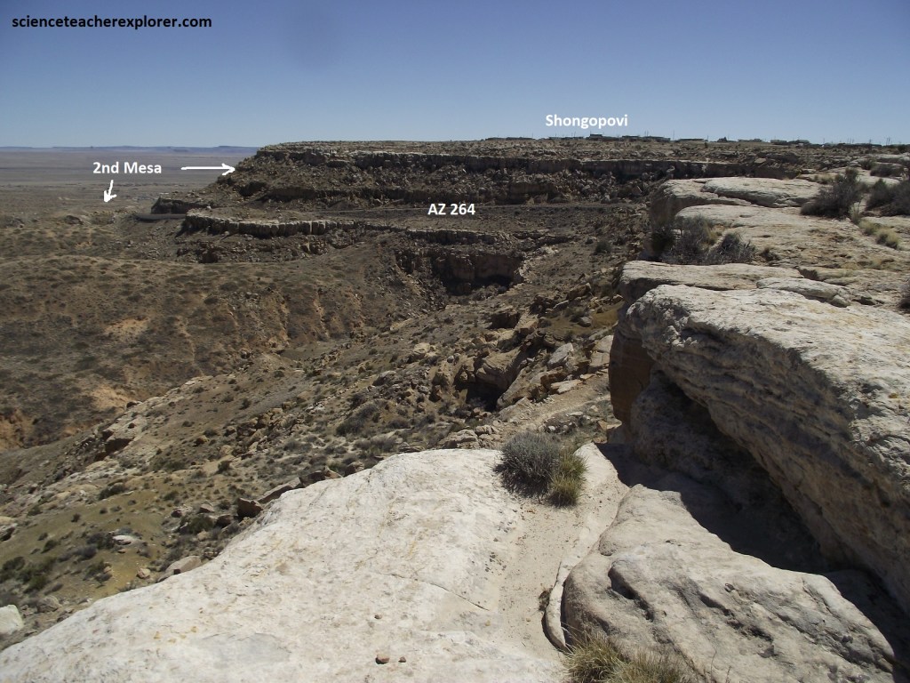
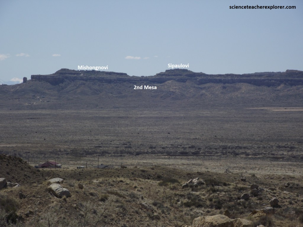
At an elevation of 1,829m, this mesa had two distinct sections. To the east are the villages of Shipaulovi and Mishongnovi, (pictured below). To the west is the village of Shungopavi, (pictured above). In Hopi, “songoopavi” means sand-grass spring-place. It was named for a nearby spring. By tradition, “Old Shungopavi” is the oldest village, established by the Bear Clan, the first clan to arrive on the Hopi mesa after the people’s migrations. The older village is at the base of the mesa, (called 2nd Mesa on the map), where more than 2,000 people lived until fear of retribution of the Spaniards, from the Pueblo Revolt of 1680 caused them to move the village to the mesa top.
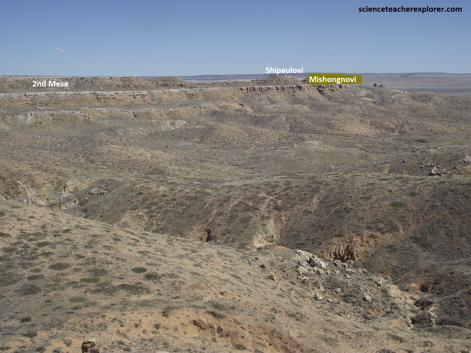
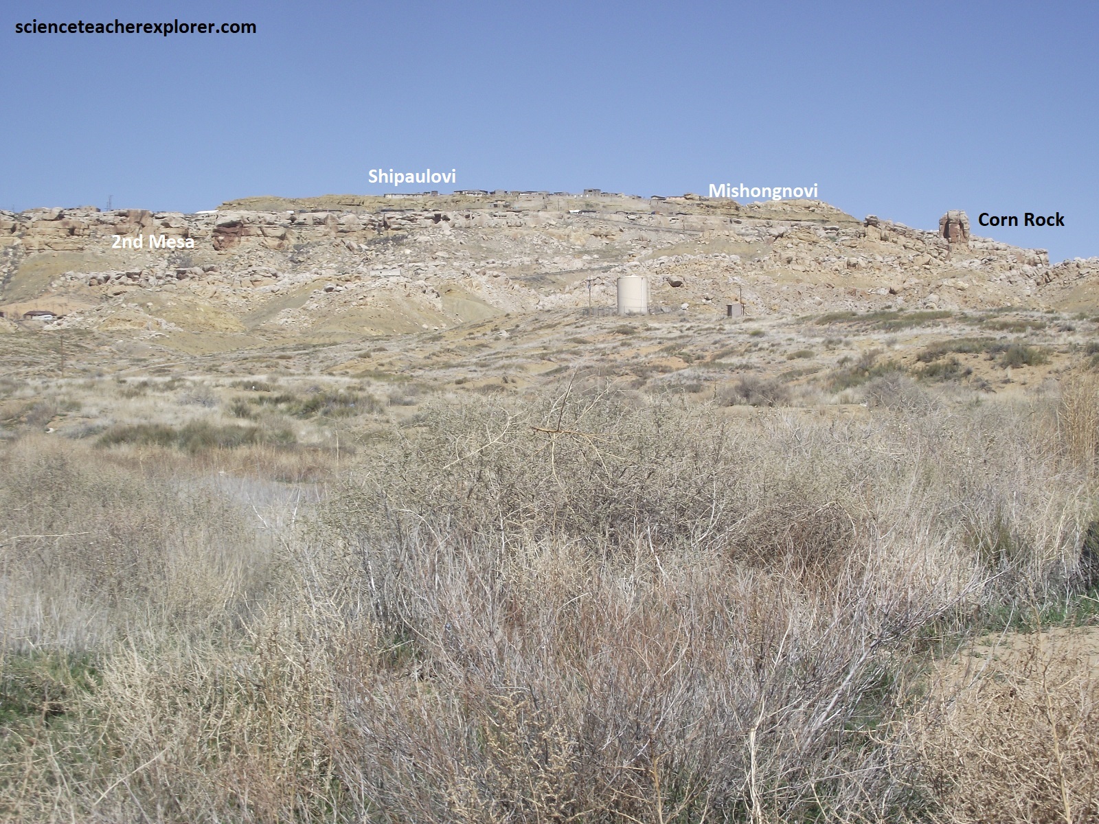
The Crow Clan came to the Hopi mesas looking for refuge. They live in Mishongnovi, (pictured above). Their contribution was to be guardian of the sacred Corn Rock for the people of Shungopavi, (pictured above). {Mishongnovi is the home village of Tony Hellerman’s fictitious character Officer Cowboy Dashee of the Hopi Tribal Police. He is a character in “Sacred Clowns”, “Dark Wind”, and “Talking God”.}
Pictured above, “Supawlavi” means place of the mosquitoes. Tis name stuck when villagers fled “Homol’ovi” to escape the mosquitoes. Homol’ovi refers to the area around Winslow on the Little Colorado River. This lonely place between the Second Mesa Villages, according to Hopi legend, is the Sacred Circle, (the center of the universe).
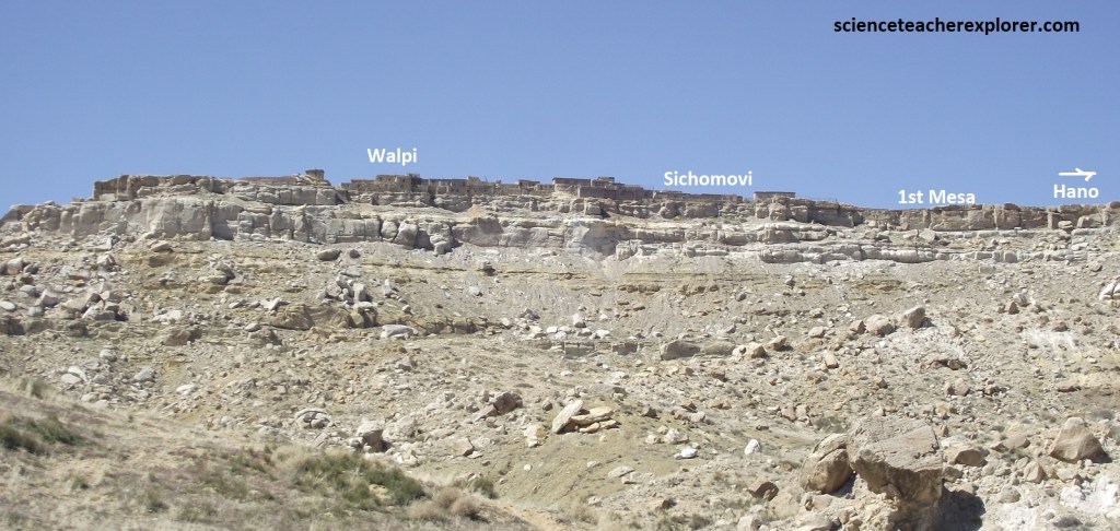
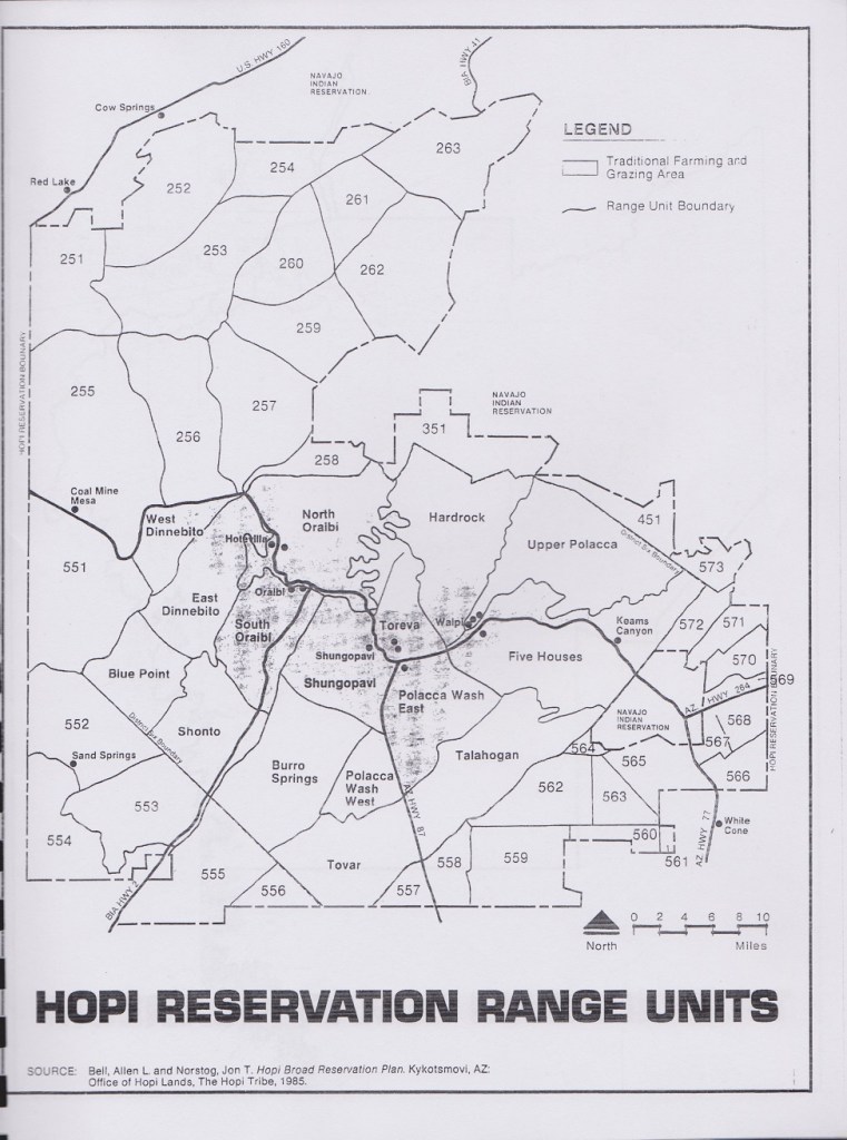
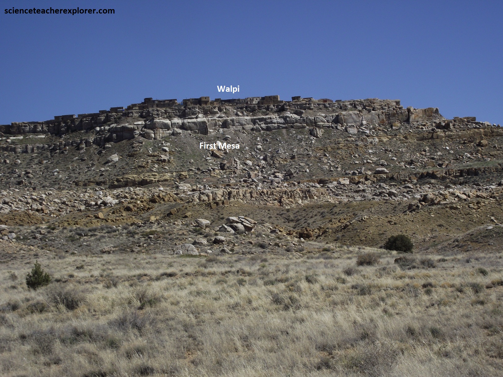
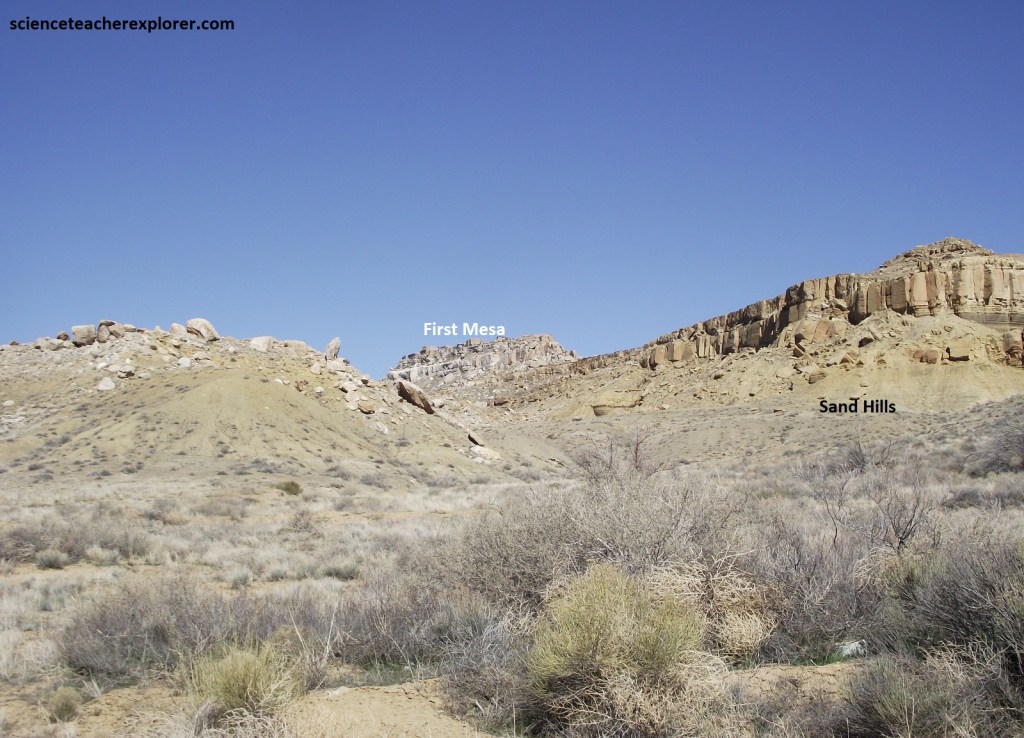
First Mesa, which has the steepest sides and is the narrowest of the three, rises to a height of 200m. It is the easternmost populated mesa jutting out from the Black Mesa core in the Hopi Nation. It contains three villages, Hano, Schomovi, & Walpi. Antelope Mesa is part of the Black Mesa further to the east, but is not occupied. The Wepo and Polacca washes, which traditionally supplied water used in Hopi agriculture, borders either side of the First Mesa.
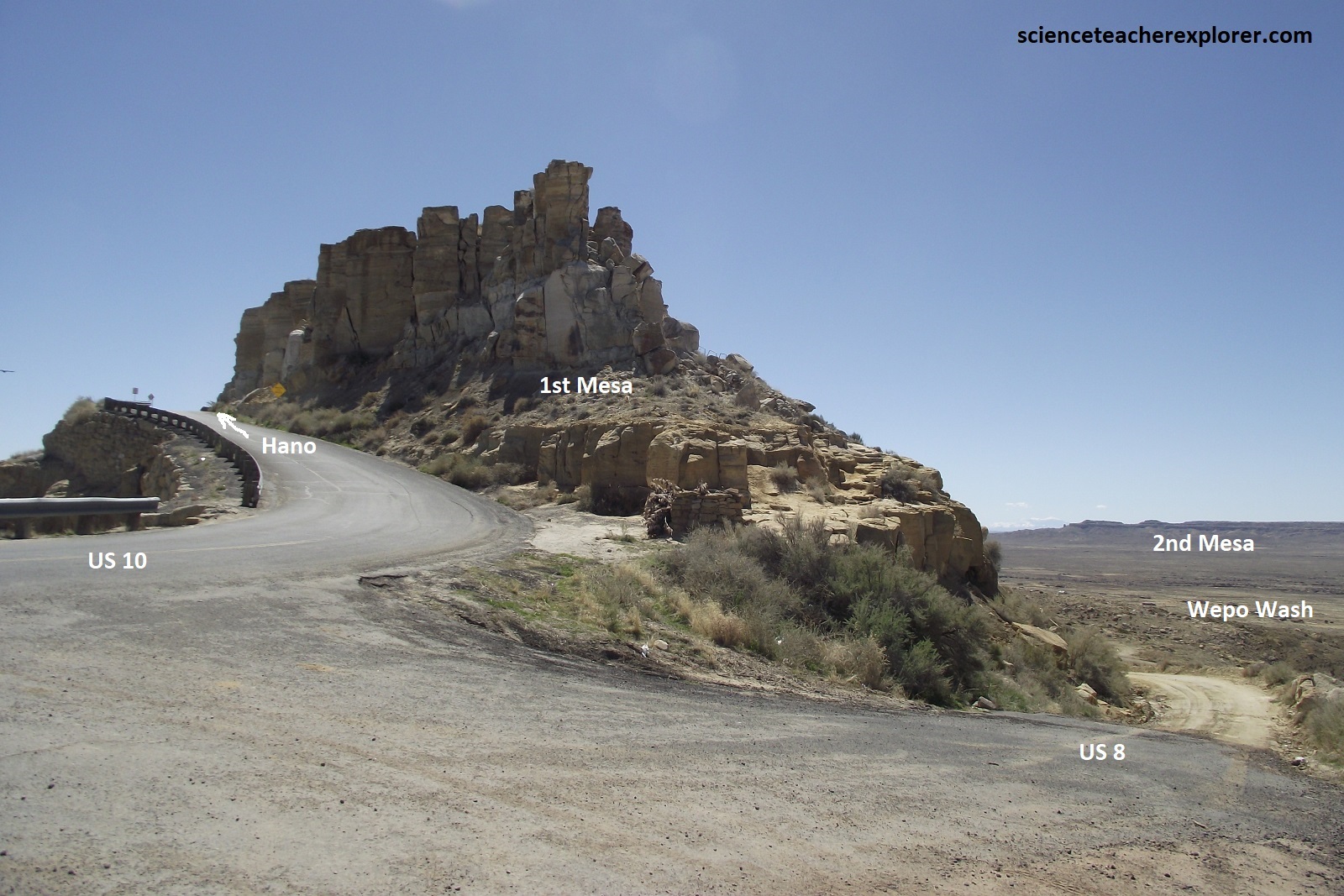
The route up First Mesa makes no attempt to scale its boulder-stewn west wall, but skirts the rocky rubble at the base to the town of Polacca, where a pave side road, (US-10), hugs the eastern cliff as it makes a daring ascent.
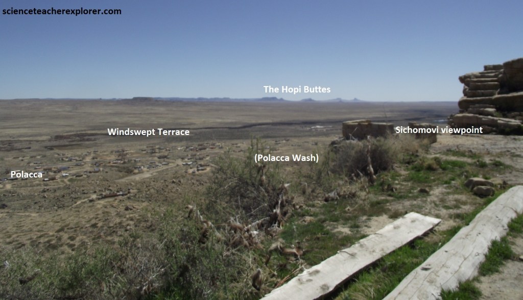
Tom Polacca, a Tewa and former resident of Hano, started this village in 1890. Encouraged by Polacca’s move and looking for ways to disrupt the Hopis’ ceremonial life, the Indian Service tried to lure people down off the mesa by building individual houses by the day school. They were completed in 1900, but no one wanted to move into the homes. By 1935, only 7% of the residents of First Mesa lived in Polacca. Today, the residents of Polacca have maintained their affiliation to political and ceremonial activities on First Mesa. Pictured above, the Hopi Buttes far off to the south are located 64 km away near Dilkon on the Navajo Reservation. In the 1900s, these buttes were known as the Moqui Buttes. The Hopis were force to suffer with the name “moqui”, given to them by the Spanish and carried on by the Indian Service as their official tribal name. To the Hopi, it was an insult to be called moqui, meaning “dead” in their language. The name stuck until the tribe officially petitioned the government to change their name back to Hopi, meaning “peaceful people” or “people who live in the proper way”.
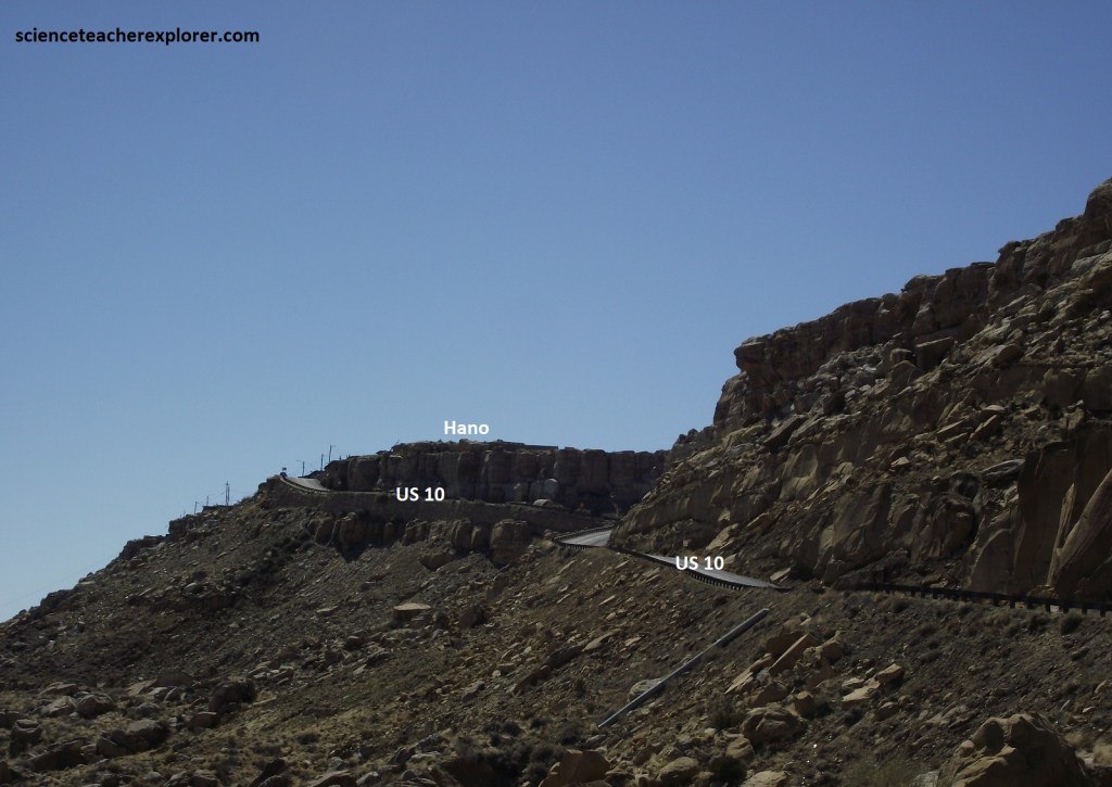
Pictured above, Hano is the first village I drove through when climbing up the steep road to Walpi. Hano is a Tewa village, established by people who come from the Rio Grande area near Albuquerque after the Puebl0 Revolt against the Spanish of 1680. As was customary, each arriving clan was asked by the Bear Clan what they could contribute to the good of the people. The Tewas of Hano contributed their ability to be guardians of First Mesa.
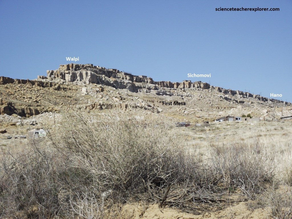
Once on top, the US-10 winds through two villages, Hano & Sichomovi, then suddenly ends. The Hopi name “Sitsomovi” means place of the mounds where wild currants grow. Between Walpi and Hano, members of Walpi founded Shichomovi in 1750. The village has running water, electricity, and garbage pickup. At the end of the road, at a place called Ponsi Hall, I made arrangements for a walking tour of Walpi, (photos of the villages and ceremony were not allowed and I respected that and will not be included here).
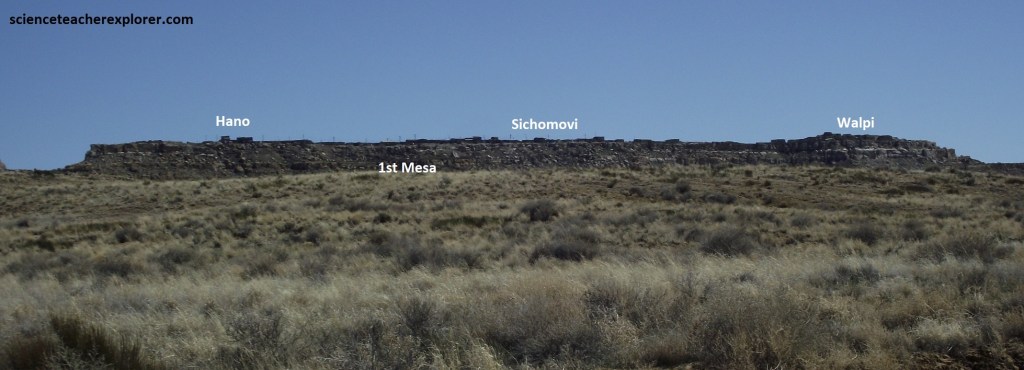
Pictured above, near the tip is Walpi perhaps the most dramatic of all Hopi Villages. “Walpi” means the gap, referring to the opening in the mesa just below Hano, (pictured above on the left side of the photo). The village sits on the narrowest part of the mesa and is only 46m across at its widest point. Just below this village on the northwest side of the mesa is the original village of Old Walpi, where the Hopis’ lived until they moved their village to the top of the mesa. They did this because they feared Spanish retribution after the 1680 Pueblo uprising against the Spanish & Jesuit Rule in 1680.
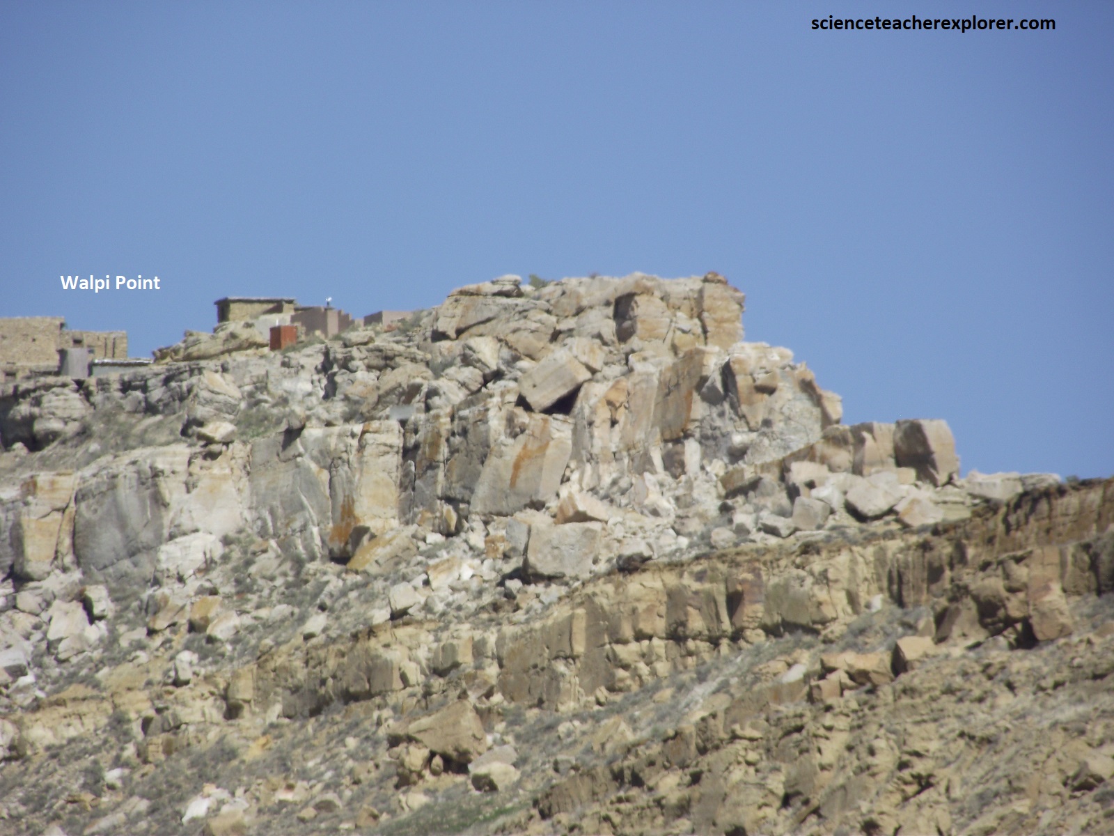
Pictured above, fashioned from the pale Cretaceous sandstone of the mesa, the 300-year-old dwellings look so at one with their surroundings that they seem to have sprouted from the earth itself.
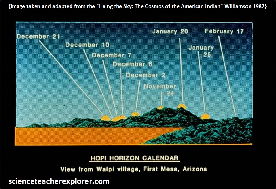
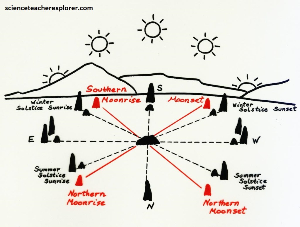
Imaged above, horizon calendars such as this one at the Hopi village of Walpi, allows the Hopi Nation determining the appropriate times for ceremony and for planting and harvesting. For example, when the sun sets in the place known as Lu-ha-vwu Chochomo, the Hopi know that winter solstice will occur about eleven days later, (note the twelve days of Christmas). Sun watching is a ceremony itself, but it is often done for the sake of ceremony. At Hopi, the major ceremonies Wuwuchim (the beginning of the ceremonial year when the kachinas return), Soyal (the winter solstice ceremony), the Niman (the date when the Kachinas return home) are all set by noting the arrival of the sun at certain horizon features, just as the planting and harvest dates are set. Each of these ceremonies celebrates the Hopi connection with the natural world of sunlight, rain, and the cycle of the crops. In addition to the sun shrines that exist near the pueblos, it is customary to erect shrines at the spot on the horizon at which the sun seems to rise or set at specific times, (sometimes many kilometers away and tended by human runners).
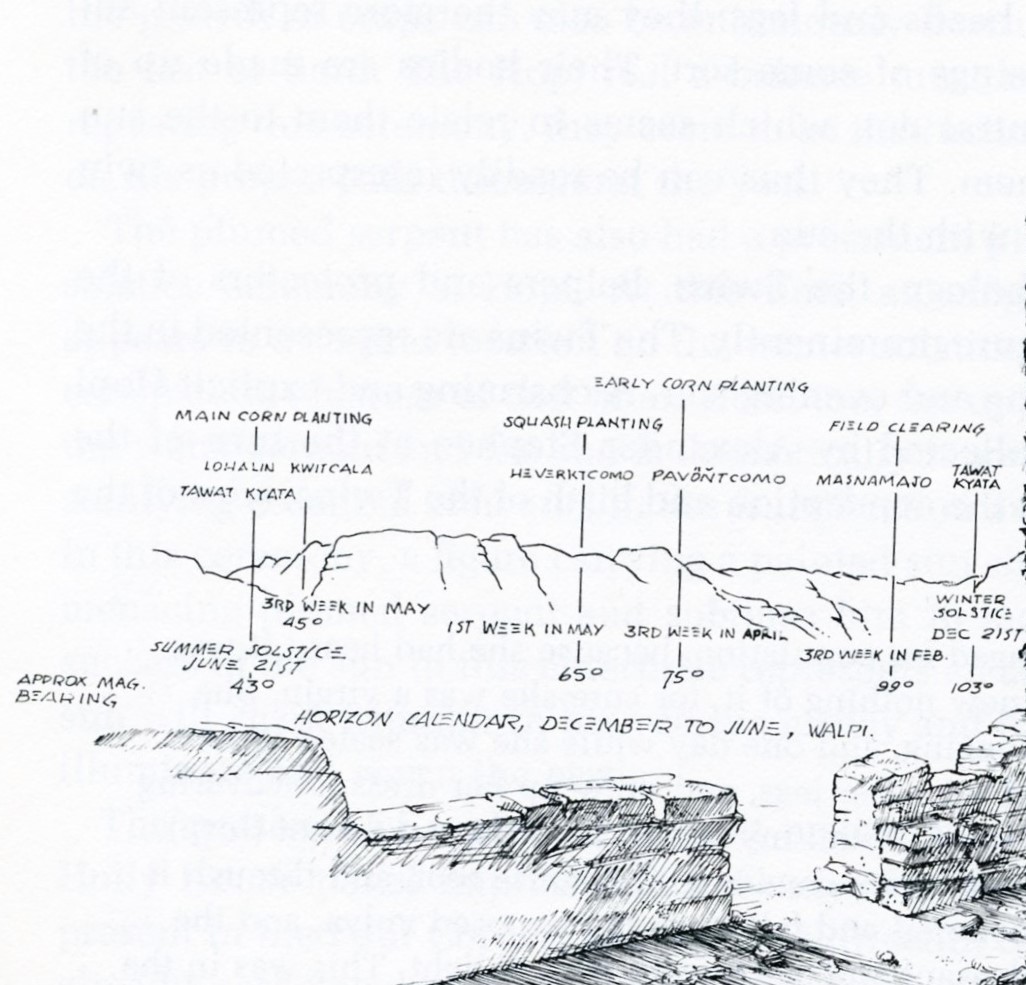
When the sun reaches the appropriate place along the horizon, the Hopi know it is safe to plant certain crops. By February 20, it would be time to begin preparing the field for planting. A month later, on March 21, at the equinox the sun priest would know that in about twenty days, (April 10th), the first corn planting could be made.
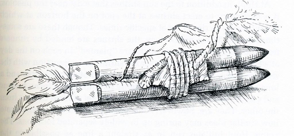
Sun watching, though an intensely practical pursuit, is also deeply religious for the Hopi. Imaged above, the Hopis’ present prayer sticks to the sun as offerings. These prayer sticks were offered at a sun shrine on the summer solstice. Sun watching is a ceremony itself, but it is often done for the sake of ceremony. At Hopi, the major ceremonies Wuwuchim (the beginning of ceremonial year when the kachinas return), Soyal (the winter solstice ceremony), and Niman (the date when the kachinas return home at the Little Colorado River Hopi-Sipapu) are all set by noting the arrival of the sun at certain horizon features, just as the planting and harvest dates are set. At Hopi, in addition to the sun shrines that exist near the pueblos, it is customary to erect shrines at the spot on the horizon at which the sun seems to rise or set at specific times.
Visible at intervals along the way on AZ-264, dry creek beds are about the only breaks in the sameness of the desert until the drive reaches the town of Kearns Canyon in the east, (named after a former trader and Indian agent, Thomas Kearns). Although it has a center for native crafts, this is a government outpost, not a Hopi village. A short side trip to the northeast led me into the town’s namesake canyon, (pictured below).
Before 1860, Kearns Canyon was known as Peach Orchard Springs. The Hopis call this natural oasis Pongsikya. After the Navajos signed a treaty with the Spanish in 1819, they began to settle in Hopi territory. Prior to this, there had been a long history of conflicts between Hopi farmers and some Navajo clans. Nonetheless, in 1863 when the U.S. decided that the Navajos were causing too much trouble for white settlers and Hopis, they sent in the Army. Col. Kit Carson, with the aid of one hundred Hopis, Utes, and white volunteers from New Mexico, waged a fierce and cruel campaign to force the Navajos to surrender and move from the area.
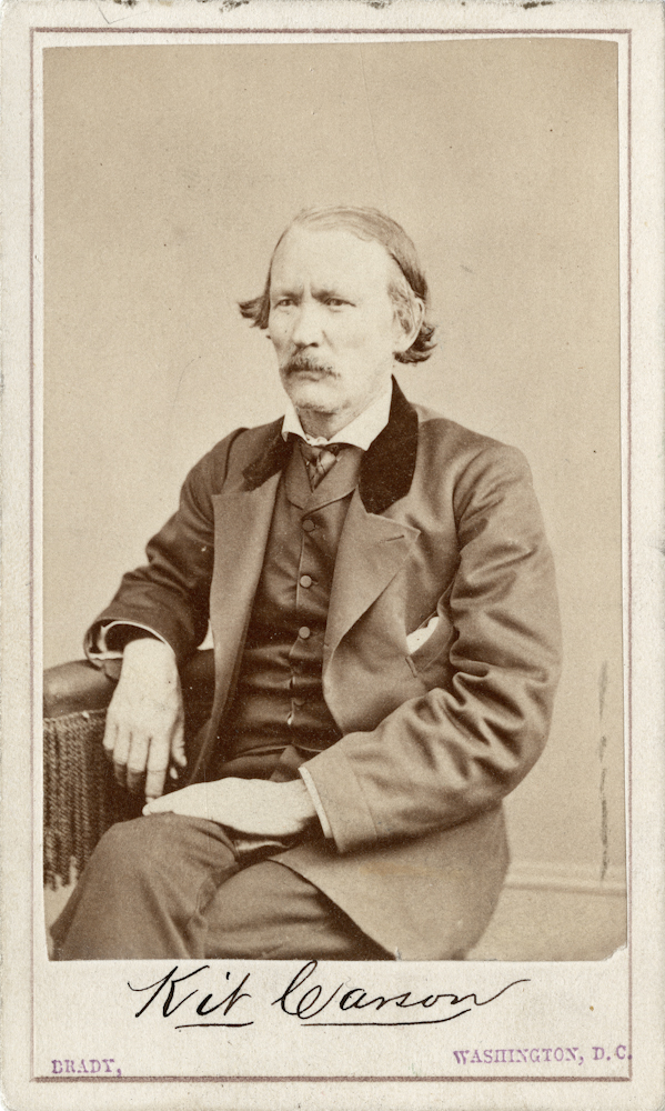
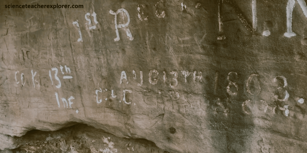
Carson assembled his legion in Peach Orchard Springs. Scored on the canyon wall behind the BIA Agency building is an inscription that reads: “1st Reg’t N.M. Vol’s., Aug 13, 1863, Col. C. Carson, Comm,”; (pictured below). {Note the poor condition of this historical inscription; I expect it too disappear soon}.
After trekking and exploring Kearns Canyon, I made my way down to the Junction of AZ-264/US-8, 13 km away. I turned south on US-8, to explore the Hopi Buttes, towards Holbrook, Arizona. Eventually, US-8 turns into AZ-77.
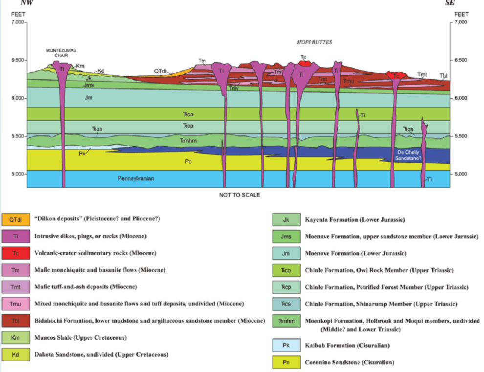
Formed between 8.5-6 million years ago, the Hopi Butte were not typical volcanoes. the eruptions were violent, yet they did not form the usual volcanic cones. The Hopi Buttes formed when rising magma encountered the saturated lakebeds of the Bidahochi Formation, causing water to flash into steam. Steam-driven explosions blew out v-shaped vents, called diatremes, topped by shallow circular craters, called maars. Diatremes is a greek word meaning “object that cuts across”. These v-shaped cavities were drilled out by gas charged magma escaping at a great velocity in explosive eruptions. The gas is water vapor produced when the magma vaporizes groundwater.
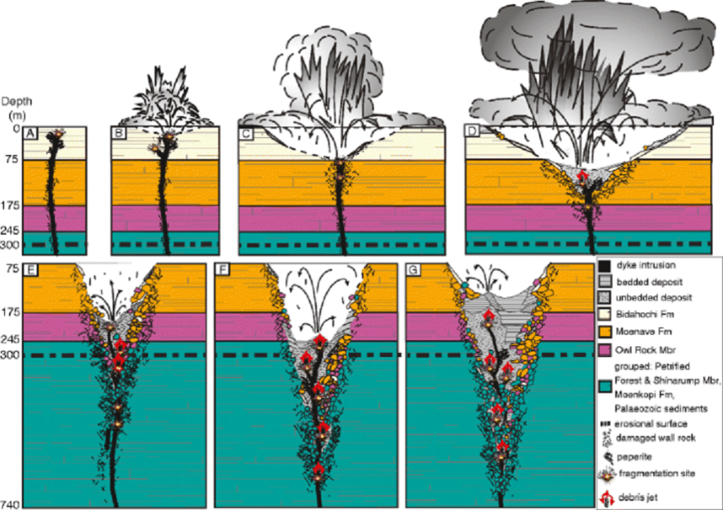
The lava was later buried by younger lakebeds. Later, erosion stripped away many softer deposits, revealing the diatremes as buttes of resistant volcanic rock as much as sever hundred meters high.
Most of the 300 or so Hopi Buttes lie within the Navajo and Hopi reservations. At the Junction of US-6/US-15, I turned left, (northeast) to visit the Red Clay Mesa & Satan Butte areas, (pictured below).
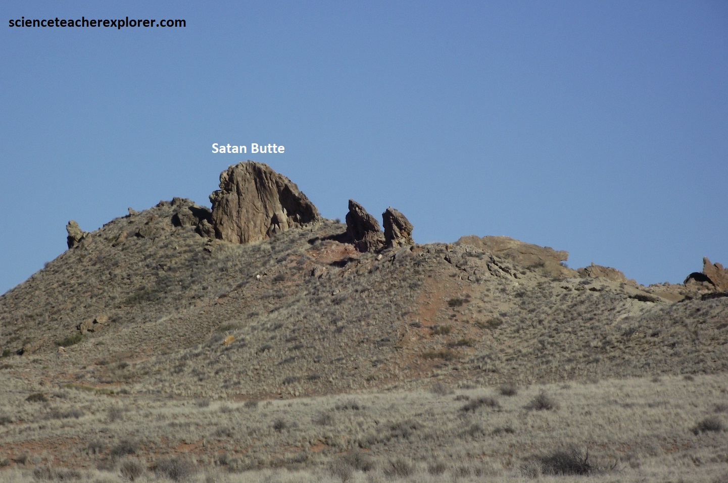

Pictured above, the Morale Claim produced uranium from the sediment deposited within the maar of Red Clay Mesa, and a complete cross-section of a diatreme and maar is visible from the nearby Satan Butte and it’s standing rocks.
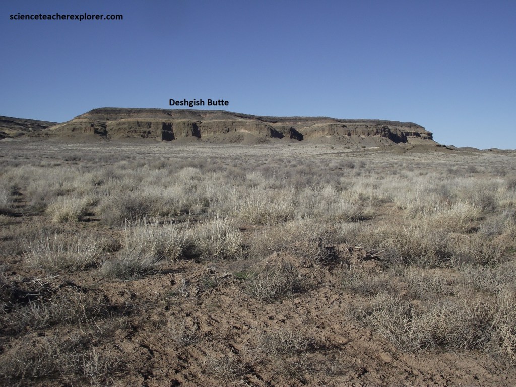
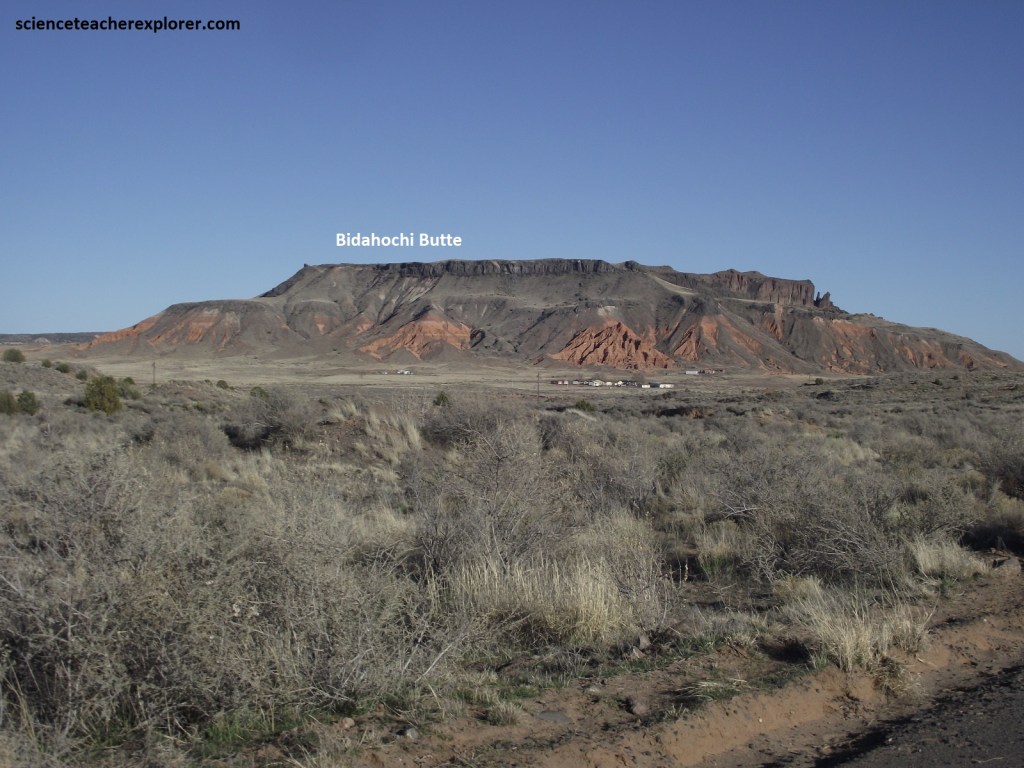
The diatremes were drilled through the reddish siltstone, sandstone, and shale of the Bidahochi Formation, which then covered the area. This unit was deposited either in one large lake or in several shallow and ephemeral ones. Pictured below, on the right-side of Bidahochi Butte, you can see the Bidahochi Formation as reddish outcrops on the flanks of the butte. The lava cap of the butte mark the top of the formation. The Bidahochi Formation is poorly consolidated and prone to sliding, producing the landslide apron that surround it. This is common in most of the surrounding Hopi Buttes. Note that the basalt, (lava), above the formation, together with layers of volcanic tuff within it, bracket the age of the Bidahochi between about 14-7 million years. Erosion since then has lowered the landscape valley weveral hundred meters to it’s present level.
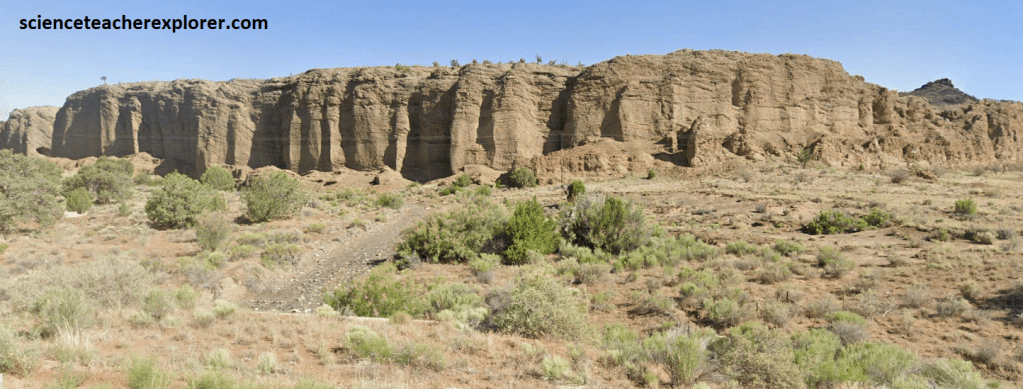
Just south of Bidahochi Butte, I turned right, (west) on US-15 near the Indian Wells Chapter House. In about 6.8 km, the Coliseum Diatreme comes into view on the north side of the road, (pictured below). The stadium-like shape of this deposit is due to two factors: (1) No capping lava flow buried the crater of the diatreme. (2) The Bidahochi Formation, into which the diatreme was drilled, erodes more easily than the tuff and limestone in its interior. Consequently, the rock once forming the outside wall of the diatreme has been eroded away, leaving behind the diatreme’s fill. The walls of the ancient v-shaped vent were just outside the present Coliseum’s wall. The process by which a formerly low area becomes high through differential erosion is called topographical inversion.
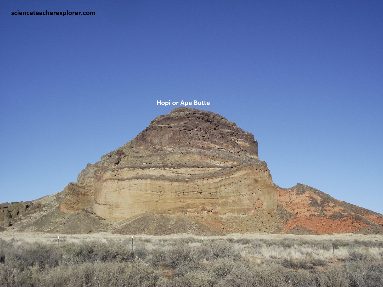
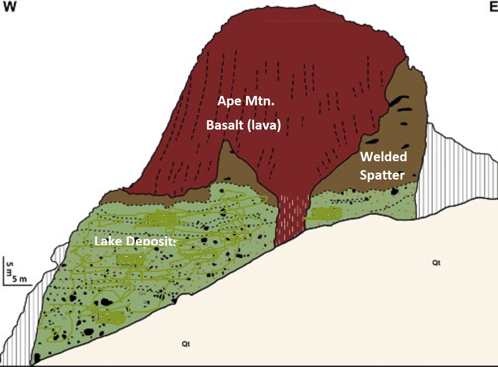
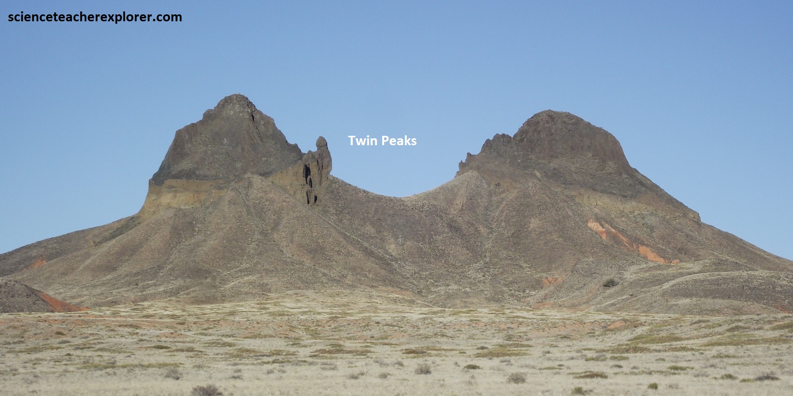
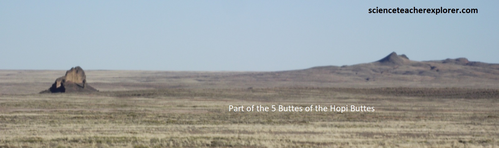
Returning to US-8 and driving south, the highway passes between the diatremes called, Ape Mtn., Twin Peaks and the Five Buttes, (pictured below).
Nowhere in America is the Native American territory so extensive as in north-eastern Arizona, where the Hopi and Navajo Nations comprise some 78,000 square kilometers. Part of the Colorado Plateau, the region, though dry and barren, abounds with a serene, uncrowded beauty. Measure the riches here not in material wealth but in such thins as the vast vistas to be seen from atop tall mesa, and the magical colors that paint the desert sky at sunup and sunset.